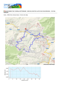
MOUNTAINBIKE-TOUR TOUR VAL GARDENA - VALLUNGA - S. GIACOMO VON MTBSCHOOL - 27,16 KM - RUNDKURS
Italien , 39046 Ortisei, Bolzano-Bozen, Trentino-Alto Adige
Höhendifferenz
554 Meter (Höhe von 1.251 Meter bis 1.805 Meter)
Gesamtanstieg: 860 Meter, Gesamtabstieg: 861 Meter
Beschreibung der Strecke
Von St. Ulrich (1.255 m) geht's auf dem Radweg (Asphalt) nach St. Christina und Wolkenstein (9km), danach leicht bergauf über
eine Panorama Schotterstrasse in das Langental (1805 m/13 km). Nach einer kleinen Pause biken wir zurück Richtung
Wolkenstein und "Plan da Tieja". Anschließend erfolgt ein Aufstieg nach (Plejdinaz 1630 m/22 km) zur St.Jakobs Kirche, einem
der schönsten Aussichtspunkte Grödens mit Blick auf die Langkofelgruppe. Von St. Jakob gelangen wir auf einem Singeltrail in
das Annatal und zurück bis nach St.Ulrich.
Start: 1.255 Meter
Max Höhe: 1.805 Meter - 554 Meter (Höhe von 1.251 Meter bis 1.805 Meter)
Gesamtanstieg 858 Meter
Gesamtabstieg 858 Meter
Streckenlänge: 27 km
Fahrdauer ca. 2:40 Std. - Tourdauer ca. 4:00 Std.
Ausdauer *** Technische Abfahrten ***
Da Ortisei (1.255 m) sulla pista ciclabile asfaltata verso S. Cristina e Selva (9 km), poi leggera salita su una strada sterrata fino in
Vallunga (1805 m / 13 km). Dopo una breve pausa ritorno a Selva, proseguimento verso "Plan da Tieja" e salita (Plejdinaz 1630 m
/ 22 km) per la Chiesa di San Giacomo, dove si può godere di una magnifica vista panoramica sulla Val Gardena e sul Gruppo del
Sassolungo. Da S. Giacomo si prosegue su un single trail verso la Val d'Anna fino a Ortisei.
Partenza: 1.255 m
Altitudine max.: 1.805 m - Dislivello: 554 m
Totale dislivello in salita: 858 m
Totale dislivello in discesa: 858 m
Lunghezza percorso: 27 km
Durata: circa 2:40 ore - Durata dell'intero tour: circa 4 ore
Condizione *** Discese tecniche ***
We depart at Ortisei (1.255 m) on the bike path (asphalt) to S. Cristina and Selva (9km), then slightly uphill on a gravel road to
Vallunga (1805 m/13 km). After a short break we head back to Selva and "Plan da Tieja". Afterwards to Plejdinaz (1630 m/22 km)
and to the church of S. Giacomo, from there through the Val d'anna back to Ortisei.
Departure: 1.255 meters
Max height: 1.805 meters - 554 meters (height from 1.251 meters to 1.805 meters)
Total increase: 858 meters
Total descent: 858 meters
Track length: 27 km
Duration: approx. 2:40 hours - Duration of tour: apporx. 4:00 hours
Endurance *** ** Technical descents *** **
We depart at Ortisei (1.255 m) on the bike path (asphalt) to S. Cristina and Selva (9km), then slightly uphill on a gravel road to
Vallunga (1805 m/13 km). After a short break we head back to Selva and "Plan da Tieja". Afterwards to Plejdinaz (1630 m/22 km)
and to the church of S. Giacomo, from there through the Val d'anna back to Ortisei.
Departure: 1.255 meters
Max height: 1.805 meters - 554 meters (height from 1.251 meters to 1.805 meters)
Total increase: 858 meters
Total descent: 858 meters
Track length: 27 km
Duration: approx. 2:40 hours - Duration of tour: apporx. 4:00 hours
Endurance *** Technical descents ***
Koordinaten des Startpunktes
Koordinaten des Endpunktes
Breitengrad: N 46°34.592' / N 46°34'35.572" / N +46.5765480 Breitengrad: N 46°34.596' / N 46°34'35.771" / N +46.5766033
Längengrad: E 11°40.471' / E 11°40'28.305" / E +11.6745293 Längengrad: E 11°40.482' / E 11°40'28.962" / E +11.6747117
© Copyright 2026 Paperzz