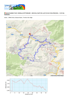
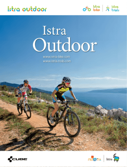
MOUNTAINBIKE-TOUR SELLA RONDA TRACK CLOCKWISE VON MTBSCHOOL - 63,85 KM - EINWEG-STRECKE
Italien , 39048 Selva, Bolzano-Bozen, Trentino-Alto Adige
Höhendifferenz
1.216 Meter (Höhe von 1.252 Meter bis 2.468 Meter)
Gesamtanstieg: 3.617 Meter, Gesamtabstieg: 3.993 Meter
Beschreibung der Strecke
Die Sella Ronda Mountainbike ist eine eindrucksvolle Tagestour mit einmaligen Panorama Aussichten auf die Dolomiten. Mit den
Aufstiegsanlagen gelangen Sie einfach und bequem auf die Dolomitenpässe wie das Grödnerjoch, den Campolongopass, das
Pordoj- und das Sellajoch. Die Tour ist ausschließlich in Begleitung eines erfahrenen, ortskundigen Mountain Bike Guides
befahrbar und kann im oder auch gegen den Uhrzeigersinn bewältigt werden. Gestartet wird in beiden Fällen in St. Ulrich. Auf
der Sellaronda Mountainbike erwarten Sie unter anderem spektakuläre Talabfahrten auf technischen Singletrails.
Tagestour: 8.15 – 17.00 Uhr
Tour im Uhrzeigersinn:
Länge: 65 km, 550 Höhenmeter zu treten (3.980 hm insgesamt)
Ausdauer *** Technische Abfahrten ****
Il Sella Ronda mountain bike è un tour giornaliero intorno al Gruppo del Sella, che offre viste panoramiche mozzafiato sulle
Dolomiti. I passi dolomitici Gardena, Campolongo, Pordoi e Sella sono comodamente e facilmente raggiungibili con gli impianti di
risalita. Il tour è percorribile solo in compagnia di una guida mountain bike esperta e può essere fatto in senso orario o
antiorario, sempre partendo da Ortisei. Durante questo tour in mountain bike Vi aspettano discese tecniche spettacolari su single
trails.
Durata: 8.15 – 17.00
MTB TOUR in senso orario:
Lunghezza: 65 km, 550 m dislivello da pedalare (3.980 hm totale)
Condizione *** Discese tecniche ****
The Sella Ronda mountain bike is an outstanding day trip with impressive panoramic views of the Dolomites. The mountain
passes Gardena, Campolongo, Pordoi and Sella can easily and comfortably be reached with the lift facilities. The tour is only
passable with an experienced, local mountain bike guide and can be done clockwise and anti-clockwise. Departure is in both
cases in Ortisei. On the Sellaronda mountain bike tour you will experience spectacular downhill sections on technical single
trails.
Day tour : 8.15 - 17.00
Mtb tour clockwise:
65 km, 550 hm difference in altitude to cycle (3.980 hm total altitude difference)
Endurance *** Technical downhills ****
Koordinaten des Startpunktes
Koordinaten des Endpunktes
Breitengrad: N 46°33.358' / N 46°33'21.499" / N +46.5559720 Breitengrad: N 46°34.588' / N 46°34'35.280" / N +46.5764669
Längengrad: E 11°46.058' / E 11°46'03.502" / E +11.7676395 Längengrad: E 11°40.484' / E 11°40'29.077" / E +11.6747438
© Copyright 2026 Paperzz