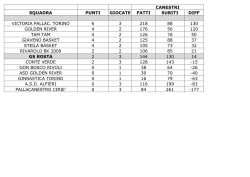
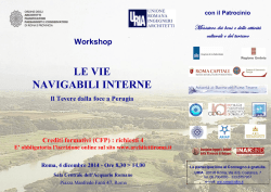
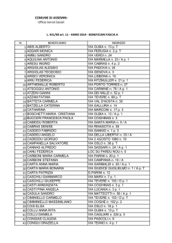
EU Water Framework Directive Implementation
Working Group Action 4.1
Integrated Test in Pilot River Basins
Pilot River Basin:
Tevere River
Autorità di Bacino del Fiume Tevere
Nov 2002
TEVERE PILOT RIVER BASIN - ITALY
WG 4.: 1 Integrated Testing of Guidance Documents in Pilot River Basins
The Tevere Catchment
alluvial structures, supplying a mean discharge of about 9
m3/s; 1 coastal structure.
The Tevere is the largest river basin in central Italy
draining a land area of some 17,500 km2.
It includes parts of the following administrative Regions:
Umbria, Lazio, Toscana, Abruzzo, Marche, EmiliaRomagna.
The city of Rome is located in the lower course of the
Tevere river, near to the mouth. There are several other
towns distributed in the Tevere basin: Perugia, Assisi,
Rieti etc.
Fig. 2: Simulation Model of the flood in Rome (1870)
The Tevere River flow is controlled by several
hydroelectric power stations, the main one of which is
Corbara (near the town of Terni); other hydroelectric
plants are in the main tributary (Nera river).
The river discharges an average of 80 m3 /sec in the
summer and 3500 m3/sec during extra-floodings.
The Tevere River basin is located in central Italy and
belongs to Ecoregion 3 for rivers and lakes and Ecoregion
6 for transitional and coastal waters (Annex XI Directive
2000/60/CE).
Commitment and Resources
The Authority is developing a river basin water
management project scheduled to end 2003. The project
objective is to promote water protection and sustainable
water use at the river basin level. In this context the
integrated testing of Common Implementation Strategy
(CIS) Guidance Documents in the Tevere River basin is
proposed.
Key tasks to be undertaken will include:
Fig. 1: Italy with the Tevere catchment (courtesy of Tevere River
Basin Authority)
The dominant land use is agriculture which accounts for
some 53%, approximately 39% is forested and
approximately 5% is urbanized.
Natural groundwater resources are stored in 27
hydrogeological structures, each may contain one or more
aquifers: 14 carbonatic structures, with about 90 main
springs, localized and linear springs, supplying an average
discharge of about 100 m3/s; 3 volcanic structures, with
springs supplying a mean discharge of about 12 m3/s; 9
-
The implementation of a catchment-wide monitoring
system for the Tevere River basin;
The development of a Geographical Information
System (GIS) for the Tevere River basin;
A programme of public consultation;
The preparation of a river basin management strategy.
Institutional Aspects
The following local, regional and national competent
authorities will be involved in the Pilot River Basins
working group: Ministry of the Environment and Land
Protection, Tevere River Basin Authority, ANPA
(National Agency for the Protection of the Environment),
ARPA (Regional Agencies for the Protection of the
Environment),
Regional
Authorities,
Optimal
Management Area Authorities (ATOs)
•
•
•
NGOs and Stakeholders
•
Local, regional and national competent authorities will
actively participate in the Tevere river basin project.
The Tevere River Basin Authority will organize a working
group in order to coordinate the Guidance Documents
testing. It will be composed of members from the
following organizations: Ministry of the Environment and
Land Protection, Regions comprising the Tevere River
Basin and members of the Institutional Committee of the
Tevere River Basin Authority (Lazio, Umbria, Toscana,
Abruzzo), ARPA (Regional Agency for the Protection of
the Environment), ANPA (National Agency for the
Protection of the Environment), ISS (Superior Health
Institute), IRSA (Water Research Institute), ICRAM
(Italian National Institute for Research Applied to the
Sea).
•
•
•
•
•
Project 2.2 - Guidance on the designation of heavily
modified waterbodies;
Project 2.3 – Guidance on the classification of inland
surface water status and reference conditions;
Project 2.4 – Guidance on the development of
typology and classification systems of transitional and
coastal waters;
Project 2.5 – Guidance for establishing the intercalibration network and inter-calibration exercise;
Project 2.6 – Guidance on economic analysis;
Project 2.7 – Guidance on monitoring;
Project 2.8 – Guidance on tools for the assessment
and classification of groundwater;
Project 2.9 – Guidance on best practice in River Basin
Planning;
Project 3.1 – Development of a common GIS system
Contacts:
Ministry of the Environment and Land Protection
Giorgio Pineschi
Address: Via Cristoforo Colombo 44,
00147 Roma – ITALY
Tel 0039 06 57225153
Fax 0039 06 57225193
E-mail : [email protected]
[email protected]
Tevere River Basin Authority
Alfredo Di Domenicantonio
Address: Via Bachelet 12,
00100 Roma – ITALY
Tel : 0039 06 49249240
Fax : 0039 06 49249300
E-mail : [email protected]
Fig. 3: Peschiera Spring (courtesy of ACEA-ATO2)
Public consultation and participation by local
stakeholders, including NGOs, are seen as key
requirements for the successful implementation of the
Tevere River Basin Project.
Guidance Documents
It is envisaged that the following guidance documents will
be tested in the Tevere Pilot River Basin:
•
Project 2.1 - Guidance on the analysis of pressures
and impacts;
3
© Copyright 2026 Paperzz