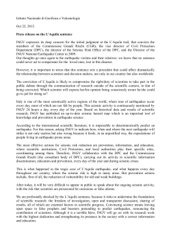
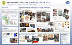
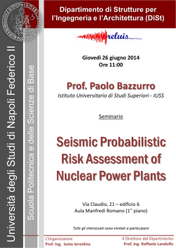
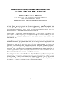
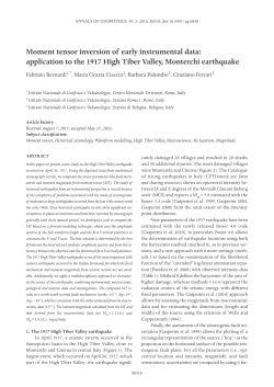
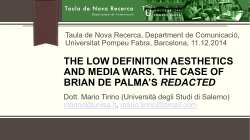
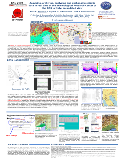
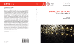
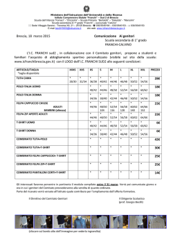
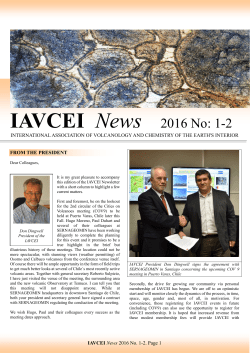
ANNALS OF GEOPHYSICS, 55, 3, 2012; doi: 10.4401/ag-5529
Memories of the past contribute to prevention:
photography as a direct means for public understanding of science
Caterina Piccione
Istituto Nazionale di Geofisica e Vulcanologia, Rome, Italy
Article history
Received December 21, 2011; accepted January 26, 2012.
Subject classification:
Memories, Prevention, Historical images.
ABSTRACT
it is also thanks to these texts that we can reconstruct the
history of the Earth, and in particular, the history of its
volcanoes and earthquakes.
Man has always tried to describe what happens during an earthquake and to document the power of volcanic
eruptions, their effects, the tragedies of the victims and
survivors, the difficulties of reconstruction, and all of the
steps of these natural events, almost wanting to leave a
constructive witness of what they have observed.
While this applies to our entire Planet, in Italy, the
immense archives of writings and testimonies of the past
have allowed scholars to understand the series of volcanic
eruptions and earthquakes over the centuries. This is information that is of vital importance for Italy, whose territory is characterized by areas of high seismic risk, and
by the presence of numerous active volcanoes. Due to this
great availability of material, the work of researchers,
however, has had to cope with the need to achieve scientific reconstruction of events, while in the tales of past
memories, technical data and timely observations have
very often become mixed with partial, inaccurate, and
sometimes fanciful, reports.
Since antiquity, there have been reconstructions of
extreme natural events that have generated many doubts,
as well as other writings representing, in some ways, the
basics of seismology and volcanology. However, it was
with the advent of communication by images that the
tales of disasters took on a central and objective role for
the world of scientific research. Photographs have the ability not to modify what they represent: as it was not possible to manipulate photographs, those who saw them
could draw a full, objective interpretation, which provided
conclusive evidence of understanding about what they
represented.
Vintage photographs become extraordinarily sharp
tools in the hands of researchers, as precious testimonies
of past events, where their analysis is fundamental to the
There are thousands of ways to achieve a sustainable future for our
Planet. Some of these follow high-value scientific research activities,
while others simply aim to increase people’s awareness of what can
and should be done to improve our, and our children’s, quality of life.
The easiest way to develop this specific kind of ‘spread of culture’
consists of bringing back to life what was preserved of the history of
a population and of a territory, by representing it in a renewed form,
and by making it ‘food for thought’. The Istituto Nazionale di
Geofisica e Vulcanologia (INGV) followed this approach and decided
to publish two volumes where the objective was to make people more
aware of the geological and volcanic risks in some specific areas of
Italy. The immediacy of the photography is used to tell the stories of
volcanoes and earthquakes, to represent past events that have become
‘memories’. and to use these as a basis to build a better future.
Terremoto Calabro Messinese, 1908/2008 and Terre di Fuoco
are the two photographic books that have been published by INGV in
cooperation with Alinari, the oldest firm in the world in the field of
photography and image communication. The photographs selected to
be included in the two books had a double significance: on the one side,
they had to convey to the reader the immediacy of the emotions that
other people had felt and lived; and on the other side, they had to make
people understand the importance of prevention. The fascination of
history, the importance of memories of the past, and the extraordinary
strength of images help the reader build a link between the past, the
present and the future, where the lessons learnt from past centuries and
from the study of the Earth and its energy help us to understand which
steps should be taken to achieve a ‘sustainable’ future.
1. Introduction
Volcanic eruptions and earthquakes have always accompanied man over the centuries. As manifestations,
sometimes extreme, of the internal dynamics of our
Planet, they have been the subject of stories and documents of extraordinary quality. Indeed, the numerous testimonies, as well as their historical and literary value,
represent an immense heritage for scientific research, and
427
CATERINA PICCIONE
Figure 1. Left: Cover of Terremoto Calabro-Messinese 1908/2008. The clock of the Messina Central Post Office marks the time of the big shock: 5:21
am. Right: Cover of Terre di Fuoco. The explosive summit eruption of Etna seen from the Greek theater in Taormina (ca. 1880-1890), with the
formation of an eruptive column.
understanding of the status quo and to the formulation of
future scenarios. Indeed, photographs, as well as films, reduce, often to zero, the work of interpretation that researchers are called to play in the analysis. Due to the
immediacy and accuracy of what pictures tell, the ‘memory’ becomes clear and translates into a suitable instrument for every use, from scientific to informative.
By looking at these photographs, every reader can find
a source for reflection: from researchers, who find materials to improve their knowledge of a phenomena and their
studies, to simple citizens, who have the ability to see the reality of the events that changed the history of some parts of
their territory. This process is seen in the choice of the Istituto Nazionale di Geofisica e Vulcanologia (INGV; Italian
National Institute of Geophysics and Volcanology) to publish two volumes that through their vintage photographs
tell the story of the Sicilian volcanoes and the tragedy of
the earthquake that devastated the Messina and Reggio
Calabria area 100 years ago. The objective of this work
was the combination of the ‘purity’ of the published photographs and a technical interpretation that was aimed at
providing an explanation of the elements that caused the
disruption of the territory that are still visible nowadays.
Images of past events can transmit a number of lessons to future generations that would otherwise be impossible to learn, and that must be translated into ‘facts’ to
improve the prevention activities needed to avoid the effects of an earthquake or a volcanic eruption. Only with
images can the culture of prevention reach the largest possible audience and the part of the population that is threatened by seismic or volcanic risk, thus increasing their
awareness. Due to these ‘memories’, the world of research can provide useful information to guide future
choice and to orient this towards full sustainability of the
relationships between man and the surrounding environment, transforming even the simple vision of a photograph or a film into a prevention activity.
2. Terremoto Calabro Messinese 1908/2008: the Calabria
and Messina earthquake, 1908/2008: a lesson to be learnt
The images collected by the researchers of the INGV
in the book Terremoto Calabro Messinese 1908/2008 (The
Calabria and Messina earthquake 1908/2008) communicate
a sentiment that is at the same time one of bewilderment
and hope. With surprise, some photographs document
how portions of Reggio Calabria and Messina were almost untouched by the earthquake output, and even
some miraculously intact buildings amidst the complete
collapse of others. Thus, as well as being a depiction of
the ruins, the photographs allow us to see beyond and to
realize that buildings and houses have different damage
types depending on the construction techniques.
The images themselves suggest that instead of talking about a miracle, we should perhaps speak of a wiser
choice of the areas in which it is possible to build, or of a
more conscious design of the seismic characteristics of
the area of the Straits of Messina and Reggio Calabria, or
simply of using better building materials. These demonstrate that there is a better way to build, and therefore this
is a way that buildings should be constructed in areas
where seismic risk is high.
The photographic gallery uses over a hundred shots
to focus on three fundamental moments of the seismic
phenomenon in relation to the life of man: the effects of
the devastation on buildings and the environmental upheaval caused by the tsunami; the rescue process and life
428
MEMORIES OF THE PAST CONTRIBUTE TO PREVENTION
in the camps; and finally the return to normality. The survivors, rescuers and refugees are the
protagonists of the sad rite that lasted for many
weeks and that invariably recurs after each
strong earthquake. It is not trivial to tell what
happened over 100 years ago in the two cities
bordering the Straits through vintage images,
the tragic reminders that evoke a sense of profound loss. In the case of 1908, however, each
frame appears to emerge from a sense of order,
of almost quiet composure against an event of
extraordinary power, where all, Italians and
foreigners alike, worked together with a twofold aim: to save lives and to restore normality. Finally, in the
images with the camps, the tension that arose from the torment
of the tragedy is no more visible:
the scenes of rebuilding ordered
villages and wooden houses with
pitched roof are very different
from the images of the uncompassionate iron encampments of Belice and of Irpinia. The initiatives
of solidarity and the presence of
the most diverse categories of rescuers highlight at the same time
the poverty of means combined
with the absence of strategies, and
the aim to do what was possible
that united the actions of the insti- Figure 2 (top). Messina. The back of the Vittorio Emanuele Theater in Corso Cavour. The most
tutions and the spontaneous ac- significant damage was caused by the collapse of the surrounding buildings. A large opening just
below the roof shows the complicated stage machinery that makes the theater appear to be more a
tions of civil society.
factory or a mill. Figure 3 (bottom). Campo Calabro. A casa baraccata (hut, or shack) built following
As always happens in the case the antiseismic code enforced by the Bourbon administration after the large 1783 Calabrian
of large earthquakes, the seismic earthquakes. The building that was supported by a wooden frame tightly connected to the masonry
phenomenon surpasses its physical walls suffered minor damage.
nature and becomes as well a social, cultural and administrative phenomenon, an event of
Today, over 100 years later, the dense network of seisgreat historical impact, the moral and material signs of
mic monitoring of the INGV in Italy can locate the epiwhich remain with the territory for several decades. The
center of an earthquake within a few minutes, even if it is
earthquake of 1908 also marked a major turning point for
of very low magnitude, and will understand in real-time
the whole of Italy as a country also from a scientific point
the possible effects in that area. The continuous progress of
of view, with the introduction of seismic classification and
scientific research allows us to update the seismic hazard
the related technical standards for buildings in more and
maps of our territory with increasing accuracy.
more areas of the national territory. Giuseppe Mercalli
was the first to draw up a list of places categorized by in3. Terre di Fuoco: Lands of Fire: the Sicilian volcanoes
tensity grades using his macroseismic intensity scale, to
narrated through images
which he added on this tragic occasion, grade 11: catasWithin its educational activities, the INGV published
trophe. Consequently, Messina and Reggio Calabria bethe book Terre di Fuoco (Lands of Fire), a collection of phocame the symbols of experimentation into seismic
tographs of Sicilian volcanoes. The material used by the
prevention, and at the end of 1909 the country had the
INGV researchers came from the archives of the Alinari of
greatest number of seismographs in the world: this was
Florence and from the Luce Institute, and it covers the pewhen instrumental seismology was born.
riod between the last decades of the 19th century and the
429
CATERINA PICCIONE
In Terre di Fuoco, the images
are arranged according to a path
through time and space, from
which the profound changes to
the territory emerge, both related to the activities of the volcanoes and to the activities of
man. The documentation of
some eruptions is very important; some date back to over a
century ago and show some
specific stages of the eruptive
activity and their effects on the
territory. Pictures tell us how all
the areas at risk close to Etna
and to the islands of Stromboli
and Vulcano were previously
sparsely populated, and the
same pictures also make us understand what the energies of
Figure 4. The Island of Vulcano. The eruption of 1888-1890. November 23, 1888. The initial phase of the
these volcanoes were like at
explosion, known as Vulcanian, from the active cone of La Fossa was described later by Giuseppe Mercalli.
that time, and how they are still
today, and what effects a volcanic
first half of the 20th century. Etna, Vulcano and Stromeruption can have on humans. Indeed, all of the photographs
boli are the protagonists of this volume, and they are
show the human condition before the overwhelming force
chronicled through images that transmit intact to the
of nature. They also show the dynamics that are not too
reader the power of Sicilian volcanoes. The selected imdifferent from those we saw in newspapers during the
ages guide the reader along a path of knowledge of the
eruptions of Etna and Stromboli in recent years. If phoepisodes and places that have always represented a theater
tographs, in their beauty, capture the readers’ attention,
where the stories of volcanic and human events are woven
the captions provide technical and scientific analysis that
into an unbreakable combination that results in the memis capable of making anyone fully understand the activity
ories, a tool of scientific knowledge and prevention that is
of these volcanoes.
essential for the development of a sustainable future, even
During the history of volcanology, the most imporin the areas exposed to severe risk, as that represented by
tant periods were often concurrent with major volcanic
active volcanoes.
eruptions, which stimulated the growth of the scientific
Figure 5. The Island of Stromboli. Left: Paroxysm of October 20, 1950. The eruptive activity continued with an impressive lava flow from the
craters running along the slope of the Sciara del Fuoco, until it reached the sea. Right: Paroxysm of December 28, 2002. A photograph of January
19, 2003, with the lava flow reaching the sea.
430
MEMORIES OF THE PAST CONTRIBUTE TO PREVENTION
community. This was seen in the structure of the Etna Observatory, which was built in 1879 near the crater of Etna,
at 2942 m a.s.l., as a center for astronomical observation.
After a large eruption, the Etna Observatory was completed with a volcanology section dedicated to the observation and monitoring of the volcano. In 1926, the
Observatory became part of the Department of Volcanology of the University of Catania, and in 1933, it became part of the Istituto Vulcanologico (Volcanology
Institute) that was set up within this University. The Istituto Vulcanologico was a modern organization for the
systematic monitoring of active Sicilian volcanoes (Etna,
Stromboli and Vulcano), the activities of which were
based on scientific criteria that are still valid today. It also
led to the creation of the INGV in 1999.
Collezioni Alinari, Firenze: Alinari, Catania: INGV.
Ieni, R., C. Piccione, R. Rasà, A. Tripodo and L. Villari
(1999). Storia eruttiva dello Stromboli e fenomeni correlati dal 1558 al 1996, Laboratorio di Cartografia Numerica dell'Istituto di Scienze della Terra, Università di
Messina, n. 19.
Nave, R., and C. Piccione (2006). Education and information as tool for risk mitigation: the Italian experience in
Neapolitan area and the Aeolian visitors centres, Sicily,
First European Conference on Earthquake Engineering and Seismology, (Geneva, Switzerland); available
at http://hdl.handle.net/2122/2165.
4. Conclusions
The INGV decided to communicate using images
and to bring back to life the memories of the past, by updating them and referring them to its patrimony of knowledge. This knowledge is the result of decades of research
in the seismology and volcanology fields, in order to provide a prevention tool for the populations that live in areas
at risk of earthquakes and volcanic eruptions.
With the effects that they have on the life and property
of man, volcanoes and earthquakes have characterized the
history of mankind, and more particularly, the of Italy.
Knowing the past, acquiring its memory, analyzing and updating it to make it available to the community – this is what
has helped to develop our scientific knowledge up to the current awareness. This development was also due to historical photographs of earthquakes and eruptions, which
remain very important from the scientific point of view.
The charm of history, the importance of memories,
and the extraordinary force of the historical photographs
published by the INGV help the reader to create a strict
link between the past, the present and the future. The
power of images combined with the scientific analysis of
earthquakes and volcanic eruptions offer an important
contribution to the decisions to be taken to plan a sustainable future for those areas that are exposed to seismic
or volcanic risk.
References
Azzaro, R., C. Piccione and G. Valensise (2008). Terremoto Calabro Messinese 1908/2008, Firenze, Alinari
24 Ore.
Bertolaso, G., E. Boschi, E. Guidoboni and G. Valensise,
eds. (2008). Il terremoto e il maremoto del 28 dicembre
1908: analisi sismologica, impatto, prospettive, Bologna,
SGA.
Bonaccorso, A., S. Branca, P. Del Carlo and C. Piccione
(2005). Terre di Fuoco. Etna, Stromboli, Vulcano nelle
Corresponding author: Caterina Piccione,
Istituto Nazionale di Geofisica e Vulcanologia, Rome, Italy;
email: [email protected].
© 2012 by the Istituto Nazionale di Geofisica e Vulcanologia. All
rights reserved.
431
© Copyright 2026 Paperzz