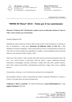
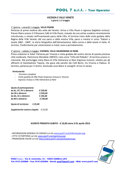
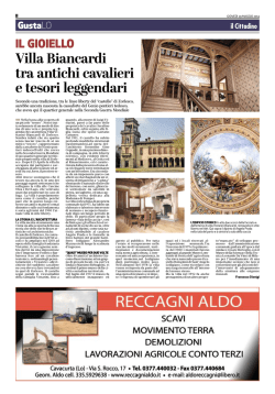
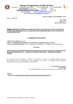
The Journal of Fasti Online (ISSN 1828-3179) ● Published by the Associazione Internazionale di Archeologia Classica ●
Piazza San Marco, 49 – I-00186 Roma ● Tel. / Fax: ++39.06.67.98.798 ● http://www.aiac.org; http://www.fastionline.org
The 2012 Excavation Season at the Villa San Marco, Stabiae:
Preliminary Field Report1
Taco T. Terpstra
In the summer of 2012, Columbia University, in collaboration with H2CU (Centro Interuniversitario per la Formazione
Internazionale) followed up on its successful 2011 pilot season in ancient Stabiae as part of the “Advanced Program of Ancient
History and Art” (APAHA). The Program performs stratigraphic excavations in the Villa San Marco, one of the largest and most
opulent villas in Campania, investigating both the Villa as a Roman elite structure and the pre-79 AD history of the site. The goal
of the excavations is to give a full archaeological account of the stratigraphy from the eruption layers of Mt Vesuvius down to
virgin soil. Building on the results from the previous year, the 2012 campaign had two main research goals: investigating the Villa’s system of water-supply and drainage, and clarifying the Villa’s relationship with the road that marks its northern limit. The
results were on the one hand the discovery of a work area in the northern sector of the Villa, and on the other the clarification of
the temporal relationship between the Villa and the road and a better understanding of the history of the road itself.
In the summer of 2012, the Advanced Program of Ancient History and Art (APAHA, Columbia University) followed up on its successful 2011 pilot season at the Villa San Marco in ancient Stabiae2. Building on the results from
the previous year, the 2012 excavation campaign had two main research goals: investigating the villa’s system of
water-supply and drainage, and clarifying the villa’s relationship with the road that marks its northern limit. To
achieve those goals, the 2012 team excavated below the 79 AD level in two separate areas: inside the villa in room
68 and outside in the street (fig. 1). Both of these areas had been cleared of volcanic material in the eighteenth century; they had then been immediately backfilled, to be re-excavated only in 20083. This report discusses the most
important discoveries of the 2012 campaign.
1. The Trenches in Room 68
To investigate the Villa San Marco’s drainage and water-supply system, the APAHA excavations concentrated on the northwestern and southwestern corners of room 68 (fig. 1). The first corner was of interest to the team
because of the results from the previous season, suggesting the presence of a drain there, the second because of
water features encountered in 2008 that at the time were only partially uncovered, poorly understood, and incompletely published. Central to these features in the southwestern corner is a large, deep channel, circa 60 cm in width,
which in its first phase had walls of a relatively modest height of circa 65 cm. Its incline is gentle, sloping down from
1
The author of the article and the directors of the APAHA, Prof. Francesco de Angelis and Prof. Marco Maiuro, wish to express
their gratitude to the Sovrintendenza per i Beni Archeologici di Napoli e Pompei (dott.sse Teresa Elena Cinquantaquattro, Giovanna Bonifacio, and geometra Vincenzo Sabini) for their support and collaborative efforts, as well as to the staff of the Foundation Restoring Ancient Stabiae (in particular dott. Paolo Gardelli) for their help with the technical, logistical, and practical aspects
of the project. They would also warmly like to thank the Italian Academy at Columbia University and the H2CU consortium
(Università di Roma La Sapienza) for their generous support and sponsorship. In addition, the author wishes to thank the anonymous FASTI reviewers for their helpful comments.
2
TERPSTRA, TONIOLO, and GARDELLI 2011; TERPSTRA 2012.
3
Most of the villa was cleared of Bourbon backfill in the 1950s by D’Orsi (see D’ORSI [1996]); for the 2008 excavations, see
RUFFO 2009; RUFFO 2010.
www.fastionline.org/docs/FOLDER-it-2013-286.pdf
Taco T. Terpstra ● The 2012 Excavation Season at the Villa San Marco, Stabiae: Preliminary Field Report
Fig. 1. Villa San Marco. Trenches with features in room 68 and in the street.
south to north about 13 cm over a distance of 5 m.
At its northern end the large channel turns west at
a 90º angle, running underneath the room’s western wall into the southern latrine. Another short
channel joins the larger channel from the east,
also at a 90º angle. During the villa’s final phase,
the rainwater from the colonnaded open space in
the center of room 68 (room 67) was collected
here and led into the southern latrine and from
there out to the street (fig. 1, fig. 2; see also the
discussion below on the trench in the street). As to
the date of this drainage system, its great depth
and the fact that its walls were heightened twice
suggests it is a relatively early feature, perhaps
contemporary with the villa’s original construction.
It seems likely that this system of drainage channels was more extensive in an earlier phase. It
probably once extended beyond the southern wall
and served to drain waste water coming from
rooms further to the south. An indication that the
Fig. 2. Room 68, southwestern corner. Drains, shallow basin of work area.
drain did not originally start at the southern wall as
it does now is a cut in the channel floor about 15 to 25 cm from the wall, which can only have been created by cutting the drain from the south and then blocking it up. The short section of lead water pipe sticking out of the wall (fig.
2; see discussion below) seems to belong to this blocking event as well. By the same token, it seems that the short
drain coming from the east also originally extended further, and was subsequently cut and blocked. The large width
and depth of this section seems unjustified by its use as a drain for rainwater from the colonnaded open space
(room 67), a space that, moreover, the results from the previous season had already shown to be a late architectural
addition. We should therefore probably imagine that what is left now are the remnants of a more extensive drainage
system, in its original shape coming into the room from further south beyond the southern wall, and with a branch
joining it from further east beyond the colonnaded open space.
The walls of the large drain were raised twice, both times associated with floor-raising events. The second
reconstruction happened at a greater width of 80 cm, which created ledges to support a covering of ceramic tiles
and other building material such as bricks and a fragment of undecorated white marble revetment, all set into a thick
2
www.fastionline.org/docs/FOLDER-it-2013-286.pdf
Taco T. Terpstra ● The 2012 Excavation Season at the Villa San Marco, Stabiae: Preliminary Field Report
layer of cement (figs. 2 and 3). However, this material appeared
not to rest directly on the ledges running along the channel’s
length but to “float” about 5 cm above them on both ends,
touching only the channel walls (fig. 3). This suggests that the
lower part of the original roof was constructed in wood that has
now decayed, leaving a void. With these rebuildings the channel walls reached the considerable height of 140 to 160 cm,
with the inside height of the channel at ca 95 cm. However, the
channel walls were never replastered and always remained
covered only up to a height of about 30 cm from the bottom (fig.
3), so the raising of the channel walls seems not to have been
intended to increase the drainage capacity of the feature. Instead, the reason seems to have been a desire for access, perhaps for cleaning purposes; at the point where the channel
makes its 90º turn west towards the southern latrine, there is a
rectangular shaft measuring around 50 by 40 cm and leading
straight down into the channel. The shaft was covered by a
roughly-cut and badly-fitting capstone, which was found in situ
by the 2008 team. This shaft and capstone show that access to
the inside of the drain was considered important during the final
phase. After the height of the large channel had been raised
twice, a narrower channel (circa 25 cm in width, 53 cm in height
on the inside) was added, leading from the atrium (room 44)
through the southern wall, and joining the wider channel at an
oblique angle to drain the atrium’s rainwater (figs. 1 and 2). This
event seems to be contemporary with a more comprehensive
restructuring of the southern end of the large channel, which
Fig. 3. Room 68, southwestern corner. Large drain.
was probably cut and blocked at this time, creating the cut in
the channel floor ca 15 to 25 cm from the southern wall,
mentioned above. Almost certainly, this event is associated with the construction of the outdoor swimming
pool on the other side of the wall (room 42a). The
large drain’s floor is at approximately the same level
as the floor of the swimming pool, which explains why
the drain had to be cut when the pool was dug. However, a direct connection between the pool and the
drain seems to have been created by a section of lead
water pipe, running through the southern wall and
serving as a drain for the pool. A drainage hole can be
seen at the bottom of the pool, roughly at the level of
the fistula on the other side of the wall. However, at
the bottom of the channel, the fistula was found completely buried within a layer of sediment on the channel floor, so if the fistula did indeed serve to empty the
pool, by 79 AD this had not happened for probably a
considerable length of time.
The large channel served a work area consisting
of
a
triangular cistern supplying water, a basin with
Fig. 4. Room 68, southwestern corner. Work area: triangular cistern,
a
work
surface,
and a chute to drain the waste water;
shallow basin with work surface, chute, and drain.
a hole in the basin’s southeastern corner connects it to
the chute (fig. 4). Originally 110 cm in height, the basin was subsequently made much shallower, around 20 cm in
height; so shallow in fact that it seems hard to conceive of any practical use. The waste chute as well had been
modified at least once with the placement of two roughly-cut stones forming a “bridge” over the channel. These
stones are certainly a later addition, resting as they do upon a layer of waterproof plaster; they seem to have been
intended to reduce the size of the chute. In 79 AD, the chute was no doubt open, which is the reason why the channel was discovered filled with volcanic material. North of the chute though, the channel was probably completely
covered by the tiles and cement described earlier, a remnant of which can be seen in figs. 2 and 3. However, much
of the covering had been destroyed by the Bourbon excavators in the process of extracting lead pipes, which
3
www.fastionline.org/docs/FOLDER-it-2013-286.pdf
Taco T. Terpstra ● The 2012 Excavation Season at the Villa San Marco, Stabiae: Preliminary Field Report
Fig. 6. Room 68, northwestern corner. Destroyed tank (shape marked with red
lines) and drain.
explains why the channel was seen during the excavations in
2008 led by Fabrizio Ruffo4. It seems likely that at roughly the
same time the work area was restructured, the drain section coming from the east was cut and blocked, coinciding with the conFig. 5. Room 68, northwestern corner. Drain, destroyed
tank, foundation of northern wall intruding into tank.
struction of the colonnaded open space 67 in the center of the
room.
During the final phase of the villa, a number of water pipes were present in the southwestern corner, coming
from the north and branching off south and west in at least three different directions: one leading underneath the
threshold of the southern latrine towards the bathing complex, one going into the latrine wall and feeding the triangular cistern of the work area5, and one crossing the large channel, leading through the southern wall to the swimming
pool (room 42a) on the other side. With regard to this last fistula branch, traces of Bourbon robbing are clearly visible
on both sides of the wall, with a hole punched all the way through it (repaired with tufa blocks in modern times).
Without much doubt, in the last phase of the villa the fistula originally present here fed the swimming pool, perhaps
through an ornamental water spout, removed in the eighteenth century along with the lead pipes6.
In the northwestern corner of room 68, a large channel was discovered, the continuation of the feature found
last season (fig. 5)7. This channel runs into the northern latrine underneath the threshold, leaving no doubt about its
use as a drain. Its incline is much steeper than that of the drain in the southwestern corner: around 27 cm over a
span of 4.5 m. This drain had also been disturbed by the Bourbon excavators; its roof and walls had been partly destroyed, and the inside was filled with modern backfill. The explanation for this disturbance is the robbing of the water pipe that must have lain at the bottom of the channel. The results from the 2011 APAHA season had already
shown that during the Villa’s final phase a fistula entered the room from the street, turning west from the entrance
and running along the northern wall8. The 2012 results show that this pipe then turned south, running along the latrine wall towards the room’s southwestern corner. In the relatively narrow passageway between the corner of the
colonnaded open space (room 67) and the northern wall, the drain and the fistula joined, the pipe running through
the drain for a short section of about 3.5 m. The fistula seems to have entered the drain from the northeast, exiting it
again to the southwest, which is why the drain’s walls and roof between those points were destroyed by the Bourbon
excavators (figs. 5-6).
4
See RUFFO 2009: 237, fig. 1 (where the water features are partially drawn in), and 247. On the Bourbon excavations in the villa,
see ALROGGEN-BEDEL 1999. See also FERRARA 2001.
5
See also TERPSTRA 2012 with fig. 4
6
Unfortunately, D’Orsi’s journal does not tell us what situation the excavators encountered here in the 1950s. D’Orsi started
clearing the room in May 1954, but work seems to have continued at least until the fall of 1958. The report shows a lacuna for
that last period, and all we have are the laconic notes by D’Orsi’s assistant, Vicenzo Cuccurullo. The last, brief mention by
Cuccurullo of excavations in room 42 dates to September 6th, 1958. See D’ORSI 1996: 177 ff., 296, 480.
7
See TERPSTRA 2012: 9-10 with figs. 18-19.
8
See TERPSTRA 2012: 6-7 with figs. 11-14 for the evidence for robbed fistulae in the Villa San Marco.
4
www.fastionline.org/docs/FOLDER-it-2013-286.pdf
Taco T. Terpstra ● The 2012 Excavation Season at the Villa San Marco, Stabiae: Preliminary Field Report
A significant discovery of the 2012 season is that
the northern wall bordering the street was built in two
phases; the current wall in opus reticulatum is not the
original division wall but is constructed following the same
alignment of an older one. The evidence for this restructuring is provided by the foundation for the current wall,
which intrudes into a disused and mostly destroyed triangular tank (figs. 5-6). This tank was built up against the
older wall and partially on its foundation. Although it is
unclear what this tank was used for, the nature of room
68 as a servile or work space coupled with the evidence
for a work area in the southwestern corner strongly suggests productive use of some sort. When the current
northern wall was constructed, the tank was destroyed.
The final construction event is represented by the colonnaded open space (room 67) in the center of room 68.
The northwestern pier of this space uses the southern
corner of the destroyed triangular tank as its foundation,
while the brick column built up against the northern wall
rests upon the northeastern corner of the tank (fig. 6). The
surface of room 68 was subsequently raised with a layer
of beaten earth. In the northwestern corner, on top of this
final floor surface, clearly distinguishable burn marks were
found along the northern wall. Whether these marks are
ancient or Bourbon could not be determined with certainty, although their awkward position in a narrow passageway and their proximity to an eighteenth century robber
trench makes the latter possibility perhaps more probable.
To sum up, the main events seem to have been:
the construction of a wall separating the street from the
villa; a first phase with a work area in room 68, which
probably occupied both its northwestern and southwestern corners; a second phase with the work area in the
northwestern corner going out of use with the construction
Fig. 7. Room 68, northwestern corner. Limestone mortar.
of a new northern wall, and the one in the southwestern
corner being restructured. The cumulative evidence of the
southwestern and northwestern corners seems to suggest that room 68 was, at least partially, used for productive
purposes of some sort9, a hypothesis supported by the presence of a conical, limestone mortar of around 54 cm in
height and 61 cm in maximum diameter, found in 2008, standing up against the northern wall (fig. 7).
2. The Trench in the Street
The trench in the street provided the APAHA team with the opportunity to answer questions resulting from
the last season about the course of the Villa San Marco’s drainage system, but also about the chronological relationship between the street and the Villa. We aimed to establish whether there is evidence for earlier road surfaces
and whether there is evidence for earlier villa architecture, suggesting the Villa San Marco predates the road and
was cut by its construction. To answer those questions, the trench spanned the full width of the street between the
wall to the south, which belongs to the Villa San Marco, and the wall of the neighboring villa to the north10. In that
last wall, there is a rectangular cut, initially hypothesized to be a doorway leading from the street into the villa (figs.
1, 8). The trench was placed to include this cut so as to investigate its nature and its relationship to the street, and to
investigate its possible association with an earlier road surface.
9
The discovery that room 68 was essentially a work space makes the interpretation put forward by Domenico Esposito of the
Villa San Marco as a praedium imperiale less plausible, in my view. It also makes it unlikely that the lack of decoration in room 68
has anything to do with a “situazione evidente di lavori in corso rimasti incompiuti a seguito dell’eruzione”, ESPOSITO 2011: 144.
10
On the villa across the street from the Villa San Marco, see ESPOSITO 2011: 144-152; RUFFO 2010.
5
www.fastionline.org/docs/FOLDER-it-2013-286.pdf
Taco T. Terpstra ● The 2012 Excavation Season at the Villa San Marco, Stabiae: Preliminary Field Report
Fig. 9. Street. Southern section with drain.
In this trench the APAHA team reached a layer of natural deposits for the first time. This consisted of a yellow
paleosol stretching throughout the length of the trench (fig. 8).
In the southernmost part of the trench the layer of paleosol
Fig. 8. Street. Layer of yellow paleosol, Bourbon robber hole.
sloped down steeply north to south; its deepest level was
reached at just over 2 m down from the 79 AD road surface (fig.
9). This steep slope could be the result of the natural shape of the paleosol, but could equally well be the product of
a quarrying event. The natural layer is probably the result of an earlier eruption of Mt Vesuvius, and is visible also in
the villa across the street. A section of the western substructure of that building has collapsed and slid down the hill,
exposing the same paleosol; the exposed sections created by the collapse show that this layer is at least a meter
thick. In the APAHA trench, the space created by the steep downward slope of the paleosol was filled with a layer of
dark soil containing relatively little cultural material. Apart from some ceramic sherds, this layer contained bigger and
smaller chunks of soft lavastone as well as a large number of rooftile fragments. A preliminary study of the ceramics
(which included a fragment of blackfigure ware) and the rooftiles suggests the layer is early in date, belonging roughly to the sixth century BC11.
The trench did not produce traces of older villa architecture. An important conclusion from the 2012 season
is therefore that in all likelihood, the street predates the villas rather than the other way around. A path or road leading from the coast up to Stabiae likely existed before the villas did, and the villas were subsequently built lining this
path. However, this road was probably no more than a dirt track worn into the paleosol. No evidence has been discovered by the APAHA team to suggest habitation postdating the sixth century BC but predating the construction of
the Roman villas. The results from the 2012 season are thus in line with the hypothesis developed last season: in
the investigated area, sixth-century BC activity was probably followed by centuries of inactivity and abandonment, in
turn followed by a rapid succession of construction events associated with the villas, starting perhaps around 100
BC12.
The only feature in the trench in the street consisted of a large drain, the top of which can be traced in the
road, running down east to west along the Villa San Marco’s northern wall (fig. 1). It was constructed by digging a
trench through the soil and then building the drain’s walls contra terra; the outside face of the drain, consisting of soil
mixed with cement, was excavated in the hope of finding datable ceramics (still under study), exposing the wallface
11
Compare the layer discovered last season in room 68: TERPSTRA 2012: 3, figs. 5-6. Much of our evidence for the earliest phases of the Stabian settlement comes from the necropolis at Madonna delle Grazie, discovered in 1957; SENATORE 2001: 23-26.
See also D’Orsi’s journal; D’ORSI 1996.
12
Other evidence suggests that the settlement of Stabiae witnessed a more or less steady development from about the 6th c. BC
onward, so if this hypothesis is correct then the development of this part of the Stabian plateau would have differed from the rest.
See SENATORE 2001: 23-28.
6
www.fastionline.org/docs/FOLDER-it-2013-286.pdf
Taco T. Terpstra ● The 2012 Excavation Season at the Villa San Marco, Stabiae: Preliminary Field Report
with cement, soil, and pebbles visible in fig. 9. It seems likely that the drain, when first constructed, was not completely buried, but stuck out above the road surface. Its top section of about 40 cm of cement is smooth and flat, and
seems to have been poured against wooden planks rather than soil. The team did not investigate the inner channel,
but the drain’s outside dimensions are circa 85 cm in width, 120 cm in depth. Through a hole in the Villa San
Marco’s northern wall, this drain was fed by the wastewater coming from the latrines. The sewage from both large
channels in room 68 described above as well as the rainwater from the colonnaded open space (room 67) and the
atrium (room 44) thus ultimately ran through it13. It seems likely that the drain was constructed at the same time as
the Villa San Marco, or shortly afterwards; if indeed the large drain in the southwestern corner of room 68 is more or
less contemporary with the construction of the Villa, then the streetside continuation of the drain likely dates to the
Villa’s first construction phase as well. After the walls of the villas lining the street went up, the road surface seems
to have been raised incrementally until it became level with the top of the drain.
The wall of the villa across the street had no foundation trench and seems to have been built up against the
paleosol as a retaining wall, the floor inside the villa being considerably lower than the street level. The rectangular
cut connecting the street and the vaulted substructures inside turned out not to be a doorway created in antiquity.
Removal of soil exposed it completely, and no signs of a threshold or steps were visible; instead, the lower half appeared to be roughly cut (fig. 8). In addition, no evidence was found to suggest that the passageway was associated
with an older road surface. The most likely explanation is therefore that it is a Bourbon robber hole, created by cutting through the wall from inside the villa. its sunken position is a product of the lower floor level of the villa, meaning
the Bourbon excavators were forced to dig a cavity in the street at the point where they exited the wall.
To sum up, the main events in the street seem to have been: a possible quarrying event followed by a sixth
century BC fill or leveling event; the emergence of a path (probably leading from the sea to the settlement of early
Stabiae) followed by the construction of two Roman villas with a proper road surface in-between.
Taco T. Terpstra
E-mail: [email protected]
BIBLIOGRAPHY
ALLROGGEN-BEDEL A., 1999, “Gli scavi borbonici nella villa S. Marco e le pitture staccatevi nel settecento”, in A. BARBET, P. MINIERO (eds.), La villa San Marco a Stabia. Naples, Rome, Pompei: 21-40.
D’ORSI L., 1996, Gli scavi di Stabiae: Giornale di scavo (con appendice di Vicenzo Cuccurullo; a cura di Antonio Carosella), Rome.
ESPOSITO D., 2011, “Su un possibile praedium imperiale a Stabiae”, in Oebalus: Studi sulla Campania nell’Antichità
11: 143-163.
FERRARA A., 2001, “La Villa San Marco a Stabiae”, in D. CAMARDO, A. FERRARA (eds.), Stabiae dai Borbone alle ultime scoperte, Castellammare di Stabia: 99-104.
RUFFO F., 2009, “Sulla topografia dell’antica Stabiae. Osservazioni sulla Villa San Marco e sul cosiddetto impianto
urbano alla luce delle recenti indagini archeologiche (2008-2009)”, in Oebalus: Studi sulla Campania
nell’Antichità 4: 235-271.
RUFFO F., 2010, “L’insula sudoccidentale del cosiddetto ‘impianto urbano’ di Stabiae. Nuovi dati dalla recente campagna di scavo (2009)”, in Oebalus: Studi sulla Campania nell’Antichità 5: 177-239.
SENATORE F., 2001, “Stabiae: storia dell'insediamento”, in D. CAMARDO, A. FERRARA (eds.), Stabiae dai Borbone alle
ultime scoperte, Castellammare di Stabia: 23-38.
TERPSTRA T.T., TONIOLO L., and GARDELLI P., 2011, “Campagna di scavo APAHA 2011 a Villa San Marco, Stabiae:
relazione preliminare sull’indagine archeologica”, in Rivista di Studi Pompeiani 22: 199-205.
TERPSTRA T.T., 2012, “The 2011 Field Season at the Villa San Marco, Stabiae: Preliminary Report on the Excavations”, in Fasti Online Documents & Research No. 259.
13
See also RUFFO 2009: 258; RUFFO 2010: 196. Note that the sewage from the Villa San Marco’s latrines was not channelled
through the hole in the wall shown in RUFFO 2010: fig. 12; in reality, the sewage exited the Villa further east where the latrines are
(the hole shown by Ruffo probably served to drain rainwater coming from the Villa’s roof, as did the groove in the bottom step of
the staircase).
7
www.fastionline.org/docs/FOLDER-it-2013-286.pdf
© Copyright 2026 Paperzz