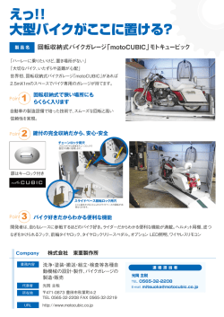
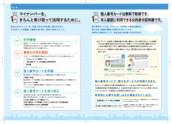
PointCloud テクニカルインフォメーション
下記ページにてPointCloudの機能情報などをご案内します。
お問い合わせは、Kubit Japan: http://jp.kubit-software.com/ のお問い合わせページからご連絡下さい。
Q1 PointCloudについて
Q2 PointCloudがサポートしているAutoCADのバージョン
Q3 サポートしている3Dレーザースキャナーの種類
Q4 PointCloudで使用できる画像データ
Q5 3D描画について
Q6 点群保存について
Q7 セクションマネージャー
Q8 PointCloudの素早いレスポンス
Q9 “SendToKubit”機能の利点
Q10 PointCloud “Free Edition”について
Q11 PointCloud 試用版について
Q12 PointCloud と PointCloud Pro の機能
Software for Surveying, Construction and Architecture
kubit GmbH
Fiedlerstr. 36, 01307 Dresden, Germany
Fon +49 351 41767-0 Fax +49351
41767-29
Email [email protected]
Web www.kubit-software.com
Q1 PointCloudについて
PointCloudとは、膨大な3次元レーザー点群をAutoCAD環境においてビジュ
アル化と分析をサポートするためのソフトウェアです。 産業用構造物、歴
史的建造物、彫刻などの図面化により、全レベルの詳細を記録することが
できます。 点群にCAD図面、写真、フロア計画などのほかの情報を組み合
わせることもできます。 3次元レーザースキャナーで読込まれた何百万も
の点群はAutoCADの2次元、3次元機能を利用して効率的に処理することが
できます。AutoCAD機能の“Object Snap”を使い、全てのシングル点と3次
元座標にアクセスすることができます。全てのAutoCADコマンドとアプリ
ケーション機能はスキャンされたオブジェクトについて正確なジオメトリ
を持っています。
Q2 PointCloudがサポートしているAutoCADのバージョン
PointCloudは、Architectural Desktop, AutoCAD Map, Civil3D, Plan3DのようなさまざまなAutoCADアプリケーションで
AutoCAD2007 – 2011(32bitと64bit両方)がサポートされています。
Q3 サポートしている3Dレーザースキャナーの種類
ほとんどのレーザースキャナーがASCIIファイルフォーマットにエクスポートすることができます。PointCloudは、そのASCIIファ
イルからPointCloud点群ファイル(*.PTC)またはAutoCAD点群ファイル(*.PCG)を作成しAutoCADにインポートすることができ
ます。PTCファイルにエクスポートすることができるスキャナー独自のソフトウェアは下記の通りです:
・FaroScene (FARO)
・llris3D-Parser (Optech)
・RiScanPro (Rieg) LMS
・LaserControl (Zoller&Frölich, Leica HDS4500/6000)
・Scan Master (Topcon)
・Polyworks (Inovmetric)
・ Pointools (pointools)
・JRC 3D Reconstructor (Gexcel/Topotek)
・ LupoScan (Lupos3D)
・RealWorksSurvey (Trimble)
・Scan Manager (3D Scanline)
さらに、RiSCAN PROプロジェクトとLeica HDS PTZファイルはPointCloudバイナリーデータフォーマット(*.ptc)またはAutoCAD
点群ファイル(*.pcg)に変換でき、AutoCADに直接インポートすることができます。PTZファイルは下記ソフトウェアで作成可能で
す:
・Cyclone Register
・Cyclone Viewer Pro
Q4 PointCloudで使用できる画像データ
PointCloud はイメージの高解像度情報と同時に点群の 3 次元情報のポストプロセスに機能性を与えます。このために PointCloud
は特別なインポート機能を提供します。RealWorks Surey (Trimble) , JRC 3D Reconstructor (Gexcel/Topotek)または RiSCAN PRO
(Riegl LMS)を用いて作成したオルソ写真は図面の正確な位置に直接インポートすることができます。
さらに、PointCloud Pro は RiSCAN PRO (Riegl LMS)または Reconstructor (JRC/Topotek, ORI image files)で作成された標定写真
を AutoCAD の中に直接インポートすることができます。また、PointCloud Pro には画像標定の機能があります。画像標定は、同
時に 3D(計測されたコントロールポイント)から一致する 2D(画像)点に外部と内部カメラパラメーターを決定します。標定画
像は 3D 描画に使用することができます:
1.
標定画像とサーフェースを用いて 3D 描画
2.
複数の標定画像を用いて 3D 描画
Q5 3D描画について
標定画像とサーフェースを用いて 3D 描画:
ユーザーは標定画像にある点をクリックします。選択されたサー
フェース(点群、面、シリンダー)でクリックされた点の投影線
の交点が計算されます。最初に交差したサーフェースで 3D 点は
前定義された AutoCAD コマンドに戻ります。
複数の標定画像を用いて 3D 描画:
ユーザーは異なった標定画像で二つの対応する点をクリックし
ます。交点は計算され現在走らせているコマンドに戻ります。
Q6 点群保存について
ASCII ファイルは PTC ファイルにインポートすることができます。ASCII ファイルに比べて PTC ファイルの扱いはとてもコンパ
クトです。PTC ファイルは必要な点をすぐに表示することができるので ASCII ファイルよりも早く読込むことができます。PTC
ファイルは AutoCAD 図面で参照されるので図面のサイズは増加されません。
PointCloud は AutoCAD 点群ファイル(*.pcg)もサポートしています。インポートされたスキャンフォーマットは PCG または PTC
フォーマットを選択して保存することができます。PCG フォーマットは AutoCAD 2011 を始める Autodesk によって実現されま
した。このフォーマットは、大量の点群作業に可能性を与え、より優れたディスプレイパフォーマンスを提供します。
Q7 セクションマネージャー
必要な部分の点群(例:パイプなど)をカラーリング、表示/非表示にすることができます。それは効率良く点群作業をするため
にセクションで分け、管理することができるセクションマネージャーです。スキャンされたオブジェクトのすべての情報が必要で
はない時、必要な部分をモデリングするのにとても便利です。必要な情報を選択した可視部分はボックス、スライス、ポリゴンと
して定義することができます。さらに、すべての点群から可視部分に減少させることもできます。それは不適切または必要のない
点群を削除し多くのメモリを利用可能にし、新しい点群(ptc ファイルまたは pcg ファイル)を生成することができます。
Q8 PointCloudの素早いレスポンス
高パフォーマンスのための最も重要な理由はとてもシンプルです。実際に見えるそれらの点だけを表示します。この非常に簡単で
効率的な原理には高性能な計算が必要です。それらは点群が 3000 万点あっても 70 万点(1024×768)が最大数です。このため、
PointCloud は常に正確な描画指示で点を表示していて、バックグラウンドにある点は表示されません。
AutoCAD 点に対して PointCloud 点は非常に軽いです。AutoCAD 点にはレイヤー名や点スタイルなどのような追加情報がありま
す。PointCloud にあるデータは、パフォーマンス増加とメモリ空間保存のためにこの情報の全てがありません。たとえ点群がシン
グル AutoCAD 要素(カスタム・エンティティー)でもユーザーは点群のあらゆるシングル点にアクセスすることができます。オ
ブジェクトスナップ“point”がサポートされ、データ(ポリライン描画、寸法など)の共通処理をすることができます。
3D オービットを実行中、素早い回転とナビゲーションのために点群は間引かれます。
Q9 “SendToKubit”機能の利点
PointCloudには外部プログラムから座標をAutoCAD/PointCloudに送るライブラリー(SendToKubit)があります。
アプリケーションは多くのスキャナーメーカーによって与えられたビューワーソフトで直接点群をデジタル化します。
“SendToKubit”は下記のソフトウェアシステムに提供されています:
このフォーマットは、大量の点群作業に可能性を与え、より優れたディスプレイパフォーマンスを提供します。
• FaroScene (FARO)
• JRC Reconstructor (Gexcel/Topotek)
• RiSCAN Pro (Riegl LMS)
• LupoScan (Lupos3D)
• PlanarView (kubit)
Q10 PointCloud “Free Edition”について
FreeEdition は AutoCAD 2011 以上のために提供され、PointCloud のライセンスは必要ありません。
簡単に標準セットアップをインストールでき、ASCII, Riegl, Leica などのようなさまざまなスキャンデータを PCG または PTC フ
ァイルとしてバージョン 2011 以上の AutoCAD にインポートすることができます。インポートされた全ての点は AutoCAD オブジ
ェクトスナップ(OSNAP)を使うことができます。FreeEdition は無料で提供しているため、インポート以外の PointCloud コマ
ンドを使用することができません。AutoCAD での点群データのインポートは FARO と LAS ファイルに制限されていますが、
FreeEdition を使うことによって、他のスキャンデータを AutoCAD にインポートすることができます。
Q11 PointCloud 試用版について
PointCloud には全ての機能をお試しいただける試用版があります。
試用版のお申込みにつきましてはウェブサイト Kubit Japan: http://jp.kubit-software.com/ から、または直接お問い合わせください。
Q12 PointCloud と PointCloud Pro の機能
PointCloud
FEATURE LIST
PointCloud
Pro
Insert point cloud
x
x
Set current point cloud
x
x
Set point cloud parameters (average distance, noise)
x
x
Set preferred point cloud format
x
x
Load point cloud
x
x
Unload point cloud
x
x
Merge point clouds
x
x
Crop point cloud
x
x
Set grip position
x
x
Settings for display performance
x
x
Manage kubit point clouds (PTC)
Show/Hide Bounding Box of point clouds
x
x
Show/Hide grip of point clouds
x
x
Modify point size
x
x
Convert kubit point cloud to AutoCAD point cloud
x
x
Reindex AutoCAD point cloud
x
x
Set point density for modeling tools
x
x
Optimize display
x
x
Import point cloud (ASCII)
x
x
Import Leica HDS PTZ files
x
x
x
x
Manage AutoCAD point clouds (PCG) [AutoCAD 2011 and higher]
Import
Import Riegl RiSCAN Pro rsp - project
file - point cloud
-oriented image
x
-orhto image
x
x
Reconstructor - import orhto image
x
x
Trimble RealWorks Survey - import ortho image
x
x
x
x
Shift slice
x
x
Change slice thickness
x
x
Define multiple slices - parallel to UCS planes
x
x
x
x
Define clipping box
x
x
Define section inside a polygon
x
x
Define section outside a polygon
x
x
Restore previous section definition
x
x
Section manager - show/ hide sections
x
x
-create new sections
x
x
-colour sections
x
x
-export sections
x
x
-conjunction of sections
x
x
-sorting
x
x
Sections
Define slice - parallel to UCS planes
-around a planar AutoCAD object
-long an AutoCAD curve object
-load/save/copy section definitions
x
x
x
x
Digitizing tools
Set elevation (from point)
UCS from plane
x
UCS from slice
x
Clash detection
x
x
Modeling 2D
Fit outline plan
x
Fit outline plan - with restrictions
x
Fit polygon
x
Draw circle through 3 points (independent from UCS)
Draw arc through 3 points (independent from UCS)
Modeling 3D
Cylinder
Fit cylinder
x
Draw cylinder
x
Connect cylinders
with torus
x
with elbow
x
with cylinder
x
Insert reducer
x
Intersection of cylinders
x
Center cylinder (to a reference cylinder)
x
Bend cylinder (to a reference cylinder)
x
Explode cylinder to axis line
x
Explode cylinder to an AutoCAD 3D solid
x
Create pipeline
x
Plane
Fit plane
x
Fit plane - with restrictions
x
draw plane
x
Modify plane - Extend (2 planes)
x
Modify plane - Intersection line (2 planes)
x
Modify plane - Intersection point (3+ planes)
x
Modify plane - New rim
x
Modify plane - Modify rim
x
Working with images
Insert oriented image (kubit ORI format)
x
Insert raster image
x
Manage control points (define, import, adjust size,
x
align, search)
Set UCS from view
x
Image orientation
x
Camera view and navigation
x
Modify display style of oriented images
x
3D Drawing with oriented images and surfaces (point cloud,
x
plane,cylinder)
3D Drawing - Intersection point from 2 images
ionality
x
© Copyright 2026 Paperzz