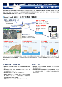
FIGにおけるUAVに関する開発と利用動向
平成27年度日本測量者連盟講演会
3月18日
福島芳和
Commission 5 の活動
FIGのCommission 5 における
今後のUAVに対する位置づけ
(UAV能力の評価、マルチセンサシステム)
Specific project(s)
1 - International field experiments and workshops on a range
of multi sensor systems and technologies.
2 - Evaluation of UAV capabilities and the increasing role of
multi-sensor systems in UAV navigation.
3 - Investigate the role of vision based measurements in
improving the navigation performance of multi sensor
systems.
4 - Development of shared resources to encourage rapid
research and advancements internationally.
UAVの発表セッション
2015TS04H - Kinematic Data Aquisition and Processing Techniques
A Direct Georeferencing System for the Real-Time Position and Attitude Determination of Lightweight UAVS
TS05B - Remote Sensing and UAV in Land Administration
UAV Use in Italy by Surveyors
Developing a Highly Effective and Efficient Land Administration System Through the Application of UAV
TS06E - Joint Commission 5 and 6 Session on UAV and Photogrammetry
Accuracy Assessment of Bundle Adjustment with UAV Based on Images of Tropical Forest Using Sparse Control
2014TS05B - Laser Scanning Techniques and Applications 2
Documentation of Remote Archaeological Sites - a Comparison Between Long Range Laser Scanning and Uav-Based
Photogrammetry
TS10E - Engineering Surveying with Unmanned Aerial Vehicles (UAV) and Remote Sensing
UAV System With Terrestrial Georefferencing For Small Area Mapping
TS11B - Developments with Unmanned Aerial Vehicles (UAV)
Assessment Quality of an Uav-Based Orthomosaic and Surface Model of a Breakwater
Introducing a New Class of Survey-Grade Laser Scanning with Unmanned Aerial Systems
Determination Surface Characteristics and Alteration of Koru Mining Area(NW Turkey)by UAV Photogrammetry
UAV Based Monitoring of Adatepe Landslide, Canakkale, NW Turkey
Applicablity of Rotary UAV(Unmanned Aerial Vehicle) for Vegetable Crop Investigation
Mapping the Outermost Small Islands Utilizing Uav-Based Aerial Photography
TS11E - Engineering Surveying
Application of low-altitude UAV aerial photography system in 1:2000 orthophoto map production
調査目的
○使われているUAVは?
○利用目的毎の違い
○発表者の関心領域
○運用の問題
さらなる観点
○利用は日本と似ている?
○特徴的な技術は?
○参考になる各国メンバーの活動は?
材料
○FIGにおける、発表資料
○Member associationの活動(HP)
UAVの利用国(撮影場所を大陸別に)
アジア
9
ヨーロッパ
12
北米
0
中南米
(遺跡)
1
オセアニア
0
アフリカ
0
ヨーロッパとアジア
で関心あり
○UAVの機体の種類(実際に使用した)
マルチコプターが最大
固定翼もそれなりに
マルチコプターの羽の数
羽の数は増えてい
るかと思ったが…
○UAVの利用目的
多分野で利用。
DEM,DSMが1番。
地籍が多い。
固定翼の利用目的(計6事例)
使う分野が限定
DEM,DSMが一番。
○マルチコプターUAVの機種
Microdrone MD4-1000
MikroKopter OktoXL customized
esacopter(DJI)
LX-UAV1(SIRI, Korea)自国開発
Tarot 680 Ironman
Trimble UX5 Aerial Imaging Rover
SenseFly UAV, eBee
SenseFly Swinglet CAM
octocopter SKY II
ルーマニア大学からスピンオフした航空メーカ
自作のEight-Rotor Oktokopter, IMUで安定
Falcon 8
TSH GAUI 540H
3
2
1
1
1
1
1
1
1
1
1
1
1
選択根拠を
書いた論文
は無い。
機種名を書
いていない
論文も3つあ
り。
たぶん、こだ
わりなし。
開発もある。
デジタルカメラの機種
*Sony Nex 5R
*Sony Nex-5R digital camera
*Sony Nex-5R digital camera
*Sony Nex-7
*Sony NEX 5, キャリブレーション実施
*Canon EOS 550D calibrated camera
*Canon PowerShot SD 780
*Canon IXUS 220 HS (3000×4000 pixels)
*Panasonic DZC- 10, Fuji SX200, and Nikon 3100D,
vibration cushioning, gyros-stabilization
*Olympus E-P3 OGT camera、キャリブレーション実施
*Tetracam ADC(赤と近赤外)
*Reflex photogrammetric cameras,キャリブレーション実施
日本の
メーカー
が多い。
目的毎の地上分解能(1)
分解能
論文数
目的
約1cm
2
地籍
コンクリートダムの水の漏出
約2cm
4
地震による屋根の劣化
地震後のDSMと画像作成
突堤(岩)
遺跡
約5cm
1
地籍
約10cm
2
離島(国境)の地図作成
目的と地上分解能(2)
分解能
目的
約1cm
地籍(オランダ)
(所有者の立会時には、可
能な限り現実に近い高分解
能画像が必要だから)
コンクリートダムの水の漏出
(ポルトガル)
目的と地上分解能(3)
分解能
目的
約2cm
地震による屋根の劣化
(イタリア)
地震後のDSMと画像
(ネパール)
突堤(岩)
(ポルトガル)
遺跡
(アンデス山脈)
撮影時の運用上の問題点
○風
国境の離島(インドネシア)
突堤(ポルトガル)
旧市街の密集地の歴史的建造物(イタリア)
○通信障害
突堤(ポルトガル)近くの電波塔の干渉?が
原因か、フライト中に通信切れ頻発
ジャミングの研究発表もあり
○精神的リハーサル、電池切れ、着陸後の点
検などの周到な準備が必要
住宅街の地籍(アメリカ研究者がアルバニアで)
課題
○発表の数では、精度検証目的が多い。
地籍のため
DEMやDSMの精度
○森林地域のDEM作成は困難(ドイツ)
○UAVでは、森林下の住宅のDEMは困難で、
MMSと併せてPoint Cloud作成(スイス)
○野菜畑の発育度(韓国)
日本測量協会ではサーベイアカデミー。
FIGメンバー国での会員組織は、UAVについて
何をしている?
○会員ニュースでのUAV紹介
○動画によるUAVの講習(e-CPD会員のみ)(オースト
ラリア 25豪ドル)
○ドローンの規制に関して、航空規制の関係者に陳
情(イタリア)
日本と似ている
参考文献一覧
The Fourth Layer in Collaborative Navigation Going Underground
Highly Detailed 3D Modelling of Mayan Cultural Heritage Using an UAV
Airborne mapping with an Unmannend Aerial Vehicle
Accuracy Assessment of Bundle Adjustment with UAV-based Images of Tropical Forest Using Sparse Control
Rectification Algorithm for Linear Pushbroom Image of UAV
Assessing LARSI-integrated Participation Procedure in Urban Adjudication in China
Development of an Unmanned Aerial Vehicle Platform Using Multisensor Navigation Technology
A direct georeferencing system for real-time position and attitude determination of lightweight UAVs
Autonomous Aerial Sensing – Fast Response and Personalized
Jamming and Spoofing of GNSS Signals – An Underestimated Risk?!
The Use of Terrestrial Laser Scanning for Post-Accident Deformation Evaluation of a Train Wagon
Mapping the Outermost Small Islands Utilizing Uav-Based Aerial Photography
UAV System With Terrestrial Geo-referencing For Small Area Mapping
MICRO UAV FOR POST SEISMIC HAZARDS SURVEYING IN OLD CITY CENTER OF L'AQUILA
Environmental Risk Monitoring by Satellite, LiDAR, Topographic and UAV Photogrammetric Survey Techniques
タイトル不明from confusion to produce topographic
Lessons from East Japan Earthquake and Tsunami
UAV- Based Imaging – Digital Elevation Model Extraction
UAV- Based Imaging for Environmental Sustainabilitty-Flash Floods Control Perspective
https://www.fig.net/resources/proceedings/fig_proceedings/fig2015/papers/ts06e/TS06E_ajibola_masor_et_al_7671.pdf
Generation of High Resolution DSM Using UAV Images
UAV for Post-Disaster Quick Assessment
USE OF EARTH OBSERATION AND ALLIDED TOOLS – OPERATIONAL CHALLENGES, AND LESSON LEARNED FROM NEPAL EARHTQUAKE OF 2015
Full Automatically Generated True Orthophotos, Sensational 3D Pointclouds and Dense Matching Techniques in Topographical Mapping
Preparing Kadaster for the Future and Contribute to Sustainable Economic Development
Developing a Highly Effective and Efficient Land Administration System Through the Application of UAV
Assessing the Quality of an UAV-based Orthomosaic and Surface Model of a Breakwater
ASSESSING THE QUALITY OF AN UAV-BASED ORTHOMOSAIC AND SURFACE MODEL OF A BREAKWATER
https://www.fig.net/resources/proceedings/fig_proceedings/fig2015/papers/ts06e/TS06E_henriques_braz_7605.pdf
Applicability of Rotary UAV for Vegetable Crop Investigation
Location and delimitation of the climatic changing areas: the potential of a UAVs based validation
Terrain Mapping by Applying Unmanned Aerial Vehicle and Lidar System for the Purpose of Designing in Serbia
Modern Acquisition Technology of Spatial Data as a Basis of Environmental Engineering and Planning Projects
Documentation of Remote Archaeological Sites – A Comparison Between Long-Range Laser Scanning and UAV-Photogrammetry
The rayCloud – A Vision Beyond the Point Cloud
Next Generation SMART Cities: The role of Geomatics
Low Cost Aerial Mapping Alternatives for Natural Disasters in the Caribbean
Rapid Processing of Unmanned Aerial Vehicles Imagery for Disaster Management
UAV Based Monitoring of Adatepe Landslide, Canakkale, NW Turkey
Determination Surface Characteristics and Alteration of Koru Mining Area (NW Turkey) by UAV Photogrammetry
Evaluating Quality of UAV´s Products: Study Case Uruguay
Virtual Surveying: Mapping and Modeling Cadastral Boundaries Using Unmanned Aerial Systems (UAS)
Introducing a New Class of Survey-GradeLaser Scanning by use of Unmanned Aerial Systems (UAS)
Automated processing for 3D Mosaic generation,
ありがとうございました。
© Copyright 2026 Paperzz