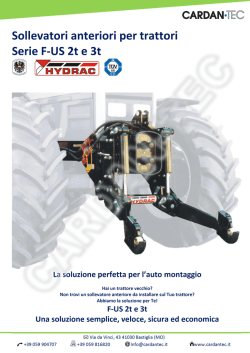
JRA vol. 23 - 2010
JOURNAL OF
ROMAN
ARCHAEOLOGY
EXTRACT
RABUN TAYLOR, KATHERINE RINNE
MICHAEL O’NEILL & EDWARD O’NEILL
A grotto-shrine at the headwaters
of the Aqua Traiana
Ann Arbor, 2010
BLANK PAGE
Table of contents of fascicule 1
Articles
R. Goffredo
Persistence and change in settlement patterns in the
Ofanto valley near Canusium and Cannae (Apulia)
(late 4th c. B.C.-1st c. A.D.)
S. G. Bernard
Pentelic marble in architecture at Rome
and the Republican marble trade
M. Heinzelmann, D. Jordan & C. Murer
Amiternum and the upper Aterno valley:
a Sabine-Roman town and its territory
E. Netzer, Y. Kalman, R. Porath & R. Chachy-Laureys
Preliminary report on Herod’s mausoleum
and theatre with a royal box at Herodium
C. Bruun
Water, oxygen isotopes, and immigration to Ostia-Portus
K. Killgrove
A response to C. Bruun
D. Adan-Bayewitz, K. W. Slane, F. Asaro & R. D. Giauque
Silver in ancient pottery: context matters
W. Van Neer, A. Ervynck & P. Monsieur
Fish bones and amphorae: evidence for the production
and consumption of salted fish products outside the
Mediterranean region
Z. Weiss
From Roman temple to Byzantine church:
a preliminary report on Sepphoris in transition
U. Leibner
Excavations at Khirbet Wadi Hamam (Lower Galilee):
the synagogue and the settlement
U. Leibner & S. Miller Appendix: A figural mosaic in the synagogue at Khirbet
Wadi Hamam
H. Dey & B. Goodman-Tchernov
Tsunamis and the port of Caesarea Maritima over the
longue durée: a geoarchaeological perspective
P. Dilley
Christian icon practice in apocryphal literature:
consecration and the conversion of synagogues into churches
7
35
55
84
109
133
137
161
196
220
265
285
Archaeological notes
G. E. Meyers, L. M. Jackson & J. Galloway
The production and usage of non-decorated Etruscan rooftiles, based on a case study at Poggio Colla
M. Buora & V. Roberto New work on the plan of Aquileia based on
aerial photographs and a GIS platform
D. Nappo
On the location of Leuke Kome
C. Davenport
The building inscription from the fort at Udruh
and Aelius Flavianus, tetrarchic praeses of Palaestina
R. Taylor, K. Rinne, E. O’Neill & M. O’Neill
A grotto-shrine at the headwaters of the Aqua Traiana
U. Quatember
The “Temple of Hadrian” on Curetes Street in Ephesus:
new research into its building history
A. S. Reiterman
Clamp-holes and marble veneers:
the Pantheon’s lost original facing
K. M. D. Dunbabin
The pantomime Theonoe on a mosaic from Zeugma
J. Ma
A note on lead projectiles (glandes, molybdides) in support of
sling bullets: a reply to T. Rihll
303
320
335
349
358
376
395
413
427
358
R. Taylor, K. Rinne, E. O’Neill & M. O’Neill
Fig. 1. Grotto of S. Fiora, general view (R. Taylor).
Fig. 2. Sestertius of Trajan, A.D. 109-117 (© Trustees of the British Museum).
A grotto-shrine
atheadwaters
the headwaters
of Aqua
the Aqua
A grotto-shrine
at the
of the
Traiana
Rabun Taylor, Katherine Rinne, Edward O’Neill, & Michael O’Neill
This article reports, in a preliminary fashion, on a discovery of great significance to
the history and archaeology of the aqueducts of Rome. In spring 2009, after a period of
intensive archival research and communication with public authorities in the districts of
Bracciano and Manziana, two of the present authors (M. and E. O’Neill) gained temporary
access to a defunct spring source on the W rim of the caldera of Lake Bracciano, 45 km
northwest of Rome. The area has long been valued for its abundance of springs delivering premium-quality water for a variety of destinations and uses. Many of them have
been exploited since antiquity, but few preserve visible traces of Roman engineering. The
source in question, buried deep within a thicket of mature fig trees and lost to modern
scholarship,1 is a nearly pristine grotto-shrine of the Roman Imperial period, later adapted
to accommodate a hermitage church named S. Fiora (fig. 1). Not only does the grotto
encompass a capacious springhouse, in well-preserved Roman masonry, but it connects to
several feeder conduits uphill and to c.80 m of an equally well-preserved aqueduct channel
downhill. By all appearances, S. Fiora began its life as the headwaters of the Aqua Traiana.
The Aqua Traiana
The Aqua Traiana was dedicated on 24 June, A.D. 109, two days after the Thermae
Traiani on the Oppian Hill and less than 6 months before the Naumachia Traiani in the Ager
Vaticanus. These two grand waterworks may have offered justification enough for introducing a new aqueduct to Rome, but the Fasti Ostienses add an important detail about the
system serving them: the Traiana was tota urbe salientem, a pan-urban network of streetside
outlets and basins. With so vast an urban distribution network, the new aqueduct probably
rivaled its largest predecessors in volume.2 Trajan celebrated his great project with a series
of coins issued between 109 and his death in 117 (fig. 2).
Since the 17th c., it has been known that the Traiana’s numerous sources originated
in the water-rich volcanic hills west and northwest of Lake Bracciano. Gathering these
waters along the way, the conduit circled clockwise around the lake before turning toward
Rome. Fieldwork and archival research conducted by the O’Neills in 2010 has clarified
many details about this system (fig. 3). As recently as the mid-18th c., A. Cassio was able
to identify three principal sectors from which the Traiana drew its waters, but by the 1870s
R. Lanciani could positively identify none of them. Cassio refers to the headwaters (capi) of
the network as “those that came from the so-called Fosso di Fiora”, a stream running past
the church for which it was clearly named. He said nothing more about these capi, remarking only that they were smarrite (lost),3 by which he presumably meant not that they were
1
2
3
The only modern reports of which we are aware are two brief articles, with photographs, in the
local periodical La voce del lago — one by Architetto G. Curatolo (no. 40, Nov. 2005), the other
by Dott. S. Cecconi (no. 61, May-June 2010); both are available online. We are grateful to Arch.
Curatolo for his assistance in exploring S. Fiora.
Bloch 1944, 339. On the Aqua Traiana within the city, see also Van Buren and Stevens 1915-16;
Bell 1993 and 1994; Evans 1994, 129-33; Taylor 2000, 207-47, and id. 2010; Wilson 2000. On the
Naumachia, see Berlan-Bajard 2006, 178-215; Mazzei 2008; Cariou 2009, 111-61.
Cassio 1757, 1.170: “Le sorgenti in tempo di Trajano scorrevano da tre parti in numero maggiore di quelche sono al presente; perchè i Capi di quelle, che venivano dal Fosso che si diceva
360
R. Taylor, K. Rinne, E. O’Neill & M. O’Neill
Fig. 3. Map of the sources and conduits of the Aqua Traiana in the Lake Bracciano region (© E. O’Neill).
Information drawn from Cassio 1757; from Carta Topografica dell’Istituto Geografico Militare f. 143, tav. III
N.E.; from Archivio di Stato di Roma, Disegni e Mappe, coll. I, cart. 10, n. 113 bis; from Archivio di Stato di
Roma, Collezione Ospedale di S. Spirito (fig. 17 below); and from measurements made in the field.
defunct but that their advantages were lost to Rome, for at that time the waters were serving the town of Bracciano abundantly. From the mid-19th c. until the recent rediscovery
of S. Fiora, the sources went virtually unremarked. Discouraged by Lanciani’s failure to
identify them, archaeologists and aqueduct-hunters were content to focus on the specus,
which comprises a few visible ruins in the field and miscellaneous segments that were
incorporated into the Acqua Paola, the Papal reconstitution in the early 17th c. of the ancient
aqueduct.4 The latter-day aqueduct still delivers a healthy volume of water to Rome, most
famously through the grand fontanone of Paul V on the Janiculum. While still potable, it
4
di Fiora, sono smarrite”. See Nibby 1849, vol. 3, 259; Lanciani 1880, 375.
Fabretti 1680, 49-57; Cassio 1757, vol. 1, 167-74 and 353-63; Fea 1832, 36-57; Nibby 1849, vol. 3,
254-68; Lanciani 1880, 374-80; Van Deman 1934, 331-40; Ashby 1935, 299-305; Virgili and Santolini 1986; Virgili 1993; Evans 2002, 56-62.
A grotto-shrine at the headwaters of the Aqua Traiana
361
is no longer used for drinking, having been supplemented since 1673 by water directly
from Lake Bracciano, which compromised its taste. Very little of its main conduit follows
the ancient aqueduct, but a deed of transfer of 1608 indicates that a number of the Paola’s
sources were ancient, and inscriptions celebrating the aqueduct say the same.5 Because
the Aqua Traiana was not yet in operation at the time of publication of Frontinus’ De aquis
(c.A.D. 97-98), the only ancient reference to it known in the early 16th c. was on the coinage, and no one had yet associated it with the city of Rome. Paul V and his engineers
presumed that the ancient remains they were encountering belonged to the Aqua Alsietina,
an Augustan aqueduct that had almost ceased to function by Trajan’s time.6 Analysis of
subfossilized trees at its point of origin has shown that, at approximately the same time as
Frontinus was complaining about the Alsietina’s poor quality (Aq. 8.13), the water level of
the aqueduct’s principal source — the Lacus Alsietinus, modern Lake Martignano — was
descending due to seismic activity. It would soon leave the original intake high and dry,
necessitating a significant and ultimately unsuccessful adjustment in the engineering.7
The foremost aqueduct authorities of the earlier 20th c., E. Van Deman and T. Ashby,
examined remains of the Traiana’s specus a mere stone’s throw downhill from S. Fiora
along the Fosso.8 For reasons unknown, neither they nor their most prominent predecessors (A. Nibby and Lanciani) set eyes upon the source, though Van Deman refers to the
5
6
7
8
A transcript of the deed is given in Fea 1832, 135-39. The terms used are condotti vecchi, aquedotti
antichi e moderni, etc. Among the named sources not affected by the sale is included a “Fiore”
(138). See also Biblioteca Apostolica Vaticana, Urb. Lat. 1075, 2:457r, 28 July 1607, and 470r-470v,
1 August 1607, for documents related to this and other springs in the area that were considered
for the Acqua Paola.
Bruun 2001; Taylor 2000, 169-200. Even before Pope Paul, some antiquarians understood that
an aqueduct from the Bracciano region had served Rome; the Pianta di Roma antica (1579) by
M. Cartaro, which is crammed with fictive “ancient” features known only by inference, includes
an aqueduct arcade high on the Janiculum labeled “Aqua Sabatina” (Lacus Sabatinus being the
ancient name for Lake Bracciano; see Frutaz 1962, tav. 55). The name is a borrowing from the
Liber pontificalis, which documents the early mediaeval reclamation of the Traiana by Hadrian I
(A.D. 772-795) and Gregory IV (A.D. 827-844; Lib. Pont. 97.59 and 103.19 = Duchesne 2.503-4 and
2.77). Paul V was aware of the Liber pontificalis references, as confirmed in an inscription along
the course of the Paola at S. Maria di Galera: Paulus V Pont[ifex] Max[imus] formis aquae Alsietinae
olim ab Aug[usto] Caes[are] extructis mox collapsis ab Hadriano I Pont[ifex] Max[imus] instauratis
iisdem rursus vetustate dirutis opere subterraneo et arcuato restitutis aquam ex agro Bracciani ditionis
Ursinorum [=Orsini] salubrioribus fontibus derivatam in urbem perduxit an[no] sal[vatoris] MDCVIII
pont[ificato] IV.
Moccheggiani Carpano 1976; Liberati Silverio 1986; Cordiano 2007. The flow of the Alsietina
did not cease altogether. Under Augustus it acquired a supplementary source, the forma Mentis
(CIL VI 31566), and its water still served an auxiliary function when Frontinus wrote (Aq. 8.13).
Mazzei (2008) argues that Trajan restored the aqueduct and naumachia of Augustus, and relied
on the Aqua Alsietina, not the Traiana, to power the water mills along the conduit running
beneath the American Academy. Her interpretation of a fragmentary Trajanic inscription referring back to some public act of Augustus late in his career is ingenious. At the critical phrase
restitue]rit st[agnum, however, many verbs could be substituted, as could the nouns statuas,
structuram, stipes, stipendia, or indeed a gerundive of struo, statuo, vel sim., with some unknown
object referent. The Alsietina’s main source was a small volcanic lake that probably could not
have provided continuous, year-round service to power the water mills on the Janiculum; see
Taylor 2000, 176-77. The construction trench of the channel excavated at the American Academy
revealed pottery of the 1st and early 2nd c. A.D. (Wilson 2000, 221). With the new discovery,
chemical tests of the mineral deposits on each sector could resolve the matter decisively.
Van Deman 1934, 333; Ashby 1935, 300-1.
362
R. Taylor, K. Rinne, E. O’Neill & M. O’Neill
church. This is especially surprising given the fact that the identity of the source, and a
brief description, are provided in the Storia delle acque di Roma (1832) by C. Fea, who was
better informed than Cassio:
According to a report on this spring [i.e., S. Fiora] from 25 February 1667 by the architect
Luigi Bernini on the orders of Alexander VII, it is perhaps the foremost of all the ancient
Traiana waters. Although it was excluded from the total sale, he wanted it … for his second
fountain in Piazza S. Pietro; still, he had no objection to the water of Lake Bracciano. It rises
under the church called La Madonna della Fiora in the territory of Manziana, virtually at
the head of the entire ancient conduit. If Bernini’s calculations were correct, at that time it
issued about 340 oncie of water of the highest quality and lightness [i.e., low specific gravity]. In front of the church there exist remains of connections [allacciatura], vaulted tanks
[botti], and sections of the conduit — both higher up and lower down, where it issues forth
to turn grain mills. Bernini had found another water source for the mills, and he said that,
apart from the need for the aforementioned fountain, [the water] could be sold for a profit
of 18,000 or 20,000 scudi after expenses were paid. But the Pope died in the same year, and
everything was suspended; then the lake water was substituted in 1673.9
We were startled to find not only that the exact site of S. Fiora is represented on many
maps dating from the 17th c. down to the present (in recent centuries, mainly as a simple
toponym without any additional identifier), but that its waters were still serving the town
of Manziana until the 1980s, when two adjacent wells were drilled to supply the entire
town of Bracciano, significantly lowering the water table.10 Not even Fea, it seems, thought
to look inside the church itself. Perhaps, as so often is the case in water-rich districts, a
local code of secrecy deflected even the most persistent external inquiries about water
sources; but Ashby’s oddly perfunctory tone, echoed by Van Deman, suggests that both
misinterpreted Cassio’s descriptor of S. Fiora’s waters as “lost” to mean “defunct”. They
seem to have been unaware of Fea’s report.
However, a few local authorities have known of this site for many years, and we owe
them (and particularly S. Cecconi) a debt of gratitude for bringing it to our attention. Today
S. Fiora is dry and useless, and it is suffering from its new-found obsolescence in a most
alarming way: having lost its accustomed contents of water, and thus the static equilibrium
for which the springhouse was designed, the lower courses of masonry are falling inward;
all the while, fig roots are gradually prying its walls and vaults apart.
The grotto site and its galleries
S. Fiora lies c.2.5 km north-northeast of Manziana on a gentle slope of SE exposure
between Lake Bracciano and the ancient Via Clodia. It lies c.150 m due west of a known
spring bearing the toponym Fonte del Gatto, and c.200 m east of the Rome railway line. Its
elevation is c.320 m above sea level, a full 245 m above the summit of the Janiculum where
the Aqua Traiana entered the city. A creek (Fosso della Fiora) runs southeast from the site
toward Località Vigna Grande, the home of water-powered grain and oil mills by at least
the 16th c., and then to Lake Bracciano (fig. 4).11 Augmented by the aqueduct, this creek
9
10
11
Fea 1832, 41 n.6 (transl. R. Taylor). On the early history of the Acqua Paola, see now Rinne 2010,
chapt. 6.
G. Curatolo, pers. comm.; he also kindly provided other details about the source and its recent
history.
Fea (1832, 138) mentions that the grain mills were powered from three sources: Fiore (Fiora?),
Matrice, and Carestia.
A grotto-shrine at the headwaters of the Aqua Traiana
363
Fig. 4. Detail of a map of 1716 of the Vicarello region (courtesy Orsini Archives, Univ. of California at Los
Angeles). S. Fiora is feature M; Vigna Grande is H. The mills are labeled L and I. The grain mill was on the
Bracciano (W) side of the stream, the oil mill on the Vicarello (E) side.
long served as the boundary between the territories of Vicarello on the east and Manziana
and Bracciano on the west.
The site of S. Fiora remains in private hands and cannot be properly surveyed. However, in the spring and summer of 2009 we were able to explore and photograph the grotto
chambers and the Aqua Traiana’s specus as far as a junction chamber some 80 m downstream.
Completely out of view in a dense thicket of fig trees, the picturesque grotto complex is
astonishingly well preserved. It comprises three adjacent chambers excavated into the hillside and originally communicating through expansive lateral archways. The complex is
made almost entirely of Imperial-era opus latericium vaulted with opus caementicium, upon
364
R. Taylor, K. Rinne, E. O’Neill & M. O’Neill
Fig. 5. Interior of the central chamber (K. Rinne).
Fig. 6. Left chamber (R. Taylor).
A grotto-shrine at the headwaters of the Aqua Traiana
365
which can still be seen traces of plaster bearing Egyptian blue fresco.12 The three chambers
form a suite, but their plan as a whole is neither symmetrical nor rectilinear. The continuous back wall follows a pronounced curve which on the left side of the main entrance
meets the front wall at a sharp angle, creating a triangular left-hand chamber. The main,
central chamber is the most symmetrical, a rectangle in plan. The right chamber forms
roughly a quarter-ellipse, the longest side of which is the oblique curve of the back wall.
The central chamber is entered through a stone archway opening into the hillside (fig.
1). This was the aesthetic focal point of the complex, for it is taller than the side chambers
and preserves a statue niche set axially in the back wall. Only the top of the niche (partially
chiseled away during the Late Mediaeval or Renaissance period to accommodate a shrine)
emerges from the dirt floor (fig. 5). The lateral archways dividing the central chamber
from its neighbors, each rimmed with bipedales, are visible. The dirt floor rises at least 3 m
above the Roman level. It appears to consist of artificial fill, for on the right side it terminates abruptly at a post-Roman retaining wall that blocks the lateral arch leading to the
right chamber. The fill continues into the left chamber, rendering it nothing more than a
crawl space. The upper part of the left lateral arch was hacked away in a crude manner to
facilitate entry (fig. 5). The right lateral arch, as we have seen, was blocked by a retaining
wall for the earthen floor. The wall continues up from the existing floor level to seal off the
entire arch, except for a small wooden door framed with modern cement. A 1920s-era gasoline pump, visible in the foreground, was once attached to a hose that extended through
this door into the right chamber, which may have been cleared of débris at that period, so
that it is now possible to descend to the Roman level.
All three chambers are elegantly vaulted and preserve shafts for natural lighting, though
each has been intentionally blocked. The central chamber is cross-vaulted; a beveled light
embrasure, sealed by modern brickwork, cuts into the wall above the right lateral arch.
Each of the irregularly-shaped side chambers carries a groin vault custom-designed to
fit the plan; and in each case, the vault culminates at the center in an oculus-like light
shaft ringed with bipedales (fig. 6). Above the bricks, the shafts are lined with mortared
fieldstone.
Architecturally and functionally, the right chamber is the most extraordinary, for it
served as the springhouse (fig. 7). Since its floor remains at Roman level, one can take
the full measure of the lateral arch that once gave entry to the central chamber: it rises c.4
m at its crown. Two galleries pierce the curved back wall. Facing into the hill, an arched
opening (visible in fig. 7) leads to a web of galleries running uphill, all of them blocked by
rubble. At the far right, facing downhill, is a similar opening, elegantly rounded on its left
side to smooth the flow of water (fig. 8). Here began the water’s descent to Rome.
The walls of the entire right chamber and of the downhill gallery have one striking
feature. About two Roman feet from the dirt floor, the opus latericium of the walls gives
way to two courses of carefully-dressed, medium-sized blocks of volcanic stone laid in a
traditional stretcher bond, but without clamps or mortar (figs. 7-8). Examining areas where
the facing blocks have fallen away, we determined that an additional pair of courses lies
behind them. Each vertical joint consists of a gap c.1-2 cm wide, allowing water to filter
into the system from behind the wall.
12
In 2009, M. C. Tomassetti performed chemical analysis on the pigment, confirming that it is
Egyptian blue and thus of Roman origin.
Fig. 8 [right]. Entrance
to the gallery extending
downhill from the right
chamber (R. Taylor).
Fig. 7 [left]. Right
chamber (R. Taylor).
366
R. Taylor, K. Rinne, E. O’Neill & M. O’Neill
A grotto-shrine at the headwaters of the Aqua Traiana
For about the first 50 m, the downhill gallery combines conventional
features of a Roman aqueduct specus,
namely a concrete barrel-vault punctuated by vertical service shafts, with
the wall-filtration system and dirt
floor of the springhouse. No part
of this hybrid sector of the aqueduct shows any evidence of being
excavated from living rock; it was
built in the cut-and-cover technique,
excavated down from the surface. Like
the oculus shafts in the grotto chamber, the vertical service shafts have
been blocked, but fig roots infiltrate
them and run long distances down the
gallery, detaching the plaster or opus
signinum linings on the vaults and
walls. Unlike the first service shaft,
which is fairly narrow and circular in
section, the second is the full width
of the gallery and square in plan; its
walls are lined in opus latericium for
at least 2 m above vault level (fig. 9).
Irregular toeholds are visible along its
sides. This may have been a ‘mothershaft’, a point of origin, reference, and
supply, from which early phases of
construction proceeded.
367
Fig. 9. Service shaft in the downstream filtration gallery
(R. Taylor).
At this point the gradient becomes slightly steeper. To slow the descending waters,
the engineers designed an S-curve in the channel’s plan (fig. 10). Some 50 m or less from
the collection chamber the hybrid masonry and dirt floor suddenly give way to the standard technique known from other sectors of the Aqua Traiana, namely opus reticulatum
lined with a thick layer of opus signinum. This point of transition is very well preserved
(figs. 11-12). Even the continuous quarter-round bead of the opus signinum at the junction
of wall and floor is intact. For the length of our explorations down this gallery, as well
as in the collection chamber, it was possible to detect the average water-level during the
aqueduct’s functional life from the pronounced charcoal-colored deposit on the walls. It
appears to be identical to the deposits in the sector of the Aqua Traiana underlying the
American Academy in Rome. Hopefully, samples will be collected for chemical analysis. The rapidly-accumulating calcium carbonate that afflicted other aqueducts of Rome
is conspicuously absent from this source, hence the “lightness” of the water cited by Fea.
Although architecturally-enhanced spring-nymphaea were common throughout the
Roman world (the Fons Egeriae near Rome is a typological cousin to S. Fiora), no similar
monumentalization of an aqueduct’s source is known in Italy.13 Its elaborate architecture,
13
Roman aqueduct nymphaea are attested elsewhere, most famously at the headwaters of the
368
R. Taylor, K. Rinne, E. O’Neill & M. O’Neill
Fig. 10. S-curve in the downstream gallery (E. and M. O’Neill).
Fig. 11. Junction of the downstream filtration gallery and the lined aqueduct specus (E. and M. O’Neill).
the axial statue niche (presumably either of Trajan or a local nymph14), and the evidence
for wall- and vault-decorations indicate that the place was intended for presentation to
14
Carthage aqueduct; the three-chambered springhouse at Aïn Djoukar (Rakob 1969, 1969-70,
and 1974) is a particularly good comparandum to S. Fiora. On others in Africa Proconsularis, see
Rakob 1969-70, 140. For an Egyptian example, see Sidebotham et al. 1994.
At a source of his new aqueduct to Syrian Antioch, Hadrian established a temple to the
nymphs, within which was a seated statue of himself holding the globe of Zeus (Malalas, Chron.
11.363-64).
A grotto-shrine at the headwaters of the Aqua Traiana
369
the public. The open, tripartite design
ensured that visitors could gaze upon
the welling waters in the right-hand
chamber, perhaps tossing in coins for
good luck, just as Trajan’s contemporaries did at the Clitumnus spring in
Umbria (Plin., Ep. 7.8). If Bernini and
Cassio were right, the S. Fiora spring
was the most important of all sources
feeding the Aqua Traiana, earning the
right to symbolize the system’s sources
in toto. One wonders if the central
arched entrance to the grotto is the one
that was represented schematically on
the coinage celebrating the aqueduct
(fig. 2).
The later history of S. Fiora
The name Fiora or S. Fiora, and presumably a church or religious community attached to it, can be traced to this
spot as far back as 1234, when it probably became affiliated with the Ospedale di S. Spirito in Rome.15 This is still
reproduced on maps, although evidently the site’s significance was lost
to memory after the 19th c.16 A church
building erected directly over the grotto Fig. 12. Masonry seam between the opus testaceum filtration gallery and the opus reticulatum specus (R. Taylor).
incorporated the central chamber and
its niche, which seem to have been converted into a devotional shrine. Very little of the
church’s superstructure survives, but blocks of dressed masonry can be seen in the underbrush above the grotto. The church became a hermitage preserving a miraculous portrait
of the Virgin, the “Madonna della Fiora”.17 Well after the property came into the hands
of the Orsini in 1491, maps (chiefly of the 17th-18th c.) began to represent the church in a
formulaic way, with simple gabled roof and small campanile, yet in a few instances water is
shown gushing from beneath the building (as on fig. 4, feature M). On a map of Vicarello
15
16
17
Chiricozzi 1986, 316; Carafa and Curcio 1979, 131. Many records of episcopal visits to S. Fiora
are held at the Archivio Storico Diocesano di Cività Castellana at Nepi. In several cases the
names of the resident hermits are given (e.g., Fondo Vescovi b. 66.1, c. 141r; b. 66.2, c. 162r). The
Ospedale’s reach in this region was extensive. An inscription on the fountain at the church of
S. Spirito in Saxia, dating to 1614 (just after the Acqua Paola was introduced) includes a reference
to sources of the “Aqua Alsietina” (i.e., Traiana) originating at Manziana: Petrus Camporeus Praeceptor ex aqua Alsietina e finibus Mantianae a Paulo V in Vaticanum perducta fontem aperuit an(no)
D(omi)ni MDCXIIII.
The church was dissolved in 1889; see Carafa and Curcio 1979, 131.
Archivio Storico Diocesano di Cività Castellana, Fondo Vescovi, b. 41, fasc. 1, c. 41v (year 1670).
It records damage done to the “effigies miraculosa B[eate] Marie” by humidity.
370
R. Taylor, K. Rinne, E. O’Neill & M. O’Neill
of 1687 (fig. 13) this feature is described
as “Church of the Madonna della Fiora,
beneath which emerges the water that
enters the Fosso”. The unusual collection of
features thus comprised a grotto hermitage
church; a miracle-working Virgin, probably portrayed within the Orsini-era stucco
frame directly above the statue niche
(figs. 1 and 5); and an abundant source of
water. One cannot presume any cultural
continuity with Roman antiquity, but the
mediaeval and modern parallels to ancient
source and healing cults are noteworthy.
In Virginio Orsini’s 1608 deed of transfer to Paul V, transcribed in full by Fea,
Fig. 13. Detail of map of the Vicarello region in 1687 the spring of S. Fiora was prominently
(courtesy Orsini Archives, Univ. of California at Los excluded from the transaction. Its volume
Angeles).
exceeded all the others combined, making
it far too valuable to ignore;18 but it was already in use, and its sale was non-negotiable.
In 1573 Paolo Giordano Orsini had conducted the Fiora’s waters to Bracciano’s territory
in a new conduit,19 which ran from S. Fiora along the Fosso della Fiora to Vigna Grande.
There it powered several valuable mills (fig. 4).20 Along the Fossa the new channel roughly
paralleled the ruined Traiana; Ashby found relics of the latter’s broken specus there, not far
from the source.21
The Orsini aqueduct actually began at Fonte del Gatto, but it also took water from the
grotto of S. Fiora by the following means. Some 65 m east of S. Fiora, it intercepted the
well-preserved upper specus of the Traiana running from the grotto. A series of sluice-gates
was installed at the junction. A stairwell was built down to the junction chamber and a
small masonry hut provided entry (figs. 14-15).22 This upper sector of the Traiana remained
unknown to all but a few local residents and the regional water authorities until we arrived
in 2009. The junction not only was a confluence of the two waters, but also functioned as
a release valve in the event of excessive flow. Sluice-gates could divert overflow into the
broken downstream sector of the Traiana’s specus, which drained harmlessly into the Fosso
18
19
20
21
22
Fea 1832, 41: “… nell’ istromento di compra se ne escludono molte vene; fra le quali quella detta
della Madonna della Fiora; di presso le 340 oncie, e tutte insieme forse ne formavano altrettanto
volume della comprata: tanto era copiosa la riunione”.
Bibliotheca Apostolica Vaticana, Urb. lat. 1075, 2:457r, 28 July 1607, and 470r-470v, 1 August
1607; see Fea 1832, 139, for the sale of the springs. By the 17th c., the aqueduct powered mills for
grain, paper, and wool tapestry thread, as well as the hammers of an iron foundry.
The deed of transfer says: “Che l’acque del rio delle cisterne, l’acqua che serve alle mole di Bracciano, alla vigna grande, che sono Fiore [=Fiora?], Matrice, e Carestia … debbano tutte restare
intieramente libere al signor Don Virginio [Orsini]” (Fea 1832, 138).
Van Deman 1934, 333; Ashby 1935, 300-1.
For at least several meters upstream from the junction, the opus signinum has been systematically stripped from the walls of the Aqua Traiana’s channel to accommodate a transverse iron
plate and pipe of unknown function. This has revealed the reticulate masonry. Each block of the
facing was scored to receive hydraulic cement.
A grotto-shrine at the headwaters of the Aqua Traiana
371
Fig. 14. Masonry hut above the chamber joining the Aqua Traiana to the old Bracciano aqueduct from the
Fonte del Gatto (E. and M. O’Neill).
della Fiora. Not far downstream,
both Ashby and Van Deman reported
the presence of a deep pool that had
eroded away parts of the specus.23 This
they took to consist of surface water
flowing down the Fosso, but more
probably the conjoined aqueducts
themselves created the pool from their
overflow. At the junction hut, a resident waterman continued to operate
the gates until 1984, at which time new
wells for Bracciano were drilled alongside S. Fiora. Some of the wooden gates
controlling the Traiana conduit remain
in place, the gaps between them filled
with sediment (fig. 16). Our fieldwork
suggests that the Aqua Traiana conduit
crossed the Fosso and paralleled it on
its E side; we hope to investigate this
area further in future seasons.
A plat map dated to 1718 not only
presents the church and its surrounding properties in unusual detail,
but also provides many clues about
23
Van Deman 1934, 333; Ashby 1935, 300.
Fig. 15. Junction of the Bracciano aqueduct and the Aqua
Traiana below the hut (E. and M. O’Neill).
R. Taylor, K. Rinne, E. O’Neill & M. O’Neill
372
Fig. 16. Sluice-gate system at the junction (E. and M. O’Neill).
the nature of the property at that time (figs. 17-18).24 The church (labelled “chiesa et
eremitorio”) is shown at the center as a gabled structure with a campanile. Directly in front
of the entrance, a narrow piazza extends down to a road. At its center stands a monument
bearing the cross of the Ospedale di S. Spirito. Feature G, identified as a chiusino directly
alongside the road, is unmistakeably the junction hut. Feature F, labelled “pozzo d’acqua
corrente” and lying directly between the source and the hut, can probably be identified as
the ‘mother-shaft’ of the Traiana conduit, only a short distance from the source. A nearby
tree appears to function as the pivot for a shaduf, a water-lifting device with a weighted
boom. This well was probably the principal water source for resident monks, field laborers and visiting pilgrims. If by this time the bulk of S. Fiora’s water was destined for grain
mills at Vigna Grande, then the local privilege of hauling up water from the conduit by
hand bears a striking resemblance to the legal rights of landholders who lived along the
course of Rome’s ancient aqueducts.25
Greater S. Fiora
We are confident that other sources of the Aqua Traiana remain to be discovered. Figure
4, a map of 1716 to which we have already drawn attention, may indicate a sector of Roman
conduit that ran between S. Fiora and another source yet to be identified. That sector is
feature Q: “condotto, che pigliava l’acqua spersa detta la Carestia, e la conduceva alla
24
25
Archivio di Stato di Roma, Ospedale di S. Spirito, b. 974, f. 155.
Taylor 2000, 53-76, especially 70-76.
A grotto-shrine at the headwaters of the Aqua Traiana
373
Fig. 17. Plat map of S. Fiora by D. Giammerile from 1718 (courtesy Archivio di Stato di Roma, Collezione
Ospedale di S. Spirito).
Fig. 18. Detail of fig. 17.
R. Taylor, K. Rinne, E. O’Neill & M. O’Neill
374
Fiora”. The name Carestia is unknown in the region today, but Fea mentions it as one of
the sources powering mills at Vigna Grande26 and it may have to do with a second source
nearby, which by the 18th c. was dry (spersa). In any event, Cassio was right in identifying
a cluster of springs at S. Fiora. More grotto-springhouses are probably lurking in the dense
woodland nearby.
The landowner of the S. Fiora site reports that additional chambers exist near the
grotto and that a “labyrinth” of chambers, ducts and pozzi underlies the waterman’s
house adjoining the hut.27 Was this, rather than Vigna Grande, the site of the mills that Fea
saw? Many questions remain to be sorted out; but at present S. Fiora and its premises are
unavailable for further investigation. Their welfare hangs in the balance while the comune
of Manziana struggles to hasten the sluggish process of legal encumbrance that would
restrict private tampering with the site and allow archaeologists and conservators access to
it. S. Fiora’s obvious historical importance justifies full study and conservation, but in the
current political and economic climate nothing is a certainty. Meanwhile, we will develop
plans for a program of structural assessment, conservation, archaeological investigation
and archival research. Long a source of life for many, S. Fiora cannot now be left to die.
[email protected]
Dept. of Classics, University of Texas at Austin
[email protected] Dept. of Architecture, California College of the Arts, San Francisco
ted@/[email protected]
Via Cerveteri 1, 00066 Manziana (RM)
Acknowledgements
We express our deepest gratitude to Lucia Dutto and Giuliano Sala, Mayors of Manziana and
Bracciano, respectively, for their assistance in acknowledging the cultural importance of S. Fiora
since its rediscovery; to Prof. Lorenzo Quilici for his unstinting advocacy for and engagement with
the site; to Dott.ssa Maria Cristina Misiti and Prof. Adriano La Regina for access to essential documents in the Lanciani Archives at the Biblioteca di Archeologia e Storia dell’Arte in Rome; and to
Dott. Settimio Cecconi, Consigliere del Parco Naturale Regionale di Bracciano-Martignano, whose
knowledge of the hydraulic landscape in this region of Lazio is unmatched. He first informed us of
S. Fiora’s hydraulic features, and Varo Augusto Vecchiarelli made available to us the collected papers
for field research around the entire Manziana area conducted by this father Livio over many years.
We owe special thanks to the staff of the Archivio Storico Diocesano di Cività Castellana at Nepi,
especially Francesca Zampaletta, who provided skillful assistance in reading the diocesan records
of pastoral visits to S. Fiora, and Giovanni Isidori (Responsabile Servizio Idrico della Comune di
Manziana), who provided valuable knowledge about, and access to, local waterworks. Two anonymous readers provided helpful commentary on the text of this article.
Bibliography
Ashby, T. 1935. The aqueducts of ancient Rome (ed. I. A. Richmond; Oxford).
Bell, M. 1993. “Mulini ad acqua sul Gianicolo,” ArchLaz 11, 65-72.
Bell, M. 1994. “An imperial flour mill on the Janiculum,” in L’Italie méridionale et le ravitaillement en blé
de Rome et des centres urbains des débuts de la République jusqu’au Haut Empire (CollEFR 196) 73-89.
Berlan-Bajard, A. 2006. Les spectacles aquatiques romains (CollEFR 360).
Bloch, H. 1944. “Aqua Traiana,” AJA 48, 337-41.
Bruun, C. 2001. “Frontinus, Pope Paul V and the Aqua Alsietina/Traiana confusion,” PBSR 69,
299-315.
26
27
See above n.20.
This claim is consonant with the hydrology of the region, with its clusters of discrete sources,
and with Cassio’s use of the plural when referring to S. Fiora as the “capi” of the Trajanic
system.
A grotto-shrine at the headwaters of the Aqua Traiana
375
Carafa, G. and V. Curcio 1979. Manziana: evoluzione storico-sociale del “Tenimentum Castri Sanctae
Pupae” (Rome).
Cassio, A. 1757. Corso dell’acque antiche portate sopra XIV aquidotti (Rome).
Cattani, R. 2000. “Un frammento inedito di CIL XI 3309 dalla Biblioteca del Pontificio Ateneo Antoniano,” Epigraphica 62, 249-60.
Cattani, R. 2002. “Memorie dell’Aqua Traiana: una rilettura di CIL VI 1260,” BollMon 22, 81-97.
Chiricozzi, P. 1990. Le chiese delle diocesi di Sutri e Nepi nella Tuscia meridionale (Grotte di Castro).
Ciancio Rossetto, P. 2006. “Via Aurelia, Acquedotto Traiano Paolo. Nuove acquisizioni scientifiche
(Municipio XVIII),” BullCom 107, 216-28.
Cordiano, G. 2007. “Le oscillazioni delle acque dei Sabatia stagna in epoca giulio-claudia (quadro
d’insieme)”; and “Atlante dei siti: UT 78,” in S. Accardo et al., Sabatia stagna: insediamenti perilacustri ad Anguillara e dintorni in età romana (Pisa) 83-89 and 184-86.
Evans, H. B. 1994. Water distribution in ancient Rome: the evidence of Frontinus (Ann Arbor, MI).
Evans, H. B. 2002. Aqueduct hunting in the seventeenth century: Raffaello Fabretti’s De aquis et aquaeductibus veteris Romae (Ann Arbor, MI).
Fabretti, R. 1680. De aquis et aquaeductibus veteris Romae dissertationes tres (Rome).
Fea, C. 1832. Storia delle acque di Roma e dei condotti antico-moderni delle acque Vergine, Felice e Paola e loro
autori (Rome).
Frutaz, A. P. 1962. Le piante di Roma (Rome).
Hodges, R. 1995. “The archaeology of the Vicarello Estate, Lake Bracciano,” PBSR 63, 245-49.
Kenrick, P. M. 1989. “A section through the ancient Via Cassia, north of Rome, at km. 13.8,” PBSR
57, 77-89.
Lanciani, R. 1880. Topografia di Roma antica: I commentarii di Frontino intorno le acque e gli acquedotti = Le
acque e gli acquedotti di Roma antica (Rome 1975).
Liberati Silverio, A. M. 1986. “Aqua Alsietina,” in Trionfo dell’acqua, 71-79.
Mazzei, P. 2008. “Una nuova epigrafe da San Cosimato in Mica Aurea. Traiano restaura la Naumachia
di Augusto?” RömMitt 113, 147-73.
Moccheggiani Carpano, C. 1976. “Osservazioni sui mutamenti di livello delle acque del lago di Martignano (Roma),” Prospezioni 1, 25-31.
Nibby, A. 1849. Analisi storico-topografico-antiquaria della carta de’ dintorni di Roma (Rome).
Rakob, F. 1969. “Das römische Quellheiligtum bei Zaghouan in Tunisien,” AA 3, 284-300.
Rakob, F. 1969-70. “Le sanctuaire des eaux à Zaghouan,” Africa 3-4, 133-41.
Rakob, F. 1974. “Das Quellheiligtum in Zaghouan und die römische Wasserleitung nach Karthago,”
RömMitt 81, 41-89.
Rinne, K. 2010. The waters of Rome: aqueducts, fountains, and the birth of the Baroque city (New Haven, CT).
Santolini Giordani, R., M. Brucchietti and E. Olmeda 2006. “Via Trionfale. Ritrovamenti archeologici
in via della Pineta Sacchetti (Municipio XIX),” BullCom 107, 284-301.
Sidebotham, S. E., G. T. Mikhail, J. A. Harrell and R. S. Bagnall 1994. “A water temple at Bir Abu Sava
(Eastern Desert),” JARCE 41, 149-59.
Taylor, R. 2000. Public needs and private pleasures: water distribution, the Tiber river, and the urban
development of ancient Rome (Rome).
Taylor, R. 2010. “Bread and water: Septimius Severus and the rise of the curator aquarum et Miniciae,”
MAAR 55, forthcoming.
Il trionfo dell’acqua: acque e acquedotti a Roma, IV sec. a.C.–XX sec. (Rome).
Van Buren, A. W. and G. P. Stevens 1915-16. “The Aqua Traiana and the mills on the Janiculum,”
MAAR 6, 137-46.
Van Deman, E. B. 1934. The building of the Roman aqueducts (Washington, D.C.).
Virgili, P. 1993. “Aqua Traiana,” LTUR vol. 1, 70-72.
Virgili, P. and R. Santolini 1986. “Aqua Traiana,” in Trionfo dell’acqua, 113-19.
Wilson, A. 2000. “The water-mills on the Janiculum,” MAAR 45, 219-46.
Wilson, A. 2002. “Machines, power and the ancient economy,” JRS 92, 1-32.
For more information about this discovery with plans and photos see:
http://www.aqueducthunter.com/fiora
And for the latest news see our new paper: "L'acquedotto di Traiano tra il
Ninfeo di S. Fiora e il Lago di Bracciano" in Atlante Tematico di Topografia Antica
24, 2014, edited by Lorenzo Quilici and Stefania Quilici Gigli and published by
«L'Erma» di Bretschneider.
© Copyright 2026 Paperzz