TECTONICS, VOL. 12, NO. 5, PAGES1267-1279,OCTOBER1993
INTERPRETATION
OF MAGNETIC
ANOMALIES
OVER THE GRENADA
BASIN
DaleE. Bird,1 StuartA. Hall,andJohnF. Casey
Department
of Geosciences,
Universityof Houston,Houston,
Texas
Patrick S. Millegan
MarathonOil Company,Houston,Texas
Abstract. The GrenadaBasin is a back arc basin located near
the easternborderof the CaribbeanPlate. The basinis bounded
more variabilitythan "normal" oceaniccrust[Ludwig et al.,
1971]. Although the crustsof back arc basinsmay not be
identical to that of larger oceanic basins, they do show
systematic,
layeredvelocitystructures.
The plate boundarybetweenthe Caribbeanplate and the
North and SouthAmericanplatesis a subructionzone that is
oriented in a generally north-southdirection (Figure 1).
Similarly,the trendsof the AvesRidge,GrenadaBasinand
LesserAntilles region are orientednorth-south. East-west
extensionis suggested
by thesetrends[Tomblin, 1975].
However,magnetic
dataindicate
thattheactualopening
of the
GrenadaBasinmayhavebeenmorecomplicated
[Birdet al.,
1991].Magneticanomalypatterns
overmanyof theworld's
back arc basinsare poorly organizedindicatingchanging
patterns
of seafloor
spreading;
however,
thepatterns
overother
backarcbasinsare well definedindicatingpreferreddirections
on the west by the north-southtrendingAves Ridge (a
remnantisland arc) and on the east by the active Lesser
Antillesislandarc. Althoughthisphysiography
suggests
that
east-west
extensionformedthebasin,magneticanomaliesover
the basinexhibit predominantly
east-westtrends. If the
observed
magnetic
anomalies
overthebasinareproduced
by
of seafloorspreading.A reviewof backarcbasinslocated
alongthewestPacificmargindemonstrates
thisrelationship
[Weissel,1981]. The orientationof linear anomaliesover
backarc basinsis generallysubparallelto their associated
seafloorspreading,then the orientationof extensionis
complex.Extension
in backarcbasins
is roughlynormalto
the trench,althoughsomebasinsexhibitobliqueextension.
particularly
overthenorthern
partof thebasin(Figure2).
subructionzones. Magnetic anomaliesover the Grenada
Basin, however, exhibit predominantlyeast-westtrends,
Theories
onthedevelopment
of theGrenadaBasingenerally
Presentmodels for the formation of the Grenada Basin vary
agreethatit wasformed
in earlyCenozoic
time.Thedirection
from north-southextension through northeast-southwest
extension to east-west extension. An interpretation of
the GrenadaBasin variesfrom north-south[Pindelland Barrett,
magnetic
anomalies
overtheGrenadaBasinsupports
basin
development
by nearlyeast-west
extension.Low amplitude
magnetic
anomaly
trendssubparallel
to theislandarcmagnetic
anomalytrendsoverthe southern
partof thebasinandthe
resultsof forwardthree-dimensional
(3-D) magneticmodeling
are consistentwith this conclusion. Late Cenozoic tectonic
movementsmay have beenresponsiblefor disruptingthe
magnetic
signature
overthenorthern
partof thebasin.Onthe
basisof our3-D analysis,
we attributetheprominent
east-west
trendinganomalies
of the GrenadaBasinto fracturezones
formedduringseafloorspreading
at low latitude.Thiseastwest trend is not interpretedas indicating north-south
of extensionshownin existingmodelsfor the formationof
1990] to northeast-southwest
[Bouysse,1988] to east-west
[Tomblin,1975]. Apparentcontradictions
in interpretations
of thegeophysical
andgeologic
datahavecontributed
to this
variation in scenarios for the evolution of the basin. The
issue to be addressedhere is the relationshipbetween the
magneticanomalydata and the formationof the basin.
Interpretations
of magnetic
dataoverthebasinhavebeenbased
onqualitative
descriptions
of theanomalies
[Bouysse,
1984,
1988;SpeedandWestbrook,
1984;PindellandBarrett,1990;
Rossand Scotese,1988]. Here a morerigorousanalysisof
themagnetic
datais attempted.
extension of the basin.
TECTONIC AND GEOLOGIC SETTING
INTRODUCTION
Tectonics
Theformationandsubsequent
emplacement
of theCaribbean
plateintotheAtlantichasresulted
in a tectonically
complex
area. Ocean basins in the Caribbean plate include the
Columbian,Grenada,Venezuelan,and Yucatanbasins. The
ColumbianandVenezuelanbasinsare essentiallyscaleddown
versions
of majoroceanbasinsseparated
by theaseismic
Beata
Ridge[Burkeet al., 1984;Caseet al., 1984;Donnelly,1975;
Ghoshet al., 1984; Pindell et al., 1988; Pindell and Dewey,
1982]. The Grenadaand Yucatanbasinsare back arc basins
thoughtto haveformedcontemporaneously
in earlyTertiary
time [Bouysse,1988, Hall and Yeung, 1980- Pindell and
Dewey,1982;RossandScotese,
1988].Refraction
dataforthe
GrenadaBasinand for manyback arc basinsof the Western
Pacificsuggest
thattheircrustsareoceanic[Boyntonet al.,
1979;Edgar,1•OO,
,•,o. Ewinget al., l•J I,
Officer et al., 1957; Officer et al., 1959; Westbrook,1975].
However,the velocitystructures
of back arc basinsexhibit
1NowatWorldGeoscience,
Incorporated,
Houston,
Texas.
Copyright
1993by theAmerican
Geophysical
Union,
Papernumber93TC01185.
0278-7407/93/93TC-01185510.00
Theplateboundary
along
theeastern
edge
oftheCaribbean
plate
isasubduction
zone
withtheCaribbean
plate
overriding
thewestward
dipping
NorthandSouth
American
plates.The
relative motionbetweenthe platesis 2 cm/yr east-west
convergence
[DeMets
etal.,1985].Theabsolute
motion
of
theCaribbean
platein thehotspotreference
frameis 1.5
cm/yrto theeastfortheCaribbean
plate[Jarrard,
1986].
Jarrard
[1986]hasclassified
thissubduction
zone,in terms
of
strainexhibited
in theoverriding
plate,asexhibiting
littleor
nocompression
or extension.
End-members
of Jarrard's
[1986]
strain
classification
scheme
following
earlier
works
are
severe
folding
andthrusting,
asseenalongChile,andactive
backarcspreading,
asseen
intheMariana
Trough.
Thenorth
and southplateboundaries
of the Caribbean
plateare
represented
bybroad
regions
characterized
by strike-slip
motionandlocalizedextension
andshortening.
Depths
ofearthquakes
range
fromlessthan5 kmtogreater
than 150 km in the region,and earthquake
activityis
summarized
by Speedet al. [1984]. Theyreportthatthe
Benioffzonedipssteeply
in thesouthandshallows
to the
northwith the northernandcentralpartsbeingmostactive.
Using
ISCPPandpPdelay
times,
vanderHilstandEngdahl
[1991]
produced
tomographic
images
oftheregion.Theuse
ofthese
twoindependent
datasetsimproved
theresolution
of
theBenioff
zonebeneath
theCaribbean
plate[vanderHilstand
1268
Birdetal.: Magnetics
OvertheGrenada
Basin
20'N
0
100
200
300
km
North
American
Plate
12'N
4 •
10'N
66'W
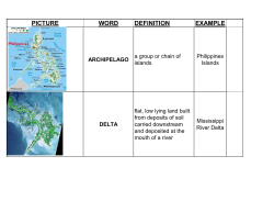
Fig.1.Physiography
of theeastern
Caribbean
with2-, 4-, and5-kinisobaths
contoured
[afterBouysse,
1984]. Theoutlineof thestudyarea,traceof thesubduction
zone,andstrike-slip
faultzoneswhich
definetheNorthAmerican/Caribbean
andSouthAmerican/Caribbean
plateboundaries
aredisplayed.
Heavy dashedlines indicateprobablelocationsfor plateboundaries.The innerand outerarcsare
represented
by dashedanddottedlines,respectively.SB1 and SB2 arecommercial
wellson the Saba
Bank,andH 148andH30 areDeepSeaDrillingProjectsites.
Engdahl,1991]. From a derailedstudyof earthquake
data,
Wadge and Shepard[1984] have mappeda "kink" in the
Benioff zone along the LesserAntilles near 14.5øN. The
TomniandSpeed
[1989]havedetermined
thattheaccretionary
prismof theforearc
stepped
arcward
in Miocene
time.They
strikeof the zone north and southof this latitude is NNE and
newsubduction
zone,(2)a velocity
change
forthesubducting
NW. WadgeandShepard
suggest
thatthiskinkmayrepresent
the boundarywheretwo seperateplates(North and South
American)
aresubducting
beneath
theCaribbean
plate.
Froma studyof seismic
refraction
data,SpeedandWalker
[1991] theorizethat high-velocitycrust beneaththe arc
platform of the Grenadinesis oceanic and continuous,
connectingthe GrenadaBasin with the TobagoTough.
Throughanalysesof seismicreflectiondata in the region,
suggest
thestepcouldbe in response
to (1) theformationof a
slab,or (3) a changein therateof accretion
of sediments.
Geology
The GrenadaBasin(Figure1) is considered
to haveformed
byseafloor
spreading
in earlyCenozoic
time [Bouysse,
1988;
Boynton
et al., 1979;Donnelly,1975;PindellandDewey,
1982;Shurbet,
1976;UyedaandKanamori,
1979;Uyeda,
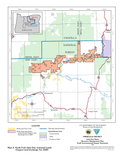
Birdet al.' MagneticsOver theGrenadaBasin
64øW
62øW
1269
60øW
550.88
•oo.•
3a•.ae
zse.ea
z
....
5a.eaa
........
........
:::::;::
::::::::
-50.eee
::::::::
-t00.90
::::::::
-•50.60
-250.06
-368.00
-350,66
-asa.
z
o
lOO
2oo
aa
krn
Fig. 2. Total intensitymagneticanomaliesover the studyarea. The contourintervalis 50 nT. Gridded
data (2 kin.)were compiledin !987 by _theGeologicalSocietyof AmericaDecadeof North American
GeologyCommitteeon theMagneticAnomalyMap of NorthAmerica.
1982; and Westbrook, 1975]. The Basin is bounded to the
north by the Saba Bank at the junction of the Greater and
LesserAntilles and to the southby the continentalrise of
northern Venezuela. The Aves Swell and the Lesser Antilles
arc form the western and eastern limits of the basin. The
shapeis arcuateand hasapproximatedimensionsof 640 km
(north-south)by 140 km (east-west)and an averagewater
depthof about2 to 3 km. Sedimentthickness
rangesfrom 2
km in thenorthto 9 km in thesouth[Bouysse,1988].
Morphologically,the oceanfloor of the GrenadaBasinfalls
into northernand southernparts. The bathymetryof the
northern
parthasbeendescribed
by Bouysse
[1988,p. 123]as
"ruggedwith a systemof spursand valleysrunningdown
fromtheLesserAntillesvolcanicarc." Thesouthern
partof
1270
Birdet al.: MagneticsOvertheGrenadaBasin
the basin is characterized by a near horizontal, smooth
seafloor. The natureof the deep sedimentsof the Grenada
•
North
American
Plate
Basin is not known but refraction data indicate that sediments
of the Aves Ridge extend and thicken into the Basin
[Westbrook, 1975].
The Aves Swell, an extinct island arc [Bouysse, 1984,
1988],occupiesthewesternsideof thebasin. Its westernedge
strikesnorth-south
anddipssteeplyinto theVenezuelanBasin.
Its easternedge is arcuate and descendsin stepsinto the
Grenada Basin. Fox and Heezen [1975] report on dredge
samplesrecoveredfrom pedestalsand scarpsof the Aves
Ridge. Dredgedvolcanic rocks include andesires,basalts,
dacites,and volcanicbreccias. Farthersouthalong the ridge,
Late Cretaceousto Paleocenegranodiorites,diabases,and
basaltshavebeendredged[FoxandHeezen,1975].
Four drilling sitesare locatedin the generalarea (Figure 1).
Two Deep Sea Drilling Project(DSDP) wells were drilled in
the southernpartof theAves Swell,and two wellsweredrilled
by MarathonOil Companyon the SabaBank. DSDP wells
Caribbean
a)
South
American
Plate
•
North
30 and 148 encountered middle to late Miocene volcanic sands
American
Plate
[ShipboardScientificParty, 1970]andpossiblyPaleoceneage
volcanics[ShipboardScientific Party, 1973], respectively.
MarathonOil Company'sSB-1 and SB-2 wells in the northern
part of the basin encounteredearly Paleoceneto early
Oligoceneandesite[Warner,1991].
The Grenada Basin is borderedto the east by the active
Lesser Antilles island arc which, like the Aves Swell on the
westernmarginandtheGrenadaBasinitself,formsa gentlearc
concave to the west. The Lesser Antilles splits north of
approximately15øNinto an innerandan outerarc (Figure 1).
The outerarc is older (35-15 Ma) and inactive,while the inner
arcis younger(20 Ma to recent)andpresentlyactive[Fox and
Heezen, 1975]. A maximum separationof about 50 km
perpendicularto the arcs occurat the northernlimit of the
bifurcated island chain.
The inner and outer arcs of the Lesser Antilles have been
named the "Volcanic
Caribbees"
and the "Limestone
Caribbean
Plate
It
b)
South
American
Plate
Caribbees," respectively[Martin-Kaye, 1969]. Lower Mioceneto earlyPliocenebasalt-andesite-dacite
seriesvolcanicsare
dominant rock types of the northernpart of the Volcanic
Caribbees(northof 15øN)and pre-Mioceneto recentvolcanics
are dominant in the southernpart [Fox and Heezen, 1975].
The LimestoneCaribbeesare characterizedby middleOligocene to Miocene andesires,dacites,tuffs, and agglomerates
intrudedby dioriteandquartzdiorite[FoxandHeezen,1975].
Late Jurassicage basaltsare reportedby Fink [1968, 1970]
on the islandof la Desirade,just eastof Guadeloupe.These
rocksmay representobductedoceaniccrust [Bouysse,1988;
Fox and Heezen, 1975; Mattinson et al., 1980] or evidencefor
early developmentof the MesozoicArc [Burke, 1988]. Other
interpretationsinclude the possibilitythat theseolder rocks
may be related to the same tectonicevent which shiftedthe
North
American
Plate
center of volcanism westward from the Limestone Caribbees.
South
PREVIOUS
Plate
INTERPRETATIONS
Kinematicmodelsfor the formationof the GrenadaBasinby
Bouysse[1988], Pindell and Barrett [1990], and Tomblin
[1975] outline the formation of the basin by northeastsouthwest extension, north-south extension, and east-west
extension,respectively.
East-West
American
O•
300 km
Fig. 3. (a) Possibleeast-westextensiondue to an westward
shiftof the Aves Ridge for the openingof the GrenadaBasin
as proposedby Tomblin [1975]. Large arrowsindicatethe
relative motionsof the North American, Caribbean,and South
American plates. Small arrows indicate the directions of
exten-sionfor the formationof the basin. (b) Possiblenorth-
Extension
Tomblin [1975] describes two possible scenarios for
east-westextension; the first involving an early Tertiary
southextensionfor the openingof the basinas proposedby
Pindell and Barrett [1990]. (c) Possiblenortheast-southwest
eastward
extension
for theopeningof thebasinasproposed
by Bouysse
shift of the subduction
zone and the second a
westwardshift of the Aves Ridge. He pointed out that the
[1988].
Bird et al.: MagneticsOver theGrenadaBasin
westward seperationof the Volcanic Caribbees from the
Limestone
Caribbees
in the Miocene
is not related
to the
eastward shift of the subduction zone, that is; extensional
strainswhich give rise to the formationof the GrenadaBasin
in early Tertiary no longer exist and compressionalstrains
havedominatedin the late Tertiary. In this model,olderrocks
of la Desiradeare either part of an older orogenyand moved
eastwardwith the subduction
zoneor part of theAtlanticfloor
obductedontothe eastwardmovingCaribbeanplate.
Tomblin'salternativescenarioinvolvinga westwardshift of
the Aves Ridge requires the formation and subsequent
spreadingfrom a north-southorientedmedianridge (Figure
3a). He reportsthat no suchridge has been observed. The
moreprobablescenariois the westwardmigrationof the Aves
Swell away from the subductionzone.
anomalies
(2 km) werecompiledin 1987by theGeological
Societyof AmericaDecadeof NorthAmericanGeology
(DNAG) Committeeon the MagneticAnomalyMap of North
America.Figure4 showsthecoverageof shipboard
magnetics
profiledatafor the studyarea. For the mostpart, the profile
magneticdatasetwasleveledandcontoured,
thendigitizedto
createtheDNAG griddeddatasetsusedfor thisstudy.
Magnetic anomaliesover the GrenadaBasin (Figure 2)
exhibit amplitudesof severalhundrednanoteslaswith wavelengthsrangingfrom 10 to over 50 kin. Anomaliesover the
southernpart of the basindisplaylongerwavelengthsand
smalleramplitudesthan thoseover the northernpart. Similarly, shapesand trendsof anomalieschangefrom north to
south. The shapeof the anomaliesoverthe northernpart of
the basin is typically oblong with an east-westtrend and
degradesto patchyand disorganizedto the south. Magnetic
anomalies
North-South Extension
Pindell and Barrett [1990] describeda model in which the
LeewardAntilleshavebeencoupledto thenorthernedgeof the
SouthAmericanplate(Figure3b). North-south
spreading
in
the vicinity of the GrenadaBasinwas a resultof oblique
convergence
with the SouthAmericanplate. The basinwas
thusformedby rightlateralshear.In thismodelthe Leeward
Antilleswaspartof theAvesRidgepriorto theformationof
the basin and representsfragmentation of the arc as the
Caribbeanplate progressedeastward. Pindell and Barrett
[1990] suggestthat the generaleast-west,or perpendicularto
the island arc, orientation of magnetic anomalies over the
basin supportnorth-southextension. For this model, differ-
1271
over the Aves Swell
are similar
to those of the
northernpart of the basinexceptthat they are orientednorthsouth.The magneticanomaliesover theLesserAntillesrange
in amplitudefrom 150 to 600 nanoteslasand display wavelengthsrangingfrom 5 to 40 km.
ANALYSES
Analyses
of thedataincludeda qualitativeinterpretation
of
theDNAG anomalyfield, correlation
of anomalyhighsand
lowsfromtwo-dimensional
(2-D) anomalyprofiles(i.e.,trend
analysis),
andforwardthree-dimensional
(3-D) modeling.A
large percentageof anomaliesover the GrenadaBasin have
aspectsratioslessthan 5:1, hence3-D modelingis most
ences in the nature of the crust of the northern and southern
appropriate.
partsof thebasinareimportant.It is suggested
thatthenorthem partis blockfaultedwith no development
of oceaniccrust,
whereasthe southernpart of the basinis probablyunderlain
by oceaniccrust[PindellandBarreu,1990].
Severallow-amplitude
(approximately
30 nT) magnetic
anomaly
trendsfrommagnetic
profiledata,oriented
subparallel
totheLesserAntillesarc,aredefinedoverthesouthern
partof
the basin (Figure 5). Anomaly trendsare orientedboth
Northeast-Southwest
partof thebasin. AnomalytrendsovertheAvesRidgeare
orientednorth-south.Figure6 displaysselectedmagnetic
parallel and perpendicularto the islandarc over the northern
Extension
Bouysse [1988] describes a possible mechanism for
extension,quite like Pindell and Barrett's,in which coupling
of the southernpart of the LesserAntilles with the South
AmericanPlate alsoprecedesopeningof thebasin(Figure3c);
however,the mechanismof backarc spreadingin thismodelis
similar to a mechanismdescribedby Poehls [1978]. He
suggested,
as did Burke [1988] andPindellandBarrett[1990],
that the Netherland-Antilles,
the Lesser Antilles, and the
GreaterAntilles formeda continuousMesozoicarc prior to the
injectionof the Caribbeanplatebetweenthe Americanplates.
Bouysse [1988] further suggeststhat subsequentseafloor
spreadingwas orientednortheast-southwest
at the onsetof the
Cenozoicin a segmentedmannersuchas describedby Tamaki
[1985] for the Sea of JapanBasin. Initial spreadingwas in the
southernmost
partof the basinandgraduallyprogressed
north-
anomalyprofiles over the southernpart of the basin with
someof the majoranomalytrendsindicated.Note thatseveral
trends,althoughdiscontinuous,
are orientedgenerallynorthsouth,or concentricto the island arc and the trench line of the
subruction zone.
Speedet al. [1984] mappedan acousticbasement
surfacein
time utilizingextensivemultipleand single-channel
seismic
reflection
datasets.Although
acoustic
basement
andmagnetic
basementmay not coincidein regionsof continentalcrusts,
these surfacesshould coincide for oceanic crust. In order to
constructa 3-D magneticmodel for the GrenadaBasin,the
acoustic
basement
surfacetime contours
weredigitizedand
convertedto depth. The velocityfunctionutilizedto convert
the time horizonto depthwas determinedfrom the LamontDohertyGeologicalObservatorycruiseRC1904, line 15
velocityanalyses
andrefractionline 29 [Officeret al., 1957].
ward over time.
Time-depthcurveswere calculatedat even incrementsacross
Bouysse's
modelprovidesfor contemporaneous
formation
of theYucatanandGrenadabasins.This development
occurred
when the Caribbeanplate, travelingnortheastwi'threspectto
the North American Plate, was wedgedbetween the North
AmericanandSouthAmericanplatesin lateCretaceous/early
Tertiarytime. Subsequent
to thisdoublecollision,the Caribbeanplate rotatedclockwiseand begantravelingin an east-
thebasinfrom line 15. Thesecurveswerecombined,anda
bestfit curvewasinterpreted.At theintersection
of reflection
west direction.
DATA
BASE
The databasefor thisstudyincludesbothprofileandgridded
magneticanomalies. The griddedtotal intensitymagnetic.
line i 5 andrefraction
profile29 thelowerpartof thebestfit
curvewasforcedtotiewiththerefraction
data.Thisvelocity
functionwasthenusedto calculateddepthsfor the entire
basin.For thefirst-ordertectonicproblemstudiedhere;that
is, the orientation
of extension
andopeningof theGrenada
Basin,the resultantbasementsurfacein depthshouldbe
sufficiently
accurate.Subtracting
theforwardcalculated
field
from the observedfield removesthe effect of basementrelief
andresults
in a residual
anomaly
fieldproduced
onlyby
changes
in magnetization,
including
geomagnetic
polarity
reversals.
1272
Birdetal.: Magnetics
OvertheGrenada
Basin
64'W
62øW
60'W
ß
..
..
..
0
100
200
k!TI
Fig.4. Shipboard
magnetics
datacoverage
for thestudyarea.Anomaly
profiles
for west-northwest
oriented
shiptracks
outlined
bythedashed
boxaredisplayed
inFigure6.
INTERPRETATION
Anomaliesnorth of 14øNare betterdefined than thoseto the
south(Figure2) because
of thesouthward
deepening
of the
basement.
Foranymagnetized
bodythereexistsa straightforward
relationship
between
thewavelength
of itsmagnetic
anomalyandthedistance
fromthebodyßTherefore,
asthe
basementdepthincreases,anomaliesover the basinbecome
longerin wavelength
andsmaller
in amplitude
andbeginto
interferewithoneanother.Suprabasement
effects,or structural
reliefof thebasement
surface,
as well asintrasedimentary
sources
typicallyproduce
relativelysmallamplitude
anomalies
(tensof nanoteslas).
However,
if thestructural
reliefis large
enough(kilometers),
anomalies
canrangein thehundreds
of
nanoteslas.
Anomaliesproducedwithin the basement,or
intrabasement,
usuallyexhibitlargeramplitudes
(hundreds
of
nanoteslas).Thereforein general,short-wavelength,
small-
amplitudeanomaliesare interpretedto be producedby
shallower
intrasedimentary
or shallowsuprabasement
sources,
andlong-wavelength,
high-amplitude
anomalies
areinterpreted
to be producedby deeperintrabasement
featuressuchas
lithologicboundaries
or boundaries
relatedto geomagnetic
polarityreversals.
However,thesegeneralrulesmayhaveimportantexceptions
in areascharacterized
by low geomagnetic
inclinations(lessthan30').
Thenorth-northeast
to north-south
orientation
of anomaly
trendsover the basinsouthof 14'N are interpretedto be
producedby seafloorspreadingand indicatea neareast-west
directionof extensionand openingof the GrenadaBasin.
Althoughtheseanomalies
exhibitamplitudes
of about40 nT,
Bird et al.' MagneticsOver theGrenadaBasin
0
100
200
1273
krn
Fig.5. Magnetic
anomaly
trends
overthestudy
areafromprofiledata.Anomaly
highs
areindicated
by
plussigns
withcontinuous
plussigns,
pairsof plussigns,
andsingle
plussigns
corresponding
togood,
fair,andpoorcorrelations,
respectively.
Anomaly
lowsareindicated
bysolid,dashed,
anddotted
lines
whichcorrespond
togood,fair,andpoorcorrelations,
respectively.
confidencein these t_rendsis high. Thi• cnnfidanco.iq
supported
by two aspects
of theregionandthe magneticfield.
First,thetrendswerecorrelated
usingdatafroma singlecruise
(U.S. Navy WI932010) with 18 linesspacedapproximately
8
km apart.Second,
theacoustic
basement
surfacein thispartof
the basin is relatively smooth,suggestingintrabasement
sourcesare responsiblefor the anomalytrendsobservedin
and Waqthrnnk [1984] q-_•_•o.
st that the momhn!n•v nf the.
northernpan of thebasinis apparently
controlledby a NW-SE
horstand grabensystemandpossibleright lateralstrike-slip
motion.
profiles. Trendsover the northernpart of the basinmay
The magneticfield calculated
for a constant
susceptibility,
3-D model (a singlebasementhalf- space)producesstrong,
subparallelto the arc anomaliesover the southernpan of the
basin(Figure7a). The magneticsignatureover the northern
possiblyhavebeendevelopedas a resultof the tectonicevent
responsible
for thebifurcafionof thenorthernLesserAntilles.
That is, the originalmagneticsignature
is thoughthavebeen
disrupted
by faulting,andpossiblestrikeslipmotion. Speed
part of the modelis relativelyquiet, with only a few highamplitude(greaterthan100nT) anomalies.Theresidualfield
(Figure7b) displaysanomalies
orientednorth-south
to northeast-southwest
in the southernpart of the basinbut mostly
1274
Birdet al.: Magnetics
OvertheGrenadaBasin
50
nT
L
,50
nT
L
lO
lO
•m
a)
km
b)
Fig.6. Anomaly
profiles
overthesouthern
partof thebasin.Sometrends
areindentified
in 6b). The
locationof theprofilesis shownin Figure4.
irregularpatternsover the northernpart of the basin. The
anomalies
overthesouthern
partof thebasinareinterpreted
to
be producedby seafloorspreadingand the formationof the
GrenadaBasin. Anomaliesover the northernpart are interpretedto bepossiblydueto seafloorspreading
butdisrupted
by
recent tectonic movements.
DISCUSSION
In his discussion
regardingthe magneticanomaliesover the
Grenada
Basin,Bouysse
[1988]pointsoutthatthegreatdepth
to the oceanicbasementcombinedwith a possiblelocation
nearthe geomagnetic
equatorof the easternCaribbeanmay
the basinformeddin Late Cretaceous
to early Tertiarytime
[Hall andYeung, 1980]. Hall and Yeung furthersuggestthat
the Yucatan Basin formed by back arc extension form a
northeastorientedspreadingcenter. This orientationob back
arc spreading
resultsfrom sheafingof Cubapastthe Yucatan
Penninsulawith the spreadingcenterorientedapproximately
normalto the trendof the shearzone. East-westspreadingin
the GrenadaBasin with sheafingpast SouthAmerica may
representa similarmechanism.
To illustratethe dependence
of magneticanomalydataon the
geomagneticinclinationand strike of the sourcebody, four
profiles have been calculated utilizing two geomagnetic
inclinations
and two strike
directions
for the 2-D
model
blur the originalanomalypattern. Theseobservations
are the
primaryreasonfor the confusionregardingthe magneticfield
overtheGrenadaBasin. The 3-D residualmagneticsremove
(Figure8). Mostplatereconstructions
placethe leadingedge
of the Caribbeanplate at approximately12ø latitude at the
time thebasinformed[Duncanand Hargraves,1984;Ghoshet
the effectof structural
relief on the deepbasement,
leaving
al., 1984; Pindell et al., 1988; and Ross and Scotese, 1988].
anomaliesproducedby lithologic variationsand boundaries
resultingfrom geomagnetic
polarityreversals.A drawbackof
our analysisis the lack of susceptibilityinformation,but the
choiceof susceptibilityusedin modelingappearsto affect
A paleomagneticinclination is calculated, to simulate a
remanentinclinationand hopefullyresolveanomaliesproduced
by this remanent field utilizing the relationship [Sharma,
only anomalyamplitudes,and not the anomalypatterns
themselves. Forward 3-D magnetics,calculated with a
constantsuscepti-bilityof 13,000 micro cgs unitsproduces
tan (inclination)= 2 tan (latitude)
anomaly patternssimilar to thoseobtainedwith 8000 micro
cgs units.
MagneticanomalydataovertheYucatanBasinsuggest
that
1976]:
Thisformulayieldsa valueof about23ø. A paleodeclination
of 0ø is also used.Two profiles were orientedsouth-north
acrossan east-westtrendingbody, and the other two were
oriented
west-east
overa north-south
trending
body.
Birdetal.' Magnetics
OvertheGrenada
Basin
64øW
1275
62øW
60øW
::::
50. 888
::::
::::
....
.....
::::::::
.....
iiiiiiii
:::::
:::::
:::::.
-2ae.ee
......
......
-555,
o
lOO
200
8•
km
Fig.7.(a)Magnetic
anomalies
overthestudy
area
calculated
fromathree-dimensional
model
withlayers
of uniformmagnetic
susceptibility.
Thecontour
intervalis 50 nT.
An amplitudedecreasefrom south-northto west-east
calculations
using43' inclinationis about57% (from about
300 to 130 nanoteslas). A more dramatic,and importantto
thisstudy,decrease
is observed
from south-north
to west-east
calculations
using23' inclination.The decrease
in amplitude
is about86%, or over a sevenfolddecrease(from about290 to
40 nanoteslas).
Anomaliescorrelatedfrom the observedprofile magnetic
dataover the southernpart of thebasinexhibitamplitudesnear
40 nanoteslasand theredoesnot appearto be structuralrelief
on the acousticbasementsurfacewhich would producethese
anomalies. Furthermore,the 40 nanoteslasamplitude for a
north-southorientedbody indicatesthat magnetizationof the
body is causedprimarily from the remanent field (or 23ø
1276
Birdet al.: MagneticsOvertheGrenadaBasin
60øW
62øW
64øW
I
•00.08
35e.
ea
250,88
[5e.aa
-50.909
-t09.99
-200.89
-250.96
-399.66
-359.96
-909.66
-450.96
-500.66
-650.69
/
o
lOO
2oo
krn
Fig.7. (b) Totalmagnetic
intensity
(Figure1) minuscalculated
magnetic
anomalies
overthestudyarea.
The contour interval is 50 nT.
incl{nation).
Thisis because
anyeffectof theinducing
field
wouldonly increasetheamplitude,sincethewest-eastprofile
at 43ø inclinationproducesa largeramplitudeanomaly(i.e.,
130 nanoteslas).The effectof magnetizationcontrastscaused
by geomagnetic
polarityreversals
alsoincreases
theamplitude
of anomalies.
At low geomagneticinclinations,east-westtrending
featuressuchastransformfaultswhichhavebeeninjectedwith
magnetizedmaterialor the endsof offset spreadingridge
segments,
wouldproduce
anomalies
of hundreds
of nanoteslas.
However,a north-south
trendingridgesegmentwouldproduce
anomaliesof only tensof nanoteslas.At themagneticequator
a north-south
ridgesegment
wouldproduceno anomaly.
A 3-D, variablesusceptibilitysurfaceis generated(Figure
9a) on the basisof resultsfrom the interpretationof the total
intensitymagneticanomaliesand the magneticsprofile trend
Birdet al.' MagneticsOver theGrenadaBasin
Profile
Direction
Magnetic
Inclination
I
2
3
south-north
south-north
west-east
43
23
43
4
west-east
23
1277
the anomalypatternsthey produce. The magneticanomaly
patternsovertheGrenadaBasinandourinterpretation
of them
demonstrates
this dependence.The GrenadaBasin is interpretedto haveformedby neareast-west,or subparallelto the
islandarc, extensionin the early Tertiary. This conclusionis
supportedby forward 3-D magneticsmodelingand subtle
magneticanomalytrendsover the southernpan of the basin.
These low-amplitude (about 40 nanoteslas)anomalies are
produced
by a roughlynorth-south
orientedspreading
center(s)
nearthe geomagneticequator. The chaotic,patchyanomalies
overthenorthernpan of thebasinare thoughtto haveformed
by seafloorspreading
also,but later weredisruptedby the late
Tertiary event responsiblefor the bifurcation of the Lesser
Antilles.
Althoughthe magneticdataover someareasof the Grenada
Basinare sparse,the authorsfeel that the presentdatabaseis
sufficientfor thepurposeof thisstudy. Additionaldatawhich
may help define the orientation of extensionin the basin
include the acquisitionof seismicrefractionand/or seismic
reflectiondata. Existingrefractiondatafor thenorthernpan of
the basin consistsof a single, relatively short, unreversed
profile [Speedet al., 1984]. Additionaldataheremay help
definethe crustalarchitectureof this part of the basin. The
correlation of similar features on the western flank of the
[
•
64'w
62'w
60'W
tK,BOO0
::i:!:i'.!
I
, ,I
i
t
lol0
i
I
,•
I
•oo
C)ISTANCEIKM)
Fig. 8. Magneticanomaliescalculatedfor two inclinations
(23' and43') andtwoprofiledirections
(south-north
andwesteast).In eachcalculation,
thesametwo-dimensional
causative
bodywasused: 5 km thick,at 12 km depth,and8000 micro
cgsunitssusceptibility
magnetization.
analysis. The variable susceptibility surface is then
incorporated
in a 5-kin-thickbasement
layer,andthemagnetic
field is calculated(Figure 9b). Susceptibilities
of +8000,
-8000, and 2000 micro cgs unitsare assumedfor normally
magnetized
oceanic
crust,reversely
magne-tized
oceanic
crust,
andarcmaterial,respectively.Thepurpose
of thisexerciseis
to testthehypothesis
thatnearnorth-south
spreading
centers
mayproduce
small-amplitude
anomalies
relativeto east-west
orientedtransformfault zones. The magnetizationvector
assigned
to themodelcoincides
witha paleoinclination
and
paleodeclination
of 23' and0ø,respectively.The calculated
fieldutilizespresent-day
inclination
anddeclination
of 43' and
-11ø. Inspection
of Figure9b revealsthateast-west
features
produce
anomalies
withamplitudes
2 to4 timesaslargeasthe
north-southtrendingridge segments. If the geomagnetic
inclination was less than 23 øwhen the Grenada Basin formed,
thenthe ratio of anomalyamplitudesproducedby east-west
versusnorth-south
featureswouldbe greater.
On thebasisof our 3-D analysis,we attributethe prominent
east-west
trendinganomalies
of theGrenadaBasinto fracture
zonesformedduringseafloorspreading
at low latitude. This
east-westtrend is not interpretedas indicatingnorth-south
extension of the basin.
CONCLUSION
Interpretation
of magnetic
anomalies
at low geomagnetic
inclinations
depends
onthestrikeof thegeologic
features
and
o
lOO
200
km
Fig. 9. (a) Variablesusceptibility
surfacewhichincorporated
in a 5-km-thick basementlayer to generatea variable
susceptibilitymodel. The dashedlines indicate possible
spreadingcenters. The identificationof normal polarized
oceanic(+8000 micro cgs units),reversedpolarized(-8000
microcgsunits),and arc crust(+2000 microcgsunits)are
shownby plus,white,anddottedpatterns,respectively.
1278
Birdet al.: Magnetics
OvertheGrenada
Basin
60'W
62øW
64øW
850.88
700.88
850.88
550.88
500.88
35•.88
i
300.80
250.•8
B.089
-50.600
-100.60
-150.
e•
-258.88
i
-358.88
-78•.88
i
I
o
!
lOO
I
200
km
Fig.9. (b)Calculated
magnetic
anomalies
fromthevariable
susceptibility
model.Thecontour
interval
is
50 nT.
LesserAntilles with the easternflank of the Aves Ridge, by
either seismic reflection or geologic means, may lead to
furtherevidenceregardingthe orientationof extensionand
subsequent
development
of thebasin.
Acknowledgment. The authors would like to thank
MarathonOil Companyfor contributingthe datausedin this
studyas well as the useof Marathon'scomputersystemand
software.
Birdet al.' Magnetics
OvertheGrenada
Basin
1279
REFERENCES
Bird, D. E., S. A. Hall, J. F. Casey, and P.
S. Millegan, Integrated geophysical
interpretationof the Grenada Basin: in,
61st Annual Internaternational Meeting
Expanded Abstracts,
pp. 172-178,
Society of Exploration Geophysicists,
Houston, Texas, 1991.
Bouysse, P., The Lesser Antilles arc:
structure and geodynamic evolution,
Initial Rep. Deep Sea Drill. Proj. 78A,
83-103, 1984.
Bouysse,P., Openingof the Grenadabackarc basin and evolution
of the Caribbean
plate during the Mesozoic and Early
Paleocene, Tectonophysics, 149, 121143, 1988.
Boynton,C. H., G. K. Westbrook,M. H. P.
Bott,
and R. E. Long, A seismic
refraction investigation of crustal
structure
beneath
the
Lesser
Antilles
island arc, Geophys. J. R. Astron. Soc.,
58, 371-393,
1979.
Geology, Elsevier Science, New York,
Fox, P. J., and B. C. Heezen, Geology of
the Caribbean crust, in The Ocean Basins
and Margins, vol. 3, edited by A. E. M.
Nairn and F. G. Stehli, pp. 421-466,
Plenum, New York, 1975.
1970.
Ghosh, N., S. A. Hall, and J. F. Casey,
Seafloor spreadingmagnetic anomaliesin
the
Venezuelan
Caribbean-South
Basin,
American
in
Plate
1976.
Hall, S. A., and T. Yeung, A study of
magneticanomaliesin the YucatanBasin,
Conf.,
9th, 519-
Mrozowski, and T. Watanabe, Crustal
1978.
Burk, K., Tectonic evolution of the
Caribbean, Annu. Rev. Earth Planet Sci.,
16, 201-230, 1988.
Jarrard, R. D., Relations among subduction
parameters,Rev. Geophys., 24, 217-284,
Burke, K., C. Cooper, J. F. Dewey, W. P.
Ludwig, W. J., J. E. Nafe, and C. L. Drake,
Seismicrefraction, in The Sea, vol. 4, pt.
1, edited by A. E. Maxwell, pp. 53-84,
John Wiley, New York, 1971.
Martin-Kaye, P. H. A., A summary of the
geologyof the LesserAntilles, Overseas
Mann,
and J. L. Pindell,
Caribbean
tectonics and relative plate motions, in
The
Caribbean-South
American
Plate
Boundaryand Regional Tectonics, edited
by W. E. Bonini et al., Mem. Geol. Soc.
Am., 162, 31-63, 1984.
Case, J. E., T. L. Holcombe, and R. G.
Martin, Map geologic provinces in the
Caribbean region, in The CaribbeanSouth American Plate Boundary and
Regional Tectonics, edited by W. E.
Bonini et al., Mem. Geol. Soc. Am., 162,
1-30, 1984.
DeMets,C. et al., NUVEL-I: A new global
plate motion data set and model
(abstract),Eos Trans. AGU, 66, 368-369,
1985.
Mineral.
Resour.,
of the Caribbean
and Gulf
of Mexico.
Somecriticalproblemsand areas,in The
OceanBasinsand Margins, edited by A.
E. M. Nairn and F. G. Stehli, 3, pp. 663689, Plenum, New York, 1975.
Duncan,R. A., and R. B. Hargraves,Plate
tectonic
evolution
of
the
Caribbean
region in the mantle reference frame, in
Caribbean-South
American
Plate
BoundaryandRegionTectonics,editedby
W. E. Bonini et al., Mem. Geol. Soc.
Am., 62, 81-93, 1984.
Edgar, N. T.,
Seismic refraction and
reflection in the Caribbean Sea, Am.
Assoc. Petr. Geol. Bull., 55, 833-870,
1971.
Ewing, J. I., C. B. Officer, H. R. Johnson,
and R. S. Edwards, Geophysical
investigationsin the eastern Caribbean:
Trinidad Shelf, Tobago Trough, Barbados
Dirl•
Atl•t•tOcean, t•.•r•l
Bull., 68, 897-912, 1957.
•r•r' Arn
Fink, L. K., Marine geology of the
Guadelouperegion, Lesser Antilles arc,
Ph.D. dissertation, Univ.
Miami, Florida, 1968.
of
Miami,
Fink, L. K., Field guide to the island of La
Desirade with notes on the regional
history and development of the Lesser
Antilles
island
arc,
Guideb.
to
Caribbean
the
Int.
Field
Inst.
Island-Arc
System,N. S. P., Am. Geol. Inst. N. S.
P., WashingtonD.C., pp. 287-302,1970.
10,
172-206,
1969.
1991.
Speed, R. C., et al., LesserAntilles arc and
adjacentterranes,Atlas 10, OceanMargin
Drilling Program, Regional Atlas Series,
27 sheets, Mar. Sci. Int., Woods Hole,
Mass., 1984.
Tamaki, K., Two modes of back-arc
spreading,Geology, 13, 475-478, 1985.
Tomblin,
J. F., The Lesser Antilles
and
Aves ridge, in The Ocean Basins and
Margins, vol. 3, editedby A. E. M. Nairn
and F. G. Stehli, 467-500, Plenum, New
York, 1975.
Torrini, R., Jr., and R. C. Speed, Tectonic
wedging in the forearc basin-accretionary
prism transition, Lesser Antilles Forearc,
J. Geophys. Res., 94, 10,549,-10,584,
1989.
Martinson, J. M., L. K. Fink, Jr., C. A.
Hopson, Geochronologic and isotopic
study of the La D6sirade Island basement
complex: Jurassic ocean crust in the
Lesser Antilles?, Contrib.
Petrol. 71, 237-245, 1980.
Mineral.
Officer, C. B., J. I. Ewing, R. S. Edwards,
and H. R. Johnson,Geophysicalinvestigations in the eastern Caribbean: Venezuelan Basin, Antilles
Donnelly, T. W., The geological evolution
The
1986.
Geol.
crust of the Grenada Basin in the southern
LesserAntilles arc platform, J. Geophys.
structure,in A GeophysicalAtlas of East
and SoutheastAsian Seas, edited by D. E.
Hayes, Map Chart. Ser. Geol. Soc. A.,
MC-25,
Speed, R. C., and J. A. Walker, Oceanic
Res., 96, 3835-3851,
Hayes, D. E., R. E. Houtz, R. D. Jarrard,C.
L.
of the Caribbean
plate by Sn waves from earthquakes,
Trans. Conf. Geol. Caraibes, 7th, 87-91,
E. Bonini et al., Mern. Geol. Soc. Am.,
162, 65-80, 1984.
Geol.
Shipboard Scientific Party, Site 148,
Initial Rep. Deep Sea Drill. Proj., 15,
217-275, 1973.
Shurbet, D., Definition
The
Bound-
ary and Regional Tectonics, edited by W.
Trans. Caribb.
526, 1980.
1976.
ShipboardScientific Party, Site 30, Initial
Rep. Deep Sea Drill. Proj., 4, 215-241,
Island Arc, and
Puerto Rico Trench, Geol. Soc. Am. Bull.,
68, 359-378, 1957.
and D. E. Miller,
1982.
Uyeda, S., and H. Kanamori, Back-arc
opening and the mode of subduction,J.
Geophys.Res., 84, 1049-1061, 1979.
van der Hilst, R. D., and E. R. Engdahl,On
ISC PP andpP data and their use in delaytime tomography of the Caribbean
region, Geophys.J. lnt., 106, 169-188,
1991.
Officer, C. B., J. I. Ewing, J. F. Hennion,
D. G. Harkrider,
Uyeda,
S., Subduction
zones: an
introduction to comparative subductology, Tectonophysics, 81, 133-159,
Geo-
physical investigations in the eastern
Caribbean: summary of 1955 and 1956
cruises, Phys. Chem. Earth, 3, 17-109,
1959.
Wadge, G., and J. B. Sheperd,
Segmentation of the Lesser Antilles
subduction zone, Earth Planet. Sci. Lett.,
71, 297-304, 1984.
Warner, A. J., Jr., The Cretaceous age
sediments of the Saba Bank and their
Pindell, J. L., and S. F. Barrett, Geological
evolution of the Caribbeanregion; a plate
petroleumpotential,Trans. Caribb. Geol.
tectonic perspective, in The Caribbean
region, Decade of North American
Geology, vol. H, edited by G. Dengo and
J. E. Case, pp. 405-432,Geol. Soc. Am.,
Weissel, J. K., Magnetic linearions in
marginal basins of the west Pacific,
Boulder, Colo., 1990.
Westbrook, G. K., The structure of the crust
Pindell, J., and J. F. Dewey, Permo-Triassic
reconstructionof western Pangea and the
evolution
of the Gulf
of Mexico-Carib-
Conf., 12th, 341-354, 1991.
Philos. Trans. R. Soc. London,
223-247, 1981.
A300,
and upper mantle in the region of
Barbados
and
the
Lesser
Antilles,
Geophys. J. R. Astron. Soc., 43,
bean region, Tectonics, 1, 179-21 1,
201-242,
1975.
1982.
Pindell, J. L., S. C. Cande, W. C. Pitman
!!I• D. B. Rowley, J. F. Dewey, J.
LaBrecque, and W. Haxby, A platekinematic
framework
for
models
of
Caribbean evolution, Tectonophysics,
155, 121-138, 1988.
Poehls, K. A., !ntra-arc
basins:
a
kinamaticmodel, Geophys.Res. Lett., 5,
325-328,
Ross, M.
1978
I.,
r• c: n;.a
W,•rlcl G•.nqclence. Inc.. P.O.
Box 219357, Houston,TX 77218-9998.
J.F.CaseyandS.A. Hall, Department
of
Geosciences,University of Houston,Scienceand ResearchBuildingI, Houston,TX
77004.
P.S. Millegan, MarathonOil Company,
P.O. Box 3128, Houston,TX 77253.
and C. R. Scotese, A
hierarchical tectonic model of the Gulf of
Mexico and Caribbean region, Tectonophysics, 155, 139-168, 1988.
Sharma, P. V., Geophysical Methods in
(Received April 3, 1992;
revised April 22, 1993;
accepted April 29, 1993.)
© Copyright 2026 Paperzz