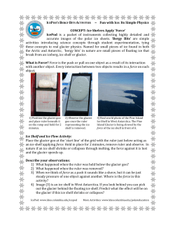
Causes of Arctic Sea Ice Loss and a Future Outlook: Possible Effects on Fisheries and Navigation Friday 27. May 2014, Bergen, 09:00 – 09:15 (10 min for questions) Lars H. Smedsrud Professor, Geofysisk Institutt CHALLENGES OF THE CHANGING ARCTIC: CONTINENTAL SHELF, NAVIGATION, AND FISHERIES Arctic icethickness Satellite based 2005-2007 Yearly means Snow Climatology [cm] 1954-1991 (winter: October-April) Svarte linjer 2 Zygmuntowska et al (2014) 3 Kwok & Untersteiner (2011) September Ice Extent, new IPCC models Stroeve et al. (2012) (updated for 2013) Sattellite Observations, “Best 17 models” Ice Extent, June 23. 2014 1981 – 2010 Median 5 National Snow and Ice Data Centre March Trends: 1979-2011 Representative for December - May Barents Sea Ice loss driven by Atlantic Heat March 1979 Smedsrud et al (2013) Explains much of the Arctic Sea Ice Loss during winter March 2006 Longest Temperature series in Arctic Ocean: Observed Kola Sectionocean temperature since 1900 Barents Sea cod stock 4500 4000 3500 3000 2500 The worlds largest cod stock Increased in recent years The spawning stock at alltime high 2000 1500 1000 Cod total stock 500 0 1946 1953 1960 1967 1974 1981 1988 1995 2002 2009 Cod spawning stock September Trends: 1979-2011 Representative for June - November Shipping along Russia northern coast: The Northern Sea Route cuts Hamburg Yokohama distance with 39% Days saved from Kirkenes and Murmansk Tschudi Shipping Company A/S First supertanker (Vladimir Tikhonov) sailed in 2011, cargo: 120,000 tonnes of gas condensate Sea Ice Age (simulations) 1981 - 2007 www-nsidc.colorado.edu Fram Strait export: high since 2004 2004-2009: 888.000 km² [Kwok, 2009] 1957-2010: 771.000 km² Difference equals area of Austria : 84.000 km² + Switzerland 41.000 km² [Smedsrud et al 2011] Arctic Column Model Nansen’s new hat Atmospheric Transport +3 W/m² “Direct effect” of Global warming Longwave radiation + 5 W/m² Ocean Transport +5 W/m² Increase in ice Export + 25 % (Smedsrud et al 2008) Simulated sea ice extent in 2100, RCP2.6 (fraction, year 2000, year 2100) March September Simulated sea ice extent in 2100, RCP8.5 (fraction, year 2000, year 2100) March September Summary: Loss of area (summer ~50%) and thickness (3.5m => 1.8m) Winter ice loss in Atlantic sector Four main reasons for ice loss: Radiation (Global warming) Atmospheric heat Oceanic heat Ice Export Earth system models are “good enough” An optimistic scenario “saves” the Arctic Sea Ice 16 Abstract Loss of Arctic sea ice has been documented for over 20 years, and is one of the most visible signs of ongoing global warming. Today summer sea ice extent has declined by about 50%, thickness hasreduced by about 40%, and the Northern Sea Route has become navigational waters for a limited time during summer. In 2100 the most pessimistic (business as usual) IPCC scenario has no summer ice left, while for the most optimistic IPCC scenario the Arctic sea ice cover remains roughly at today's level. What remains quite certain is that the "natural" variability will increase with a thinner ice cover, and that there are a number of negative feed-back processes operating protecting the ice, and preventing a so called "tipping-point" behaviour. The principal causes of the sea ice loss that has occurred will be summarized, and the scenarios for the future discussed. 17
© Copyright 2026 Paperzz