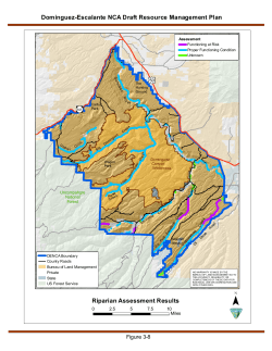
Smoke Dispersion modelling Mick Meyer The Centre for Australian Weather and Climate Research A partnership between CSIRO and the Bureau of Meteorology The Objectives 1. Include bushfire smoke in air quality modelling systems • • • Emissions Verification of the dispersion Exploration of potential for remote sensing 2. Process • Case studies of extensive fires 3. Human health impacts 1. 2. Exposure Health impacts (integration with fire DST) (Epidemiologists PhD candidate) 4. Improving current estimates of PM and GHG emission factors 5. Tools for planning of burning programs The Centre for Australian Weather and Climate Research A partnership between CSIRO and the Bureau of Meteorology Programs and Deliverables • 3 Case Studies • • • • 2006/7 Alpine fires Kilmore East (Black Saturday) and scenarios Regeneration burning in the Huon Valley (2003 alpine fires) (Complete) (Complete) (TAPM complete) • EF studies • Pyrotron simulations • 1 field measurement set (Complete, data analysis) (Complete) • Health Impacts • PhD is progressing well • Exposure: Fire DST • Technology transfer • How to use the current systems The Centre for Australian Weather and Climate Research A partnership between CSIRO and the Bureau of Meteorology Deliverables • 3 Papers • 1 complete, 2 are in draft • Firenotes • 3 are in near complete drafts. • Reviews and reports • Review of models is complete • EF studies delayed and now progressing • Technology transfer reports • Configuring TAPM • Inverse modelling to assess relative risk of impact for different source locations The Centre for Australian Weather and Climate Research A partnership between CSIRO and the Bureau of Meteorology MONTHLY EMISSIONS- DEC 06 FIRE EMISSIONS METHODOLOGY 1.0E+07 EMISSIONS (tonnes) BACKGROUND Fire area: daily area burnt; DSE Fuel load: VAST 1.5 (litter, coarse-wd); Efficiency: NGGI factors; Diurnal : Parameterised; Emission Factors: Literature; tonnes/hour CARBON MONOXIDE Fire Anthropogenic 10000 1000 100 10 4 6 8 10 12 14 16 18 Day Number 20 1.0E+05 1.0E+04 NOx HOURLY EMISSIONS- DEC 06 2 Fire 1.0E+06 1.0E+03 Plume Rise: prescribed 100000 Anthropogenic 22 24 26 28 30 CO VOC PM25 POLLUTANT SO2 TRANSPORT MODELLING METHODOLOGY Emissions: tracer; 600 Meteorology: Unified Model; Transport: Hysplit Brighton PM2.5 obs_conc no fires 2000 m 3000 m 1000 m 400 OR Emissions: speciated; 200 Meteorology: TAPM or CCAM; Transport: CTM 0 0 48 96 144 192 240 288 Prescribed plume rise 336 384 Time (h) 432 480 528 576 624 672 Elemental Carbon Brighton: ozone 160 120 obs_conc no f ires 2000m 3000 m 1000 m 20061204_1448 80 8TH December- hr 14 40 0 0 48 96 144 192 240 288 336 Time (h) 384 432 480 528 576 624 672 MODEL SENSITIVIES Plume Rise Emissions (transport) PM2.5 (mg m-3) (1000m – 2000 m) PM2.5 – peak daily for December 2006 O3- peak 1-h for December 2006 Hysplit- Hour 14 UTC 8th December 2006 O3 (ppb) (VOCext - VOCsav) Persistence Smoke Dispersion from Kilmore East 12 16 20 13 17 21 14 15 18 19 22 23 The Centre for Australian Weather and Climate Research A partnership between CSIRO and the Bureau of Meteorology Emission factor sampling Woozle Pyrotron Backpacks EFs CH4 9 EF_CH4 (% emitted C) kulgnuki 8 flaming 7 smoldering 6 kulgnuki_smouldering Logs 5 PM, total VOC Cow pats Woodheaters: VOC 50 Woodheaters:PM10 4 2 grass 1 0 0.60 0.70 0.80 0.90 1.00 MCE October - Eucalypt Woodland July -Eucalypt Woodland October - Sandstone Woodland July- Sandstone Woodland October- Spinifex July- Spinifex October- Sorghum N2O 1.4 EF N2O (% emitted N) 1.2 1.0 0.8 40 35 30 25 20 15 10 5 0 0.65 0.7 0.75 0.8 0.85 0.9 Combustion efficiency 0.6 0.4 0.2 0.0 0.86 Emission Factor (g (kg fuel)-1) litter 3 Kulnguki VOC 45 0.88 0.90 0.92 0.94 MCE 0.96 0.98 1.00 0.95 1 3.0 2.5 2.0 Logs 1.5 1.4 1.0 Litter 0.5 0.0 0.70 0.75 0.80 0.85 0.90 0.95 Modified Combustion Efficiency MCE ~ EF CO 1.00 N2O emission factor (% fuel N emitted as N2O) EF CH4 (% burned carbon emitted as CH4) Field Measurements Heyfield 1.2 1.0 0.8 0.6 0.4 0.2 0.0 0.70 0.75 0.80 0.85 0.90 0.95 Modified Combustion Efficiency The Centre for Australian Weather and Climate Research A partnership between CSIRO and the Bureau of Meteorology 1.00 Heyfield compares with Savanna 10 Gulf- Flaming Gulf -Logs Gulf - Cow pats Stirling curve regression Heyfield EF CH4 (% emitted C) 8 6 4 2 0 0.65 0.70 0.75 0.80 0.85 0.90 0.95 1.00 MCE The Centre for Australian Weather and Climate Research A partnership between CSIRO and the Bureau of Meteorology Lessons Learned 1. The models perform well 2. The challenge is to link the components of a system together • • Incompatible input & output formats Range of models with different strengths an weaknesses 3. The model run slowly/ require large computing power • Need a large UNIX cluster (~1000 processor machine) 4. Output from the review of models was that the Bluesky framework was worth exploring further. The Centre for Australian Weather and Climate Research A partnership between CSIRO and the Bureau of Meteorology
© Copyright 2026 Paperzz