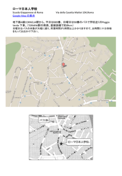
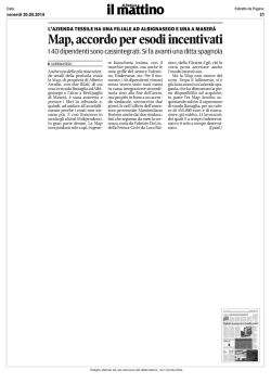
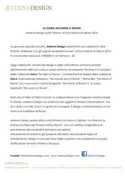
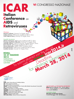
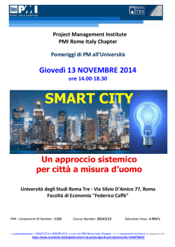
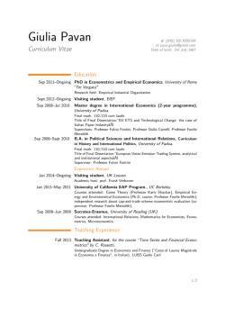
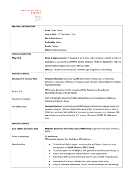
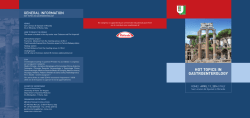
Humanist Studies & the Digital Age, 3.1 (2013)
ISSN: 2158-3846 (online)
http://journals.oregondigital.org/hsda/
DOI: 10.5399/uo/HSDA.3.1.3171
The GIS Forma Urbis Romae Project: Creating a Layered
History of Rome
James Tice, University of Oregon
Abstract: Using advanced GIS technology and accepted scholarly
methods, this multi-disciplinary project intends to create a layered
history of Rome by updating Forma Urbis Romae, the cartographic
masterpiece of ancient Roman topography published in 1901 by
archeologist Rodolfo Lanciani. This extremely accurate map measures
25 by 17 ft and uses an innovative graphic system that represents
Rome’s historic urban fabric as a series of transparent layers from
ancient to modern. The map remains the standard archeological
reference for Rome even though it does not incorporate archeological
discoveries uncovered since its original publication 100 years ago.
We plan to critically examine, update, and eventually republish the
map as an interactive website that will also serve as a dynamic
geo-database for scholars and others. Our project team will bring its
considerable experience in Web-based design in the study of the
humanities to ensure a highly intuitive product that is accessible,
interactive, and expandable.
The GIS Forma Urbis Romae Project is a long term, multi-disciplinary effort
involving archeology, art and architectural history, urban studies, cartography,
history, and geography. It proposes to explore important aspects of the
humanities using digital methods that can facilitate our understanding of history
and place. The subject of this inquiry is Rome, and the object of our
investigation is the cartographic masterpiece and pioneering study of ancient
Roman topography, Forma Urbis Romae (fig. 1). Published in 1901 by the Italian
archeologist Rodolfo Lanciani (1847-1929), this map sums up the rich cartographic
tradition to be found for Rome. Today it remains the standard archeological
reference for the city even though it does not incorporate the host of
archeological discoveries that have come to light since its original publication.
This phase of our work is being funded by an American Council of Learned
Societies Digital Innovation Fellowship for the academic year 2012-2013.
70
Humanist Studies & the Digital Age
Tice
Fig. 1. Forma Urbis Romae, detail, Rodolfo Lanciani, 1901
We are critically examining, updating, and eventually republishing a new
Forma Urbis Romae in the form of an interactive and dynamically evolving “geodatabase” that will document and represent the archeological foundations of the
city and their subsequent manifestations in later epochs. In addition to an
interactive digital product, our future plans contemplate print versions of the map
through periodic releases, or a print-on-demand feature, to record important
milestones in the ongoing investigation. Our goal for the Forma Urbis Romae
Project is to create an accessible, robust geo-database that will preserve
Lanciani’s map in digital form. As a dynamically evolving digital database it will
at once permit scholars to access information and invite them to contribute
archeological evidence as it is discovered so that the map will accurately update
and represent current research.
3.1 Spring 2013
71
Humanist Studies & the Digital Age
Tice
Fig. 2. La Pianta Grande, detail of the Campus Martius, Giambattista
Nolli, 1748
Background Description
Forma Urbis Romae was issued in installments from 1893 to 1901. The map
not only records the ancient city of Rome but also extensive cartographic detail
about subsequent historical epochs including Early Christian, Renaissance and
Baroque, and Modern. With his map, Lanciani paints a moving portrait of three
millennia of human history in the longest continuously inhabited city in the
Western world. No other city has been recorded in this fashion either in method,
scope or scale. The map is drawn at 1:1000 and consists of 46 plates each
measuring 25 by 36 inches, which, when combined, yields overall dimensions of
approximately 17 by 24 feet, the largest map of Rome produced since the
Severan marble plan, Forma Urbis, was created in the early third century AD.
That monumental plan, almost four times the size of Lanciani’s, served as an
inspiration for his work; as evidence, the surviving fragments from it are duly
drawn and incorporated into Lanciani’s own map. Lanciani derived his idea in
part from an earlier archeologist, Luigi Canina (1795-1856), who published his
maps, Pianta di Roma Antica, in successive editions from 1830 to 1850. Canina
used a layered technique for linking ancient monuments to the nineteenth-century
city of his day and so set the precedent for Lanciani’s legible and informative
graphic method. Perhaps the most profound of all Lanciani’s cartographic
precedents is the 1748 Pianta Grande di Roma by Giambattista Nolli (fig. 2).
This map was the first accurate map of Rome and one of the most influential
city maps ever created. Its unsurpassed, meticulous detail of the Baroque city
3.1 Spring 2013
72
Humanist Studies & the Digital Age
Tice
reveals important churches, palaces, and extant ancient monuments but also
includes bridges, aqueducts, prisons, pawnshops, and even street drains (there
are 1,320 sites identified in the index while an additional 700 names appear as
text on the map proper, bringing the identified sites to well over 2,000). The
Nolli map quite literally served as the base for Lanciani’s map, as one can
clearly see its appearance as the distinctive red layer in the Forma Urbis
Romae plates.
Before examining the significance of Lanciani’s work to our project, it is
worth commenting upon his creative graphic technique especially since it bears
directly upon our visualization methods. Being acutely aware of the stratified
nature of Rome with its successive historical epochs, Lanciani captured this
profound insight by devising the simple graphic measure of representing the city
as a series of transparent layers, each one of which was color-coded for easy
visual recognition (fig. 3). Taking advantage of late nineteenth-century innovations
in lithography, his superimposed plans reveal a palimpsest with three distinct
historical strata: Ancient and Early Christian (black), Renaissance and Baroque
Rome (red), and Modern (light blue). This approach enables the observer to
read, cumulatively as well as simultaneously, the temporal evolution of Rome.
Fig. 3. Forma Urbis Romae, Plate 15, detail of the Campus Martius,
Rodolfo Lanciani, 1901
3.1 Spring 2013
73
Humanist Studies & the Digital Age
Tice
Closer investigation shows how the layered method allows for complex
historical and spatial relationships to become readily apparent. For example, in
the Vatican the Lanciani map reveals how Nero’s Circus (the place of St.
Peter’s martyrdom in the first century) served as a foundation for the fourthcentury basilica dedicated to that saint (in black) and how that structure in turn
provided the armature for Renaissance and Baroque phases of construction of
the basilica which culminated in the seventeenth-century architectural complex (in
red).
Significance of the Forma Urbis Romae Project
The Lanciani map is an important cartographic resource for several
reasons. Conceptually, it provides a comprehensive historical framework of Rome
showing spatial relationships horizontally (for places within a given time frame)
and vertically (for specific places over time). Lanciani’s map was the first to
provide a comprehensive plan of the ancient city that accurately represented its
constituent elements in their correct spatial relationship and in relationship to one
another within the limits of known archeological scholarship of his day. It was
also the first map of Rome to demonstrate a comprehensive layered
understanding of the city that revealed how places in Baroque and Modern
Rome were actually shaped by the ancient structure of the city. This aspect of
the map highlights the remarkable staying power of ancient structures that have
influenced subsequent urban form. For example, Lanciani reveals how the
configuration of Piazza Navona with its later Baroque embellishments closely
follows the footprint of Domitian’s third-century stadium on whose foundations it
was constructed. While this relationship is well known, his visual depiction of it
clarifies one’s understanding and provides a vivid graphic analysis of the spatial
evolution of these sites.
Lanciani’s map was inclusive in its representation of building types and other
features. A heterogeneous array of structures such as temples, basilicas, palaces,
insulae (housing blocks), granaries, baths, sports complexes, and even ancient
trash dumps are shown with remarkable attention to detail. The city’s
infrastructure was given equal weight as the depiction of streets, water cisterns,
aqueducts, bridges, and street drains testify. Taken as a whole, this
comprehensive, layered representation of Rome is unsurpassed for the wealth of
information it portrays and the incisive clarity it achieves.
Over a century has passed since Lanciani published Forma Urbis Romae. To
his credit it still remains the most important map of ancient Rome ever
produced and is therefore still prized as a resource by scholars and historians.
Details of the Lanciani map continue to be published in scholarly works to the
3.1 Spring 2013
74
Humanist Studies & the Digital Age
Tice
present day with all the errors and omissions of the original. Three subsequent
reprints of the original map were published in 1990 and 2007 (by Quasar).
None of these publications, however, update content. The continuing interest in
Lanciani’s work and the desire to bring it up to date has inspired at least three
failed attempts by scholars in the last half century. From our particular vantage
point of rigorous spatial analysis and visualization, the most serious limitation of
all these attempts (besides their incompleteness) is that they lack the graphic
sophistication and immediacy that is the goal of the Forma Urbis Romae Project.
These well-intentioned but ultimately less than satisfactory trials demonstrate the
continuing interest in Lanciani’s work, its permanent scholarly value, and the
demand for an updated, accessible, and dynamically evolving Forma Urbis
Romae.
Challenge and Current Status of the Project
Besides lacking currency, the 1901 Lanciani map has limitations imposed by
the medium in which it was realized: the printed book. The large plates can be
cumbersome to handle. It is a trying experience to focus on a zone of the city
if it includes multiple plates, separated as they are by distracting joints, or more
difficult still, distanced by several pages in the bound version. Printing technology
in the late nineteenth century limited Lanciani to three colors and thus the
complexity of the city was somewhat arbitrarily reduced to the same number of
temporal layers. Annotations were limited by space available so that textual notes
did not obscure drawings (these are referenced to the remote seven-volume text
that Lanciani published to accompany his map). Most problematically, Lanciani’s
map is difficult to update, as we have noted above, and therefore unable to
grow with the expanding body of knowledge that in principle it was dedicated to
reveal. The fact that the 1901 version has not changed in 110 years is a
testament to the inertia that may result when reliance is placed exclusively on
print media.
Our project hopes to demonstrate that all these limitations can be
overcome with the knowledgeable use of advanced digital media as it facilitates
historical research. The Forma Urbis Romae Project’s cartographic interface allows
for seamless display and intuitive navigation from the macro scale of the city to
the micro scale of individual monuments and details. The numbers of layers
employed are theoretically limitless. At the very least, the city’s stratification could
encompass eight layers that would cover important epochs: Kingdom, Republic,
Empire, Early Christian, Medieval, Renaissance and Baroque, Roma Capitale (the
period that followed the city’s annexation to Italy) and Contemporary. In the
electronic form under construction for the Forma Urbis Romae Project, it will also
be possible to access textual information (such as the detailed excavation notes
3.1 Spring 2013
75
Humanist Studies & the Digital Age
Tice
mentioned above) unobtrusively and efficiently by a simple click of the mouse on
a specific site. While the limitations of print media have made past attempts to
update the map obsolete by the time they reached the printing presses, the
digital database we envision invites constant updates in a naturally evolving
format.
Using state-of-the-art GIS technology we are critically examining, refining, and
updating the Forma Urbis Romae. It is now possible to augment its content so
as to incorporate the most current scholarship available. At the University of
Oregon, we are uniquely poised to accomplish this ambitious task based on our
track record that brought two other major spatial historical resources to the Web:
“The Nolli Map Interactive Website” published in 2005, focusing on the
cartography of eighteenth-century Rome, and our most recent “Imago Urbis:
Giuseppe Vasi’s Rome” published in 2007. The latter effort culminated in a
major traveling exhibition, Giusepe Vasi’s Rome:
Lasting Impressions from the
Age of the Grand Tour. The show, curated by James Tice and James Harper
with digital installations by Erik Steiner, Creative Director of the Spatial History
Project, Stanford University, and Ken Kato of the InfoGraphics Lab, opened at
the Jordan Schnitzer Museum of Art at the University of Oregon in 2010 and
traveled to the Princeton University Art Museum in 2011.
With the advent of innovative digital tools we have seen significant advances
in the ability to manage, manipulate, and measure geographic data, and yet only
minor advances in cartographic design have resulted. In essence, our approach
exploits Lanciani’s representational methods to enhance our updated Forma Urbis
Romae by taking advantage of current digital tools such as GIS, advances in
Web technology, and contemporary satellite imaging resources such as Bing
Maps (figure 4).
3.1 Spring 2013
76
Humanist Studies & the Digital Age
Tice
Fig. 4. Contemporary Map of Rome, detail of the Campus Martius, Bing Maps, 2012
Our chief task involves rendering the graphic and attribute contents of
Lanciani’s original map into a dynamic spatial database and doing so accurately,
using state of the art GIS tools. Building on our assets of the historical and
modern GIS layers of Rome, the ongoing geo-database will become a platform
to examine spatio-temporal data from any epoch in Rome’s history. In addition to
this database, we intend to develop a first iteration of an interactive website
(using either Flash or Drupal) that will allow users to explore and query layer
upon layer of the updated map. Our work takes advantage of the unique
strengths of the technical team specializing in Web design, programming, and
GIS, using the most current technology for managing geospatial data and
presenting it on the Web. Not coincidentally, the project will be hosted at the
University of Oregon, one of the leading geographic research infrastructures in
the country.
We are in the process of assessing the accuracy and currency of
Lanciani’s map. This is being accomplished using two processes. The first is
scientific. It is now possible to geo-rectify (carefully align or “rubber sheet”)
historic maps such as Lanciani’s using GIS software (ArcGIS). A preliminary has
been accomplished so that the Forma Urbis can now be geo-referenced (crossreferenced topographically) with contemporary satellite imaging and coordinated
with other scientific surveying techniques in addition to the several dozen original
cartographic layers of Rome in our collection.
The second aspect of the work is to critically examine historical and
archeological evidence uncovered since 1901. Relying on our own expertise and
that of our expert consultants, this information is being geo-referenced into the
3.1 Spring 2013
77
Humanist Studies & the Digital Age
Tice
map. Using a rigorous system to control and verify data in order to correct and
amplify Lanciani’s work, we are bringing it into correspondence with the most
authoritative information available, a development we are sure that Lanciani
himself would have approved. A substantial proof-of-concept has been completed.
The following section details what we have accomplished to date.
Work Accomplished
The 46 plates from the original Forma Urbis Romae have been scanned at
high resolution using the detailed 1:1000 scale original edition. These plates have
then been digitally “stitched” together to form one large, seamless map, in effect
creating a digital facsimile of the original plates composed as one unified
document. As far as we are aware, our printing of that file in 2008 is the first
time the map has appeared as a single sheet, albeit in much reduced form
(approximately 42 by 60 inches). This preliminary task would have been much
more difficult to achieve before sophisticated digital tools were available. This
version of Lanciani’s map was first presented at the conference “Descriptio Urbis:
Measuring and representing the modern and contemporary city” held in Rome in
2008. The newly assembled Lanciani map provides us with a template that has
become the basis for separating or “delaminating” the layers of the original map
itself. Using our copyrighted Nolli map, the Medieval/Renaissance/Baroque “red
layer” has been extracted as a vectorized (scalable) slice and then reinserted
into the Lanciani master, thus providing a more dynamic and reliable base.
Furthermore, we have geo-rectified (rubber sheeted) the Nolli layer with satellite
imagery (Bing Maps is now state of the art for many cities, including Rome) as
a separate layer, reaffirming that a high degree of congruence exists between
the two. These updated layers provide an accurate, scientific base for the work
that follows.
3.1 Spring 2013
78
Humanist Studies & the Digital Age
Tice
Fig. 5. University of Oregon Forma Urbis Romae, detail Campus Martius (with updates),
2012
Beyond work on the map as a whole, we have chosen Plate 15, one
of the 46 plates in the historic center, as a trial segment to explore how we
might analyze, represent, and subsequently treat the remaining 45 plates in the
future (fig. 5). We selected this plate because it is especially rich in Ancient,
Medieval and Baroque monuments. This zone accurately encompasses welldocumented landmarks, such as the Pantheon, the Piazza Navona/Stadium of
Domitian and the Alexandrian Baths, which can then act as a control for other
plates. The same segment, however, also displays very noticeable inadequacies.
For example, Lanciani incorrectly locates the Saepta Julia (an ancient voting
precinct now established as being next to the Pantheon) over a hundred meters
away along the Via del Corso. A host of archeological discoveries that have
come to light since Lanciani’s publication do not, of course, appear.
Using this circumscribed yet key map segment we have been able to
examine the city, level by level. We have succeeded in “delaminating” the
multiple layers that Lanciani identified:
Ancient, Early Christian (black);
Medieval/Renaissance and Baroque (red) and Modern, in Lanciani’s day (blue).
Additional layers will show changes since Lanciani’s time. It would not be difficult
to create sub-layers for the major divisions. For example, we could focus on
ancient Rome during the reign of Augustus (27 BC-14 AD) or, if we wished to
switch from a temporal perspective to a topographic/typological mode, we could
create a layer that simply focuses on the Roman street system from antiquity to
the present. We have begun to scrutinize the results, testing the extent to which
3.1 Spring 2013
79
Humanist Studies & the Digital Age
Tice
the separated layers—now readily examined in their “pure form”—agree
scholarly research that has come to light since the original publication.
with
The results of our trial example have been illuminating. After consulting
contemporary scholarship by F. Coarelli (Roma [Guida Archeologica], 2005); L.
Haselberger, (Mapping Augustan Rome, 2002); E. Steinby (Lexicon topographicum
urbis Romae, 1993 – 2000) among others, we have corrected errors in
placement and faulty reconstructions in the trial segment of Lanciani’s map. Our
test case highlights these corrections and other additions so they become
apparent to the viewer. These and many other potential amendments to the
1901 map demonstrate that an updated, dynamic version of Forma Urbis Romae
is an achievable goal. Another important aspect of the Forma Urbis Romae
Project is the manner in which Lanciani’s cartographic image is linked to textual
information. His seven-volume Storia degli Scavi (History of the Excavations) has
been digitally linked, in part, from the Internet Archive (Getty Research Institute).
As part of the re-mastered map, we have digitally prepared and georeferenced the following maps for a portion of the map:
the third-century
Severan Marble Plan; the 1748 Nolli Map (completed); the 1901 Forma Urbis
Romae (completed); SARA Nistri Photogrammetry from the 1950s; and the
contemporary Bing Satellite Image (completed). We will construct new layers for
the following: Ancient Rome, Early Christian Rome, Medieval, Renaissance and
Baroque Rome, Modern Rome and twentieth-century Rome. Each new layer
reflects current scholarship and also makes evident the errors and gaps in the
original Lanciani map. In addition we have incorporated a portion of the Storia
degli Scavi and linked it to the re-mastered Forma Urbis Romae.
Geospatial Database Management and Visualization Design
The Forma Urbis geo-database will build on our already robust GIS
infrastructure developed over the last decade in collaboration with the
InfoGraphics Lab at the University of Oregon. The lab’s facility and expertise in
managing geospatial data for research and infrastructure projects has been an
essential ingredient in the success of our prior work. The lab maintains an
“always on” enterprise-level ESRI ArcSDE geodatabase and ArcGIS server to
manage the University of Oregon Facilities Services Department GIS infrastructure
for campus mapping, emergency management, and facilities maintenance. This
server also houses and serves all of the geographic data for our previous digital
projects treating the cartography of Rome, as well as several research projects
at Stanford’s Spatial History Lab, ensuring a powerful collaborative infrastructure
for academic research uncommonly found in academic settings. Data may be
inputted simultaneously by multiple users from any location over a secure
connection, and several levels of user rights management may be implemented
3.1 Spring 2013
80
Humanist Studies & the Digital Age
thus facilitating remote collaboration between the three venues of our work:
University of Oregon, Stanford University and Studium Urbis (Rome).
Tice
the
Our team is experienced in the area of cartographic and visualization design,
particularly with the interactive Web-based maps. With such an emphasis placed
by Lanciani on clear visual representation, we expect to match this standard of
legibility and enhance it with interactive features such as animation, linking, and
brushing (i.e., interactive filters, for example, by construction date). In concert
with ArcGIS software we are using a suite of graphic design and programming
tools to re-master the Lanciani map in its updated form (e.g. Adobe Illustrator,
Photoshop, and Flash/Flex). While we plan on matching the visual accessibility of
the original map, we will ensure its dynamic nature in the future by recording
all elements in a vector database (rather than rasterized versions), which is
scalable and versatile (fig. 6).
3.1 Spring 2013
81
Humanist Studies & the Digital Age
Tice
Fig. 6. Layers of History Diagram: Modern Rome, Baroque Rome, and Ancient Rome
(graphics by J. Tice)
Web Development, Collaboration, and Institutional Support
final key area of expertise required to implement the Forma Urbis
Romae Project will be in Web development. While our previous two projects
continue to function adequately, Web technologies are fast developing to support
more dynamic sites that are rapidly updated and implement re-configurable
modules. In particular, we are contemplating the use of Drupal as an appealing
open-source platform with which to develop the site. The Spatial History Project
has
recently
completed
a
major
Drupal-based
site
(http://spatialhistory.stanford.edu/cgi-bin/railroaded/) that includes a user-friendly backend content management system. The support for Drupal is strong at Stanford,
and there is a large pool of developers with which we intend to consult. As we
have for our previous work, we also anticipate continuing to use ActionScript and
Adobe Flash, which is still the most ubiquitous, engaging, and robust Web
platform for interactive and animated graphics. Finally, we intend to take
advantage of the Web-mapping tools offered by ESRI built on top of ArcGIS
Server (programmed in Flex, Silverlight or JavaScript). In addition to a variety of
other sophisticated GIS analyses, these tools support basic viewing, querying, and
live editing of geographic data. All our work will be in the public domain and
freely accessible on the Web.
The
The Forma Urbis Romae Project is a multi-disciplinary, collaborative project
that brings together three individuals who represent the study of archeology,
architectural history, architecture, geography and geographic information systems.
The overarching interests that all team members have in common are those
revolving around the spatial history of place over time and its visualization using
digital media. The advantages of this collaboration are twofold: the benefit from
individual expertise and also from the assets of collaborators’ home institutions.
Professor Allan Ceen is director of Studium Urbis, a unique research institution
in the heart of Rome. With its extensive archive of historic maps and library, it
specializes in the urban history of Rome. Since its founding in 2000 the director
has authored numerous articles and exhibitions that treat the rich legacy of
Roman urbanism, architecture, and history. Erik Steiner is the creative director of
the Spatial History Project at Stanford University and has led a number of multidisciplinary research projects that use GIS technology to explore the humanities
and social sciences. James Tice, the principal investigator, is professor of
Architecture at the University of Oregon. Along with those colleagues mentioned
above, he produced the award-winning website, “The Interactive Nolli Map
Website” in 2005 and more recently “Imago Urbis: Giuseppe Vasi’s Grand Tour
3.1 Spring 2013
82
Humanist Studies & the Digital Age
Tice
of Rome” in 2007. The Nolli map website in particular has enjoyed success with
scholars and students around the globe and has been featured in various
venues including the Victor and Albert Museum in London and the Université du
Québec in Montreal.
It is intended that the Forma Urbis Romae Project will allow scholars from
around the world to participate in updating and verifying topographic information
about the city of Rome. Since digital media is rapidly becoming the lingua
franca of contemporary cartography, this consortium of scholars, digital designers,
and institutions will have a collective power beyond what any one individual
could achieve. Colleagues at Stanford University, the University of Rome, Penn
State University, and other institutions have endorsed our research to date. We
believe we are now poised to consolidate our work and will be able to attract
major funding from other sponsors. We also believe that the interdisciplinary
nature of our work will foster connections among a variety of disciplines that will
lead to fruitful curricular development and exchange.
Works Consulted
Ashby, T. The Aqueducts of Ancient Rome. Oxford: Clarendon Press. 1935. Print.
Benevolo, L. L'Area Archeologica Centrale e la Città di Roma.
Roma: De Luca
Edizioni d’Arte. 1988. Print.
Carettoni, G. La Pianta Marmorea Di Roma Antica. 2 vols. Roma: Ripartizione
del Comune di Roma. 1960. Print.
Carandini, A. Atlante di Roma antica. 2 vols. Roma.
Castagnoli, F. Roma Antica: profilo urbanistico.
Coarelli, F.
Frutaz, A.P.
2012. Print.
Roma: Jouvence. 1978. Print.
Roma [Guida Archeologica], Roma. 2005. Print.
Le Piante di Roma, 3 vols. Roma: Instituto di studi romani. 1962.
Print.
3.1 Spring 2013
83
Humanist Studies & the Digital Age
Gatti, G.
Tice
Archeologia. Roma. 1911. Print.
Giglioli, G. Museo della Civiltà Romana.
Roma: Comune, Rip. Antichita e Belle
Arti. 1964. Print.
Guidoni, E.
L’urbanistica di Roma.
Haselberger,
L.
Mapping
Augustan
Roma: Laterza. 1990. Print.
Rome.
Portsmouth,
RI:
Journal
of
Roman
Archaeology. 2002. Print.
Krautheimer, R. Rome: Profile of a City.
Princeton, NJ: Princeton University
Press.1980. Print.
Lanciani,
R.
The Destruction of Ancient Rome.
New
York:
Macmillan
Co.
1899. Print.
---. Forma Urbis Romae. Roma: Quasar. 1901. Print.
---. The Ruins and Excavations of Ancient Rome. Boston: Houghton Mifflin. 1897.
Print.
---. Storia degli Scavi, vols.1-4. Roma: Quasar. 1902-1912. Print.
---. Storia degli Scavi, vols. 5-7. Roma: Quasar. 1994-2002. Print.
Manacorda, D.
Crypta Balbi. Milano: Electa. 2001. Print.
Marigliani, C., ed.
Le Piante di Roma delle collezioni private. Roma: Provincia
di Roma. 2007. Print.
3.1 Spring 2013
84
Humanist Studies & the Digital Age
Tice
Nash, E. Pictorial Dictionary of Ancient Rome.
London: Thames & Hudson.
1968. Print.
Richardson,
A New Topographical Dictionary of Ancient Rome.
L.
Baltimore:
Johns Hopkins University Press. 1992. Print.
Rodriquez Almeida, E. Forma Urbis Marmorea.
2 vols. Rome: Quasar. 1981.
Print.
Steinby, M. E. Lexicon topographicum urbis Romae. Roma: Quasar. 1993-2000.
Print.
Valentini, R. and G. Zucchetti. Codice Topografico della città di Roma.
Roma:
Tipografia del Senato. 1940-1953. Print.
Web Site Bibliography
Frischer.
B.,
ed.
“Rome
Reborn.”
University
of
Virginia.
2010.
Web.
<http://www.romereborn.virginia.edu/>.
Rinne, K., ed. “Aquae Urbis Romae: The Waters of Rome.” University of Virginia.
1998-2012. Web. <http://www3.iath.virginia.edu/waters/>.
“Stanford
Digital
Forma
Urbis
Romae
Project.”
Stanford
University.
2002-2003.
Web. <http://formaurbis.stanford.edu/index.html>.
Tice, J., E. Steiner and A. Ceen. “The Interactive Nolli Map of Rome Website.”
University of Oregon. 2005. Web. <http://nolli.uoregon.edu/>.
3.1 Spring 2013
85
© Copyright 2026 Paperzz