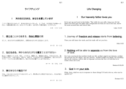
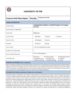
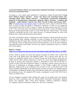
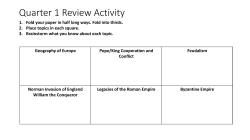
Francesca Carboni*, Frank Vermeulen*, Geert Verhoeven**, Patrick Monsieur*
*Ghent University, Department of Archaeology, **Ludwig Boltzmann Institute for Archaeological Prospection and Virtual Archaeology, Vienna
POTENTIA: INTEGRATED SURVEY AND MAPPING OF A ROMAN
COLONY ON THE ADRIATIC COAST
Potenza valley and surrounding
area with indication of main
Roman centres
Restitution of the coastal line and the river bed in
pre Roman and Roman age
The intensive archaeological field survey in and around the Roman
coastal colony Potentia is part of the geo-archaeological research
project `Potenza Valley Survey’, carried out since 2000 by a team of
the University of Ghent, in central Adriatic Italy (Marche region). Over
the years, this abandoned town, founded in 184 BC at the mouth of
the Flosis (Potenza) river, has been investigated through a large set
of intensive interdisciplinary operations, consisting of low altitude
aerial photography, systematic archaeological field walking, artefact
studies, re-study of excavated evidences, detailed geomorphological
field mapping, geophysical surveys and fine topographic mapping.
On this particular case study, quite spectacular are the results of
combined remote sensing work which led to a detailed plan depicting
the urban layout, with the gridded street networks perfectly defined
inside the rectangular defence circuit and the majority of public and
private buildings, as well as a large segment of the suburban
settlement system, comprising of three extramural funerary areas, the
roads connecting the city to the territorium and the original position of
the river bed.
These intrasite and peri-urban surveys have also been checked in
the field by a focused excavation carried out between 2007 and 2010
on the west gate of the Roman town. The excavations perfectly
confirm what is known from recent prospections of the general
topography and plan of the late Republican and Imperial city. They
also provide good chronological and stratigraphical evidence about
the two main building phases of the gate, the development of the
main East-West street and the character of the defences, with their
ditch, wall and agger.
Aerial photograph with the location of the city wall
and the decumanus maximus leading out of the
city.
Aerial photograph of the western sector of the city
with crop marks of the regular street network
Aerial photograph with the location of the
excavation of the western gate.
View of the excavated area, from East
View of the excavated area, from South.
Plan of the excavated area
General plan of the town of Potentia, with its
surrounding roads and cemeteries and the presumed
Roman mouth of the river Flosis
REFERENCES
Results of magnetic surveys
(Archaeological Prospection Services
Southampton)
Results of
microtopographic
survey on the site
of Potentia
Results of intra mural
artefact surveys.
F. VERMEULEN, 2012, Potentia: a Lost New Town, in: N. Christie & A. Augenti (eds.), Urbes
Extinctae. Archaeologies of Abandoned Classical Towns, Farnham, Ashgate, pp. 77-95.
F. VERMEULEN, M. DESTRO, P. MONSIEUR, F. CARBONI, S. DRALANS, D. VAN LIMBERGEN,
2011, Scavi presso la porta occidentale di Potentia: notizia preliminare, Picus. Studi e Ricerche sulle
Marche nell’Antichità, 31, pp.177-212.
F. VERMEULEN, 2011, Reviewing 10 years of aerial photography in the valley of the river Potenza
(Marche), in: G. Ceraudo (ed.), Archeologia Aerea, Proceedings of the International Congress
(Rome 2009). Foggia, pp. 255-266.
C. CORSI, M. DE DAPPER & F. VERMEULEN, 2009, River bed changing in the lower Potenza
Valley (mid-Adriatic Italy). A geo-archaeological approach to historical documents, Zeitschift für
Geomorphologie 53, suppl. 1, pp. 83-98.
F. VERMEULEN, S. HAY, G. VEHOEVEN, 2006, Potentia: an Integrated Survey of a Roman Colony
on the Adriatic Coast, Papers of the British School at Rome 74, pp. 203-236.
E. PERCOSSI, G. PIGNOCCHI & F. VERMEULEN (eds.), 2006, I siti archeologici della Vallata del
Potenza, Ancona
F. VERMEULEN, G. VERHOEVEN & J. SEMEY, 2005, The Integration of Aerial Photography and
GIS in the Potenza Valley Survey. In: Bourgeois, J. & Meganck, M. (eds.), Aerial Photography and
Archaeology 2003. A Century of Information, Gent, 371-382. (= Archaeological Reports Ghent
University 4).
Non-destructive approaches to complex archaeological sites in Europe: a round up
RADIO-PAST COLLOQUIUM January 15-17 2013 Ghent, Belgium
© Copyright 2026 Paperzz