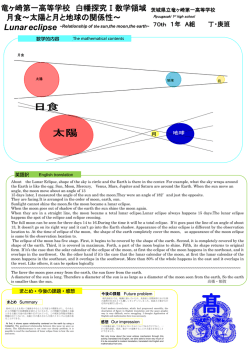
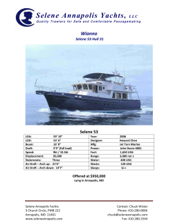
Findings from
Japan's Lunar Explorer "KAGUYA"
UNCOPUOS, Legal Subcommittee, 48th Session,
Vienna, 23 March – 3 April, 2009
JAXA/Japan
0
Why did we name Japan’s lunar explorer
“KAGUYA” ?
Among all the varied suggested nicknames, about 24 percent suggested names related to
“Princess Kaguya” from the old classic Japanese story “Taketori Monogatari (or the story
of a bamboo cutter and the princess from the Moon.)” From among these names,
“KAGUYA” accounted for almost 70 percent. It appears that SELENE, which travels to
the Moon, reminds many people of “Princess Kaguya,” who returned to the Moon.
KAGUYA Characteristics
Main Orbiter
Weight
KAGUYA
3
at launch
including sub-satellites50kg 2
Dimension
2.1m 2.1m 4.8
Mission Period
Year
Orbit
100km Altitude Inclination 90deg.
Global survey for the lunar origin
and evolution study
Data Application to Future Moon
Utilization
Technology development for the
lunar exploration
Public Outreach
Sub-satellites
Rstar(Relay satellite):OKINA
Vstar(VLBI Radio satellite):OUNA
Weight
50kg
Dimension
0.99m 0.99m 0.65m
Octagonal column shape
Mission Period
Year
Orbit at Separation
(Rstar OKINA) 100km 2400km
(Vstar: OUNA)
100km
800km
Mission
(1) Chemical elements distribution: XRS, GRS
(2) Mineralogical distribution: SP, MI
(3)Surface structure: TC, LALT, LRS
(4) Surface & Space environment: LMAG, PACE,
CPS, RS, UPI
(5) Gravitational field distribution: VRAD, RSAT
(6) Public outreach: HDTV
X-ray Spectrometer (XRS) Gamma-ray Spectrometer (GRS) Spectral Profiler (SP) Multi-band Imager (MI)
Terrain Camera (TC) Lunar Radar Sounder (LRS) Laser Altimeter (LALT) Lunar Magnetometer (LMAG)
Upper-atmosphere and Plasma Imager (UPI) Charged Particle Spectrometer (CPS)
Plasma energy Angle and Composition Experiment (PACE), Radio Science (RS), VLBI Radio-source
(VRAD), Relay Sat. transponder (RSAT), High Definition Television ca (HDTV)
2
New scientific knowledge of the Moon derived by
1) Lunar Radar Sounder Observations of Subsurface Layers
KAGUYA
under the Nearside Maria of the Moon
2) Farside Gravity Field of the Moon from Four-way Doppler
Measurements of SELENE (Kaguya)
3) Lunar Global Shape and Polar Topography Derived from
Kaguya-LALT Laser Altimetry
4) Long-lived Volcanism on the Lunar Farside Revealed by
SELENE Terrain Camera
-> Fill with missing half -Lunar Farside and sub-surface by
KAGUYA (limited information by legacy exploration)
Mare Moscoviense by Terrain Camera
Science Magazine Cover Page
February 13th issue by AAAS
North pole
Earth Diamond ring (eclipse)
Full Earth rise over North pole
©JAXA/NHK
High Definition TV camera (HDTV)
3
New most precious lunar surface map
- Laser Altimeter (LALT) -
Farside Gravity Field of the Moon
Farside
©JAXA/SELENE
Legacy Model by NASA
Black : Highest / White : Lowest point
Dirichlet-Jackson (–158.64 E, 5.44 N, +10.75 km),
Antoniadi –172.58 E, 70.43 S, –9.06 km)
The continuous range data of the LALT will enable us for
the first time in the world to construct an accurate and
precise global topographic map of the Moon
The color of the figure shows
strength of the gravity field in
blue, green, yellow, and red, in
that order. Red indicates a
positive gravity anomaly related
to either a topographic high or
a dense material in the
subsurface. In contrast, blue
shows that a negative gravity
anomaly related to a
topographic low or less dense
material.
KAGUYA new gravity accurate
model
©JAXA/SELENE
Nearside
6
SELENE(KAGUYA) on Internet
Image Gallery : http://www.kaguya.jaxa.jp
YouTube: http://www.youtube.com/jaxaselene
7
Let’s flythrough Tycho Crater produced from
TC obseration data
©JAXA/SELENE
We can fly through lunar surface by using high spatial resolution (10meter) KAGUYA
Terrain Camera data
8
© Copyright 2026 Paperzz