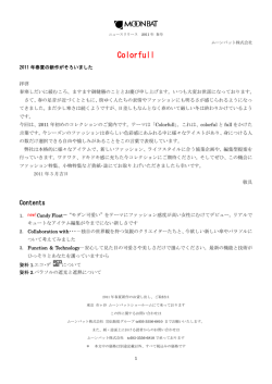
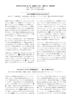
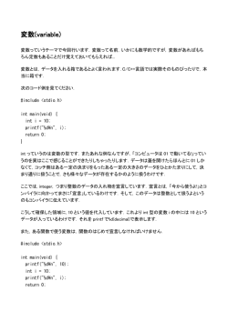
GPMデータ利用ハンドブック 付録-3 GPMプロダクトフォーマット 付録 3-1 DPR レベル 1 プロダクトフォーマット説明書 DPRレベル1プロダクトフォーマット説明書 目次 目 次 1. 概要 ........................................................................................................................... 1-1 1.1. 目的 ..................................................................................................................... 1-2 1.2. 関連文書............................................................................................................... 1-2 1.3. レベル定義 ............................................................................................................ 1-3 1.4. シーン定義 ............................................................................................................ 1-5 1.5. プロダクト構成 ........................................................................................................ 1-6 1.6. ファイルの分割とデータサイズ ................................................................................... 1-6 1.7. HDFデータ構造 ...................................................................................................... 1-7 1.7.1. Kuのファイル構造 .............................................................................................. 1-7 1.7.2. Kaのファイル構造 .............................................................................................. 1-8 1.8. ファイル名規約 ....................................................................................................... 1-8 1.8.1. 標準プロダクト .................................................................................................. 1-9 1.8.2. 準リアルタイムプロダクト .................................................................................... 1-12 2. レベル1プロダクト フォーマット仕様 .................................................................................. 2-1 2.1. 処理概要............................................................................................................... 2-2 2.1.1. 標準処理 ........................................................................................................ 2-2 2.1.2. 準リアルタイム処理 ............................................................................................ 2-2 2.2. ファイル入出力関連 ................................................................................................ 2-2 2.3. データ概要 ............................................................................................................ 2-4 2.3.1. 位置情報 ........................................................................................................ 2-6 2.3.2. 時刻定義 ........................................................................................................ 2-7 2.3.3. AngleBin時刻算出方法...................................................................................... 2-10 2.3.4. 欠損値 ........................................................................................................... 2-10 2.4. 標準プロダクトフォーマット ....................................................................................... 2-15 2.4.1. KuPRレベル1プロダクト ...................................................................................... 2-15 2.4.2. KaPRレベル1プロダクト ...................................................................................... 2-15 2.5. 準リアルタイムプロダクト .......................................................................................... 2-15 i DPRレベル1プロダクトフォーマット説明書 1 概要 1. 概 要 1-1 DPRレベル1プロダクトフォーマット説明書 1 概要 1.1. 目的 本文書は、GPM/DPRミッション運用系システムの処理固有部DPRレベル1B処理によって作成さ れるレベル1プロダクトについて記述したものである。 DPRレベル1B処理は、レベル1Aプロダクトを入力し、ラジオメトリック補正、幾何計算を施し、 KuPRレーダ、KaPRレーダごとに以下のプロダクトを作成する。 ・KuPRレベル1プロダクト ・KaPRレベル1プロダクト DPRレベル1プロダクトの記述フォーマットはHDF5(Hierarchical Data Format、バージョン5)とす る。本プロダクトはHDF5のライブラリ1.8を使用して作成している。 1.2. 関連文書 関連文書を以下に示す。 (1) 「HDF5 Reference Manual(Release 1.8.5)」 (TBD) (2) 「HDF5 User’s Guide (Release 1.8.5)」 (TBD) (3) 「全球降水観測計画(GPM)アルゴリズム開発計画書(案)」 (NDX-080013) (4) 「DPRレベル1Bアルゴリズム説明書」 (TBD) (5) 「GPMGeolocationToolkitATBD v2.1」 (TBD) (6)「GPMデータ利用ハンドブック」 (MAS-140012) 1-2 DPRレベル1プロダクトフォーマット説明書 1 概要 1.3. レベル定義 プロダクトレベルの定義を表1.3-1に示す。 表1.3-1 プロダクトレベル定義 名称 定義 運用モード 主な付加情報 KuPRレベル1 受信電力に対し、 ラジオ メトリック補 正、欠損情報に基 づく欠損処理、ス キャン時刻の補 正 、各 スキ ャン の 各レンジビンでの 時刻、緯度、経 度、高度情報等の 幾何計算を行った もの。 通常観測モード 外部校正モード SSPA動作解析モード LNA動作解析モード ・受信電力プロファイル ・スキャン、レンジビン の位置情報 ・品質情報 ・校正データ ・サイエンステレメトリの 受信カウント値 ・スキャン、レンジビン の位置情報 ・校正データ 欠損情報 KaPRレベル1 内部校正モード スタンバイモード ヘルスチェックモード プロダクトの運用モードは、以下の項目(表1.3-2)を参照することで識別できる。 表 1.3-2 運用モード格納項目 グループ名 項目名 scanStatus operationalMode 各運用モードについて、以下に概略を記述する。 表 1.3-3 運用モード概要 No. 運用モード 1 2 通常観測モード 外部校正モード 3 内部校正モード 4 SSPA動作解析モード 5 LNA動作解析モード 6 ヘルスチェックモード 概要 通常の観測モード 地上に設置したレーダ校正装置による 降雨レーダの構成を行うモード FCIFのRF信号折り返しループを用いて 受信系の校正を行うモード SSPAのそれぞれの素子が正常に信号 を増幅していることを確認するモード LNAのそれぞれの素子が正常に信号を 増幅していることを確認するモード SCDP内部のヘルスチェックを行うモー ド 1-3 DPRレベル1プロダクトフォーマット説明書 1 概要 No. 7 運用モード 概要 スタンバイモード 以下のいずれかをサイエンステレメトリ に出力するモード 可変PRFテーブルダンプ 位相コードダンプ メモリダンプ 各運用モードの詳細については、地球観測データ利用ハンドブック –GPM編-を参照のこと。 また、それぞれのスキャンのステータスは以下の項目にフラグとして格納される。 表 1.3-4 フラグ情報格納項目 No. グループ名 項目名 概要 1 scanStatus dataQuality L2で欠損とすべきスキャンに立つフラグ 2 dataWarning 3 missing 4 geoError 5 geoWarning 6 limitErrorFlag 7 SCorientation 8 modeStatus 固定PRFなど、注意が必要なスキャンに 立つ警告フラグ L1Bで欠損として処理したスキャンに立 つフラグ GeoTKでエラーになったスキャンに立つ フラグ GeoTKでWarningになったスキャンに立 つフラグ noisePower が閾値を超えたスキャンに 立つフラグ 視線ベクトルに異常がある場合に立つフ ラグ missing以外のエラーフラグの集約フラグ 9 pointingStatus GPSに異常があった場合に立つフラグ 観測について、1スキャンでのAngleBinは0-51の52個となるが、実際に電波を出して観測するの は、Angle Bin 1-49の49個である。残りのAngle Bin 0, 50, 51 は「dead Time」に相当し、Angle Bin 50, 51, (次スキャンの)0 が、連続した電波停止時間となる。なお、AngleBinの間隔は0.7sec刻みで ある。以下に通常観測時における観測概念図を示す。KaPRの観測幅は約120km、KuPRの観測幅 は約245kmである。 1-4 DPRレベル1プロダクトフォーマット説明書 1 概要 図1.3-1 通常観測時におけるKuPR、KaPR の観測概念図 1.4. シーン定義 地球の南端を起点に1周回のデータを1シーンとして定義する。シーン定義のイメージについて 「図1.4-1」に示す。 シーン終点 シーン始点 1-5 DPRレベル1プロダクトフォーマット説明書 1 概要 ・・・ 1スキャン シーン ・・・ 1シーンのスキャン数 約7900 1スキャン内訳 アングルビンの並び 1アングルビン内訳 衛星側 24 1 … … … … 1 1レンジビン 1スキャンのアングルビン数 NS:49 MS:25 HS:24 1 地球側 図1.4-1 シーン定義のイメージ 1.5. プロダクト構成 1シーン分のサイエンスデータを格納した1ファイルを、1プロダクトとする。 1.6. ファイルの分割とデータサイズ 1シーンをプロダクトの単位とする。 レベル1プロダクトのデータサイズを「表 1.6-1 プロダクトサイズ」に示す。 表 1.6-1 プロダクトサイズ No. 1 2 名称 KuPRレベル1 KuPRレベル1R KaPRレベル1 KaPRレベル1R 25 フットプリント 直径5km 49 1アングルビンの レンジビン数 NS:260 MS:260 HS:130 1アングルビン … データサイズ 約85[MByte/1周回] 約27[MByte] 約62[MByte/1周回] 約20[MByte] 1-6 DPRレベル1プロダクトフォーマット説明書 1 概要 1.7. HDFデータ構造 1.7.1. Kuのファイル構造 Kuのファイル構造を以下の図に示す。 FileHeader InputRecord NavigationRecord L1Aプロダクト情報 Geolocation toolkit(外部ツール)のインプットファイル名など FileInfo TKIOのフォーマット情報など JaxaInfo TotalQualityCodeの情報など DPRKuInfo Ku File アルゴリズム名やバージョン、開始、終了時間など 校正係数テーブルのバージョン情報など SwathHeader ScanTime Metadata(Attribute) スキャン時刻情報 Latitude Longitude NS Receiver 受信電力など Transmitter 送信電力など VertLocate 地表面に関する情報など scanStatus フラグ情報や運用モードなど navigation 衛星の位置情報など rayPointing HouseKeeping ビーム視線ベクトルなど HKデータなど Calibration 内部校正や解析モード時の情報 図1.7-1 Kuのファイル構造 ※ L1Aプロダクトとはレベル1プロダクトの前処理として実行されるプロセスの出力であり、レベル1 プロダクトのインプットとして用いられる。 ※ Geolocation toolkit とは、緯度経度情報などの算出に用いられる外部ツールである。 ※ TKIOとはプロダクト入出力のための外部ツールである 1-7 DPRレベル1プロダクトフォーマット説明書 1 概要 1.7.2. Kaのファイル構造 また、Kaのファイル構造を以下の図に示す。 FileHeader アルゴリズム名やバージョン、開始、終了時間など InputRecord L1Aプロダクト情報 NavigationRecord Geolocation toolkit(外部ツール)のインプットファイル名など FileInfo TKIOのフォーマット情報など JaxaInfo TotalQualityCodeの情報など DPRKaInfo Ka File 校正係数テーブルのバージョン情報など SwathHeader ScanTime Metadata(Attribute) スキャン時刻情報 Latitude Longitude HS Receiver 受信電力など Transmitter 送信電力など VertLocate 地表面に関する情報など scanStatus フラグ情報や運用モードなど navigation rayPointing HouseKeeping Calibration MS 衛星の位置情報など ビーム視線ベクトルなど HKデータなど 内部校正や解析モード時の情報 構造はHSと同じであるため、省略 図1.7-2 Kaのファイル構造 1.8. ファイル名規約 レベル1プロダクトのファイル名規約について「標準プロダクト」と「準リアルタイムプロダクト」に分 けて以下に示す。 1-8 DPRレベル1プロダクトフォーマット説明書 1 概要 1.8.1. 標準プロダクト グラニュールIDをファイル名とする。グラニュールIDとは、全球地球観測衛星データを一意に識 別することのできるコードのことを称する。 KuPRレベル1プロダクトのファイル名規約を「図 1.8-1 標準プロダクト KuPRレベル1ファイル 名」に示す。KaPRレベル1プロダクトのファイル名規約を「図 1.8-2 標準プロダクト KaPRレベル1 ファイル名」に示す。 図中の各項目の説明を「表1.8-1 標準プロダクト DPRレベル1 ファイル名の規約」に示す。 1-9 DPRレベル1プロダクトフォーマット説明書 1 概要 1 2 3 4 5 6 G P M C O R _ K U R _ Y Y M M D D h h m m _ h h m m _ n n n n n ① 7 8 9 10 11 12 13 14 15 16 17 18 19 20 21 22 23 24 25 26 27 28 29 30 31 32 33 34 35 36 37 38 39 40 41 42 43 44 45 46 47 48 ② ③ ④ ⑤ ⑥ ⑦ n _ 1 B S _ ⑧ ⑨ ⑩ ⑪ x x x ⑫ ⑬ _ v v v ⑭ ⑮ . h 5 ⑯ 図 1.8-1 標準プロダクト KuPRレベル1ファイル名 1 2 3 4 5 6 G P M C O R _ K A R _ Y Y M M D D h h m m _ h h m m _ n n n n n ① 7 8 9 10 11 12 13 14 15 16 17 18 19 20 21 22 23 24 25 26 27 28 29 30 31 32 33 34 35 36 37 38 39 40 41 42 43 44 45 46 47 48 ② ③ ④ ⑤ ⑥ ⑦ 図 1.8-2 n _ 1 B S _ ⑧ ⑨ ⑩ ⑪ 標準プロダクト KaPRレベル1ファイル名 表1.8-1 標準プロダクト DPRレベル1 ファイル名の規約 No. 種別 名称 文字数 ① ミッションID(ミッション 名+衛星識別) 6 GPMCOR【固定】 ② セパレータ 1 「_」(アンダースコア)【固定】 ③ セ ン サ ID ( セ ン サ 識 別) 3 XXX: シーンID 値 KUR:KuPR KAR:KaPR ④ セパレータ 1 「_」(アンダースコア)【固定】 ⑤ シーン開始時刻 10 UTC時刻 1-10 x ⑫ ⑬ x x _ v ⑭ ⑮ v v . ⑯ h 5 DPRレベル1プロダクトフォーマット説明書 1 概要 No. 種別 名称 文字数 値 YY:西暦 MM:月 DD:月ごとの日 hh:時刻 0~23 mm:分 0~59 ⑥ セパレータ 1 「_」(アンダースコア)【固定】 ⑦ シーン終了時刻 4 UTC時刻 hh:時刻 0~23 mm:分 0~59 ⑧ セパレータ 1 「_」(アンダースコア)【固定】 ⑨ オービット番号 6 000001~999999(ゼロ詰め6桁) ⑩ セパレータ 1 「_」(アンダースコア)【固定】 処理レベル 3 1BS【固定】 ⑫ セパレータ 1 「_」(アンダースコア)【固定】 ⑬ アルゴリズムID 3 アルゴリズム種別と開発チームを特定 ⑪ プロダクトID (処理アルゴリズム) ⑭ セパレータ 1 「_」(アンダースコア)【固定】 ⑮ プロダクトバージョン 3 XX+A: XX: 自然数 01~99 A: 英文字 A~Z 再処理はバージョン番号の数字 2 桁のみで識別する。 3 桁目の英文字はマイナーなバージョン変更を意味する。 アルゴリズムバージョンとソフトウェアバージョンはメタで管理 ⑯ ファイル拡張子 3 「.h5」【固定】 HDF5形式 1-11 DPRレベル1プロダクトフォーマット説明書 1 概要 1.8.2. 準リアルタイムプロダクト グラニュールIDをファイル名とする。 KuPRレベル1プロダクトのファイル名規約を「図 1.8-3 準リアルタイムプロダクト KuPRレベル1 ファイル名」に示す。KaPRレベル1プロダクトのファイル名規約を「図 1.8-4 準リアルタイムプロダク ト KaPRレベル1ファイル名」に示す。 図中の項目の説明を「表1.8-2 準リアルタイムプロダクト DPRレベル1Bファイル名の規約」に示 す。 1-12 DPRレベル1プロダクトフォーマット説明書 1 概要 1 2 3 4 5 6 G P M C O R _ K U R _ Y Y M M D D h h m m _ h h m m _ n n n n n ① 7 8 9 10 11 12 13 14 15 16 17 18 19 20 21 22 23 24 25 26 27 28 29 30 31 32 33 34 35 36 37 38 39 40 41 42 43 44 45 46 47 48 ② ③ ④ ⑤ ⑥ ⑦ ⑧ ⑨ n _ 1 B N _ ⑩ ⑪ x x x ⑫ ⑬ _ v v v ⑭ ⑮ . h 5 ⑯ 図 1.8-3 準リアルタイムプロダクト KuPRレベル1ファイル名 1 2 3 4 5 6 G P M C O R _ K A R _ Y Y M M D D h h m m _ h h m m _ n n n n n ① 7 8 9 10 11 12 13 14 15 16 17 18 19 20 21 22 23 24 25 26 27 28 29 30 31 32 33 34 35 36 37 38 39 40 41 42 43 44 45 46 47 48 ② ③ ④ ⑤ ⑥ ⑦ ⑧ ⑨ n _ 1 B N _ ⑩ ⑪ 図 1.8-4 準リアルタイムプロダクト KaPRレベル1ファイル名 表1.8-2 準リアルタイムプロダクト DPRレベル1Bファイル名の規約 No. 種別 名称 文字数 ① ミッションID(ミッション 名+衛星識別) 6 GPMCOR【固定】 ② セパレータ 1 「_」(アンダースコア)【固定】 ③ セ ン サ ID ( セ ン サ 識 別) 3 XXX: シーンID 値 KUR:KuPR KAR:KaPR ④ セパレータ 1 「_」(アンダースコア)【固定】 ⑤ シーン開始時刻 10 UTC時刻 1-13 x ⑫ ⑬ x x _ v ⑭ ⑮ v v . ⑯ h 5 DPRレベル1プロダクトフォーマット説明書 1 概要 No. 種別 名称 文字数 値 YY:西暦 MM:月 DD:月ごとの日 hh:時刻 0~23 mm:分 0~59 ⑥ セパレータ 1 「_」(アンダースコア)【固定】 ⑦ シーン終了時刻 4 UTC時刻 hh:時刻 0~23 mm:分 0~59 ⑧ セパレータ 1 「_」(アンダースコア)【固定】 ⑨ オービット番号 6 000001~999999(ゼロ詰め6桁) ⑩ セパレータ 1 「_」(アンダースコア)【固定】 処理レベル 3 1BR【固定】 ⑫ セパレータ 1 「_」(アンダースコア)【固定】 ⑬ アルゴリズムID 3 アルゴリズム種別と開発チームを特定 ⑪ プロダクトID (処理アルゴリズム) ⑭ セパレータ 1 「_」(アンダースコア)【固定】 ⑮ プロダクトバージョン 3 XX+A: XX: 自然数 01~99 A: 英文字 A~Z 再処理はバージョン番号の数字 2 桁のみで識別する。 3 桁目の英文字はマイナーなバージョン変更を意味する。 アルゴリズムバージョンとソフトウェアバージョンはメタで管理 ⑯ ファイル拡張子 3 「.h5」【固定】 HDF5形式 1-14 DPRレベル1プロダクトフォーマット説明書 2 レベル1プロダクト フォーマット仕様 2. レベル1プロダクト フォーマット仕様 2-1 DPRレベル1プロダクトフォーマット説明書 2 レベル1プロダクト フォーマット仕様 2.1. 処理概要 レベル1B処理の概要について以下に示す。 2.1.1. 標準処理 DPRレベル1B標準処理では、入力となるレベル1Aプロダクトを読み込み、受信電力プロ ファイル、観測位置等の幾何情報を含んだプロダクトを出力する。処理内容は、ラジオメトリ ック補正、欠損情報に基づく欠損処理、スキャン時刻の補正、各スキャンの各レンジビンで の時刻、緯度、経度、高度情報等の幾何計算を行う。 上記の処理をKuPRレーダ、KaPRレーダの入力値に対し行う。処理フローを図2.1-1に示 す。 レベル1Aプロダクト入力 欠損処理 スキャン時刻補正 幾何計算 ラジオメトリック補正 レベル1プロダクト出力 図2.1-1 レベル1B標準処理フロー 2.1.2. 準リアルタイム処理 準リアルタイム処理の概要は、「2.1.1 標準処理」 と同様である。 2.2. ファイル入出力関連 レベル1B処理のファイル入出力について表2.2-1に示す。 2-2 DPRレベル1プロダクトフォーマット説明書 2 レベル1プロダクト フォーマット仕様 表2.2-1 DPRレベル1B処理での入出力ファイル一覧 No 1 2 入/出 入 入 ファイル名 レベル1AKuPRプロダクト レベル1AKaPRプロダクト 3 入 L1Bデータベース 4 入 geolocation toolkit入力ファイ ル 5 入 制御情報ファイル 主な格納項目 ・スキャン数 ・サイエンステレメトリ ・HKテレメトリ ・スキャン数 ・サイエンステレメトリ ・HKテレメトリ ・VPRFテーブル ・校正係数 ・走査角度 ・基本システム情報テーブル ・offset DB テーブル ・軌道、姿勢関連情報 ・シーンの開始・終了時刻 ・ファイルパス ・HKテレメントリ ・スキャン数 ・スキャン時刻、各スキャンの地理情 5 出 レベル1BKuPRプロダクト 報 ・各スキャンの鉛直情報 ・KuPRセンサでの各周波数でのレ ーダ受信電力値 ・校正係数 ・HKテレメントリ ・スキャン数 ・スキャン時刻、各スキャンの地理情 報 6 出 レベル1BKaPRプロダクト ・各スキャンの鉛直情報 ・KaPRセンサでの各周波数でのレー ダ受信電力値 ・校正係数 ・ プ ロ ダ ク ト の 状 態 ( Good 、 NG 、 7 出 処理結果 Poor、EG) ・G-Portalへの情報 8 出 ブラウズ 受信電力の地図へのマッピング画像 9 出 サムネイル ブラウズのサムネイル ※ 標準プロダクトと準リアルタイムプロダクトの内容は同一である。 2-3 フォーマット HDF5 HDF5 ASCII ま た はバイナリ XML HDF5 HDF5 XML JPEG JPEG DPRレベル1プロダクトフォーマット説明書 2 レベル1プロダクト フォーマット仕様 2.3. データ概要 データの内容を表2.3-1に示す。 2-4 DPRレベル1プロダクトフォーマット説明書 2 レベル1プロダクト フォーマット仕様 表2.3-1 DPRレベル1プロダクトの内容 処理レベル プロダクト KuPRレベル1 プロダクト シーン単位 1周回 観測領域 約245km ピクセルサイズ 水平約5km 鉛直125m レベル1B KaPRレベル1 プロダクト 1周回 約125km 水平約5km 鉛直125m/250m 観測モード 通常観測モード 外部校正モード SSPA動作解析モード LAN動作解析モード 内部校正モード スタンバイモード ヘルスチェックモード 通常観測モード 外部校正モード SSPA動作解析モード LAN動作解析モード 内部校正モード スタンバイモード ヘルスチェックモード ※ 標準プロダクトと準リアルタイムプロダクトの内容は同一である。 2-5 備考 - 受信電力値にサイエンステレメトリの受信カ ウント値を入力。100倍スケーリングを行わな い 欠損情報を格納 - 受信電力値にサイエンステレメトリの受信カ ウント値を入力。100倍スケーリングを行わな い 欠損情報を格納 DPRレベル1プロダクトフォーマット説明書 2 レベル1プロダクト フォーマット仕様 2.3.1. 位置情報 プロダクトに格納される 位置情報を表2.3-2に示す。 緯度経度などの位置情報は外部ツール( Geolocation toolkit)により算出される。 表2.3-2 プロダクトに格納される位置情報 No. グループ名 項目名 単位 概要 1 - Latitude degrees 2 - Longitude degrees 3 navigation greenHourAng m 4 scAlt m 5 scAttPitchGeoc degrees 6 scAttPitchGeod degrees 7 scAttRollGeoc degrees 8 scAttRollGeod degrees 9 scAttYawGeoc degrees 10 scAttYawGeod degrees 11 scLat degrees 12 scLon degrees 13 scPos m 各アングルビ ンでの緯度 各アングルビ ンでの経度 Greenwich Hour angle at scan mid 衛星直下の 高度 S/C geocentric pitch at scan mid time S/C geodetic pitch at scan mid time S/C geocentric roll at scan mid time S/C geodetic roll at scan mid time S/C geocentric Yaw at scan mid time S/C geodetic yaw at scan mid time 衛星直下の 緯度 衛星直下の 経度 地球固定座 標系での衛 星の位置 2-6 DPRレベル1プロダクトフォーマット説明書 2 レベル1プロダクト フォーマット仕様 No. グループ名 項目名 単位 概要 scVel m/s instrumentPitch degrees 16 instrumentRoll degrees 17 instrumentYaw degrees scLocalZenith degrees scRangeEllipsoid m 地球固定座 標系での衛 星の速度 Instrument pitch/pixel time (deg) Instrument roll/pixel time (deg) Instrument yaw/pixel time (deg) レンジビンで の天頂角 エリプソイド までの距離 14 15 18 rayPointing VertLocate 19 回転楕円体としてWGS-84 を使用している。項目の詳細については、GPMGeolocationToolkitATBDv2.1 を参照のこと。 また、位置情報算出時にGeolocation toolkit に与えている視線ベクトルは以下の項目に格納されてい る。 表2.3-3 視線ベクトル格納項目 No. グループ名 項目名 単位 概要 1 rayPointing rayDirectionX - rayDirectionY - DPR機械座 標系におけ るビーム指 向方向X DPR機械座 標系におけ るビーム指 向方向Y 2 ビーム視線ベクトルはDPR機械座標系におけるビーム指向方向の単位ベクトルである。算出方法につい てはDPRレベル1Bアルゴリズム説明書を参照のこと。 2.3.2. 時刻定義 格納される時刻はスキャンの中心時刻、すなわちKuではAngleBin#25 の開始時刻、MSでは AngleBin #13の開始時刻、HSでは AngleBin#37 の中心時刻となる。サイエンステレトリのSecondary Header には 2-7 DPRレベル1プロダクトフォーマット説明書 2 レベル1プロダクト フォーマット仕様 Kuの Anglebin#0 の開始時刻が格納されるため、Kaは固定遅延時間を考慮して時刻の算出を行う。 Ku、Kaともに遅延がない場合の時刻を以下の図に示す。 図2.3-1 遅延がない場合の時刻情報 この場合、NSの格納時刻とMSの格納時刻は一致する。 Kaにのみ遅延がある場合の時刻を以下の図に示す。 図2.3-2 Kaにのみ遅延がある場合の時刻情報 遅延時間は衛星進行方向のビームミスマッチ補正を行うために設定され、この場合NSとMSの時 刻は一致しない。ビームミスマッチとは、KuPRまたはKaPRにおいて、送信ビームと受信ビームの方 向が一致しないことである。 Kuにのみ遅延がある場合の時刻を以下の図に示す。 2-8 DPRレベル1プロダクトフォーマット説明書 2 レベル1プロダクト フォーマット仕様 図2.3-3 Kuにのみ遅延がある場合の時刻情報 遅延時間は衛星進行方向のビームミスマッチ補正を行うために設定され、この場合NSとMSの時刻は一致 しない。 SCDP独立運用の場合の時刻を以下の図に示す。 図2.3-4 SCDP独立運用場合の時刻情報 SCDP独立運用とは、KuPRとKaPRのシステム制御・データ処理を独立させて運用することである。この場 合、Kaの固定遅延時間は設定されず、Secondary Header にはそれぞれのセンサのAngleBin#0 の開始 時刻が格納される。 2-9 DPRレベル1プロダクトフォーマット説明書 2 レベル1プロダクト フォーマット仕様 2.3.3. AngleBin時刻算出方法 それぞれのAngleBinの時刻を算出する場合、以下の項目を使用する。 表2.3-4 AngleBin 時刻算出で使用する項目 No. グループ名 項目名 説明 1 HouseKeeping scTime 2 rayPointing rayTiming Secondary Header の格納時 刻。1980年1月6日00:00:00か らの積算秒で格納 Secondary Header の格納時 刻を基準としたAngle Bin[n]に おけるオフセット時間 rayTiming にはSecondary Header の格納時刻から、各AngleBinの中心時刻までのオフセット時刻が格 納されている。scTime に rayPointing を足し合わせることでAngleBin の時刻を求めることができる。な お、rayTiming に格納されている中心時刻は、Angle Bin [n]の時刻とAngle Bin [n+1]の時刻の平均であ る。 2.3.4. 欠損値 通常観測、外部校正、SSPA動作解析、LNA動作解析モードの場合、データが欠落したスキャンのみ、 以下の表に示す項目が欠損値となる。またスタンバイ、ダンプモードの場合、以下の表に示す項目が全 て欠損値となる。 表2.3-2 欠損値一覧 No. グループ名 項目名 欠損値 1 ScanTime Year N/A 2 Month N/A 3 DayOhMonth N/A 4 Hour N/A 5 Minute N/A 6 Second N/A 7 MilliSecond N/A 8 DayOfYear N/A 9 SecondOfDay N/A 10 - Latitude -9999.9 11 - Longitude -9999.9 12 Receiver noiseCount -9999.9 2-10 DPRレベル1プロダクトフォーマット説明書 2 レベル1プロダクト フォーマット仕様 No. グループ名 13 項目名 欠損値 echoPower -29999 -30000 14 noisePower -30000 15 noiseSampleNumber -9999 16 rxAntGain -9999.9 radarTransPower -9999.9 18 transPulseWidth -9999.9 19 txAntGain -9999.9 DEMHmean -9999 21 alongTrackBeamWidth N/A 22 binDEm -9999 23 binDEMHtop -9999 24 binDEMHbottom -9999 25 binEchoPeak -9999 26 binEllipsoid -9999 27 crossTrackBeamWidth N/A 28 echoHighResBinNumber -9999 29 echoLowResBinNumber -9999 30 landOceanFlag -9999 31 mainlobeEdge -9999 32 rangeBinSize -9999.9 33 scLocalZenith -9999.9 34 scRangeDEM -9999.9 35 scRangeEllipsoid -9999.9 36 sidelobeEdge -9999 37 startBinRange -9999.9 FractionalGranuleNumber N/A 39 SCorientation -9999 40 acsModeMidScan N/A 41 dataQuality N/A 42 dataWarning N/A 43 geoError N/A 44 geoWarning N/A 17 20 38 Transmitter VertLocate scanStatus 2-11 DPRレベル1プロダクトフォーマット説明書 2 レベル1プロダクト フォーマット仕様 項目名 欠損値 45 limitErrorFlag N/A 46 missing N/A 47 modeStatus N/A 48 operationalMode -99 49 pointingStatus -9999 50 targetSelectionMidScan -99 dprAlt -9999.9 52 greenHourAng -9999.9 53 scAttPitchGeoc -9999.9 54 scAttPitchGeod -9999.9 55 scAttRollGeoc -9999.9 56 scAttRollGeod -9999.9 57 scAttYawGeoc -9999.9 58 scAttYawGeod -9999.9 59 scLat -9999.9 60 scLon -9999.9 61 scPos -9999.9 62 scVel -9999.9 63 timeMidScan -9999.9 64 timeMidScanOffset -9999.9 instrumentPitch -9999.9 66 instrumentRoll -9999.9 67 instrumentYaw -9999.9 68 rayDirectionX N/A 69 rayDirectionY N/A 70 rayTiming N/A 71 scanAngle N/A binDiffPeakDEM -9999 73 cathingInt -99 74 delay -9999 75 divcomb1Temp -9999 76 divcomb2Temp -9999 77 fcifFlag N/A No. 51 65 72 グループ名 navigation rayPointing HouseKeeping 2-12 DPRレベル1プロダクトフォーマット説明書 2 レベル1プロダクト フォーマット仕様 項目名 欠損値 78 fcifTemp -9999 79 lnaTemp -9999 80 logAmpNoiseLevel -9999 81 rdaTemp -9999 82 rxAtt -99 83 rxAttGainOffset -9999.9 84 scTime N/A 85 scdpFlag N/A 86 seqCountL1A -9999 87 sspaTemp -9999 88 vprfTableSelect -99 89 vprfTableVersion -99 angleBinSelect -99 91 fcifInPower -30000 92 intAttSelect -99 93 sspaLnaSelect -99 No. 90 グループ名 Calibration 内部校正モードの場合、以下の表に示す項目が全て欠損値となる。 表2.3-3 内部校正モード時の欠損値一覧 No. グループ名 項目名 欠損値 1 Receiver noiseCount -9999.9 2 noisePower -30000 3 noiseSampleNumber -9999 4 rxAntGain -9999.9 radarTransPower -9999.9 6 transPulseWidth -9999.9 7 txAntGain -9999.9 startBinRange -9999.9 9 echoLowResBinNumber -9999 10 binEllipsoid -9999 11 binDEm -9999 12 binDEMHtop -9999 5 8 Transmitter VertLocate 2-13 DPRレベル1プロダクトフォーマット説明書 2 レベル1プロダクト フォーマット仕様 項目名 欠損値 13 binDEMHbottom -9999 14 binEchoPeak -9999 15 ellipsoidBinOffset -9999.9 16 rangeBinSize -9999.9 17 mainlobeEdge -9999 18 sidelobeEdge -9999 binDiffPeakDEM -9999 20 vprfTableVersion -99 21 vprfTableSelect -99 22 rxAttGainOffset -9999.9 23 catchingInt -99 No. 19 グループ名 HouseKeeping なお、データ欠損の場合のフラグ情報については表1-3.4を参照のこと 2-14 DPRレベル1プロダクトフォーマット説明書 2 レベル1プロダクト フォーマット仕様 2.4. 標準プロダクトフォーマット 2.4.1. KuPRレベル1プロダクト KuPR レベル 1 プロダクトのフォーマットを「表 2.5-1 KuPR レベル 1 プロダクト」に示す。 2.4.2. KaPRレベル1プロダクト KaPR レベル 1 プロダクトのフォーマットを「表 2.5-2 2.5. 準リアルタイムプロダクト 「2.3.標準プロダクト」と同様。 2-15 KaPR レベル 1 プロダクト」に示す。 DPRレベル1プロダクトフォーマット説明書(改訂版) 2 レベル1プロダクトフォーマット仕様 表 2.5-1 KuPR レベル 1 プロダクトフォーマット Group Name 1 Group Name 2 DPR Initial 1BKu Value Name Year[nscan] missing min max -9999 1950 Month[nscan] -99 DayOfMonth[nscan] unit 2100 [years] type array Data size type Remark signed 2B int 15800 2 nscan 1 1 1 12 [months] signed 1B int 7900 1 nscan 1 1 -99 1 31 [days] signed 1B int 7900 1 nscan 1 1 Hour[nscan] -99 0 23 [hours] signed 1B int 7900 1 nscan 1 1 Minute[nscan] -99 0 59 [minutes] signed 1B int 7900 1 nscan 1 1 -99 -9999 -9999 -9999.9 -9999.9 -9999.9 0 0 1 0 -90 -180 7900 15800 15800 63200 1548400 1548400 1 2 2 8 4 4 nscan nscan nscan nscan 49 49 1 1 1 1 nscan nscan 1 1 1 1 1 1 ScanTime (N/A) (N/A) Second[nscan] MilliSecond[nscan] DayOfYear[nscan] SecondOfDay[nscan] Latitude[nray][nscan] Longitude[nray][nscan] 60 999 366 86400 90 180 [s] [ms] [days] [s] [degrees] [degrees] signed 1B int signed 2B int signed 2B int 8B double 4B float 4B float dataQuality[nscan] signed 1B int 7900 1 nscan 1 A summary of data quality in the scan. Unless this is 0 (normal), the scan data is 564 5 STANDARD GPM PRODUCTS meaningless to higher precipitation processing. Bit 0 is the least significant bit (i.e., if bit i = 1 and other bits = 0, the unsigned integer value is 2**i). 1 Bit Meaning if bit = 1 0 missing 5 geoError is not zero 6 modeStatus is not zero dataWarning[nscan] signed 1B int 7900 1 nscan 1 1 Format edited by JAXA/EORC. 1 Indicates whether information is contained in the scan data. The values are: Bit Meaning if bit = 1 0 Scan is missing 1 Science telemetry packet missing 2 Science telemetry segment withing packet missing 1 3 Science telemetry other missing 4 Housekeeping (HK) telemetry packet missing 5 Spare (always 0) 6 Spare (always 0) 7 Spare (always 0) missing[nscan] signed 1B int 7900 1 nscan modeStatus[nscan] signed 1B int 7900 1 nscan 1 geoError[nscan] signed 2B int 15800 2 nscan 1 geoWarning[nscan] signed 2B int 15800 2 nscan pointingStatus[nscan] -9999 15800 -9999 signed 2B int acsModeMidScan[nscan] targetSelectionMidScan[nscan] signed 1B int -99 operationalMode[nscan] 1BKu NS signed 1B int 1 20 signed 1B int limitErrorFlag[nscan] navigation signed 1B int 100000 10000000 10000000 70 180 500000 500000 1 1 The positive angle of the spacecraft vector (v) from the satellite forward direction of motion, measured clockwise facing down. We define v in the same direction as the spacecraft axis +X, which is also the center of the GMI scan. If SCorientation is not 0 or 180, a bit is set to 1 in modeStatus. 1 Value Meaning 0 +X forward (yaw 0) 180 -X forward (yaw 180) -8000 Non-nominal pointing -9999 Missing 7900 7900 7900 2 1 1 1 nscan 1 pointingStatus is provided by the geo Toolkit. A value of zero means the pointing is good. Non-zero values indicate non-nominal pointing. If pointingStatus is non-zero, a bit in modeStatus is set to 1. Value Meaning 1 0 Nominal pointing in Mission Science Mode 1 GPS point solution stale and PVT ephemeris used 2 GEONS solution stale and GEONS ephemeris used -8000 Non-nominal mission science orientation -9999 Missing nscan 1 acsModeMidScan is provided by the geo Toolkit as taken from Attitude Control System telemetry and is provided in this format for information only. Value Meaning 0 LAUNCH 1 RATENULL 2 SUNPOINT 1 3 GSPM (Gyro-less Sun Point) 4 MSM (Mission Science Mode) 5 SLEW 6 DELTAH 7 DELTAV -99 UNKNOWN -- ACS mode unavailable nscan 1 targetSelectionMidScan is provided by the geo Toolkit as taken from Attitude Control System telemetry and is provided in this format for information only. Value Meaning 0 S/C Z axis nadir, +X in flight direction 1 Flight Z axis nadir, +X in flight direction 1 2 S/C Z axis nadir, -X in flight direction 3 Flight Z axis nadir, -X in flight direction 4 +90 yaw for DPR antenna pattern calibration 5 -90 yaw for DPR antenna pattern calibration -99 Missing nscan 1 The operational mode of KuPR/KaPR stored in science telemetry. operationalMode is used in modeStatus. The range is 1 to 20. Value Meaning 1 Ku/Ka Observation 2 Ku/Ka External Calibration 3 Ku/Ka Internal Calibration 4 Ku/Ka SSPA Analysis 5 Ku/Ka LNA Analysis 6 Ku/Ka Health-Check 7 Ku/Ka Standby VPRF Table OUT 8 Ku/Ka Standby Phase Out 1 9 Ku/Ka Standby Dump Out 10 Ku/Ka Standby (No Science Data) 11 Ku/Ka Independent Observation 12 Ku/Ka Independent External Calibration 13 Ku/Ka Independent Internal Calibration 14 Ku/Ka Independent SSPA Analysis 15 Ku/Ka Independent LNA Analysis 16 Ku/Ka Independent Health-Check 17 Ku/Ka Independent Standby VPRF Table OUT 18 Ku/Ka Independent Standby Phase Out 19 Ku/Ka Independent Standby Dump Out 20 Ku/Ka Independent Standby (No Science Data) nscan Bit flags for every ray with information about echo power limit checks. 1 limitErrorFlag may be used in modeStatus. Detailed information is defined in L1B Product Format edited by JAXA/EORC. 7900 1 nscan 1 63200 94800 94800 31600 31600 31600 31600 8 4 4 4 4 4 4 nscan 3 3 nscan nscan nscan nscan 1 nscan nscan 1 1 1 1 FractionalGranuleNumber[nscan] scPos[XYZ][nscan] scVel[XYZ][nscan] scLat[nscan] scLon[nscan] scAlt[nscan] dprAlt[nscan] -9999.9 -9999.9 -9999.9 -9999.9 -9999.9 -9999.9 -9999.9 0 -10000000 -10000000 -70 -180 350000 350000 scAttRollGeoc[nscan] -9999.9 -180 180 [degrees] 4B float 31600 4 nscan 1 1 scAttPitchGeoc[nscan] -9999.9 -180 180 [degrees] 4B float 31600 4 nscan 1 1 scAttYawGeoc[nscan] -9999.9 -135 225 [degrees] 4B float 31600 4 nscan 1 1 scAttRollGeod[nscan] -9999.9 -180 180 [degrees] 4B float 31600 4 nscan 1 1 scAttPitchGeod[nscan] -9999.9 -180 180 [degrees] 4B float 31600 4 nscan 1 1 scAttYawGeod[nscan] -9999.9 -135 225 [degrees] 4B float 31600 4 nscan 1 1 greenHourAng[nscan] -9999.9 0 390 [degrees] 4B float 31600 4 nscan 1 1 timeMidScan[nscan] timeMidScanOffset[nscan] -9999.9 -9999.9 0 0 63200 63200 8 8 nscan nscan 1 1 1 1 [m] [m/s] [degrees] [degrees] [m] [m] 10000000000 [s] 100 [s] 8B double 4B float 4B float 4B float 4B float 4B float 4B float 15800 2 A summary of status modes. If all status modes are routine, all bits in modeStatus = 0. Routine means that scan data has been measured in the normal operational situation as far as the status modes are concerned. modeStatus does not assess geolocation quality. modeStatus is broken into 8 bit flags. Each bit = 0 if the status is routine but the bit = 1 if the status is not routine. Bit 0 is the least significant bit (i.e., if bit i = 1 and other bits = 0, the unsigned integer value is 2**i). The non-routine situations follow: Bit Meaning if bit = 1 1 0 Spare (always 0) 1 SCorientation not 0 or 180 2 pointingStatus not 0 3 Non-routine limitErrorFlag 4 Non-routine operationalMode (not 1 or 11) 5 Spare (always 0) 6 Spare (always 0) 7 Spare (always 0) A summary of geolocation errors in the scan. geoError is used to set a bit in dataQuality. 5.18 1BKu - Ku Power 565 A zero integer value of geoError indicates ’good’ geolocation. A non-zero value broken down into the bit flags below indicates the specified reason, where bit 0 is the least significant bit (i.e., if bit i = 1 and other bits = 0 the unsigned integer value is 2**i). Bits 0, 4, 5, 8 and 9 are per pixel error flags. If the number of bad pixels (for any of the reasons specified by these flags) is greater than the threshold then bit 7 = 1 and each of these flags is set to 1 if any pixel is bad for that reason. At launch this threshold is zero, so data is flagged if any pixel is bad. If the number of bad pixels is less than or equal to the threshold then bit 7 = 0 and all of these flags are also 0. Bit Meaning if bit = 1 0 Latitude limit exceeded for viewed pixel locations 1 Negative scan time, invalid input 1 2 Error getting spacecraft attitude at scan mid-time 3 Error getting spacecraft ephemeris at scan mid-time 4 Invalid input non-unit ray vector for any pixel 5 Ray misses Earth for any pixel with normal pointing 6 Nadir calculation error for subsatellite position 7 Pixel count with geolocation error over threshold 8 Error in getting spacecraft attitude for any pixel 9 Error in getting spacecraft ephemeris for any pixel 10 Spare (always 0) 11 Spare (always 0) 12 Spare (always 0) 13 Spare (always 0) 14 Spare (always 0) 15 Spare (always 0) A summary of geolocation warnings in the scan. geoWarning does not set a bit in dataQuality. Warnings indicate unusual conditions. These conditions do not indicate bad geolocation but are flagged as a warning that further review of the data may be useful. A zero integer value indicates usual geolocation. A non-zero value broken down into the following bit flags indicates the following, where bit 0 is the least significant bit (i.e., if bit i = 1 and other bits = 0 the unsigned integer value is 2**i): Bit Meaning if bit = 1 0 Ephemeris Gap Interpolated * 1 Attitude Gap Interpolated * 2 Attitude jump/discontinuity * 3 Attitude out of range * 1 4 Anomalous Time Step * 5 GHA not calculated due to error 6 SunData (Group) not calculated due to error 7 Failure to calculate Sun in inertial coordinates 8 Fallback to GES ephemeris * 9 Fallback to GEONS ephemeris * 10 Fallback to PVT ephemeris * 11 Fallback to OBP ephemeris * 12 Spare (always 0) 13 Spare (always 0) 14 Spare (always 0) 15 Spare (always 0) scanStatus Scorientation[nscan] Flag of data warning for each scan. Detailed information is defined in L1B Product 8B double 8B double 2-16 1 The floating point granule number. The granule begins at the Southern-most point of 1 the spacecraft’s trajectory. For example, FractionalGranuleNumber = 10.5 means the 1 1 1 1 1 DPRレベル1プロダクトフォーマット説明書(改訂版) 2 レベル1プロダクトフォーマット仕様 Group Name 1 Group Name 2 rayPointing DPR Initial 1BKu Value Name missing min max rayDirectionX[nray][nscan] rayDirectionY[nray][nscan] -9999.9 -9999.9 -1 -1 instrumentYaw[nray][nscan] -9999.9 instrumentPitch[nray][nscan] unit array Data size type Remark 4B float 4B float 1548400 1548400 4 4 49 49 nscan nscan 1 1 -135 225 [degrees] 4B float 1548400 4 49 nscan 1 -9999.9 -90 90 [degrees] 4B float 1548400 4 49 nscan 1 instrumentRoll[nray][nscan] -9999.9 -180 180 [degrees] 4B float 1548400 4 49 nscan 1 rayTiming[nray][nscan] -9999.9 0 1.6 [s] 4B float 1548400 4 49 nscan 1 scanAngle[nray][nscan] -9999.9 -18 18 [degrees] 4B float 1548400 4 49 nscan 1 rxAtt[nscan] rxAttGainOffset[nscan] binDiffPeakDEM[nray][nscan] scTime[nscan] vprfTableVersion[nscan] -99 -9999.9 -9999 -9999.9 -99 0 -260 -260 7900 31600 774200 63200 7900 1 4 2 8 1 nscan nscan 49 nscan nscan 1 1 nscan 1 1 1 1 1 1 1 vprfTableSelect[nscan] 1 1 1 1 type 12 [dB] 260 [dB] 260 127 25 signed 1B int 4B float signed 2B int 8B float signed 1B int signed 1B int 7900 1 nscan 1 the selected number of VPRF table for altitude (h, km) which is used in L1B process. The range is 1 to 25. h LT 396.5 = 1 396.5 LE h LT 397.5 = 2 397.5 LE h LT 398.5 = 3 398.5 LE h LT 399.5 = 4 399.5 LE h LT 400.5 = 5 400.5 LE h LT 401.5 = 6 401.5 LE h LT 402.5 = 7 402.5 LE h LT 403.5 = 8 403.5 LE h LT 404.5 = 9 404.5 LE h LT 405.5 = 10 405.5 LE h LT 406.5 = 11 406.5 LE h LT 407.5 = 12 407.5 LE h LT 408.5 = 13 1 408.5 LE h LT 409.5 = 14 409.5 LE h LT 410.5 = 15 410.5 LE h LT 411.5 = 16 411.5 LE h LT 412.5 = 17 412.5 LE h LT 413.5 = 18 413.5 LE h LT 414.5 = 19 414.5 LE h LT 415.5 = 20 415.5 LE h LT 416.5 = 21 416.5 LE h LT 417.5 = 22 417.5 LE h LT 418.5 = 23 418.5 LE h LT 419.5 = 24 419.5 LE h = 25 where LT mean less than and LE means less than or equal to HouseKeeping catchingInt[nscan] -99 8 12 signed 1B int scdpFlag[nscan] signed 1B int fcifFlag[nscan] logAmpNoiseLevel[nscan] delay[nscan] seqCountL1A[nscan] fcifTemp[2xnscan] lnaTemp[2xnscan] rdaTemp[2xnscan] divcomb1Temp[2xnscan] divcomb2Temp[2xnscan] sspaTemp[2xnscan] landOceanFlag[nray][nscan] VertLocate Calibration Transmitter [dBm] 0 0 -5000 -5000 -5000 -5000 -5000 -5000 3360 27000 5000 5000 5000 5000 5000 5000 0 3 scLocalZenith[nray][nscan] -9999.9 0 startBinRange[nray][nscan] -9999.9 350000 [C] [C] [C] [C] [C] [C] (N/A) InputRecord (N/A) NavigationRecord (N/A) FileInfo (N/A) JAXAInfo (N/A) 1BKu-Metadata 1 1 The side of the SCDP system and system table used. Bit Meaning if bit=1 0 B-side is used (if bit=0, then A-side used) 1 Priority is 1 at Basic System Table. Refer to Basic System Table. 2 Priority is 2 at Basic System Table. Refer to HK telemetry. 1 3 Priority is 2 at Basic System Table. Refer to Basic System Table. 4 (Spare) 5 (Spare) 6 (Spare) 7 (Spare) 1 nscan 1 2B int 2B int 2B int 2B int 2B int 2B int 2B int 2B int 2B int 15800 15800 15800 31600 31600 31600 31600 31600 31600 2 2 2 2 2 2 2 2 2 nscan nscan nscan 2×nscan 2×nscan 2×nscan 2×nscan 2×nscan 2×nscan 1 1 1 1 1 1 1 1 1 1 1 1 1 1 1 1 1 1 signed 2B int 774200 2 49 nscan 1548400 4 49 nscan 1 1548400 4 49 nscan 1 signed signed signed signed signed signed signed signed signed 4B float The first dimension is temperature and the other is the The first dimension is temperature and the other is the The first dimension is temperature and the other is the The first dimension is temperature and the other is the The first dimension is temperature and the other is the The first dimension is temperature and the other is the Land or ocean information. The values of the flag are: 0 = Water 1 1 = Land 2 = Coast 3 = Inland Water number number number number number number of of of of of of referenced referenced referenced referenced referenced referenced HK HK HK HK HK HK echoHighResBinNumber[nray][nscan] -9999 1 260 signed 2B int 774200 2 49 nscan echoLowResBinNumber[nray][nscan] binEllipsoid[nray][nscan] scRangeEllipsoid[nray][nscan] binDEM[nray][nscan] scRangeDEM[nray][nscan] DEMHmean[nray][nscan] binDEMHtop[nray][nscan] binDEMHbottom[nray][nscan] binEchoPeak[nray][nscan] -9999 -9999 -9999.9 -9999 -9999.9 -9999 -9999 -9999 -9999 0 1 0 1 0 0 1 1 1 260 260 500000 [m] 260 500000 [m] 9000 [m] 260 260 260 signed 2B int signed 2B int 4B float signed 2B int 4B float signed 2B int signed 2B int signed 2B int signed 2B int 774200 774200 1548400 774200 1548400 774200 774200 774200 774200 2 2 4 2 4 2 2 2 2 49 49 49 49 49 49 49 49 49 nscan nscan nscan nscan nscan nscan nscan nscan nscan 1 1 1 1 1 1 1 1 1 alongTrackBeamWidth[nray][nscan] [degrees] 4B float 1548400 4 49 nscan 1 crossTrackBeamWidth[nray][nscan] mainlobeEdge[nray][nscan] sidelobeRange[nray][nscan] ellipsoidBinOffset[nray][nscan] rangeBinSize[nscan] ratioLand[nray][nscan] ratioOcean[nray][nscan] ratioInLand[nray][nscan] ratioCoast[nray][nscan] fcifInPower[nscan] intAttSelect[nscan] sspaLnaSelect[nscan] angleBinSelect[nscan] radarTransPower[nscan] transPulseWidth[nscan] txAntGain[nray][nscan] [degrees] 4B float signed 2B int signed 2B int 4B float [m] 4B float signed 1B int signed 1B int signed 1B int signed 1B int [dBm] signed 2B int [step] signed 1B int signed 2B int signed 1B int 4B float [s] 4B float [dB] 4B float 1548400 774200 774200 1548400 31600 387100 387100 387100 387100 15800 7900 15800 7900 31600 31600 1548400 4 2 2 4 4 1 1 1 1 2 1 2 1 4 4 4 49 49 49 49 nscan 49 49 49 49 nscan nscan nscan nscan nscan nscan 49 nscan nscan nscan nscan 1 nscan nscan nscan nscan 1 1 1 1 1 1 nscan 1 1 1 1 1 1 1 1 1 1 1 1 1 1 1 1 noiseCount[nbin][nray][nscan] FileHeader nscan 1 Meaning in Normal Mode: 0 = Over sampling range bin OR 1 = Normal sampling range bin 2 = Interpolated range bin -99 = Outrange bin of the observation area 1 Meaning in internal calibration mode: 0: In internal calibration mode, this value is stored 1- 42 range bin for each ray. -99: missing value. In internal calibration mode, this value is stored after 43 range bin for each ray as missing. -32734 -99 -9999 -99 -9999.9 -9999.9 -9999.9 1 1 1 32 128 49 0.0000015 0.0000017 echoCount[nbin][nray][nscan] Receiver 1 nscan 7900 90 [degrees] 4B float 500000 [m] 7900 1 The side of FCIF system and the system table used. Bit Meaning if bit=1 0 B-side is used (if bit=0, then A-side used) 1 Priority is 1 at Basic System Table. Refer to Basic System Table. 2 Priority is 2 at Basic System Table. Refer to HK telemetry 1 3 Priority is 2 at Basic System Table. Refer to Basic System Table 4 (Spare) 5 (Spare) 6 (Spare) 7 (Spare) signed 1B int -9999 -9999 -9999 -9999 -9999 -9999 -9999 -9999 -9999 7900 -9999.9 telemetry. telemetry. telemetry. telemetry. telemetry. telemetry. unsigned 1B int 100646000 1 260 49 The total signal count at the antenna input that includes both echo and noise power. The signal count is stored nscan on both observation mode and calibration mode. It is basically a copy of science telemetry raw data for sampling range bins. 0 is set to both interpolated range bin and outrange bin of the observation area. 4B float 4 260 49 nscan An average of the received noise count for each angle bins during suspended 4 pulses. Special values: "Count value": internal calibration mode. nscan -29999 : Out range bins of the observation area. -30000 : Missing value 402584000 echoPower[nbin][nray][nscan] -30000 -12000 -2000 [dBm] signed 2B int 201292000 2 260 49 noisePower[nray][nscan] noiseSampleNumber[nray][nscan] echoSampleNumber[nray][nscan] rxAntGain[nray][nscan] DOI AlgorithmID AlgorithmVersion FileName SatelliteName InstrumentName GenerationDateTime StartGranuleDateTime StopGranuleDateTime GranuleNumber NumberOfSwaths NumberOfGrids GranuleStart TimeInterval ProcessingSystem ProductVersion EmptyGranule MissingData InputFileNames InputAlgorithmVersions InputGenerationDateTimes LongitudeOnEquator UTCDateTimeOnEquator MeanSolarBetaAngle EphemerisFileName AttitudeFileName GeoControlFileName EphemerisSource AttitudeSource GeoToolkitVersion SensorAlignmentFirstRotationAngle SensorAlignmentSecondRotationAngle SensorAlignmentThirdRotationAngle SensorAlignmentFirstRotationAxis SensorAlignmentSecondRotationAxis SensorAlignmentThirdRotationAxis DataFormatVersion TKCodeBuildVersion MetadataVersion FormatPackage BlueprintFilename BlueprintVersion TKIOVersion MetadataStyle EndianType GranuleFirstScanUTCDateTime GranuleLastScanUTCDateTime TotalQualityCode FirstScanLat FirstScanLon LastScanLat LastScanLon NumberOfRainPixelsNS NumberOfRainPixelsMS NumberOfRainPixelsHS ProcessingSubSystem -30000 -9999 -99 -9999.9 -12000 0 0 -2000 [dBm] 140 127 [dB] signed 2B int signed 2B int signed 1B int 4B float 774200 774200 387100 1548400 256 50 50 50 10 10 50 50 50 50 50 50 50 50 50 50 50 50 1000 1000 1000 50 50 50 50 50 50 50 50 50 50 50 50 50 50 50 50 50 50 50 50 50 50 50 50 50 50 50 50 50 50 50 50 50 50 50 2 2 1 4 49 49 49 49 nscan nscan nscan nscan 2-17 1 1 1 1 DPRレベル1プロダクトフォーマット説明書(改訂版) 2 レベル1プロダクトフォーマット仕様 JAXAInfo Group Name 1 DPRKuInfo NS (N/A) Group Name 2 DPR Initial 1BKu Value Name missing min max unit type Data size type ProcessingMode LightSpeed DielectricConstantKa DielectricConstantKu scanAngleObsVersion scanAngleExtVersion transReceiptCoefVersion fcifIoTableVersion (N/A) eqvWavelength logAveOffset alignmentAngleBasicEtoA alignmentAngleOffsetAtoM NumberScansInSet MaximumNumberScansTotal NumberScansBeforeGranule SwathHeader NumberScansGranule NumberScansAfterGranule NumberPixels ScanType 50 TBD TBD TBD 100 100 100 100 100 100 100 100 50 50 50 50 50 50 50 746699176 2-18 array Remark DPRレベル1プロダクトフォーマット説明書(改訂版) 2 レベル1プロダクトフォーマット仕様 表 2.5-2 KaPR レベル 1 プロダクトフォーマット Group Name 1 Group Name 2 DPR Initial 1BKa Value Name missing min max Year[nscan] Month[nscan] DayOfMonth[nscan] Hour[nscan] Minute[nscan] Second[nscan] MilliSecond[nscan] DayOfYear[nscan] SecondOfDay[nscan] -9999 -99 -99 -99 -99 -99 -9999 -9999 -9999.9 1950 1 1 0 0 0 0 1 0 (N/A) Latitude[nrayMS][nscan] -9999.9 -90 (N/A) Longitude[nrayMS][nscan] -9999.9 -180 ScanTime 2100 12 31 23 59 60 999 366 86400 unit type [years] [months] [days] [hours] [minutes] [s] [ms] [days] [s] signed 2B int signed 1B int signed 1B int signed 1B int signed 1B int signed 1B int signed 2B int signed 2B int 8B double array Data size type 15800 7900 7900 7900 7900 7900 15800 15800 63200 2 1 1 1 1 1 2 2 8 90 [degrees] 4B float 790000 180 [degrees] 4B float 790000 nscan nscan nscan nscan nscan nscan nscan nscan nscan Remark 1 1 1 1 1 1 1 1 1 1 1 1 1 1 1 1 1 1 4 25 nscan 1 4 25 nscan 1 dataQuality[nscan] signed 1B int 7900 1 nscan 1 A summary of data quality in the scan. Unless this is 0 (normal), the scan data is 564 5 STANDARD GPM PRODUCTS meaningless to higher precipitation processing. Bit 0 is the least significant bit (i.e., if bit i = 1 and other bits = 0, the unsigned integer value is 2**i). 1 Bit Meaning if bit = 1 0 missing 5 geoError is not zero 6 modeStatus is not zero dataWarning[nscan] signed 1B int 7900 1 nscan 1 1 Format edited by JAXA/EORC. 1 Indicates whether information is contained in the scan data. The values are: Bit Meaning if bit = 1 0 Scan is missing 1 Science telemetry packet missing 2 Science telemetry segment withing packet missing 1 3 Science telemetry other missing 4 Housekeeping (HK) telemetry packet missing 5 Spare (always 0) 6 Spare (always 0) 7 Spare (always 0) missing[nscan] signed 1B int 7900 1 nscan modeStatus[nscan] signed 1B int 7900 1 nscan 1 geoError[nscan] signed 2B int 15800 2 nscan 1 geoWarning[nscan] signed 2B int 15800 2 nscan pointingStatus[nscan] -9999 signed 2B int -9999 signed 2B int acsModeMidScan[nscan] targetSelectionMidScan[nscan] 15800 15800 signed 1B int -99 operationalMode[nscan] 7900 signed 1B int 1 20 7900 signed 1B int limitErrorFlag[nscan] 7900 signed 1B int 7900 2 2 1 1 1 1 nscan nscan nscan nscan nscan nscan 1 1 The positive angle of the spacecraft vector (v) from the satellite forward direction of motion, measured clockwise facing down. We define v in the same direction as the spacecraft axis +X, which is also the center of the GMI scan. If SCorientation is not 0 or 180, a bit is set to 1 in modeStatus. 1 Value Meaning 0 +X forward (yaw 0) 180 -X forward (yaw 180) -8000 Non-nominal pointing -9999 Missing 1 pointingStatus is provided by the geo Toolkit. A value of zero means the pointing is good. Non-zero values indicate non-nominal pointing. If pointingStatus is non-zero, a bit in modeStatus is set to 1. Value Meaning 1 0 Nominal pointing in Mission Science Mode 1 GPS point solution stale and PVT ephemeris used 2 GEONS solution stale and GEONS ephemeris used -8000 Non-nominal mission science orientation -9999 Missing 1 acsModeMidScan is provided by the geo Toolkit as taken from Attitude Control System telemetry and is provided in this format for information only. Value Meaning 0 LAUNCH 1 RATENULL 2 SUNPOINT 1 3 GSPM (Gyro-less Sun Point) 4 MSM (Mission Science Mode) 5 SLEW 6 DELTAH 7 DELTAV -99 UNKNOWN -- ACS mode unavailable 1 targetSelectionMidScan is provided by the geo Toolkit as taken from Attitude Control System telemetry and is provided in this format for information only. Value Meaning 0 S/C Z axis nadir, +X in flight direction 1 Flight Z axis nadir, +X in flight direction 1 2 S/C Z axis nadir, -X in flight direction 3 Flight Z axis nadir, -X in flight direction 4 +90 yaw for DPR antenna pattern calibration 5 -90 yaw for DPR antenna pattern calibration -99 Missing 1 The operational mode of KuPR/KaPR stored in science telemetry. operationalMode is used in modeStatus. The range is 1 to 20. Value Meaning 1 Ku/Ka Observation 2 Ku/Ka External Calibration 3 Ku/Ka Internal Calibration 4 Ku/Ka SSPA Analysis 5 Ku/Ka LNA Analysis 6 Ku/Ka Health-Check 7 Ku/Ka Standby VPRF Table OUT 8 Ku/Ka Standby Phase Out 1 9 Ku/Ka Standby Dump Out 10 Ku/Ka Standby (No Science Data) 11 Ku/Ka Independent Observation 12 Ku/Ka Independent External Calibration 13 Ku/Ka Independent Internal Calibration 14 Ku/Ka Independent SSPA Analysis 15 Ku/Ka Independent LNA Analysis 16 Ku/Ka Independent Health-Check 17 Ku/Ka Independent Standby VPRF Table OUT 18 Ku/Ka Independent Standby Phase Out 19 Ku/Ka Independent Standby Dump Out 20 Ku/Ka Independent Standby (No Science Data) 1 Bit flags for every ray with information about echo power limit checks. 1 limitErrorFlag may be used in modeStatus. Detailed information is defined in L1B Product Format edited by JAXA/EORC. 1 The floating point granule number. The granule begins at the Southern-most point of the spacecraft’s trajectory. For example, FractionalGranuleNumber = 10.5 means the 1 spacecraft is halfway through granule 10 and starting the descending half of the granule. Values range from 0 to 100000. Special values are defined as: -9999.9 Missing value MS navigation FractionalGranuleNumber[nscan] -9999.9 0 100000 scPos[XYZ][nscan] scVel[3][nscan] scLat[nscan] scLon[nscan] scAlt[nscan] dprAlt[nscan] -9999.9 -10000000 -9999.9 -10000000 -9999.9 -70 -9999.9 -180 -9999.9 350000 -9999.9 350000 10000000 10000000 70 180 500000 500000 scAttRollGeoc[nscan] -9999.9 scAttPitchGeoc[nscan] A summary of status modes. If all status modes are routine, all bits in modeStatus = 0. Routine means that scan data has been measured in the normal operational situation as far as the status modes are concerned. modeStatus does not assess geolocation quality. modeStatus is broken into 8 bit flags. Each bit = 0 if the status is routine but the bit = 1 if the status is not routine. Bit 0 is the least significant bit (i.e., if bit i = 1 and other bits = 0, the unsigned integer value is 2**i). The non-routine situations follow: Bit Meaning if bit = 1 1 0 Spare (always 0) 1 SCorientation not 0 or 180 2 pointingStatus not 0 3 Non-routine limitErrorFlag 4 Non-routine operationalMode (not 1 or 11) 5 Spare (always 0) 6 Spare (always 0) 7 Spare (always 0) A summary of geolocation errors in the scan. geoError is used to set a bit in dataQuality. 5.18 1BKu - Ku Power 565 A zero integer value of geoError indicates ’good’ geolocation. A non-zero value broken down into the bit flags below indicates the specified reason, where bit 0 is the least significant bit (i.e., if bit i = 1 and other bits = 0 the unsigned integer value is 2**i). Bits 0, 4, 5, 8 and 9 are per pixel error flags. If the number of bad pixels (for any of the reasons specified by these flags) is greater than the threshold then bit 7 = 1 and each of these flags is set to 1 if any pixel is bad for that reason. At launch this threshold is zero, so data is flagged if any pixel is bad. If the number of bad pixels is less than or equal to the threshold then bit 7 = 0 and all of these flags are also 0. Bit Meaning if bit = 1 0 Latitude limit exceeded for viewed pixel locations 1 Negative scan time, invalid input 1 2 Error getting spacecraft attitude at scan mid-time 3 Error getting spacecraft ephemeris at scan mid-time 4 Invalid input non-unit ray vector for any pixel 5 Ray misses Earth for any pixel with normal pointing 6 Nadir calculation error for subsatellite position 7 Pixel count with geolocation error over threshold 8 Error in getting spacecraft attitude for any pixel 9 Error in getting spacecraft ephemeris for any pixel 10 Spare (always 0) 11 Spare (always 0) 12 Spare (always 0) 13 Spare (always 0) 14 Spare (always 0) 15 Spare (always 0) A summary of geolocation warnings in the scan. geoWarning does not set a bit in dataQuality. Warnings indicate unusual conditions. These conditions do not indicate bad geolocation but are flagged as a warning that further review of the data may be useful. A zero integer value indicates usual geolocation. A non-zero value broken down into the following bit flags indicates the following, where bit 0 is the least significant bit (i.e., if bit i = 1 and other bits = 0 the unsigned integer value is 2**i): Bit Meaning if bit = 1 0 Ephemeris Gap Interpolated * 1 Attitude Gap Interpolated * 2 Attitude jump/discontinuity * 3 Attitude out of range * 1 4 Anomalous Time Step * 5 GHA not calculated due to error 6 SunData (Group) not calculated due to error 7 Failure to calculate Sun in inertial coordinates 8 Fallback to GES ephemeris * 9 Fallback to GEONS ephemeris * 10 Fallback to PVT ephemeris * 11 Fallback to OBP ephemeris * 12 Spare (always 0) 13 Spare (always 0) 14 Spare (always 0) 15 Spare (always 0) scanStatus SCorientation[nscan] Flag of data warning for each scan. Detailed information is defined in L1B Product 8B double 63200 8 nscan 4B float 4B float 4B float 4B float 4B float 4B float 94800 94800 31600 31600 31600 31600 4 4 4 4 4 4 3 nscan 3 nscan nscan 1 nscan 1 nscan 1 nscan 1 1 1 1 1 1 1 -180 180 [degrees] 4B float 31600 4 nscan 1 1 -9999.9 -180 180 [degrees] 4B float 31600 4 nscan 1 1 scAttYawGeoc[nscan] -9999.9 -135 225 [degrees] 4B float 31600 4 nscan 1 1 scAttRollGeod[nscan] -9999.9 -180 180 [degrees] 4B float 31600 4 nscan 1 1 scAttPitchGeod[nscan] -9999.9 -180 180 [degrees] 4B float 31600 4 nscan 1 1 scAttYawGeod[nscan] -9999.9 -135 225 [degrees] 4B float 31600 4 nscan 1 1 [m] [m/s] [degrees] [degrees] [m] [m] 2-19 DPRレベル1プロダクトフォーマット説明書(改訂版) 2 レベル1プロダクトフォーマット仕様 navigation Group Name 1 Group Name 2 rayPointing DPR Initial 1BKa Value Name missing min max greenHourAng[nscan] -9999.9 timeMidScan[nscan] timeMidScanOffset[nscan] rayDirectionX[nrayMS][nscan] rayDirectionY[nrayMS][nscan] -9999.9 -9999.9 -9999.9 -9999.9 instrumentYaw[nrayMS][nscan] -9999.9 -135 instrumentPitch[nrayMS][nscan] -9999.9 instrumentRoll[nrayMS][nscan] type array Data size type 390 [degrees] 4B float Remark 31600 4 nscan 1 1 63200 63200 790000 790000 8 8 4 4 nscan 1 nscan 1 49 nscan 25 nscan 1 1 1 1 225 [degrees] 4B float 790000 4 25 nscan 1 -90 90 [degrees] 4B float 790000 4 25 nscan 1 -9999.9 -180 180 [degrees] 4B float 790000 4 25 nscan 1 rayTiming[nrayMS][nscan] -9999.9 0 4B float 790000 4 25 nscan 1 scanAngle[nrayMS][nscan] -9999.9 -18 18 [degrees] 4B float 790000 4 25 nscan 1 rxAtt[nscan] rxAttGainOffset[nscan] binDiffPeakDEM[nrayMS][nscan] scTime[nscan] vprfTableVersion[nscan] -99 -9999.9 -9999 -9999.9 -99 0 -260 -260 7900 31600 395000 63200 7900 1 4 2 8 1 nscan 1 nscan 1 25 nscan nscan 1 nscan 1 1 1 1 1 1 vprfTableSelect[nscan] 0 unit 0 10000000000 [s] 0 100 [s] -1 1 -1 1 1 1 1.6 [s] 12 [dB] 260 [dB] 260 127 25 8B double 8B double 4B float 4B float signed 1B int 4B float signed 2B int 8B float signed 1B int signed 1B int 7900 1 nscan 1 the selected number of VPRF table for altitude (h, km) which is used in L1B process. The range is 1 to 25. h LT 396.5 = 1 396.5 LE h LT 397.5 = 2 397.5 LE h LT 398.5 = 3 398.5 LE h LT 399.5 = 4 399.5 LE h LT 400.5 = 5 400.5 LE h LT 401.5 = 6 401.5 LE h LT 402.5 = 7 402.5 LE h LT 403.5 = 8 403.5 LE h LT 404.5 = 9 404.5 LE h LT 405.5 = 10 405.5 LE h LT 406.5 = 11 406.5 LE h LT 407.5 = 12 407.5 LE h LT 408.5 = 13 1 408.5 LE h LT 409.5 = 14 409.5 LE h LT 410.5 = 15 410.5 LE h LT 411.5 = 16 411.5 LE h LT 412.5 = 17 412.5 LE h LT 413.5 = 18 413.5 LE h LT 414.5 = 19 414.5 LE h LT 415.5 = 20 415.5 LE h LT 416.5 = 21 416.5 LE h LT 417.5 = 22 417.5 LE h LT 418.5 = 23 418.5 LE h LT 419.5 = 24 419.5 LE h = 25 where LT mean less than and LE means less than or equal to HouseKeeping catchingInt[nscan] -99 8 12 signed 1B int scdpFlag[nscan] signed 1B int fcifFlag[nscan] logAmpNoiseLevel[nscan] delay[nscan] seqCountL1A[nscan] fcifTemp[2xnscan] lnaTemp[2xnscan] rdaTemp[2xnscan] divcomb1Temp[2xnscan] divcomb2Temp[2xnscan] sspaTemp[2xnscan] Calibration Transmitter -9999 -9999 -9999 -9999 -9999 -9999 -9999 -9999 -9999 [dBm] 0 0 -5000 -5000 -5000 -5000 -5000 -5000 3360 27000 5000 5000 5000 5000 5000 5000 0 3 scLocalZenith[nrayMS][nscan] -9999.9 0 startBinRange[nrayMS][nscan] -9999.9 350000 [C] [C] [C] [C] [C] [C] 500000 [m] 1 nscan nscan 1 1 1 The side of the SCDP system and system table used. Bit Meaning if bit=1 0 B-side is used (if bit=0, then A-side used) 1 Priority is 1 at Basic System Table. Refer to Basic System Table. 2 Priority is 2 at Basic System Table. Refer to HK telemetry. 1 3 Priority is 2 at Basic System Table. Refer to Basic System Table. 4 (Spare) 5 (Spare) 6 (Spare) 7 (Spare) 7900 1 nscan 1 2B int 2B int 2B int 2B int 2B int 2B int 2B int 2B int 2B int 15800 15800 15800 31600 31600 31600 31600 31600 31600 2 2 2 2 2 2 2 2 2 nscan nscan nscan 2×nscan 2×nscan 2×nscan 2×nscan 2×nscan 2×nscan 1 1 1 1 1 1 1 1 1 1 1 1 1 1 1 1 1 1 signed 2B int 395000 2 25 nscan 790000 4 25 nscan 1 790000 4 25 nscan 1 signed signed signed signed signed signed signed signed signed 4B float The first dimension is temperature and the other is the The first dimension is temperature and the other is the The first dimension is temperature and the other is the The first dimension is temperature and the other is the The first dimension is temperature and the other is the The first dimension is temperature and the other is the Land or ocean information. The values of the flag are: 0 = Water 1 1 = Land 2 = Coast 3 = Inland Water number number number number number number of of of of of of referenced referenced referenced referenced referenced referenced HK HK HK HK HK HK echoHighResBinNumber[nrayMS][nscan] -9999 1 260 signed 2B int 395000 2 25 nscan Meaning in Normal Mode: 0 = Over sampling range bin OR 1 = Normal sampling range bin 2 = Interpolated range bin -99 = Outrange bin of the observation area 1 Meaning in internal calibration mode: 0: In internal calibration mode, this value is stored 1- 42 range bin for each ray. -99: missing value. In internal calibration mode, this value is stored after 43 range bin for each ray as missing. echoLowResBinNumber[nrayMS][nscan] binEllipsoid[nrayMS][nscan] scRangeEllipsoid[nrayMS][nscan] binDEM[nrayMS][nscan] scRangeDEM[nrayMS][nscan] DEMHmean[nrayMS][nscan] binDEMHtop[nrayMS][nscan] binDEMHbottom[nrayMS][nscan] binEchoPeak[nrayMS][nscan] -9999 -9999 -9999.9 -9999 -9999.9 -9999 -9999 -9999 -9999 0 1 0 1 0 0 1 1 1 260 260 500000 [m] 260 500000 [m] 9000 [m] 260 260 260 signed 2B int signed 2B int 4B float signed 2B int 4B float signed 2B int signed 2B int signed 2B int signed 2B int 395000 395000 790000 395000 790000 395000 395000 395000 395000 2 2 4 2 4 2 2 2 2 25 25 25 25 25 25 25 25 25 nscan nscan nscan nscan nscan nscan nscan nscan nscan 1 1 1 1 1 1 1 1 1 25 nscan 1 alongTrackBeamWidth[nrayMS][nscan] [degrees] 4B float 790000 4 crossTrackBeamWidth[nrayMS][nscan] mainlobeEdge[nrayMS][nscan] sidelobeRange[nrayMS][nscan] ellipsoidBinOffset[nrayMS][nscan] rangeBinSize[nscan] ratioLand[nrayMS][nscan] ratioOcean[nrayMS][nscan] ratioInLand[nrayMS][nscan] ratioCoast[nrayMS][nscan] fcifInPower[nscan] intAttSelect[nscan] sspaLnaSelect[nscan] angleBinSelect[nscan] radarTransPower[nscan] transPulseWidth[nscan] txAntGain[nrayMS][nscan] [degrees] 4B float signed 2B int signed 2B int 4B float [m] 4B float signed 1B int signed 1B int signed 1B int signed 1B int [dBm] signed 2B int [step] signed 1B int signed 2B int signed 1B int 4B float [s] 4B float [dB] 4B float 790000 395000 395000 790000 31600 197500 197500 197500 197500 15800 7900 15800 7900 31600 31600 790000 4 2 2 4 4 1 1 1 1 2 1 2 1 4 4 4 noiseCount[nbinMS][nrayMS][nscan] 1BKa 1 The side of FCIF system and the system table used. Bit Meaning if bit=1 0 B-side is used (if bit=0, then A-side used) 1 Priority is 1 at Basic System Table. Refer to Basic System Table. 2 Priority is 2 at Basic System Table. Refer to HK telemetry 1 3 Priority is 2 at Basic System Table. Refer to Basic System Table 4 (Spare) 5 (Spare) 6 (Spare) 7 (Spare) 90 [degrees] 4B float -32734 -99 -9999 -99 -9999.9 -9999.9 -9999.9 1 1 1 32 128 49 0.0000015 0.0000017 echoCount[nbinMS][nrayMS][nscan] Receiver 7900 signed 1B int landOceanFlag[nrayMS][nscan] VertLocate 7900 unsigned 1B int -9999.9 4B float 25 25 25 25 nscan 25 25 25 25 nscan nscan nscan nscan nscan nscan 25 nscan nscan nscan nscan 1 nscan nscan nscan nscan 1 1 1 1 1 1 nscan 1 1 1 1 1 1 1 1 1 1 1 1 1 1 1 1 51350000 1 260 25 The total signal count at the antenna input that includes both echo and noise power. The signal count is stored nscan on both observation mode and calibration mode. It is basically a copy of science telemetry raw data for sampling range bins. 0 is set to both interpolated range bin and outrange bin of the observation area. 205400000 4 260 25 nscan An average of the received noise count for each angle bins during suspended 4 pulses. Special values: "Count value": internal calibration mode. nscan -29999 : Out range bins of the observation area. -30000 : Missing value echoPower[nbinMS][nrayMS][nscan] -30000 -12000 -2000 [dBm] signed 2B int 102700000 2 260 25 noisePower[nrayMS][nscan] noiseSampleNumber[nrayMS][nscan] echoSampleNumber[nrayMS][nscan] rxAntGain[nrayMS][nscan] Year[nscan] -30000 -9999 -99 -9999.9 -9999 -12000 0 0 -2000 [dBm] 140 127 [dB] signed 2B int signed 2B int signed 1B int 4B float signed 2B int 395000 395000 197500 790000 15800 2 2 1 4 2 25 25 25 25 nscan nscan nscan nscan nscan 1 1 1 1 1 1 Month[nscan] -99 1 12 [months] signed 1B int 7900 1 nscan 1 1 DayOfMonth[nscan] -99 1 31 [days] signed 1B int 7900 1 nscan 1 1 Hour[nscan] -99 0 23 [hours] signed 1B int 7900 1 nscan 1 1 Minute[nscan] -99 0 59 [minutes] signed 1B int 7900 1 nscan 1 1 -99 -9999 -9999 -9999.9 0 0 1 0 7900 15800 15800 63200 1 2 2 8 nscan nscan nscan nscan 1 1 1 1 1 1 1 1 1950 2100 [years] telemetry. telemetry. telemetry. telemetry. telemetry. telemetry. ScanTime Second[nscan] MilliSecond[nscan] DayOfYear[nscan] SecondOfDay[nscan] 60 999 366 86400 [s] [ms] [days] [s] signed 1B int signed 2B int signed 2B int 8B double dataQuality[nscan] signed 1B int 7900 1 nscan 1 A summary of data quality in the scan. Unless this is 0 (normal), the scan data is 564 5 STANDARD GPM PRODUCTS meaningless to higher precipitation processing. Bit 0 is the least significant bit (i.e., if bit i = 1 and other bits = 0, the unsigned integer value is 2**i). 1 Bit Meaning if bit = 1 0 missing 5 geoError is not zero 6 modeStatus is not zero dataWarning[nscan] signed 1B int 7900 1 nscan 1 1 Format edited by JAXA/EORC. 1 Indicates whether information is contained in the scan data. The values are: Bit Meaning if bit = 1 0 Scan is missing 1 Science telemetry packet missing 2 Science telemetry segment withing packet missing 1 3 Science telemetry other missing 4 Housekeeping (HK) telemetry packet missing 5 Spare (always 0) 6 Spare (always 0) 7 Spare (always 0) 1 A summary of status modes. If all status modes are routine, all bits in modeStatus = 0. Routine means that scan data has been measured in the normal operational situation as far as the status modes are concerned. modeStatus does not assess geolocation quality. modeStatus is broken into 8 bit flags. Each bit = 0 if the status is routine but the bit = 1 if the status is not routine. Bit 0 is the least significant bit (i.e., if bit i = 1 and other bits = 0, the unsigned integer value is 2**i). The non-routine situations follow: Bit Meaning if bit = 1 1 0 Spare (always 0) 1 SCorientation not 0 or 180 2 pointingStatus not 0 3 Non-routine limitErrorFlag 4 Non-routine operationalMode (not 1 or 11) 5 Spare (always 0) 6 Spare (always 0) 7 Spare (always 0) missing[nscan] modeStatus[nscan] signed 1B int 7900 signed 1B int 7900 2-20 1 1 nscan nscan Flag of data warning for each scan. Detailed information is defined in L1B Product DPRレベル1プロダクトフォーマット説明書(改訂版) 2 レベル1プロダクトフォーマット仕様 Group Name 1 Group Name 2 DPR Initial 1BKa Value Name missing min max unit geoError[nscan] type signed 2B int geoWarning[nscan] array Data size type 15800 signed 2B int 15800 2 2 nscan nscan Remark 1 A summary of geolocation errors in the scan. geoError is used to set a bit in dataQuality. 5.18 1BKu - Ku Power 565 A zero integer value of geoError indicates ’good’ geolocation. A non-zero value broken down into the bit flags below indicates the specified reason, where bit 0 is the least significant bit (i.e., if bit i = 1 and other bits = 0 the unsigned integer value is 2**i). Bits 0, 4, 5, 8 and 9 are per pixel error flags. If the number of bad pixels (for any of the reasons specified by these flags) is greater than the threshold then bit 7 = 1 and each of these flags is set to 1 if any pixel is bad for that reason. At launch this threshold is zero, so data is flagged if any pixel is bad. If the number of bad pixels is less than or equal to the threshold then bit 7 = 0 and all of these flags are also 0. Bit Meaning if bit = 1 0 Latitude limit exceeded for viewed pixel locations 1 Negative scan time, invalid input 1 2 Error getting spacecraft attitude at scan mid-time 3 Error getting spacecraft ephemeris at scan mid-time 4 Invalid input non-unit ray vector for any pixel 5 Ray misses Earth for any pixel with normal pointing 6 Nadir calculation error for subsatellite position 7 Pixel count with geolocation error over threshold 8 Error in getting spacecraft attitude for any pixel 9 Error in getting spacecraft ephemeris for any pixel 10 Spare (always 0) 11 Spare (always 0) 12 Spare (always 0) 13 Spare (always 0) 14 Spare (always 0) 15 Spare (always 0) 1 A summary of geolocation warnings in the scan. geoWarning does not set a bit in dataQuality. Warnings indicate unusual conditions. These conditions do not indicate bad geolocation but are flagged as a warning that further review of the data may be useful. A zero integer value indicates usual geolocation. A non-zero value broken down into the following bit flags indicates the following, where bit 0 is the least significant bit (i.e., if bit i = 1 and other bits = 0 the unsigned integer value is 2**i): Bit Meaning if bit = 1 0 Ephemeris Gap Interpolated * 1 Attitude Gap Interpolated * 2 Attitude jump/discontinuity * 3 Attitude out of range * 1 4 Anomalous Time Step * 5 GHA not calculated due to error 6 SunData (Group) not calculated due to error 7 Failure to calculate Sun in inertial coordinates 8 Fallback to GES ephemeris * 9 Fallback to GEONS ephemeris * 10 Fallback to PVT ephemeris * 11 Fallback to OBP ephemeris * 12 Spare (always 0) 13 Spare (always 0) 14 Spare (always 0) 15 Spare (always 0) 1 The positive angle of the spacecraft vector (v) from the satellite forward direction of motion, measured clockwise facing down. We define v in the same direction as the spacecraft axis +X, which is also the center of the GMI scan. If SCorientation is not 0 or 180, a bit is set to 1 in modeStatus. 1 Value Meaning 0 +X forward (yaw 0) 180 -X forward (yaw 180) -8000 Non-nominal pointing -9999 Missing 1 pointingStatus is provided by the geo Toolkit. A value of zero means the pointing is good. Non-zero values indicate non-nominal pointing. If pointingStatus is non-zero, a bit in modeStatus is set to 1. Value Meaning 1 0 Nominal pointing in Mission Science Mode 1 GPS point solution stale and PVT ephemeris used 2 GEONS solution stale and GEONS ephemeris used -8000 Non-nominal mission science orientation -9999 Missing 1 acsModeMidScan is provided by the geo Toolkit as taken from Attitude Control System telemetry and is provided in this format for information only. Value Meaning 0 LAUNCH 1 RATENULL 2 SUNPOINT 1 3 GSPM (Gyro-less Sun Point) 4 MSM (Mission Science Mode) 5 SLEW 6 DELTAH 7 DELTAV -99 UNKNOWN -- ACS mode unavailable 1 targetSelectionMidScan is provided by the geo Toolkit as taken from Attitude Control System telemetry and is provided in this format for information only. Value Meaning 0 S/C Z axis nadir, +X in flight direction 1 Flight Z axis nadir, +X in flight direction 1 2 S/C Z axis nadir, -X in flight direction 3 Flight Z axis nadir, -X in flight direction 4 +90 yaw for DPR antenna pattern calibration 5 -90 yaw for DPR antenna pattern calibration -99 Missing 1 The operational mode of KuPR/KaPR stored in science telemetry. operationalMode is used in modeStatus. The range is 1 to 20. Value Meaning 1 Ku/Ka Observation 2 Ku/Ka External Calibration 3 Ku/Ka Internal Calibration 4 Ku/Ka SSPA Analysis 5 Ku/Ka LNA Analysis 6 Ku/Ka Health-Check 7 Ku/Ka Standby VPRF Table OUT 8 Ku/Ka Standby Phase Out 1 9 Ku/Ka Standby Dump Out 10 Ku/Ka Standby (No Science Data) 11 Ku/Ka Independent Observation 12 Ku/Ka Independent External Calibration 13 Ku/Ka Independent Internal Calibration 14 Ku/Ka Independent SSPA Analysis 15 Ku/Ka Independent LNA Analysis 16 Ku/Ka Independent Health-Check 17 Ku/Ka Independent Standby VPRF Table OUT 18 Ku/Ka Independent Standby Phase Out 19 Ku/Ka Independent Standby Dump Out 20 Ku/Ka Independent Standby (No Science Data) 1 Bit flags for every ray with information about echo power limit checks. 1 limitErrorFlag may be used in modeStatus. Detailed information is defined in L1B Product Format edited by JAXA/EORC. 1 The floating point granule number. The granule begins at the Southern-most point of the spacecraft’s trajectory. For example, FractionalGranuleNumber = 10.5 means the 1 spacecraft is halfway through granule 10 and starting the descending half of the granule. Values range from 0 to 100000. Special values are defined as: -9999.9 Missing value scanStatus SCorientation[nscan] pointingStatus[nscan] -9999 signed 2B int -9999 signed 2B int acsModeMidScan[nscan] targetSelectionMidScan[nscan] -99 rayPointing 7900 signed 1B int 1 20 7900 signed 1B int limitErrorFlag[nscan] navigation 15800 signed 1B int operationalMode[nscan] HS 15800 7900 signed 1B int FractionalGranuleNumber[nscan] -9999.9 0 100000 scPos[3][nscan] scVel[3][nscan] scLat[nscan] scLon[nscan] scAlt[nscan] dprAlt[nscan] scAttRollGeoc[nscan] scAttPitchGeoc[nscan] -9999.9 -10000000 -9999.9 -10000000 -9999.9 -70 -9999.9 -180 -9999.9 350000 -9999.9 350000 -9999.9 -180 -9999.9 -180 10000000 10000000 70 180 500000 500000 180 180 scAttYawGeoc[nscan] -9999.9 scAttRollGeod[nscan] 7900 2 2 1 1 1 1 nscan nscan nscan nscan nscan nscan 8B double 63200 8 nscan 4B float 4B float 4B float 4B float 4B float 4B float 4B float 4B float 94800 94800 31600 31600 31600 31600 31600 31600 4 4 4 4 4 4 4 4 3 nscan 3 nscan nscan 1 nscan 1 nscan 1 nscan 1 nscan 1 nscan 1 1 1 1 1 1 1 1 1 -135 225 [degrees] 4B float 31600 4 nscan 1 1 -9999.9 -180 180 [degrees] 4B float 31600 4 nscan 1 1 scAttPitchGeod[nscan] -9999.9 -180 180 [degrees] 4B float 31600 4 nscan 1 1 scAttYawGeod[nscan] -9999.9 -135 225 [degrees] 4B float 31600 4 nscan 1 1 greenHourAng[nscan] -9999.9 0 390 [degrees] 4B float 31600 4 nscan 1 1 timeMidScan[nscan] -9999.9 0 10000000000 [s] 8B double 63200 8 nscan 1 1 timeMidScanOffset[nscan] -9999.9 0 8B double 63200 8 nscan 1 1 rayDirectionX[nrayHS][nscan] rayDirectionY[nrayHS][nscan] instrumentYaw[nrayHS][nscan] instrumentPitch[nrayHS][nscan] -9999.9 -9999.9 -9999.9 -9999.9 -1 -1 -135 -90 1 4B float 1 4B float 225 [degrees] 4B float 90 [degrees] 4B float 758400 758400 758400 758400 4 4 4 4 24 24 24 24 nscan nscan nscan nscan 1 1 1 1 instrumentRoll[nrayHS][nscan] -9999.9 -180 180 [degrees] 4B float 758400 4 24 nscan 1 rayTiming[nrayHS][nscan] -9999.9 0 4B float 758400 4 24 nscan 1 scanAngle[nrayHS][nscan] -9999.9 -18 18 [degrees] 4B float 758400 4 24 nscan 1 -99 0 12 [dB] 7900 1 nscan 1 1 rxAttGainOffset[nscan] -9999.9 -260 260 [dB] 4B float 31600 4 nscan 1 1 binDiffPeakDEM[nrayHS][nscan] scTime[nscan] vprfTableVersion[nscan] -9999 -9999.9 -99 -260 260 1 127 signed 2B int 8B float signed 1B int 379200 63200 7900 2 8 1 24 nscan nscan 1 nscan 1 1 1 1 rxAtt[nscan] vprfTableSelect[nscan] 1 [m] [m/s] [degrees] [degrees] [m] [m] [degrees] [degrees] 100 [s] 1.6 [s] 25 signed 1B int signed 1B int 7900 1 nscan 1 the selected number of VPRF table for altitude (h, km) which is used in L1B process. The range is 1 to 25. h LT 396.5 = 1 396.5 LE h LT 397.5 = 2 397.5 LE h LT 398.5 = 3 398.5 LE h LT 399.5 = 4 399.5 LE h LT 400.5 = 5 400.5 LE h LT 401.5 = 6 401.5 LE h LT 402.5 = 7 402.5 LE h LT 403.5 = 8 403.5 LE h LT 404.5 = 9 404.5 LE h LT 405.5 = 10 405.5 LE h LT 406.5 = 11 406.5 LE h LT 407.5 = 12 407.5 LE h LT 408.5 = 13 1 408.5 LE h LT 409.5 = 14 409.5 LE h LT 410.5 = 15 410.5 LE h LT 411.5 = 16 411.5 LE h LT 412.5 = 17 412.5 LE h LT 413.5 = 18 413.5 LE h LT 414.5 = 19 414.5 LE h LT 415.5 = 20 415.5 LE h LT 416.5 = 21 416.5 LE h LT 417.5 = 22 417.5 LE h LT 418.5 = 23 418.5 LE h LT 419.5 = 24 419.5 LE h = 25 HouseKeeping where LT mean less than and LE means less than or equal to catchingInt[nscan] -99 8 12 signed 1B int 7900 2-21 1 nscan 1 1 DPRレベル1プロダクトフォーマット説明書(改訂版) 2 レベル1プロダクトフォーマット仕様 Group Name 1 HouseKeeping Group Name 2 DPR Initial 1BKa Value Name missing min max unit scdpFlag[nscan] landOceanFlag[nrayHS][nscan] scLocalZenith[nrayHS][nscan] startBinRange[nrayHS][nscan] VertLocate Calibration Transmitter 7900 signed 1B int -9999 -9999 -9999 -9999 -9999 -9999 -9999 -9999 -9999 -9999.9 -9999.9 [dBm] 0 0 -5000 -5000 -5000 -5000 -5000 -5000 3360 27000 5000 5000 5000 5000 5000 5000 0 3 0 350000 [C] [C] [C] [C] [C] [C] array Data size type signed 1B int fcifFlag[nscan] logAmpNoiseLevel[nscan] delay[nscan] seqCountL1A[nscan] fcifTemp[2][nscan] lnaTemp[2][nscan] rdaTemp[2][nscan] divcomb1Temp[2][nscan] divcomb2Temp[2][nscan] sspaTemp[2][nscan] type 1 nscan Remark 1 The side of the SCDP system and system table used. Bit Meaning if bit=1 0 B-side is used (if bit=0, then A-side used) 1 Priority is 1 at Basic System Table. Refer to Basic System Table. 2 Priority is 2 at Basic System Table. Refer to HK telemetry. 1 3 Priority is 2 at Basic System Table. Refer to Basic System Table. 4 (Spare) 5 (Spare) 6 (Spare) 7 (Spare) The side of FCIF system and the system table used. Bit Meaning if bit=1 0 B-side is used (if bit=0, then A-side used) 1 Priority is 1 at Basic System Table. Refer to Basic System Table. 2 Priority is 2 at Basic System Table. Refer to HK telemetry 1 3 Priority is 2 at Basic System Table. Refer to Basic System Table 4 (Spare) 5 (Spare) 6 (Spare) 7 (Spare) 7900 1 nscan 1 2B int 2B int 2B int 2B int 2B int 2B int 2B int 2B int 2B int 15800 15800 15800 31600 31600 31600 31600 31600 31600 2 2 2 2 2 2 2 2 2 nscan nscan nscan 2 2 2 2 2 2 1 1 1 nscan nscan nscan nscan nscan nscan signed 2B int 379200 2 24 nscan 758400 758400 4 4 24 nscan 24 nscan 1 1 signed signed signed signed signed signed signed signed signed 90 [degrees] 4B float 500000 [m] 4B float 1 1 1 1 1 1 1 1 1 The first dimension is temperature and the other is the The first dimension is temperature and the other is the The first dimension is temperature and the other is the The first dimension is temperature and the other is the The first dimension is temperature and the other is the The first dimension is temperature and the other is the Land or ocean information. The values of the flag are: 0 = Water 1 1 = Land 2 = Coast 3 = Inland Water number number number number number number of of of of of of referenced referenced referenced referenced referenced referenced HK HK HK HK HK HK signed 2B int 379200 2 24 nscan Meaning in Normal Mode: 0 = Over sampling range bin OR 1 = Normal sampling range bin 2 = Interpolated range bin -99 = Outrange bin of the observation area 1 Meaning in internal calibration mode: 0: In internal calibration mode, this value is stored 1- 42 range bin for each ray. -99: missing value. In internal calibration mode, this value is stored after 43 range bin for each ray as missing. signed 2B int signed 2B int 4B float signed 2B int 4B float signed 2B int signed 2B int signed 2B int signed 2B int 4B float 4B float 379200 379200 758400 379200 758400 379200 379200 379200 379200 758400 758400 2 2 4 2 4 2 2 2 2 4 4 24 24 24 24 24 24 24 24 24 24 24 nscan nscan nscan nscan nscan nscan nscan nscan nscan nscan nscan 1 1 1 1 1 1 1 1 1 1 1 mainlobeEdge[nrayHS][nscan] signed 2B int 379200 2 24 nscan 1 sidelobeRange[nrayHS][nscan] ellipsoidBinOffset[nrayHS][nscan] rangeBinSize[nscan] ratioLand[nrayHS][nscan] ratioOcean[nrayHS][nscan] ratioInLand[nrayHS][nscan] ratioCoast[nrayHS][nscan] fcifInPower[nscan] intAttSelect[nscan] sspaLnaSelect[nscan] angleBinSelect[nscan] radarTransPower[nscan] transPulseWidth[nscan] txAntGain[nrayHS][nscan] signed 2B int 4B float 4B float signed 1B int signed 1B int signed 1B int signed 1B int signed 2B int signed 1B int signed 2B int signed 1B int 4B float 4B float 4B float 379200 758400 31600 189600 189600 189600 189600 15800 7900 15800 7900 31600 31600 758400 2 4 4 1 1 1 1 2 1 2 1 4 4 4 echoHighResBinNumber[nrayHS][nscan] -9999 1 echoLowResBinNumber[nrayHS][nscan] binEllipsoid[nrayHS][nscan] scRangeEllipsoid[nrayHS][nscan] binDEM[nrayHS][nscan] scRangeDEM[nrayHS][nscan] DEMHmean[nrayHS][nscan] binDEMHtop[nrayHS][nscan] binDEMHbottom[nrayHS][nscan] binEchoPeak[nrayHS][nscan] alongTrackBeamWidth[nrayHS][nscan] crossTrackBeamWidth[nrayHS][nscan] -9999 -9999 -9999.9 -9999 -9999.9 -9999 -9999 -9999 -9999 0 1 0 1 0 0 1 1 1 260 260 260 500000 [m] 260 500000 [m] 9000 [m] 260 260 260 [degrees] [degrees] [m] -32734 -99 -9999 -99 -9999.9 -9999.9 -9999.9 1 1 1 0.0000015 [dBm] 32 [step] 128 49 0.0000017 [s] [dB] echoCount[nbinHS][nrayHS][nscan] noiseCount[nbinHS][nrayHS][nscan] echoPower[nbinHS][nrayHS][nscan] -9999.9 -30000 -12000 -2000 [dBm] 24 24 nscan 24 24 24 24 nscan nscan nscan nscan nscan nscan 24 nscan nscan 1 nscan nscan nscan nscan 1 1 1 1 1 1 nscan noisePower[nrayHS][nscan] noiseSampleNumber[nrayHS][nscan] echoSampleNumber[nrayHS][nscan] rxAntGain[nrayHS][nscan] DOI AlgorithmID AlgorithmVersion FileName SatelliteName InstrumentName GenerationDateTime StartGranuleDateTime StopGranuleDateTime FileHeader (N/A) GranuleNumber NumberOfSwaths NumberOfGrids GranuleStart TimeInterval ProcessingSystem ProductVersion EmptyGranule MissingData InputFileNames InputRecord (N/A) InputAlgorithmVersions InputGenerationDateTimes LongitudeOnEquator UTCDateTimeOnEquator MeanSolarBetaAngle EphemerisFileName AttitudeFileName GeoControlFileName EphemerisSource NavigationRecord (N/A) AttitudeSource GeoToolkitVersion SensorAlignmentFirstRotationAngle SensorAlignmentSecondRotationAngle SensorAlignmentThirdRotationAngle SensorAlignmentFirstRotationAxis SensorAlignmentSecondRotationAxis SensorAlignmentThirdRotationAxis DataFormatVersion TKCodeBuildVersion MetadataVersion FormatPackage FileInfo (N/A) BlueprintFilename 1BKa-Metadata BlueprintVersion TKIOVersion MetadataStyle EndianType GranuleFirstScanUTCDateTime GranuleLastScanUTCDateTime TotalQualityCode FirstScanLat FirstScanLon LastScanLat LastScanLon JAXAInfo (N/A) NumberOfRainPixelsNS NumberOfRainPixelsMS NumberOfRainPixelsHS ProcessingSubSystem ProcessingMode LightSpeed DielectricConstantKa DielectricConstantKu scanAngleObsVersion scanAngleExtVersion transReceiptCoefVersion fcifIoTableVersion DPRKaInfo (N/A) eqvWavelength logAveOffset alignmentAngleBasicEtoA alignmentAngleOffsetAtoM NumberScansInSet MaximumNumberScansTotal NumberScansBeforeGranule MS MS_SwathHeaderNumberScansGranule NumberScansAfterGranule NumberPixels ScanType NumberScansInSet MaximumNumberScansTotal NumberScansBeforeGranule HS HS_SwathHeaderNumberScansGranule NumberScansAfterGranule NumberPixels ScanType -99 0 -30000 -9999 -99 -9999.9 -12000 0 0 2 -2000 [dBm] 140 127 [dB] 1 1 1 1 1 1 1 1 1 1 1 1 1 1 unsigned 1B int 24648000 1 130 24 The total signal count at the antenna input that includes both echo and noise power. The signal count is stored nscan on both observation mode and calibration mode. It is basically a copy of science telemetry raw data for sampling range bins. 0 is set to both interpolated range bin and outrange bin of the observation area. 4B float 98592000 4 130 24 nscan An average of the received noise count for each angle bins during suspended 4 pulses. 24 Special values: "Count value": internal calibration mode. nscan -29999 : Out range bins of the observation area. -30000 : Missing value echoFlag represents the observational state of the range bin. The definition of the values is as follows. Value Meaning 0 = Over sampling range bin 1 = Normal sampling range bin 2 = Interpolated range bin -99 = Out range bin of the observation area nscan (It will be change -88 in future algorithm versions) Special Values 0: In internal calibration mode, this value is stored in 1 - 42 range bin for each ray -99: Missing value. In internal calibration mode, this value is stored after 43 range bin for each ray as missing. signed 2B int 49296000 2 130 Receiver echoFlag[nbinHS][nrayHS][nscan] telemetry. telemetry. telemetry. telemetry. telemetry. telemetry. signed 1B int 24648000 1 130 24 signed 2B int signed 2B int signed 1B int 4B float 379200 379200 189600 758400 256 50 50 50 10 10 50 50 50 50 50 50 50 50 50 50 50 50 1000 1000 1000 50 50 50 50 50 50 50 50 50 50 50 50 50 50 50 50 50 50 50 50 50 50 50 50 50 50 50 50 50 50 50 50 50 50 50 50 TBD TBD TBD 100 100 100 100 100 100 100 100 50 50 50 50 50 50 50 50 50 50 50 50 50 50 598819426 2 2 1 4 24 24 24 24 nscan nscan nscan nscan 2-22 1 1 1 1 DPRレベル1プロダクトフォーマット説明書 略語一覧 I 略語一覧 J A ATBD :Algorithm Theoretical Basis Document K KaPR アルゴリズム記述書 :Ka-band Precipitation Radar Ka帯降水レーダ B KuPR C :Ku-band Precipitation Radar Ku帯降水レーダ D DPR :Dual-frequency Precipitation Radar L LNA 二周波降水レーダ FCIF 低雑音増幅装置 E M F N :Frequency Converter ・ IF unit NASA 周波数変換・インタフェース部 O P :Global Precipitation Measurement 全球降水観測計画 PPS H HDF :Hierarchical Data Format 階層型データフォーマット HK :House Keeping 衛星の状態監視 :National Aeronautics and Space Administration アメリカ航空宇宙局 G GPM :Low Noise Amplifier :Precipitation Processing System NASAの降水データ処理システム PRF :Pulse Repetition Frequency パルス繰り返し周波数 Q R DPRレベル1プロダクトフォーマット説明書 略語一覧 RF :Radio Frequency 無線 S SCDP :System Control Data Processing システム制御・データ処理部 SSPA :Solid State Power Amplifier 固体電力増幅器 T TK :Toolkit ツールキット U UTC :Universal Time Coordnate 協定世界時 V VPRF :Variable PRF 可変パルス繰り返し周波数 W WGS :World Geodetic System 世界測地系 X Y Z GPM 高次プロダクトフォーマット説明書 GPM高次プロダクトフォーマット説明書 DPR編 GPM高次プロダクトフォーマット説明書 DPR編 目次 目 次 1. 概要 ........................................................................................................................... 1-1 1.1. 目的 ..................................................................................................................... 1-2 1.2. 関連文書............................................................................................................... 1-2 1.3. レベル定義 ............................................................................................................ 1-2 1.4. シーン定義 ............................................................................................................ 1-3 1.4.1. レベル2のシーン定義 ........................................................................................ 1-3 1.4.2. レベル3のシーン定義 ........................................................................................ 1-4 1.5. プロダクト構成 ........................................................................................................ 1-4 1.6. ファイルの分割とデータサイズ ................................................................................... 1-5 1.7. HDFデータ構造 ...................................................................................................... 1-6 1.7.1. KuPRレベル2のファイル構造................................................................................ 1-6 1.7.2. KaPRレベル2のファイル構造 ................................................................................ 1-6 1.7.3. DPRレベル2のファイル構造 ................................................................................. 1-8 1.7.4. DPRレベル3(Full Product)のファイル構造.............................................................. 1-10 1.7.5. DPRレベル3(Daliy)のファイル構造 ....................................................................... 1-14 1.8. ファイル名規約 ...................................................................................................... 1-17 1.8.1. レベル2プロダクトファイル名規約 ........................................................................ 1-17 1.8.2. レベル3プロダクトファイル名規約 ........................................................................ 1-22 2. レベル2プロダクトフォーマット仕様 ................................................................................... 2-1 2.1. 処理概要............................................................................................................... 2-2 2.1.1. 標準処理 ......................................................................................................... 2-2 2.1.2. 準リアルタイム処理 ............................................................................................ 2-3 2.2. ファイル入出力 ....................................................................................................... 2-3 2.3. プロダクトフォーマット ............................................................................................... 2-6 2.3.1. HDFプロダクト ................................................................................................... 2-6 3. レベル3 プロダクトフォーマット仕様 .................................................................................. 3-1 3.1. 処理概要............................................................................................................... 3-2 3.2. ファイル入出力 ....................................................................................................... 3-2 3.3. プロダクトフォーマット ............................................................................................... 3-5 3.3.1. テキストプロダクト .............................................................................................. 3-5 3.3.2. HDFプロダクト ................................................................................................... 3-7 i GPM高次プロダクトフォーマット説明書 DPR編 1 概要 1. 概 要 1-1 GPM高次プロダクトフォーマット説明書 DPR編 1 概要 1.1. 目的 本文書は、GPM/DPRミッション運用系システムによって作成されるDPR高次(レベル2およびレベ ル3)プロダクトフォーマットについて記述したものである。 DPRレベル2処理は、レベル1プロダクトを入力し、以下のプロダクトを作成する。 ・ KuPRレベル2 標準プロダクトおよび準リアルタイムプロダクト ・ KaPRレベル2 標準プロダクトおよび準リアルタイムプロダクト ・ DPRレベル2 標準プロダクトおよび準リアルタイムプロダクト DPRレベル3処理は、レベル2プロダクトを入力し、以下のプロダクトを作成する。 ・ 二周波降水レーダ レベル3 標準プロダクト - daily 0.1°×0.1° テキスト形式 - daily 0.25°×0.25° HDF5形式 - daliy 5°×5° HDF5形式 - monthly 0.25°×0.25° HDF5形式 - monthly 5°×5° HDF5形式 ・ DPRレベル2プロダクトの記述フォーマットはHDF5(Hierarchical Data Format、バージョン5)とし、 DPRレベル3プロダクトの記述フォーマットはHDF5とテキストとする。本プロダクトはHDF5のライブラ リ1.8を使用して作成している。 1.2. 関連文書 関連文書を以下に示す。 (1)「ISO19115:2003 Geographic information__Metadata」(First edition 2003-05-01) (2)「ISO19115-2:2009 Geographic information__Metadata Part 2:Extensions for imagery and gridded data」(First edition 2009-02-15) (3)「HDF5 Reference Manual」(Release 1.8.5) (4)「HDF5 User’s Guide」(Release 1.8.5) (5)「全球降水観測計画(GPM)アルゴリズム開発計画書(案)」 (NDX-080013) (6)「GPMデータ利用ハンドブック」 (MAS-140012) 1.3. レベル定義 プロダクトレベルの定義を表1.3-1に示す。 表1.3-1 プロダクトレベル定義 名称 KuPRレベル2 定義 備考 レベル1プロダクトを入力とし、レベル 2アルゴリズムにより降水に関する各 KuPR(Kuバンド降水レーダ) によるL2プロダクト。周波数 1-2 GPM高次プロダクトフォーマット説明書 DPR編 1 概要 名称 KaPRレベル2 定義 備考 種物理量(地表面散乱断面積、降水 タイプ、ブライトバンド高度、減衰補 正済みレーダ反射因子、降水強度 など)を算出したプロダクト DPRレベル2 二周波降水レーダ レ ベル3(Daliy) 二周波降水レーダ レ ベル3(Monthly) レベル1またはレベル2プロダクトを入 力とし、時空間的に統計処理したプ ロダクト。緯経度5°×5°や0.25° ×0.25°の範囲で算出した平均降 雨強度を示す。 は13.6Ghz。 KaPR(Kaバンド降水レーダ) によるL2プロダクト。周波数 は35.5Ghz。 DPR(二周波降水レーダ)に よるプロダクト 平均降雨強度は日単位 平均降雨強度は日単位 KuRRレベル2, KaRRレベル2, DPRレベル2プロダクトには標準処理と準リアルタイム処理があるが 定義は同じである。 1.4. シーン定義 1.4.1. レベル2のシーン定義 標準プロダクトについては、KuPR レベル2、KaPR レベル2、DPRレベル2、全てについて各周回の南 端から南端までを1シーンとして定義する。シーン定義のイメージについて、「図1.4-1 シーン定義」に示 す。 シーン終点 シーン始点 図1.4-1 シーン定義のイメージ 1-3 GPM高次プロダクトフォーマット説明書 DPR編 1 概要 準リアルタイムの場合は、KuPR レベル2、KaPR レベル2、DPRレベル2、全てについて1ダウンリンク を1シーンとする 1.4.2. レベル3のシーン定義 二周波降水レーダレベル3 プロダクトのシーン定義を以下に示す。 表 1.4-1 レベル3プロダクトのシーン定義 種別 高解像度プロダクト 低解像度プロダクト 名称 シーン定義 二周波降水レーダ レベル3 (Daliy) 0.25°×0.25 二周波降水レーダ レベル3 (Monthly) 0.25°×0.25 二周波降水レーダ レベル3 (Daliy) 5°×5° 二周波降水レーダ レベル3 (Monthly) 5°×5° 67°S~67°N、180°W~180°E の範囲で、DPRプロダクトを1日分 もしくは1ヶ月分まとめたもの 70°S~70°N、180°W~180°E の範囲で、DPRプロダクトを1日分 もしくは1ヶ月分まとめたもの 1.5. プロダクト構成 1シーン分のサイエンスデータを格納した1ファイルを、1プロダクトとする。 1-4 GPM高次プロダクトフォーマット説明書 DPR編 1 概要 1.6. ファイルの分割とデータサイズ 1シーンをプロダクトの単位とする。 レベル2 標準処理のデータサイズを「表1.6-1 プロダクトサイズ(レベル2, 標準処理)」に示す。 レベル2 準リアルタイム処理のデータサイズを「表1.6-2 プロダクトサイズ(レベル2, 準リアルタイ ム処理)」に示す。レベル3 標準処理のデータサイズを「表1.6-3 プロダクトサイズ(レベル3, 標準 処理)」に示す。 表1.6-1 プロダクトサイズ(レベル2, 標準処理) No. 名称 データサイズ 1 KuPRレベル2 200 [MB/1周回] 2 KaPRレベル2 160 [MB/1周回] 3 DPRレベル2 360 [MB/1周回] 表1.6-2 プロダクトサイズ(レベル2, 準リアルタイム処理) No. 1 2 3 名称 KuPRレベル2R KaPRレベル2R DPRレベル2R データサイズ 65 [MB] 55 [MB] 120 [MB] 表1.6-3 プロダクトサイズ(レベル3, 標準処理) No. 1 2 3 名称 二周波降水レーダレベル3(日 平均、0.1度格子) 二周波降水レーダレベル3(日 平均、0.25度格子) 二周波降水レーダレベル3(月 平均) データサイズ 1.6 [MB/1日] (0.1°格子, TEXT形式) 60 [MB/1日] (0.25°格子, HDF5形式) 950 [MB/1ケ月] (HDF5形式) 1-5 GPM高次プロダクトフォーマット説明書 DPR編 1 概要 1.7. HDFデータ構造 1.7.1. KuPRレベル2のファイル構造 KuPRレベル2のファイル構造を以下に示す。 図 1.7-1 KuPRレベル2プロダクトのファイル構造 ※nscan = var : グラニュール中のスキャン数 ※nray = 49 : 各NSスキャンのアングルビン数 1.7.2. KaPRレベル2のファイル構造 KaPRレベル2のファイル構造を以下に示す。 1-6 GPM高次プロダクトフォーマット説明書 DPR編 1 概要 図 1.7-2 KaPRレベル2プロダクトのファイル構造 図 1.7-3 KaPRレベル2プロダクトのファイル構造(MS) ※nscan = var : グラニュール中のスキャン数 ※nray MS= 25 : 各MSスキャンのアングルビン数 1-7 GPM高次プロダクトフォーマット説明書 DPR編 1 概要 図 1.7-4 KaPRレベル2プロダクトのファイル構造(HS) ※nscan = var : グラニュール中のスキャン数 ※nrayHS = 24 : 各HSスキャンのアングルビン数 1.7.3. DPRレベル2のファイル構造 DPRレベル2のファイル構造を以下に示す。 図 1.7-5 DPRレベル2プロダクトのファイル構造 1-8 GPM高次プロダクトフォーマット説明書 DPR編 1 概要 図 1.7-6 DPRレベル2プロダクトのファイル構造(NS) ※nscan = var : グラニュール中のスキャン数 ※nray = 49 : 各NSスキャンのアングルビン数 図 1.7-7 DPRレベル2プロダクトのファイル構造(MS) ※nscan = var : グラニュール中のスキャン数 ※nrayMS = 25 : 各MSスキャンのアングルビン数 1-9 GPM高次プロダクトフォーマット説明書 DPR編 1 概要 図 1.7-8 DPRレベル2プロダクトのファイル構造(HS) ※nscan = var : グラニュール中のスキャン数 ※nrayHS = 24 : 各HSスキャンのアングルビン数 1.7.4. DPRレベル3(Full Product)のファイル構造 DPRレベル3(Full Product)のファイル構造を以下に示す。 図 1.7-9 DPRレベル3(Full Product)プロダクトのファイル構造 1-10 GPM高次プロダクトフォーマット説明書 DPR編 1 概要 図 1.7-10 DPRレベル3(Full Product)プロダクトのファイル構造(G1) 1-11 GPM高次プロダクトフォーマット説明書 DPR編 1 概要 図 1.7-11 DPRレベル3(Full Product)プロダクトのファイル構造(G1) ※ltL = 28 : 低解像度(5°×5°)の緯度グリッド間隔 ※lnL = 72 : 低解像度(5°×5°)の経度グリッド間隔 ※chn = 4 : チャンネル数(Ku、Ka、KaHS、DPR) 1-12 GPM高次プロダクトフォーマット説明書 DPR編 1 概要 図 1.7-12 DPRレベル3(Full Product)プロダクトのファイル構造(G2) 1-13 GPM高次プロダクトフォーマット説明書 DPR編 1 概要 図 1.7-13 DPRレベル3(Full Product)プロダクトのファイル構造(G2) ※ltH = 536 : 低解像度(0.25°×0.25°)の緯度グリッド間隔 ※lnH = 1440 : 高解像度(0.25°×0.25°)の経度グリッド間隔 ※chn = 4 : チャンネル数(Ku、Ka、KaHS、DPR) 1.7.5. DPRレベル3(Daliy)のファイル構造 DPRレベル3(Daliy)のファイル構造を以下に示す。 1-14 GPM高次プロダクトフォーマット説明書 DPR編 1 概要 図 1.7-14 DPRレベル3(Daliy)プロダクトのファイル構造 1-15 GPM高次プロダクトフォーマット説明書 DPR編 1 概要 図 1.7-15 DPRレベル3(Daliy)プロダクトのファイル構造 ※nlat = 536 : 高解像度(0.25°)の緯度グリッド間隔 ※nlon = 1440 : 高解像度(0.25°)の経度グリッド間隔 ※nalt = 5 : 地上からの高さ(2km、4km、6km、10km、15km) ※nvar = 3 : 位相ビン数(~99、100~199、200~) ※AD = 2 : 上昇軌道または下降軌道 1-16 GPM高次プロダクトフォーマット説明書 DPR編 1 概要 1.8. ファイル名規約 1.8.1. レベル2プロダクトファイル名規約 (1) 標準処理 グラニュールIDをファイル名とする。 レベル2プロダクト(標準処理)のファイル名規約を「図 1.8-1レベル2プロダクト(標準処理)」に示す。レ ベル2プロダクト (準リアルタイム処理)のファイル名規約を「図 1.8-2レベル2プロダクト(準リアルタイム処 理)」に示す。 レベル2プロダクト(標準処理)中の各項目の説明を「表 1.8-1 レベル2プロダクト(標準処理)ファイル 名の規約」に示す。レベル2プロダクト(準リアルタイム処理)中の各項目の説明を「表 1.8-2 レベル2プ ロダクト(準リアルタイム処理)ファイル名の規約」に示す。 1-17 GPM高次プロダクトフォーマット説明書 DPR編 1 概要 1 2 3 4 5 6 G P M C 7 8 9 10 11 12 13 14 15 16 17 18 19 20 21 22 23 24 25 26 27 28 29 30 31 32 33 34 35 36 37 38 39 40 41 42 43 44 45 46 47 48 O R _ X X X _ Y Y M M D D h ① ② ③ ④ ⑤ h m m _ h h m m _ ⑥ ⑦ n n n n n ⑧ ⑨ n _ L 2 S _ ⑩ ⑪ x x ⑫ ⑬ x _ v v v ⑭ ⑮ ⑯ 図 1.8-1レベル2プロダクト(標準処理) 1 2 3 G P M ① 4 5 6 7 8 9 10 11 12 13 14 15 16 17 18 19 20 21 22 23 24 25 26 27 28 29 30 31 32 33 34 35 36 37 38 39 40 41 C O R _ X X X _ Y Y M M D D h ② ③ h m m _ ④ ⑤ h h ⑥ ⑦ m m _ L ⑧ ⑪ 図 1.8-2レベル2プロダクト(準リアルタイム処理) 1-18 2 R _ x ⑫ ⑬ x x _ v ⑭ ⑮ v v . ⑯ . h 5 h 5 GPM高次プロダクトフォーマット説明書 DPR編 1 概要 表 1.8-1 レベル2プロダクト(標準処理)ファイル名の規約 No. 種別 名称 文字数 値 ① ミッションID(ミッション 名+衛星識別) 6 GPMCOR【固定】 ② セパレータ 1 「_」(アンダースコア)【固定】 ③ セ ン サ ID ( セ ン サ 識 別) 3 XXX: KUR:KuPR KAR:KaPR DPR: DPR ④ シーンID ⑤ セパレータ 1 「_」(アンダースコア)【固定】 シーン開始時刻 10 UTC時刻 YY:西暦 MM:月 DD:月ごとの日 hh:時刻 0~23 mm:分 0~59 ⑥ セパレータ 1 「_」(アンダースコア)【固定】 ⑦ シーン終了時刻 4 UTC時刻 hh:時刻 0~23 mm:分 0~59 ⑧ セパレータ 1 「_」(アンダースコア)【固定】 ⑨ オービット番号 6 000001~999999(ゼロ詰め6桁) ⑩ セパレータ 1 「_」(アンダースコア)【固定】 処理レベル 3 L2S【固定】 ⑫ セパレータ 1 「_」(アンダースコア)【固定】 ⑬ アルゴリズムID 3 アルゴリズム種別と開発チームを特定 ⑪ プロダクトID (処理アルゴリズム) 1-19 GPM高次プロダクトフォーマット説明書 DPR編 1 概要 No. 種別 名称 文字数 値 ⑭ セパレータ 1 「_」(アンダースコア)【固定】 ⑮ プロダクトバージョン 3 XX+A: XX: 自然数 01~99 A: 英文字 A~Z 再処理はバージョン番号の数字 2 桁のみで識別する。 3 桁目の英文字はマイナーなバージョン変更を意味する。 アルゴリズムバージョンとソフトウェアバージョンはメタで管理 ⑯ ファイル拡張子 3 「.h5」【固定】 HDF5形式 表 1.8-2 レベル2プロダクト(準リアルタイム処理)ファイル名の規約 No. 種別 名称 文字数 ① ミッションID(ミッション 名+衛星識別) 6 GPMCOR【固定】 ② セパレータ 1 「_」(アンダースコア)【固定】 ③ セ ン サ ID ( セ ン サ 識 別) 3 XXX: シーンID 値 KUR:KuPR KAR:KaPR DPR: DPR ④ セパレータ 1 「_」(アンダースコア)【固定】 ⑤ シーン開始時刻 10 UTC時刻 1-20 GPM高次プロダクトフォーマット説明書 DPR編 1 概要 No. 種別 名称 文字数 値 YY:西暦 MM:月 DD:月ごとの日 hh:時刻 0~23 mm:分 0~59 ⑥ セパレータ 1 「_」(アンダースコア)【固定】 ⑦ シーン終了時刻 4 UTC時刻 hh:時刻 0~23 mm:分 0~59 ⑧ セパレータ 1 「_」(アンダースコア)【固定】 処理レベル 3 L2R【固定】 ⑩ セパレータ 1 「_」(アンダースコア)【固定】 ⑪ アルゴリズムID 3 アルゴリズム種別と開発チームを特定 ⑨ プロダクトID (処理アルゴリズム) ⑫ セパレータ 1 「_」(アンダースコア)【固定】 ⑬ プロダクトバージョン 3 XX+a: XX: 自然数 01~99 a: 英文字 a~z 再処理はバージョン番号の数字 2 桁のみで識別する。 3 桁目の英文字はマイナーなバージョン変更を意味する。 アルゴリズムバージョンとソフトウェアバージョンはメタで管理 ⑭ ファイル拡張子 3 「.h5」【固定】 HDF5形式 1-21 GPM高次プロダクトフォーマット説明書 DPR編 1 概要 1.8.2. レベル3プロダクトファイル名規約 二周波降水レーダレベル3標準プロダクトのファイル名規約を「図 1.8-3 二周波降水レーダレ ベル3プロダクトのファイル名規約」に示す。 図中の各項目の説明を「表 1.8-3 レベル3プロダクトファイル名の規約」に示す。 1-22 GPM高次プロダクトフォーマット説明書 DPR編 1 概要 1 2 3 G P M 4 5 6 7 8 9 10 11 12 13 14 15 16 17 18 19 20 21 22 23 24 25 26 27 28 29 30 31 32 33 34 C O R _ D P R _ Y Y M M D D _ ② ③ ④ ⑤ T _ L 3 S _ ⑥ ⑦ ⑧ ⑨ x x x ⑩ ⑪ _ v v v ⑫ ⑬ . h 5 ⑭ ① 1 2 3 4 5 6 7 8 9 10 11 12 13 14 15 16 17 18 19 20 21 22 23 24 25 26 27 28 29 30 31 32 33 34 35 G P M C O R _ D P R _ Y Y M M D D _ ② ③ ① ④ ⑤ T _ L 3 S _ ⑥ ⑦ ⑧ ⑨ x ⑩ ⑪ x x _ ⑫ ⑬ 図 1.8-3 二周波降水レーダレベル3プロダクトのファイル名規約 表 1.8-3 レベル3プロダクトファイル名の規約 No. 種別 名称 文字数 ① ミッションID(ミッション 名+衛星識別) 6 GPMCOR【固定】 ② セパレータ 1 「_」(アンダースコア)【固定】 ③ セ ン サ ID ( セ ン サ 識 別) 3 XXX: ④ セパレータ 1 ⑤ シーン開始時刻 シーンID 値 DPR: 二周波降水レーダ 4,6のい ずれか 「_」(アンダースコア)【固定】 YYMM:Monthly YYMMDD:Daily 1-23 v v v . ⑭ t x t GPM高次プロダクトフォーマット説明書 DPR編 1 概要 No. 種別 名称 文字数 値 YY:西暦 MM:月 DD:月ごとの日 ⑥ セパレータ 1 「_」(アンダースコア)【固定】 ⑦ 処理単位 1 M: Monthly, D: Daily ⑧ セパレータ 1 「_」(アンダースコア)【固定】 処理レベル 3 L3S【固定】 ⑩ セパレータ 1 「_」(アンダースコア)【固定】 ⑪ アルゴリズムID 3 アルゴリズム種別と開発チームを特定 ⑨ プロダクトID (処理アルゴリズム) ⑫ セパレータ 1 「_」(アンダースコア)【固定】 ⑬ プロダクトバージョン 3 XX+A: XX: 自然数 01~99 A: 英文字 A~Z 再処理はバージョン番号の数字 2 桁のみで識別する。 3 桁目の英文字はマイナーなバージョン変更を意味する。 アルゴリズムバージョンとソフトウェアバージョンはメタで管理 ⑭ ファイル拡張子 3または4 「.h5」HDF5形式 「.txt」Text形式(TBD) 1-24 GPM高次プロダクトフォーマット説明書 DPR編 2 レベル2プロダクトフォーマット仕様 2. レベル2プロダクトフォーマット仕様 2-1 GPM高次プロダクトフォーマット説明書 DPR編 2 レベル2プロダクトフォーマット仕様 2.1. 処理概要 レベル2 処理については、標準処理と準リアルタイム処理がある。処理概要を以下に示す。 2.1.1. 標準処理 二周波降水レーダのレベル 2 処理アルゴリズムは、KuPR およびKaPR それぞれによって観測された 受信電力値プロファイルを相補的に利用し、降水強度プロファイルを推定する機能を持つ。また、降雨タ イプ、降雨頂高度、ブライトバンド高度などを推定する機能も持つ。 アルゴリズムのフローを「図 2.1-1 レベル2処理アルゴリズムのフロー」に示す。 図 2.1-1 レベル2処理アルゴリズムのフロー (「図 2.1-1 レベル 2 処理アルゴリズムのフロー」および下記文章は関連文書(5)より引用) レベル2 アルゴリズムの入力データはレベル1 プロダクト(受信電力値プロファイル等)であり、出力デ ータはレベル2 プロダクト(降水強度プロファイル等)である。 標準アルゴリズムからは、KuPR プロダクト、KaPR プロダクト、二周波降水プロダクトが作成される。こ のうち、KuPR プロダクトはKuPR による観測のみを利用してwide swath(約245km 幅)に対して処理する。 KaPR プロダクトはKaPR による観測のみを利用してnarrow swath(約125km 幅)に対して処理する。二周 波降水プロダクトはnarrrow swath に対してはKuPR とKaPR の両方の観測を利用して処理し、narrow swath を含まないwide swath に対してはKuPR による観測と、narrow swath におけるKuPR とKaPR の 観測から得られた情報を拡張して処理する。 2-2 GPM高次プロダクトフォーマット説明書 DPR編 2 レベル2プロダクトフォーマット仕様 2.1.2. 準リアルタイム処理 レベル2 の準リアルタイムアルゴリズムは、KuPRレベル2R、KaPRレベル2R, DPR レベル2R プロダクト を作成する。処理アルゴリズムは「2.1.1 標準処理」と同様である。 2.2. ファイル入出力 「図 2.2-1 DPRレベル0からレベル3処理全体のフロー」に標準処理におけるレベル0からレベル3まで の処理全体のフローを示す。「表2.2-1 レベル2処理の入出力ファイル」にDPR レベル2で使用する入力 データ、出力プロダクトを示す。 2-3 GPM高次プロダクトフォーマット説明書 DPR編 2 レベル2プロダクトフォーマット仕様 レベル0 L0処理 レベル1 KuPRレベル1A処理 KaPRレベル1A処理 KuPRレベル1B処理 KaPRレベル1B処理 KuPRレベル2処理 KaPRレベル2処理 レベル2 二周波降水(Dual) レベル2処理 レベル3 二周波降水(Dual) レベル3処理(Daily) 二周波降水(Dual) レベル3処理(Monthly) 図 2.2-1 DPRレベル0からレベル3処理全体のフロー 2-4 GPM高次プロダクトフォーマット説明書 DPR編 2 レベル2プロダクトフォーマット仕様 表2.2-1 レベル2処理の入出力ファイル (凡例 I:Input/O:Output) 標準処理 No. 準リアルタイム処理 I/O 1 KuPR レベル 1B KuPR レベル 1BR I 2 KaPR レベル 1B KaPR レベル 1BR I 3 全球客観解析値(GANAL)・予 予報値 I 報値 4 KuPR レベル 2 KuPR レベル 2R I/O 5 KaPR レベル 2 KaPR レベル 2R I/O 6 DPR レベル 2 DPR レベル 2R O 2-5 GPM高次プロダクトフォーマット説明書 DPR編 2 レベル2プロダクトフォーマット仕様 2.3. プロダクトフォーマット レベル 2 プロダクトフォーマットの説明を以下に示す。 2.3.1. HDFプロダクト (1) 標準プロダクト KuPRレベル2プロダクト(標準プロダクト)のフォーマットを「表2.3-1」に示す。 KaPRレベル2プロダクト(標準プロダクト)のフォーマットを「表2.3-2」に示す。 DPRレベル2プロダクト(標準プロダクト)のフォーマットを「表2.3-3」に示す。 (2)準リアルタイムプロダクト KuPR, KaPR, DPR レベル2準リアルタイム処理のプロダクトフォーマットは、標準処理のプロダクトフォ ーマットと同じである。 2-6 GPM高次プロダクトフォーマット説明書 DPR編 2 レベル2プロダクトフォーマット仕様 表 2.3-1 KuPR レベル 2 プロダクトフォーマット(標準プロダクト・準リアルタイムプロダクト) Group Name 1 Group Name 2 ScanTime (N/A) (N/A) DPR Initial 1B21 Value Name Year[nscan] Month[nscan] DayOfMonth[nscan] Hour[nscan] Minute[nscan] Second[nscan] MilliSecond[nscan] DayOfYear[nscan] SecondOfDay[nscan] Latitude[nray][nscan] Longitude[nray][nscan] missing min -9999 -99 -99 -99 -99 -99 -9999 -9999 -9999.9 -9999.9 -9999.9 dataQuality[nscan] max 1950 1 1 0 0 0 0 1 0 -90 -180 0x00 unit 2100 12 31 23 59 60 999 366 86400 90 180 [years] [months] [days] [hours] [minutes] [s] [ms] [days] [s] [degrees] [degrees] 0xff dataWarning[nscan] type 2-byte 1-byte 1-byte 1-byte 1-byte 1-byte 2-byte 2-byte 8-byte 4-byte 4-byte integer integer integer integer integer integer integer integer float float float Data size 15800 7900 7900 7900 7900 7900 15800 15800 63200 1548400 1548400 array type 2 1 1 1 1 1 2 2 8 4 4 nscan nscan nscan nscan nscan nscan nscan nscan nscan 49 49 1 1 1 1 1 1 1 1 1 nscan nscan remark 1 1 1 1 1 1 1 1 1 1 1 1 1 1 1 1 1 1 1 1 1 1 8-bit 7900 1 nscan 1 1 1 1-byte integer 7900 1 nscan 1 1 1 missing[nscan] 0x00 0xff 8-bit 7900 1 nscan 1 1 1 modeStatus[nscan] 0x00 0xff 8-bit 7900 1 nscan 1 1 1 geoError[nscan] 0x0000 0xffff 16-bit 15800 2 nscan 1 1 1 geoWarning[nscan] 0x0000 0xffff 16-bit 15800 2 nscan 1 1 1 scanStatus SCorientation[nscan] -9999 2-byte integer 15800 2 nscan 1 1 1 pointingStatus[nscan] -9999 2-byte integer 15800 2 nscan 1 1 1 acsModeMidScan[nscan] -99 1-byte integer 7900 1 nscan 1 1 1 targetSelectionMidScan[nscan] -99 operationalMode[nscan] 0 5 1-byte integer 7900 1 nscan 1 1 1 1 20 1-byte integer 7900 1 nscan 1 1 1 limitErrorFlag[nscan] 2AKu NS navigation PRE FractionalGranuleNumber[nscan] scPos[XYZ][nscan] scVel[XYZ][nscan] scLat[nscan] scLon[nscan] scAlt[nscan] dprAlt[nscan] scAttRollGeoc[nscan] scAttPitchGeoc[nscan] scAttYawGeoc[nscan] scAttRollGeod[nscan] scAttPitchGeod[nscan] scAttYawGeod[nscan] greenHourAng[nscan] timeMidScan[nscan] timeMidScanOffset[nscan] elevation[nray][nscan] 1-byte integer -9999.9 -9999.9 -9999.9 -9999.9 -9999.9 -9999.9 -9999.9 -9999.9 -9999.9 -9999.9 -9999.9 -9999.9 -9999.9 -9999.9 -9999.9 -9999.9 -9999.9 landSurfaceType[nray][nscan] -9999 localZenithAngle[nray][nscan] -9999.9 flagPrecip[nray][nscan] binRealSurface[nray][nscan] binStormTop[nray][nscan] heightStormTop[nray][nscan] binClutterFreeBottom[nray][nscan] sigmaZeroMeasured[nray][nscan] zFactorMeasured[nbin][nray][nscan] ellipsoidBinOffset[nray][nscan] snRatioAtRealSurface[nray][nscan] binZeroDeg[nray][nscan] attenuationNP[nbin][nray][nscan] 0 100000 -10000000 10000000 [m] -10000000 10000000 [m/s] -70 70 [degrees] -180 180 [degrees] 350000 500000 [m] 350000 500000 [m] -180 180 [degrees] -180 180 [degrees] -135 225 [degrees] -180 180 [degrees] -180 180 [degrees] -135 225 [degrees] 0 390 [degrees] 0 10000000000 [s] 0 100 [s] [m] 0 399 [degrees] -9999 -9999 -9999 -9999.9 -9999 -9999.9 -9999.9 -9999 -9999 -9999 -9999.9 [range bin number] [range bin number] [m] [range bin number] [dB] [dBZ] [m] [range bin number] [dB/km] VER 2-7 8-byte 4-byte 4-byte 4-byte 4-byte 4-byte 4-byte 4-byte 4-byte 4-byte 4-byte 4-byte 4-byte 4-byte 8-byte 8-byte 4-byte float float float float float float float float float float float float float float float float float 7900 63200 94800 94800 31600 31600 31600 31600 31600 31600 31600 31600 31600 31600 31600 63200 63200 1548400 1 nscan 8 4 4 4 4 4 4 4 4 4 4 4 4 4 8 8 4 nscan 3 3 nscan nscan nscan nscan nscan nscan nscan nscan nscan nscan nscan nscan nscan 49 1 1 1 nscan nscan 1 1 1 1 1 1 1 1 1 1 1 1 1 nscan 1 1 1 1 1 1 1 1 1 1 1 1 1 1 1 1 1 4-byte integer 1548400 4 49 nscan 1 4-byte float 1548400 4 49 nscan 1 4-byte integer 1548400 4 49 nscan 1 774200 774200 1548400 774200 1548400 272518400 1548400 1548400 774200 272518400 2 2 4 2 4 4 4 4 2 4 49 49 49 49 49 176 49 49 49 176 nscan nscan nscan nscan nscan 49 nscan nscan nscan 49 1 1 1 1 1 nscan 1 1 1 nscan 2-byte 2-byte 4-byte 2-byte 4-byte 4-byte 4-byte 4-byte 2-byte 4-byte integer integer float integer float float float float integer float A summary of data quality in the scan. Bit Meaning if bit = 1 0 missing 5 geoError is not zero 6 modeStatus is not zero Flag of data warning for each scan. Bit Meaning 0 : beam Matching is abnormal 1 : VPRF table is abnormal 2 : surface Table is abnormal 3 : geoWarning is not Zero 4 : operational mode is not observation mode. 5 : GPS status is abnormal Indicates whether information is contained in the scan data. Bit Meaning if bit = 1 0 Scan is missing 1 Science telemetry packet missing 2 Science telemetry segment withing packet missing 3 Science telemetry other missing 4 Housekeeping (HK) telemetry packet missing 5 Spare (always 0) 6 Spare (always 0) 7 Spare (always 0) A summary of status modes. Bit Meaning if bit = 1 0 Spare (always 0) 1 SCorientation not 0 or 180 2 pointingStatus not 0 3 Non-routine limitErrorFlag 4 Non-routine operationalMode (not 1 or 11) 5 Spare (always 0) 6 Spare (always 0) 7 Spare (always 0) A summary of geolocation errors in the scan. Bit Meaning if bit = 1 0 Latitude limit exceeded for viewed pixel locations 1 Negative scan time, invalid input 2 Error getting spacecraft attitude at scan mid-time 3 Error getting spacecraft ephemeris at scan midtime 4 Invalid input non-unit ray vector for any pixel 5 Ray misses Earth for any pixel with normal pointing 6 Nadir calculation error for subsatellite position 7 Pixel count with geolocation error over threshold 8 Error in getting spacecraft attitude for any pixel 9 Error in getting spacecraft ephemeris for any pixel 10 Spare (always 0) 11 Spare (always 0) 12 Spare (always 0) 13 Spare (always 0) 14 Spare (always 0) 15 Spare (always 0) A summary of geolocation warnings in the scan. Bit Meaning if bit = 1 0 Ephemeris Gap Interpolated * 1 Attitude Gap Interpolated * 2 Attitude jump/discontinuity * 3 Attitude out of range * 4 Anomalous Time Step * 5 GHA not calculated due to error 6 SunData (Group) not calculated due to error 7 Failure to calculate Sun in inertial coordinates 8 Fallback to GES ephemeris * 9 Fallback to GEONS ephemeris * 10 Fallback to PVT ephemeris * 11 Fallback to OBP ephemeris * 12 Spare (always 0) 13 Spare (always 0) 14 Spare (always 0) 15 Spare (always 0) Value Meaning 0 +X forward (yaw 0) 180 -X forward (yaw 180) -8000 Non-nominal pointing Value Meaning 0 Nominal pointing in Mission Science Mode 1 GPS point solution stale and PVT ephemeris used 2 GEONS solution stale and GEONS ephemeris used -8000 Non-nominal mission science orientation Value Meaning 0 LAUNCH 1 RATENULL 2 SUNPOINT 3 GSPM (Gyro-less Sun Point) 4 MSM (Mission Science Mode) 5 SLEW 6 DELTAH 7 DELTAV -99 UNKNOWN -- ACS mode unavailable Value Meaning 0 S/C Z axis nadir, +X in flight direction 1 Flight Z axis nadir, +X in flight direction 2 S/C Z axis nadir, -X in flight direction 3 Flight Z axis nadir, -X in flight direction 4 +90 yaw for DPR antenna pattern calibration 5 -90 yaw for DPR antenna pattern calibration Bit flags for every ray with information about echo power limit checks. limitErrorFlag may be used in modeStatus. Bit Meaning 0 : noise power limit error 1 : binEllipsoid is missing 1 2 : Spare (always 0) 3 : Spare (always 0) 4 : Spare (always 0) 5 : Spare (always 0) 6 : Spare (always 0) 7 : Spare (always 0) 1 1 1 1 1 1 1 1 1 1 1 1 1 1 1 1 1 Land surface type. 0 - 99 Ocean 1 100 - 199 Land 200 - 299 Coast 300 - 399 Inland water 1 Precipitation or no precipitation. 1 1 No precipitation 2 Precipitation 1 1 1 1 1 1 1 1 1 Range bin number with 0 degrees C level. 1 GPM高次プロダクトフォーマット説明書 DPR編 2 レベル2プロダクトフォーマット仕様 Group Name 1 Group Name 2 VER DPR Initial 1B21 Value Name piaNP[nNP][nray][nscan] sigmaZeroNPCorrected[nray][nscan] heightZeroDeg[nray][nscan] flagBB[nray][nscan] binBBPeak[nray][nscan] binBBTop[nray][nscan] binBBBottom[nray][nscan] heightBB[nray][nscan] widthBB[nray][nscan] missing min max -9999.9 -9999.9 -9999.9 unit [dB] [dB] [m] 4-byte float 4-byte float 4-byte float -9999 -9999 -9999 -9999 -9999.9 -9999.9 type [range bin number] [range bin number] [range bin number] [m] [m] Data size array type 6193600 1548400 1548400 4 4 4 4 49 49 49 nscan nscan remark nscan 1 1 4-byte integer 1548400 4 49 nscan 1 2-byte 2-byte 2-byte 4-byte 4-byte integer integer integer float float 774200 774200 774200 1548400 1548400 2 2 2 4 4 49 49 49 49 49 nscan nscan nscan nscan nscan 1 1 1 1 1 qualityBB[nray][nscan] -9999 4-byte integer 1548400 4 49 nscan 1 typePrecip[nray][nscan] -9999 4-byte integer 1548400 4 49 nscan 1 qualityTypePrecip[nray][nscan] -9999 4-byte integer 1548400 4 49 nscan 1 flagShallowRain[nray][nscan] -9999 4-byte integer 1548400 4 49 nscan 1 9290400 9290400 9290400 1548400 1548400 774200 3096800 68129600 3871000 1548400 387100 10838800 774200 68129600 774200 1548400 1548400 272518400 1548400 1548400 545036800 272518400 3096800 1548400 1548400 1548400 387100 272518400 4 4 4 4 4 2 2 1 2 4 1 4 2 1 2 4 4 4 4 4 4 4 4 4 4 4 1 4 6 6 6 49 49 49 2 176 5 49 49 7 49 176 49 49 49 176 49 49 2 176 2 49 49 49 49 176 49 49 49 nscan nscan nscan 2 49 49 nscan nscan 49 nscan 49 nscan nscan nscan 49 nscan nscan 176 49 49 nscan nscan nscan nscan 49 nscan nscan nscan 1 1 1 49 nscan nscan 1 1 nscan 1 nscan 1 1 1 nscan 1 1 49 nscan nscan 1 1 1 1 nscan 68129600 1 176 49 nscan 4-byte integer 1548400 4 49 nscan 1 1-byte integer 7900 1 nscan 1 1 CSF SRT DSD Experimental SLV PIAaltmethod[nray][nscan] RFactorAltmethod[nray][nscan] PIAweightmethod[nray][nscan] pathAtten[nray][nscan] reliabFactor[nray][nscan] reliabFlag[nray][nscan] refScanID[nearFar][oreBack][nray][nscan] phase[nbin][nray][nscan] binNode[nNode][nray][nscan] precipRateESurface2[nray][nscan] precipRateESurface2Status[nray][nscan] sigmaZeroProfile[nbinSZP][nray][nscan] binDEML2[nray][nscan] flagSLV[nbin][nray][nscan] binEchoBottom[nray][nscan] piaFinal[nray][nscan] sigmaZeroCorrected[nray][nscan] zFactorCorrected[nbin][nray][nscan] zFactorCorrectedESurface[nray][nscan] zFactorCorrectedNearSurface[nray][nscan] paramDSD[nDSD][nbin][nray][nscan] precipRate[nbin][nray][nscan] precipWaterIntegrated[LS][nray][nscan] precipRateNearSurface[nray][nscan] precipRateESurface[nray][nscan] precipRateAve24[nray][nscan] phaseNearSurface[nray][nscan] epsilon[nbin][nray][nscan] -9999.9 -9999.9 -9999.9 -9999.9 -9999.9 -9999 -9999 255 -9999 -9999.9 255 -9999.9 -9999 -99 -9999 -9999.9 -9999.9 -9999.9 -9999.9 -9999.9 -9999.9 -9999.9 -9999.9 -9999.9 -9999.9 -9999.9 255 -9999.9 flagEcho[nbin][nray][nscan] [dB] [dB] [Number] [mm/hr] [dB] [range bin number] [dB] [dB] [dBZ] [dBZ] [dBZ] [mm/hr] [kg/m^2] [mm/hr] [mm/hr] [mm/hr] 0x00 0xff 4-byte 4-byte 4-byte 4-byte 4-byte 2-byte 2-byte 1-byte 2-byte 4-byte 1-byte 4-byte 2-byte 1-byte 2-byte 4-byte 4-byte 4-byte 4-byte 4-byte 4-byte 4-byte 4-byte 4-byte 4-byte 4-byte 1-byte 4-byte float float float float float integer integer char integer float char float integer integer integer float float float float float float float float float float float char float 8-bit FLG qualityData[nray][nscan] -9999 flagSensor[nscan] FileHeader InputRecord (N/A) AlgorithmRuntimeInfo (N/A) NavigationRecord (N/A) FileInfo (N/A) JAXAInfo (N/A) MetaData-2AKu DOI AlgorithmID AlgorithmVersion FileName SatelliteName InstrumentName GenerationDateTime StartGranuleDateTime StopGranuleDateTime GranuleNumber NumberOfSwaths NumberOfGrids GranuleStart TimeInterval ProcessingSystem ProductVersion EmptyGranule MissingData InputFileNames InputAlgorithmVersions InputGenerationDateTimes 1 1 1 Bright band (BB) exists or not. 0 BB not detected 1 1 BB detected -1111 No rain value 1 1 1 1 1 Quality of the bright band. 1 Good 1 0 BB not detected in the case of rain -1111 No rain value -9999 Missing value Precipitation type is expressed by an 8-digit number. The three major rain categories, stratiform, onvective, and other, can be obtained as follows :When typePrecip is greater than zero, 1 Major rain type = typePrecip/10000000 = 1 stratiform = 2 convective = 3 other -1111 No rain value Quality of the precipitation type. 1 1 Good -1111 No rain value Type of shallow rain 0 No shallow rain 10 Shallow isolated (maybe) 1 11 Shallow isolated (certain) 20 Shallow non-isolated (maybe) 21 Shallow non-isolated (certain) -1111 No rain value 1 1 1 1 1 1 nscan 1 1 1 1 1 1 1 1 1 1 1 1 1 nscan 1 1 1 1 1 1 1 Bit Meaning 0 For L2 Ku: Precipitation judged by L2 Ku algorithm (copy of bit 2) 0 For L2 Ka: Precipitation judged by L2 Ka algorithm (copy of bit 3) 0 For L2 DPR: Precipitation judged by L2 DPR algorithm (copy of bit 1) 1 1 Precipitation judged by L2 DPR algorithm 2 Precipitation judged by L2 Ku algorithm 3 Precipitation judged by L2 Ka algorithm 4 Main lobe clutter judged by L2 Ku algorithm 5 Main lobe clutter judged by L2 Ka algorithm 6 Side lobe clutter judged by L2 Ku algorithm 7 Side lobe clutter judged by L2 Ka algorithm Flag of quality data. Bit range from 8 to 23 contains flags by each module. Each module flag has 2 bits of information. The 2 bit flag for each module has values: [higher bit lower bit] [0 0] Good [0 1] Warning but usable [1 0] NG or error The bits of qualityData are assigned as follows: Bit Meaning 1 0 - 7 Copy of dataQuality in level 1B product 8 - 9 Flag by input module 10 - 11 Flag by preparation module 12 - 13 Flag by vertical module 14 - 15 Flag by classification module 16 - 17 Flag by SRT module 18 - 19 Flag by DSD module 20 - 21 Flag by solver module 22 - 23 Flag by output module 24 - 31 Spare Flag of input Ku/Ka data condition. Value Meaning 1 1 Valid -99 Invalid (judged by dataQuality) 256 50 50 50 10 10 50 50 50 50 50 50 50 50 50 50 50 50 1000 1000 1000 AlgorithmRuntimeInfo contains text runtime information written by the algorithm. This group is a ”Long Metadata Group”, which has no elements. This group appears in products if the algorithm developer asks for it. (N/A) LongitudeOnEquator UTCDateTimeOnEquator MeanSolarBetaAngle EphemerisFileName AttitudeFileName GeoControlFileName EphemerisSource AttitudeSource GeoToolkitVersion SensorAlignmentFirstRotationAngle SensorAlignmentSecondRotationAngle SensorAlignmentThirdRotationAngle SensorAlignmentFirstRotationAxis SensorAlignmentSecondRotationAxis SensorAlignmentThirdRotationAxis DataFormatVersion TKCodeBuildVersion MetadataVersion FormatPackage BlueprintFilename BlueprintVersion TKIOVersion MetadataStyle EndianType GranuleFirstScanUTCDateTime GranuleLastScanUTCDateTime TotalQualityCode FirstScanLat FirstScanLon LastScanLat LastScanLon NumberOfRainPixelsNS NumberOfRainPixelsMS 50 50 50 50 50 50 50 50 50 50 50 50 50 50 50 50 50 50 50 50 50 50 50 50 50 50 50 50 50 50 50 50 50 2-8 GPM高次プロダクトフォーマット説明書 DPR編 2 レベル2プロダクトフォーマット仕様 Group JAXAInfo Name 1 NS Group (N/A) Name 2 SwathHeader DPR Initial 1B21 Value Name missing min max unit NumberOfRainPixelsHS ProcessingSubSystem ProcessingMode LightSpeed DielectricConstantKa DielectricConstantKu NumberScansInSet MaximumNumberScansTotal NumberScansBeforeGranule NumberScansGranule NumberScansAfterGranule NumberPixels ScanType type Data size 50 50 50 TBD TBD TBD 50 50 50 50 50 50 50 2222971376 2-9 type array remark GPM高次プロダクトフォーマット説明書 DPR編 2 レベル2プロダクトフォーマット仕様 表 2.3-2 KaPR レベル 2 プロダクトフォーマット(標準プロダクト・準リアルタイムプロダクト) Group Name 1 Group Name 2 ScanTime (N/A) (N/A) DPR Initial 1B21 Value Name Year[nscan] Month[nscan] DayOfMonth[nscan] Hour[nscan] Minute[nscan] Second[nscan] MilliSecond[nscan] DayOfYear[nscan] SecondOfDay[nscan] Latitude[nrayMS][nscan] Longitude[nrayMS][nscan] missing min -9999 -99 -99 -99 -99 -99 -9999 -9999 -9999.9 -9999.9 -9999.9 dataQuality[nscan] max 1950 1 1 0 0 0 0 1 0 -90 -180 0x00 unit 2100 12 31 23 59 60 999 366 86400 90 180 [years] [months] [days] [hours] [minutes] [s] [ms] [days] [s] [degrees] [degrees] 0xff dataWarning[nscan] scanStatus 2 1 1 1 1 1 2 2 8 4 4 nscan nscan nscan nscan nscan nscan nscan nscan nscan 25 25 1 1 1 1 1 1 1 1 1 nscan nscan 1 1 1 1 1 1 1 1 1 1 1 1 1 1 1 1 1 1 1 1 1 1 8-bit 7900 1 nscan 1 1 1 1-byte integer 7900 1 nscan 1 1 1 8-bit 7900 1 7900 1 1 1 modeStatus[nscan] 0x00 0xff 8-bit 7900 1 nscan 1 1 1 geoError[nscan] geoWarning[nscan] 0x0000 0x0000 0xffff 0xffff 16-bit 16-bit 15800 15800 2 2 nscan nscan 1 1 1 1 1 1 SCorientation[nscan] -9999 2-byte integer 15800 2 nscan 1 1 1 pointingStatus[nscan] -9999 2-byte integer 15800 2 nscan 1 1 1 1-byte integer 7900 1 nscan 1 1 1 1-byte integer 7900 1 nscan 1 1 1 1-byte integer 7900 1 nscan 1 1 1 -99 1 20 limitErrorFlag[nscan] VER 15800 7900 7900 7900 7900 7900 15800 15800 63200 790000 790000 0xff operationalMode[nscan] NS integer integer integer integer integer integer integer integer float float float remark 0x00 targetSelectionMidScan[nscan] PRE 2-byte 1-byte 1-byte 1-byte 1-byte 1-byte 2-byte 2-byte 8-byte 4-byte 4-byte array Data size type missing[nscan] acsModeMidScan[nscan] navigation type FractionalGranuleNumber[nscan] scPos[XYZ][nscan] scVel[XYZ][nscan] scLat[nscan] scLon[nscan] scAlt[nscan] dprAlt[nscan] scAttRollGeoc[nscan] scAttPitchGeoc[nscan] scAttYawGeoc[nscan] scAttRollGeod[nscan] scAttPitchGeod[nscan] scAttYawGeod[nscan] greenHourAng[nscan] timeMidScan[nscan] timeMidScanOffset[nscan] elevation[nrayMS][nscan] 1-byte integer -9999.9 -9999.9 -9999.9 -9999.9 -9999.9 -9999.9 -9999.9 -9999.9 -9999.9 -9999.9 -9999.9 -9999.9 -9999.9 -9999.9 -9999.9 -9999.9 -9999.9 landSurfaceType[nrayMS][nscan] -9999 localZenithAngle[nrayMS][nscan] -9999.9 flagPrecip[nrayMS][nscan] binRealSurface[nrayMS][nscan] binStormTop[nrayMS][nscan] heightStormTop[nrayMS][nscan] binClutterFreeBottom[nrayMS][nscan] sigmaZeroMeasured[nrayMS][nscan] zFactorMeasured[nbin][nrayMS][nscan] ellipsoidBinOffset[nrayMS][nscan] snRatioAtRealSurface[nrayMS][nscan] binZeroDeg[nrayMS][nscan] attenuationNP[nbin][nrayMS][nscan] piaNP[nNP][nrayMS][nscan] sigmaZeroNPCorrected[nrayMS][nscan] heightZeroDeg[nrayMS][nscan] flagBB[nrayMS][nscan] binBBPeak[nrayMS][nscan] binBBTop[nrayMS][nscan] binBBBottom[nrayMS][nscan] heightBB[nrayMS][nscan] widthBB[nrayMS][nscan] 0 -1E+07 -1E+07 -70 -180 350000 350000 -180 -180 -135 -180 -180 -135 0 0 0 0 100000 10000000 10000000 70 180 500000 500000 180 180 225 180 180 225 390 1E+10 100 [m] [m/s] [degrees] [degrees] [m] [m] [degrees] [degrees] [degrees] [degrees] [degrees] [degrees] [degrees] [s] [s] [m] 399 [degrees] -9999 -9999 -9999 -9999.9 -9999 -9999.9 -9999.9 -9999 -9999 -9999 -9999.9 -9999.9 -9999.9 -9999.9 [range bin number] [range bin number] [m] [range bin number] [dB] [dBZ] [m] [range bin number] [dB/km] [dB] [dB] [m] -9999 -9999 -9999 -9999 -9999.9 -9999.9 [range bin number] [range bin number] [range bin number] [m] [m] 8-byte 4-byte 4-byte 4-byte 4-byte 4-byte 4-byte 4-byte 4-byte 4-byte 4-byte 4-byte 4-byte 4-byte 8-byte 8-byte 4-byte float float float float float float float float float float float float float float float float float 7900 1 nscan 1 1 63200 94800 94800 31600 31600 31600 31600 31600 31600 31600 31600 31600 31600 31600 63200 63200 790000 8 4 4 4 4 4 4 4 4 4 4 4 4 4 8 8 4 nscan 3 3 nscan nscan nscan nscan nscan nscan nscan nscan nscan nscan nscan nscan nscan 25 1 nscan nscan 1 1 1 1 1 1 1 1 1 1 1 1 1 nscan 1 1 1 1 1 1 1 1 1 1 1 1 1 1 1 1 1 4-byte integer 790000 4 25 nscan 1 4-byte float 790000 4 25 nscan 1 4-byte integer 790000 4 25 nscan 1 integer integer float integer float float float float integer float float float float 395000 395000 790000 395000 790000 139040000 790000 790000 395000 139040000 3160000 790000 790000 2 2 4 2 4 4 4 4 2 4 4 4 4 25 25 25 25 25 176 25 25 25 176 4 25 25 nscan nscan nscan nscan nscan 25 nscan nscan nscan 25 25 nscan nscan 1 1 1 1 1 nscan 1 1 1 nscan nscan 1 1 4-byte integer 790000 4 25 nscan 1 2-byte 2-byte 2-byte 4-byte 4-byte integer integer integer float float 395000 395000 395000 790000 790000 2 2 2 4 4 25 25 25 25 25 nscan nscan nscan nscan nscan 1 1 1 1 1 2-byte 2-byte 4-byte 2-byte 4-byte 4-byte 4-byte 4-byte 2-byte 4-byte 4-byte 4-byte 4-byte qualityBB[nrayMS][nscan] -9999 4-byte integer 790000 4 25 nscan 1 typePrecip[nrayMS][nscan] -9999 4-byte integer 790000 4 25 nscan 1 qualityTypePrecip[nrayMS][nscan] -9999 4-byte integer 790000 4 25 nscan 1 CSF 2-10 A summary of data quality in the scan. Bit Meaning if bit = 1 0 missing 5 geoError is not zero 6 modeStatus is not zero Flag of data warning for each scan. Bit Meaning 0 : beam Matching is abnormal 1 : VPRF table is abnormal 2 : surface Table is abnormal 3 : geoWarning is not Zero 4 : operational mode is not observation mode. 5 : GPS status is abnormal Indicates whether information is contained in the scan data. Bit Meaning if bit = 1 0 Scan is missing 1 Science telemetry packet missing 2 Science telemetry segment withing packet missing 3 Science telemetry other missing 4 Housekeeping (HK) telemetry packet missing 5 Spare (always 0) 6 Spare (always 0) 7 Spare (always 0) A summary of status modes. Bit Meaning if bit = 1 0 Spare (always 0) 1 SCorientation not 0 or 180 2 pointingStatus not 0 3 Non-routine limitErrorFlag 4 Non-routine operationalMode (not 1 or 11) 5 Spare (always 0) 6 Spare (always 0) 7 Spare (always 0) Value Meaning 0 +X forward (yaw 0) 180 -X forward (yaw 180) -8000 Non-nominal pointing Value Meaning 0 Nominal pointing in Mission Science Mode 1 GPS point solution stale and PVT ephemeris used 2 GEONS solution stale and GEONS ephemeris used -8000 Non-nominal mission science orientation Value Meaning 0 LAUNCH 1 RATENULL 2 SUNPOINT 3 GSPM (Gyro-less Sun Point) 4 MSM (Mission Science Mode) 5 SLEW 6 DELTAH 7 DELTAV -99 UNKNOWN -- ACS mode unavailable Value Meaning 0 S/C Z axis nadir, +X in flight direction 1 Flight Z axis nadir, +X in flight direction 2 S/C Z axis nadir, -X in flight direction 3 Flight Z axis nadir, -X in flight direction 4 +90 yaw for DPR antenna pattern calibration 5 -90 yaw for DPR antenna pattern calibration Bit flags for every ray with information about echo power limit checks. limitErrorFlag may be used in modeStatus. Bit Meaning 0 : noise power limit error 1 : binEllipsoid is missing 1 2 : Spare (always 0) 3 : Spare (always 0) 4 : Spare (always 0) 5 : Spare (always 0) 6 : Spare (always 0) 7 : Spare (always 0) 1 1 1 1 1 1 1 1 1 1 1 1 1 1 1 1 1 Land surface type. 0 - 99 Ocean 1 100 - 199 Land 200 - 299 Coast 300 - 399 Inland water 1 1 No precipitation 1 2 Precipitation 1 1 1 1 1 1 1 1 1 Range bin number with 0 degrees C level. 1 1 1 1 Bright band (BB) exists or not. 0 BB not detected 1 1 BB detected -1111 No rain value 1 1 1 1 1 Quality of the bright band. 1 Good 1 0 BB not detected in the case of rain -1111 No rain value Precipitation type is expressed by an 8-digit number. The three major rain categories, stratiform, onvective, and other, can be obtained as follows: When typePrecip is greater than zero, 1 Major rain type = typePrecip/10000000 = 1 stratiform = 2 convective = 3 other -1111 No rain value Quality of the precipitation type. 1 1 Good -1111 No rain value GPM高次プロダクトフォーマット説明書 DPR編 CSF 2 レベル2プロダクトフォーマット仕様 Group Name 1 Group Name 2 DPR Initial 1B21 Value Name flagShallowRain[nrayMS][nscan] SRT DSD Experimental SLV PIAalt[method][nrayMS][nscan] RFactorAlt[method][nrayMS][nscan] PIAweight[method][nrayMS][nscan] pathAtten[nrayMS][nscan] reliabFactor[nrayMS][nscan] reliabFlag[nrayMS][nscan] refScanID[nearFar][foreBack][nrayMS][nscan] phase[nbin][nrayMS][nscan] binNode[nNode][nrayMS][nscan] precipRateESurface2[nrayMS][nscan] precipRateESurface2Status[nrayMS][nscan] sigmaZeroProfile[nbinSZP][nrayMS][nscan] binDEML2[nrayMS][nscan] flagSLV[nbin][nrayMS][nscan] binEchoBottom[nrayMS][nscan] piaFinal[nrayMS][nscan] sigmaZeroCorrected[nrayMS][nscan] zFactorCorrected[nbin][nrayMS][nscan] zFactorCorrectedESurface[nrayMS][nscan] zFactorCorrectedNearSurface[nrayMS][nscan] paramDSD[nDSD][nbin][nrayMS][nscan] precipRate[nbin][nrayMS][nscan] precipWaterIntegrated[2][nrayMS][nscan] precipRateNearSurface[nrayMS][nscan] precipRateESurface[nrayMS][nscan] precipRateAve24[nrayMS][nscan] phaseNearSurface[nrayMS][nscan] epsilon[nbin][nrayMS][nscan] missing min max unit -9999 4-byte integer -9999.9 -9999.9 -9999.9 -9999.9 -9999.9 -9999 -9999 255 -9999 -9999.9 255 -9999.9 -9999 -99 -9999 -9999.9 -9999.9 -9999.9 -9999.9 -9999.9 -9999.9 -9999.9 -9999.9 -9999.9 -9999.9 -9999.9 255 -9999.9 flagEcho[nbin][nrayMS][nscan] type [dB] [dB] [Number] [mm/hr] [dB] [range bin number] [dB] [dB] [dBZ] [dBZ] [dBZ] [mm/hr] [kg/m^2] [mm/hr] [mm/hr] [mm/hr] 0x00 0xff array Data size type remark 790000 4 25 nscan 1 4740000 4740000 4740000 790000 790000 395000 1580000 34760000 1975000 790000 197500 5530000 395000 34760000 395000 790000 790000 139040000 790000 790000 278080000 139040000 1580000 790000 790000 790000 197500 139040000 4 4 4 4 4 2 2 1 2 4 1 4 2 1 2 4 4 4 4 4 4 4 4 4 4 4 1 4 6 6 6 25 25 25 2 176 5 25 25 7 25 176 25 25 25 176 25 25 2 176 2 25 25 25 25 176 25 25 25 nscan nscan nscan 2 25 25 nscan nscan 25 nscan 25 nscan nscan nscan 25 nscan nscan 176 25 25 nscan nscan nscan nscan 25 nscan nscan nscan 1 1 1 25 nscan nscan 1 1 nscan 1 nscan 1 1 1 nscan 1 1 25 nscan nscan 1 1 1 1 nscan 34760000 1 176 25 nscan 4-byte integer 790000 4 25 nscan 1 1-byte integer 7900 1 nscan 1 1 15800 7900 7900 7900 7900 7900 15800 15800 63200 758400 758400 2 1 1 1 1 1 2 2 8 4 4 nscan nscan nscan nscan nscan nscan nscan nscan nscan 24 24 1 1 1 1 1 1 1 1 1 nscan nscan 1 1 1 1 1 1 1 1 1 1 1 8-bit 7900 1 nscan 1 1 1-byte integer 7900 1 nscan 1 1 4-byte 4-byte 4-byte 4-byte 4-byte 2-byte 2-byte 1-byte 2-byte 4-byte 1-byte 4-byte 2-byte 1-byte 2-byte 4-byte 4-byte 4-byte 4-byte 4-byte 4-byte 4-byte 4-byte 4-byte 4-byte 4-byte 1-byte 4-byte float float float float float integer integer char integer float char float integer integer integer float float float float float float float float float float float char float 8-bit FLG qualityData[nrayMS][nscan] -9999 flagSensor[nscan] 2AKa ScanTime (N/A) (N/A) Year[nscan] Month[nscan] DayOfMonth[nscan] Hour[nscan] Minute[nscan] Second[nscan] MilliSecond[nscan] DayOfYear[nscan] SecondOfDay[nscan] Latitude[nrayHS][nscan] Longitude[nrayHS][nscan] -9999 -99 -99 -99 -99 -99 -9999 -9999 -9999.9 -9999.9 -9999.9 dataQuality[nscan] 1950 1 1 0 0 0 0 1 0 -90 -180 0x00 2100 12 31 23 59 60 999 366 86400 90 180 [years] [months] [days] [hours] [minutes] [s] [ms] [days] [s] [degrees] [degrees] 0xff dataWarning[nscan] scanStatus 2-byte 1-byte 1-byte 1-byte 1-byte 1-byte 2-byte 2-byte 8-byte 4-byte 4-byte integer integer integer integer integer integer integer integer float float float missing[nscan] 0x00 0xff 8-bit 7900 1 nscan 1 1 modeStatus[nscan] 0x00 0xff 8-bit 7900 1 nscan 1 1 geoError[nscan] geoWarning[nscan] 0x0000 0x0000 0xffff 0xffff 16-bit 16-bit 15800 15800 2 2 nscan nscan 1 1 1 1 SCorientation[nscan] -9999 2-byte integer 15800 2 nscan 1 1 pointingStatus[nscan] -9999 2-byte integer 15800 2 nscan 1 1 1-byte integer 7900 1 nscan 1 1 1-byte integer 7900 1 nscan 1 1 1-byte integer 7900 1 nscan 1 1 acsModeMidScan[nscan] targetSelectionMidScan[nscan] operationalMode[nscan] -99 1 20 2-11 Type of shallow rain 0 No shallow rain 10 Shallow isolated (maybe) 11 Shallow isolated (certain) 1 20 Shallow non-isolated (maybe) 21 Shallow non-isolated (certain) -1111 No rain value -9999 Missing value 1 1 1 1 1 1 nscan 1 1 1 1 1 1 1 1 1 1 1 1 1 nscan 1 1 1 1 1 1 1 Bit Meaning 0 For L2 Ku: Precipitation judged by L2 Ku algorithm (copy of bit 2) 0 For L2 Ka: Precipitation judged by L2 Ka algorithm (copy of bit 3) 0 For L2 DPR: Precipitation judged by L2 DPR algorithm (copy of bit 1) 1 1 Precipitation judged by L2 DPR algorithm 2 Precipitation judged by L2 Ku algorithm 3 Precipitation judged by L2 Ka algorithm 4 Main lobe clutter judged by L2 Ku algorithm 5 Main lobe clutter judged by L2 Ka algorithm 6 Side lobe clutter judged by L2 Ku algorithm 7 Side lobe clutter judged by L2 Ka algorithm Flag of quality data. Bit range from 8 to 23 contains flags by each module. Each module flag has 2 bits of information. The 2 bit flag for each module has values: [higher bit lower bit] [0 0] Good [0 1] Warning but usable [1 0] NG or error The bits of qualityData are assigned as follows Bit Meaning 1 0 - 7 Copy of dataQuality in level 1B product 8 - 9 Flag by input module 10 - 11 Flag by preparation module 12 - 13 Flag by vertical module 14 - 15 Flag by classification module 16 - 17 Flag by SRT module 18 - 19 Flag by DSD module 20 - 21 Flag by solver module 22 - 23 Flag by output module 24 - 31 Spare: Flag of input Ku/Ka data condition. Value Meaning 1 1 Valid -99 Invalid (judged by dataQuality) 1 1 1 1 1 1 1 1 1 1 1 A summary of data quality in the scan. Bit Meaning if bit = 1 1 0 missing 5 geoError is not zero 6 modeStatus is not zero Flag of data warning for each scan. Bit Meaning 0 : beam Matching is abnormal 1 : VPRF table is abnormal 1 2 : surface Table is abnormal 3 : geoWarning is not Zero 4 : operational mode is not observation mode. 5 : GPS status is abnormal Indicates whether information is contained in the scan data. Bit Meaning if bit = 1 0 Scan is missing 1 Science telemetry packet missing 1 2 Science telemetry segment withing packet missing 3 Science telemetry other missing 4 Housekeeping (HK) telemetry packet missing 5 Spare (always 0) 6 Spare (always 0) 7 Spare (always 0) A summary of status modes. Bit Meaning if bit = 1 0 Spare (always 0) 1 SCorientation not 0 or 180 2 pointingStatus not 0 1 3 Non-routine limitErrorFlag 4 Non-routine operationalMode (not 1 or 11) 5 Spare (always 0) 6 Spare (always 0) 7 Spare (always 0) 1 1 Value Meaning 0 +X forward (yaw 0) 1 180 -X forward (yaw 180) -8000 Non-nominal pointing Value Meaning 0 Nominal pointing in Mission Science Mode 1 1 GPS point solution stale and PVT ephemeris used 2 GEONS solution stale and GEONS ephemeris used -8000 Non-nominal mission science orientation Value Meaning 0 LAUNCH 1 RATENULL 2 SUNPOINT 3 GSPM (Gyro-less Sun Point) 1 4 MSM (Mission Science Mode) 5 SLEW 6 DELTAH 7 DELTAV -99 UNKNOWN -- ACS mode unavailable Value Meaning 0 S/C Z axis nadir, +X in flight direction 1 Flight Z axis nadir, +X in flight direction 1 2 S/C Z axis nadir, -X in flight direction 3 Flight Z axis nadir, -X in flight direction 4 +90 yaw for DPR antenna pattern calibration 5 -90 yaw for DPR antenna pattern calibration 1 GPM高次プロダクトフォーマット説明書 DPR編 2 レベル2プロダクトフォーマット仕様 Group Name 1 Group Name 2 DPR Initial 1B21 Value Name missing min max unit limitErrorFlag[nscan] navigation PRE HS VER FractionalGranuleNumber[nscan] scPos[XYZ][nscan] scVel[XYZ[nscan] scLat[nscan] scLon[nscan] scAlt[nscan] dprAlt[nscan] scAttRollGeoc[nscan] scAttPitchGeoc[nscan] scAttYawGeoc[nscan] scAttRollGeod[nscan] scAttPitchGeod[nscan] scAttYawGeod[nscan] greenHourAng[nscan] timeMidScan[nscan] timeMidScanOffset[nscan] elevation[nrayHS][nscan] 1-byte integer -9999.9 -9999.9 -9999.9 -9999.9 -9999.9 -9999.9 -9999.9 -9999.9 -9999.9 -9999.9 -9999.9 -9999.9 -9999.9 -9999.9 -9999.9 -9999.9 -9999.9 landSurfaceType[nrayHS][nscan] -9999 localZenithAngle[nrayHS][nscan] -9999.9 flagPrecip[nrayHS][nscan] binRealSurface[nrayHS][nscan] binStormTop[nrayHS][nscan] heightStormTop[nrayHS][nscan] binClutterFreeBottom[nrayHS][nscan] sigmaZeroMeasured[nrayHS][nscan] zFactorMeasured[nbinHS][nrayHS][nscan] ellipsoidBinOffset[nrayHS][nscan] snRatioAtRealSurface[nrayHS][nscan] binZeroDeg[nrayHS][nscan] attenuationNP[nbinHS][nrayHS][nscan] piaNP[nNP][nrayHS][nscan] sigmaZeroNPCorrected[nrayHS][nscan] heightZeroDeg[nrayHS][nscan] flagBB[nrayHS][nscan] binBBPeak[nrayHS][nscan] binBBTop[nrayHS][nscan] binBBBottom[nrayHS][nscan] heightBB[nrayHS][nscan] widthBB[nrayHS][nscan] type 0 -1E+07 -1E+07 -70 -180 350000 350000 -180 -180 -135 -180 -180 -135 0 0 0 100000 10000000 10000000 70 180 500000 500000 180 180 225 180 180 225 390 1E+10 100 0 [Number] [m] [m/s] [degrees] [degrees] [m] [m] [degrees] [degrees] [degrees] [degrees] [degrees] [degrees] [degrees] [s] [s] [m] 399 [degrees] -9999 -9999 -9999 -9999.9 -9999 -9999.9 -9999.9 -9999 -9999 -9999 -9999.9 -9999.9 -9999.9 -9999.9 [range bin number] [range bin number] [m] [range bin number] [dB] [dBZ] [m] [range bin number] [dB/km] [dB] [dB] [m] -9999 -9999 -9999 -9999 -9999.9 -9999.9 [range bin number] [range bin number] [range bin number] [m] [m] 8-byte 4-byte 4-byte 4-byte 4-byte 4-byte 4-byte 4-byte 4-byte 4-byte 4-byte 4-byte 4-byte 4-byte 8-byte 8-byte 4-byte float float float float float float float float float float float float float float float float float array Data size type remark 7900 1 nscan 1 1 63200 94800 94800 31600 31600 31600 31600 31600 31600 31600 31600 31600 31600 31600 63200 63200 758400 8 4 4 4 4 4 4 4 4 4 4 4 4 4 8 8 4 nscan 3 3 nscan nscan nscan nscan nscan nscan nscan nscan nscan nscan nscan nscan nscan 24 1 nscan nscan 1 1 1 1 1 1 1 1 1 1 1 1 1 nscan 1 1 1 1 1 1 1 1 1 1 1 1 1 1 1 1 1 4-byte integer 758400 4 24 nscan 1 4-byte float 758400 4 24 nscan 1 4-byte integer 758400 4 24 nscan 1 integer integer float integer float float float float integer float float float float 379200 379200 758400 379200 758400 66739200 758400 758400 379200 66739200 3033600 758400 758400 2 2 4 2 4 4 4 4 2 4 4 4 4 24 24 24 24 24 88 24 24 24 88 4 24 24 nscan nscan nscan nscan nscan 24 nscan nscan nscan 24 24 nscan nscan 1 1 1 1 1 nscan 1 1 1 nscan nscan 1 1 4-byte integer 758400 4 24 nscan 1 2-byte 2-byte 2-byte 4-byte 4-byte integer integer integer float float 379200 379200 379200 758400 758400 2 2 2 4 4 24 24 24 24 24 nscan nscan nscan nscan nscan 1 1 1 1 1 2-byte 2-byte 4-byte 2-byte 4-byte 4-byte 4-byte 4-byte 2-byte 4-byte 4-byte 4-byte 4-byte qualityBB[nrayHS][nscan] -9999 4-byte integer 758400 4 24 nscan 1 typePrecip[nrayHS][nscan] -9999 4-byte integer 758400 4 24 nscan 1 qualityTypePrecip[nrayHS][nscan] -9999 4-byte integer 758400 4 24 nscan 1 flagShallowRain[nrayHS][nscan] -9999 4-byte integer 758400 4 24 nscan 1 4550400 4550400 4550400 758400 758400 379200 1516800 16684800 1896000 758400 189600 3792000 379200 16684800 379200 758400 758400 66739200 758400 758400 133478400 66739200 1516800 758400 758400 758400 189600 66739200 4 4 4 4 4 2 2 1 2 4 1 4 2 1 2 4 4 4 4 4 4 4 4 4 4 4 1 4 6 6 6 24 24 24 2 88 5 24 24 5 24 88 24 24 24 88 24 24 2 88 2 24 24 24 24 88 24 24 24 nscan nscan nscan 2 24 24 nscan nscan 24 nscan 24 nscan nscan nscan 24 nscan nscan 88 24 24 nscan nscan nscan nscan 24 nscan nscan nscan 1 1 1 24 nscan nscan 1 1 nscan 1 nscan 1 1 1 nscan 1 1 24 nscan nscan 1 1 1 1 nscan 16684800 1 88 24 nscan 4-byte integer 758400 4 24 nscan 1 1-byte integer 7900 1 7900 1 1 CSF SRT DSD Experimental SLV PIAalt[method][nrayHS][nscan] RFactorAlt[method][nrayHS][nscan] PIAweight[method][nrayHS][nscan] pathAtten[nrayHS][nscan] reliabFactor[nrayHS][nscan] reliabFlag[nrayHS][nscan] refScanID[nearFar][foreBack][nrayHS][nscan] phase[nbinHS][nrayHS][nscan] binNode[nNode][nrayHS][nscan] precipRateESurface2[nrayHS][nscan] precipRateESurface2Status[nrayHS][nscan] sigmaZeroProfile[nbinSZPHS][nrayHS][nscan] binDEML2[nrayHS][nscan] flagSLV[nbinHS][nrayHS][nscan] binEchoBottom[nrayHS][nscan] piaFinal[nrayHS][nscan] sigmaZeroCorrected[nrayHS][nscan] zFactorCorrected[nbinHS][nrayHS][nscan] zFactorCorrectedESurface[nrayHS][nscan] zFactorCorrectedNearSurface[nrayHS][nscan] paramDSD[nDSD][nbinHS][nrayHS][nscan] precipRate[nbinHS][nrayHS][nscan] precipWaterIntegrated[LS][nrayHS][nscan] precipRateNearSurface[nrayHS][nscan] precipRateESurface[nrayHS][nscan] precipRateAve24[nrayHS][nscan] phaseNearSurface[nrayHS][nscan] epsilon[nbinHS][nrayHS][nscan] -9999.9 -9999.9 -9999.9 -9999.9 -9999.9 -9999 -9999 255 -9999 -9999.9 255 -9999.9 -9999 -99 -9999 -9999.9 -9999.9 -9999.9 -9999.9 -9999.9 -9999.9 -9999.9 -9999.9 -9999.9 -9999.9 -9999.9 255 -9999.9 flagEcho[nbinHS][nrayHS][nscan] [dB] [dB] [Number] [mm/hr] [dB] [range bin number] [dB] [dB] [dBZ] [dBZ] [dBZ] [mm/hr] [kg/m^2] [mm/hr] [mm/hr] [mm/hr] 0x00 0xff 4-byte 4-byte 4-byte 4-byte 4-byte 2-byte 2-byte 1-byte 2-byte 4-byte 1-byte 4-byte 2-byte 1-byte 2-byte 4-byte 4-byte 4-byte 4-byte 4-byte 4-byte 4-byte 4-byte 4-byte 4-byte 4-byte 1-byte 4-byte float float float float float integer integer char integer float char float integer integer integer float float float float float float float float float float float char float 8-bit FLG qualityData[nrayHS][nscan] -9999 flagSensor[nscan] DOI AlgorithmID AlgorithmVersion FileHeader (N/A) 256 50 50 2-12 Bit flags for every ray with information about echo power limit checks. limitErrorFlag may be used in modeStatus. Bit Meaning 0 : noise power limit error 1 : binEllipsoid is missing 1 2 : Spare (always 0) 3 : Spare (always 0) 4 : Spare (always 0) 5 : Spare (always 0) 6 : Spare (always 0) 7 : Spare (always 0) 1 1 1 1 1 1 1 1 1 1 1 1 1 1 1 1 1 Land surface type. 0 - 99 Ocean 1 100 - 199 Land 200 - 299 Coast 300 - 399 Inland water 1 Precipitation or no precipitation. 1 1 No precipitation 2 Precipitation 1 1 1 1 1 1 1 1 1 1 1 1 1 Bright band (BB) exists or not. 0 BB not detected 1 1 BB detected -1111 No rain value 1 1 1 1 1 Quality of the bright band. 1 Good 1 0 BB not detected in the case of rain -1111 No rain value Precipitation type is expressed by an 8-digit number. The three major rain categories, stratiform, onvective, and other, can be obtained as follows: When typePrecip is greater than zero, 1 Major rain type = typePrecip/10000000 = 1 stratiform = 2 convective = 3 other -1111 No rain value Quality of the precipitation type. 1 1 Good -1111 No rain value Type of shallow rain 0 No shallow rain 10 Shallow isolated (maybe) 1 11 Shallow isolated (certain) 20 Shallow non-isolated (maybe) 21 Shallow non-isolated (certain) -1111 No rain value 1 1 1 1 1 1 nscan 1 1 1 1 1 1 1 1 1 1 1 1 1 nscan 1 1 1 1 1 1 1 Flag of precipitation and main/side lobe clutter information of each range bin. Bit Meaning 0 For L2 Ku: Precipitation judged by L2 Ku algorithm (copy of bit 2) 0 For L2 Ka: Precipitation judged by L2 Ka algorithm (copy of bit 3) 0 For L2 DPR: Precipitation judged by L2 DPR 1 algorithm (copy of bit 1) 1 Precipitation judged by L2 DPR algorithm 2 Precipitation judged by L2 Ku algorithm 3 Precipitation judged by L2 Ka algorithm 4 Main lobe clutter judged by L2 Ku algorithm 5 Main lobe clutter judged by L2 Ka algorithm 6 Side lobe clutter judged by L2 Ku algorithm 7 Side lobe clutter judged by L2 Ka algorithm Flag of quality data. Bit range from 8 to 23 contains flags by each module. Each module flag has 2 bits of information. The 2 bit flag for each module has values: [higher bit lower bit] [0 0] Good [0 1] Warning but usable [1 0] NG or error The bits of qualityData are assigned as follows: Bit Meaning 1 0 - 7 Copy of dataQuality in level 1B product 8 - 9 Flag by input module 10 - 11 Flag by preparation module 12 - 13 Flag by vertical module 14 - 15 Flag by classification module 16 - 17 Flag by SRT module 18 - 19 Flag by DSD module 20 - 21 Flag by solver module 22 - 23 Flag by output module 24 - 31 Spare Flag of input Ku/Ka data condition. Value Meaning 1 1 Valid -99 Invalid (judged by dataQuality) GPM高次プロダクトフォーマット説明書 DPR編 2 レベル2プロダクトフォーマット仕様 Group Name 1 Group Name 2 FileHeader (N/A) InputRecord (N/A) DPR Initial 1B21 Value Name missing min max unit FileName SatelliteName InstrumentName GenerationDateTime StartGranuleDateTime StopGranuleDateTime GranuleNumber NumberOfSwaths NumberOfGrids GranuleStart TimeInterval ProcessingSystem ProductVersion EmptyGranule MissingData InputFileNames InputAlgorithmVersions InputGenerationDateTimes type Data size type MetaData-2AKa FileInfo JAXAInfo MS HS remark 50 10 10 50 50 50 50 50 50 50 50 50 50 50 50 1000 1000 1000 AlgorithmRuntimeInfo contains text runtime information written by the algorithm. This group is a ”Long Metadata Group”, which has no elements. This group appears in products if the algorithm developer asks for it. AlgorithmRuntimeInfo (N/A) NavigationRecord array LongitudeOnEquator UTCDateTimeOnEquator MeanSolarBetaAngle EphemerisFileName AttitudeFileName GeoControlFileName EphemerisSource (N/A) AttitudeSource GeoToolkitVersion SensorAlignmentFirstRotationAngle SensorAlignmentSecondRotationAngle SensorAlignmentThirdRotationAngle SensorAlignmentFirstRotationAxis SensorAlignmentSecondRotationAxis SensorAlignmentThirdRotationAxis DataFormatVersion TKCodeBuildVersion MetadataVersion FormatPackage (N/A) BlueprintFilename BlueprintVersion TKIOVersion MetadataStyle EndianType GranuleFirstScanUTCDateTime GranuleLastScanUTCDateTime TotalQualityCode FirstScanLat FirstScanLon LastScanLat LastScanLon (N/A) NumberOfRainPixelsNS NumberOfRainPixelsMS NumberOfRainPixelsHS ProcessingSubSystem ProcessingMode LightSpeed DielectricConstantKa DielectricConstantKu NumberScansInSet MaximumNumberScansTotal NumberScansBeforeGranule MS SwathHeader NumberScansGranule NumberScansAfterGranule NumberPixels ScanType NumberScansInSet MaximumNumberScansTotal NumberScansBeforeGranule HS SwathHeader NumberScansGranule NumberScansAfterGranule NumberPixels ScanType 50 50 50 50 50 50 50 50 50 50 50 50 50 50 50 50 50 50 50 50 50 50 50 50 50 50 50 50 50 50 50 50 50 50 50 50 TBD TBD TBD 50 50 50 50 50 50 50 50 50 50 50 50 50 50 1705237326 2-13 GPM高次プロダクトフォーマット説明書 DPR編 2 レベル2プロダクトフォーマット仕様 表 2.3-3 DPR レベル 2 プロダクトフォーマット(標準プロダクト・準リアルタイムプロダクト) Group Name 1 Group Name 2 ScanTime (N/A) (N/A) DPR Initial 1B21 Value Name Year[nscan] Month[nscan] DayOfMonth[nscan] Hour[nscan] Minute[nscan] Second[nscan] MilliSecond[nscan]] DayOfYear[nscan] SecondOfDay[nscan] Latitude[nray][nscan] Longitude[nray][nscan] missing min -9999 -99 -99 -99 -99 -99 -9999 -9999 -9999.9 -9999.9 -9999.9 dataQuality[nscan] max 1950 1 1 0 0 0 0 1 0 -90 -180 0x00 unit 2100 12 31 23 59 60 999 366 86400 90 180 [years] [months] [days] [hours] [minutes] [s] [ms] [days] [s] [degrees] [degrees] 0xff dataWarning[nscan] type 2-byte 1-byte 1-byte 1-byte 1-byte 1-byte 2-byte 2-byte 8-byte 4-byte 4-byte integer integer integer integer integer integer integer integer float float float array Data size type 15800 7900 7900 7900 7900 7900 15800 15800 63200 1548400 1548400 2 1 1 1 1 1 2 2 8 4 4 nscan 1 nscan 1 nscan 1 nscan 1 nscan 1 nscan 1 nscan 1 nscan 1 nscan 1 49 nscan 49 nscan remark 1 1 1 1 1 1 1 1 1 1 1 1 1 1 1 1 1 1 1 1 1 1 8-bit 7900 1 nscan 1 1 1 1-byte integer 7900 1 nscan 1 1 1 missing[nscan] 0x00 0xff 8-bit 7900 1 nscan 1 1 1 modeStatus[nscan] 0x00 0xff 8-bit 7900 1 nscan 1 1 1 geoError[nscan] 0x0000 0xffff 16-bit 15800 2 nscan 1 1 1 geoWarning[nscan] 0x0000 0xffff 16-bit 15800 2 nscan 1 1 1 scanStatus SCorientation[nscan] -9999 2-byte integer 15800 2 nscan 1 1 1 pointingStatus[nscan] -9999 2-byte integer 15800 2 nscan 1 1 1 1-byte integer 7900 1 nscan 1 1 1 1-byte integer 7900 1 nscan 1 1 1 1-byte integer 7900 1 nscan 1 1 1 acsModeMidScan[nscan] targetSelectionMidScan[nscan] -99 operationalMode[nscan] 1 20 limitErrorFlag[nscan] NS navigation PRE FractionalGranuleNumber[nscan] scPos[3][nscan] scVel[3][nscan] scLat[nscan] scLon[nscan] scAlt[nscan] dprAlt[nscan] scAttRollGeoc[nscan] scAttPitchGeoc[nscan] scAttYawGeoc[nscan] scAttRollGeod[nscan] scAttPitchGeod[nscan] scAttYawGeod[nscan] greenHourAng[nscan] timeMidScan[nscan] timeMidScanOffset[nscan] elevation[nray][nscan] 1-byte integer -9999.9 0 100000 [Number] -9999.9 -10000000 10000000 [m] -9999.9 -10000000 10000000 [m/s] -9999.9 -70 70 [degrees] -9999.9 -180 180 [degrees] -9999.9 350000 500000 [m] -9999.9 350000 500000 [m] -9999.9 -180 180 [degrees] -9999.9 -180 180 [degrees] -9999.9 -135 225 [degrees] -9999.9 -180 180 [degrees] -9999.9 -180 180 [degrees] -9999.9 -135 225 [degrees] -9999.9 0 390 [degrees] -9999.9 0 10000000000 [s] -9999.9 0 100 [s] -9999.9 [m] landSurfaceType[nray][nscan] -9999 localZenithAngle[nray][nscan] -9999.9 flagPrecip[nray][nscan] -9999 binRealSurface[nray][nscan] -9999 0 399 [degrees] [range bin number] 2-14 8-byte 4-byte 4-byte 4-byte 4-byte 4-byte 4-byte 4-byte 4-byte 4-byte 4-byte 4-byte 4-byte 4-byte 8-byte 8-byte 4-byte float float float float float float float float float float float float float float float float float 7900 63200 94800 94800 31600 31600 31600 31600 31600 31600 31600 31600 31600 31600 31600 63200 63200 1548400 1 nscan 8 4 4 4 4 4 4 4 4 4 4 4 4 4 8 8 4 1 1 nscan 1 3 nscan 3 nscan nscan 1 nscan 1 nscan 1 nscan 1 nscan 1 nscan 1 nscan 1 nscan 1 nscan 1 nscan 1 nscan 1 nscan 1 nscan 1 49 nscan 1 1 1 1 1 1 1 1 1 1 1 1 1 1 1 1 1 4-byte integer 1548400 4 49 nscan 1 4-byte float 1548400 4 49 nscan 1 4-byte integer 1548400 4 49 nscan 1 2-byte integer 774200 2 49 nscan 1 A summary of data quality in the scan. Bit Meaning if bit = 1 0 missing 5 geoError is not zero 6 modeStatus is not zero Flag of data warning for each scan. Bit Meaning 0 : beam Matching is abnormal 1 : VPRF table is abnormal 2 : surface Table is abnormal 3 : geoWarning is not Zero 4 : operational mode is not observation mode. 5 : GPS status is abnormal Indicates whether information is contained in the scan data. Bit Meaning if bit = 1 0 Scan is missing 1 Science telemetry packet missing 2 Science telemetry segment withing packet missing 3 Science telemetry other missing 4 Housekeeping (HK) telemetry packet missing 5 Spare (always 0) 6 Spare (always 0) 7 Spare (always 0) A summary of status modes. Bit Meaning if bit = 1 0 Spare (always 0) 1 SCorientation not 0 or 180 2 pointingStatus not 0 3 Non-routine limitErrorFlag 4 Non-routine operationalMode (not 1 or 11) 5 Spare (always 0) 6 Spare (always 0) 7 Spare (always 0) A summary of geolocation errors in the scan. Bit Meaning if bit = 1 0 Latitude limit exceeded for viewed pixel locations 1 Negative scan time, invalid input 2 Error getting spacecraft attitude at scan midtime 3 Error getting spacecraft ephemeris at scan midtime 4 Invalid input non-unit ray vector for any pixel 5 Ray misses Earth for any pixel with normal pointing 6 Nadir calculation error for subsatellite position 7 Pixel count with geolocation error over threshold 8 Error in getting spacecraft attitude for any pixel 9 Error in getting spacecraft ephemeris for any pixel 10 Spare (always 0) 11 Spare (always 0) 12 Spare (always 0) 13 Spare (always 0) 14 Spare (always 0) 15 Spare (always 0) A summary of geolocation warnings in the scan. Bit Meaning if bit = 1 0 Ephemeris Gap Interpolated * 1 Attitude Gap Interpolated * 2 Attitude jump/discontinuity * 3 Attitude out of range * 4 Anomalous Time Step * 5 GHA not calculated due to error 6 SunData (Group) not calculated due to error 7 Failure to calculate Sun in inertial coordinates 8 Fallback to GES ephemeris * 9 Fallback to GEONS ephemeris * 10 Fallback to PVT ephemeris * 11 Fallback to OBP ephemeris * 12 Spare (always 0) 13 Spare (always 0) 14 Spare (always 0) 15 Spare (always 0) Value Meaning 0 +X forward (yaw 0) 180 -X forward (yaw 180) -8000 Non-nominal pointing Value Meaning 0 Nominal pointing in Mission Science Mode 1 GPS point solution stale and PVT ephemeris used 2 GEONS solution stale and GEONS ephemeris used Value Meaning 0 LAUNCH 1 RATENULL 2 SUNPOINT 3 GSPM (Gyro-less Sun Point) 4 MSM (Mission Science Mode) 5 SLEW 6 DELTAH 7 DELTAV -99 UNKNOWN -- ACS mode unavailable Value Meaning 0 S/C Z axis nadir, +X in flight direction 1 Flight Z axis nadir, +X in flight direction 2 S/C Z axis nadir, -X in flight direction 3 Flight Z axis nadir, -X in flight direction 4 +90 yaw for DPR antenna pattern calibration 5 -90 yaw for DPR antenna pattern calibration Bit flags for every ray with information about echo power limit checks. limitErrorFlag may be used in modeStatus. Bit Meaning 0 : noise power limit error 1 : binEllipsoid is missing 1 2 : Spare (always 0) 3 : Spare (always 0) 4 : Spare (always 0) 5 : Spare (always 0) 6 : Spare (always 0) 7 : Spare (always 0) 1 1 1 1 1 1 1 1 1 1 1 1 1 1 1 1 1 Land surface type. 0 - 99 Ocean 1 100 - 199 Land 200 - 299 Coast 300 - 399 Inland water 1 Precipitation or no precipitation. 1 1 No precipitation 2 Precipitation 1 GPM高次プロダクトフォーマット説明書 DPR編 2 レベル2プロダクトフォーマット仕様 Group Name 1 Group PRE Name 2 VER DPR Initial 1B21 Value Name binStormTop[nray][nscan] heightStormTop[nray][nscan] binClutterFreeBottom[nray][nscan] sigmaZeroMeasured[nray][nscan] zFactorMeasured[nbin][nray][nscan] ellipsoidBinOffset[nray][nscan] snRatioAtRealSurface[nray][nscan] binZeroDeg[nray][nscan] attenuationNP[nbin][nray][nscan] piaNP[4][nray][nscan] sigmaZeroNPCorrected[nray][nscan] heightZeroDeg[nray][nscan] flagBB[nray][nscan] binBBPeak[nray][nscan] binBBTop[nray][nscan] binBBBottom[nray][nscan] heightBB[nray][nscan] widthBB[nray][nscan] missing min max unit -9999 -9999.9 -9999 -9999.9 -9999.9 -9999 -9999 -9999 -9999.9 -9999.9 -9999.9 -9999.9 [range bin number] [m] [range bin number] [dB] [dBZ] [m] [range bin number] [dB/km] [dB] [dB] [m] -9999 -9999 -9999 -9999 -9999.9 -9999.9 [range bin number] [range bin number] [range bin number] [m] [m] type Data size type integer float integer float float float float integer float float float float 774200 1548400 774200 1548400 272518400 1548400 1548400 774200 272518400 6193600 1548400 1548400 2 4 2 4 4 4 4 2 4 4 4 4 4-byte integer 1548400 2-byte 2-byte 2-byte 4-byte 4-byte integer integer integer float float 2-byte 4-byte 2-byte 4-byte 4-byte 4-byte 4-byte 2-byte 4-byte 4-byte 4-byte 4-byte array 49 49 49 49 176 49 49 49 176 4 49 49 remark nscan nscan nscan nscan 49 nscan nscan nscan 49 49 nscan nscan 1 1 1 1 nscan 1 1 1 nscan nscan 1 1 4 49 nscan 1 774200 774200 774200 1548400 1548400 2 2 2 4 4 49 49 49 49 49 nscan nscan nscan nscan nscan 1 1 1 1 1 qualityBB[nray][nscan] -9999 4-byte integer 1548400 4 49 nscan 1 typePrecip[nray][nscan] -9999 4-byte integer 1548400 4 49 nscan 1 qualityTypePrecip[nray][nscan] -9999 4-byte integer 1548400 4 49 nscan 1 flagShallowRain[nray][nscan] -9999 4-byte integer 1548400 4 49 nscan 1 9290400 9290400 9290400 1548400 1548400 774200 3096800 68129600 3871000 1548400 387100 10838800 774200 68129600 774200 1548400 1548400 272518400 1548400 1548400 545036800 272518400 3096800 1548400 1548400 1548400 387100 272518400 4 4 4 4 4 2 2 1 2 4 1 4 2 1 2 4 4 4 4 4 4 4 4 4 4 4 1 4 6 6 6 49 49 49 2 176 5 49 49 7 49 176 49 49 49 176 49 49 2 176 2 49 49 49 49 176 49 49 49 nscan nscan nscan 2 49 49 nscan nscan 49 nscan 49 nscan nscan nscan 49 nscan nscan 176 49 49 nscan nscan nscan nscan 49 nscan nscan nscan 1 1 1 49 nscan nscan 1 1 nscan 1 nscan 1 1 1 nscan 1 1 49 nscan nscan 1 1 1 1 nscan 68129600 1 176 49 nscan 4-byte integer 1548400 4 49 nscan 1 1-byte integer 7900 CSF SRT DSD Experimental SLV PIAalt[6][nray][nscan] RFactorAlt[6][nray][nscan] PIAweight[6][nray][nscan] pathAtten[nray][nscan] reliabFactor[nray][nscan] reliabFlag[nray][nscan] refScanID[2][2][nray][nscan] phase[nbin][nray][nscan] binNode[5][nray][nscan] precipRateESurface2[nray][nscan] precipRateESurface2Status[nray][nscan] sigmaZeroProfile[nbinSZP][nray][nscan] binDEML2[nray][nscan] flagSLV[nbin][nray][nscan] binEchoBottom[nray][nscan] piaFinal[nray][nscan] sigmaZeroCorrected[nray][nscan] zFactorCorrected[nbin][nray][nscan] zFactorCorrectedESurface[nray][nscan] zFactorCorrectedNearSurface[nray][nscan] paramDSD[2][nbin][nray][nscan] precipRate[nbin][nray][nscan] precipWaterIntegrated[2][nray][nscan] precipRateNearSurface[nray][nscan] precipRateESurface[nray][nscan] precipRateAve24[nray][nscan] phaseNearSurface[nray][nscan] epsilon[nbin][nray][nscan] -9999.9 -9999.9 -9999.9 -9999.9 -9999.9 -9999 -9999 255 -9999 -9999.9 255 -9999.9 -9999 -99 -9999 -9999.9 -9999.9 -9999.9 -9999.9 -9999.9 -9999.9 -9999.9 -9999.9 -9999.9 -9999.9 -9999.9 255 -9999.9 flagEcho[nbin][nray][nscan] [dB] [dB] [Number] [mm/hr] [dB] [range bin number] [dB] [dB] [dBZ] [dBZ] [dBZ] [mm/hr] [kg/m^2] [mm/hr] [mm/hr] [mm/hr] 0x00 0xff 4-byte 4-byte 4-byte 4-byte 4-byte 2-byte 2-byte 1-byte 2-byte 4-byte 1-byte 4-byte 2-byte 1-byte 2-byte 4-byte 4-byte 4-byte 4-byte 4-byte 4-byte 4-byte 4-byte 4-byte 4-byte 4-byte 1-byte 4-byte float float float float float integer integer char integer float char float integer integer integer float float float float float float float float float float float char float 8-bit FLG qualityData[nray][nscan] -9999 flagSensor[nscan] ScanTime (N/A) (N/A) Year[nscan] Month[nscan] DayOfMonth[nscan] Hour[nscan] Minute[nscan] Second[nscan] MilliSecond[nscan] DayOfYear[nscan] SecondOfDay[nscan] Latitude[nrayMS][nscan] Longitude[nrayMS][nscan] dataQuality[nscan] -9999 -99 -99 -99 -99 -99 -9999 -9999 -9999.9 -9999.9 -9999.9 1950 1 1 0 0 0 0 1 0 -90 -180 0x00 2100 12 31 23 59 60 999 366 86400 90 180 [years] [months] [days] [hours] [minutes] [s] [ms] [days] [s] [degrees] [degrees] 0xff dataWarning[nscan] missing[nscan] 0x00 0xff 2-15 2-byte 1-byte 1-byte 1-byte 1-byte 1-byte 2-byte 2-byte 8-byte 4-byte 4-byte integer integer integer integer integer integer integer integer float float float 15800 7900 7900 7900 7900 7900 15800 15800 63200 790000 790000 1 nscan 2 1 1 1 1 1 2 2 8 4 4 1 1 nscan 1 nscan 1 nscan 1 nscan 1 nscan 1 nscan 1 nscan 1 nscan 1 nscan 1 25 nscan 25 nscan 1 1 1 1 1 1 1 1 1 1 1 8-bit 7900 1 nscan 1 1 1-byte integer 7900 1 nscan 1 1 8-bit 7900 1 nscan 1 1 1 1 1 1 1 1 1 1 Range bin number with 0 degrees C level. 1 1 1 1 Bright band (BB) exists or not. 0 BB not detected 1 1 BB detected -1111 No rain value 1 1 1 1 1 Quality of the bright band. 1 Good 1 0 BB not detected in the case of rain -1111 No rain value Precipitation type is expressed by an 8-digit number. The three major rain categories, stratiform, onvective, and other, can be obtained as follows: When typePrecip is greater than zero, 1 Major rain type = typePrecip/10000000 = 1 stratiform = 2 convective = 3 other -1111 No rain value Quality of the precipitation type. 1 1 Good -1111 No rain value Type of shallow rain 0 No shallow rain 10 Shallow isolated (maybe) 1 11 Shallow isolated (certain) 20 Shallow non-isolated (maybe) 21 Shallow non-isolated (certain) -1111 No rain value 1 1 1 1 1 1 nscan 1 1 1 1 1 1 1 1 1 1 1 1 1 nscan 1 1 1 1 1 1 1 Flag of precipitation and main/side lobe clutter information of each range bin. Bit Meaning 0 For L2 Ku: Precipitation judged by L2 Ku algorithm (copy of bit 2) 0 For L2 Ka: Precipitation judged by L2 Ka algorithm (copy of bit 3) 0 For L2 DPR: Precipitation judged by L2 DPR 1 algorithm (copy of bit 1) 1 Precipitation judged by L2 DPR algorithm 2 Precipitation judged by L2 Ku algorithm 3 Precipitation judged by L2 Ka algorithm 4 Main lobe clutter judged by L2 Ku algorithm 5 Main lobe clutter judged by L2 Ka algorithm 6 Side lobe clutter judged by L2 Ku algorithm 7 Side lobe clutter judged by L2 Ka algorithm Flag of quality data. Bit range from 8 to 23 contains flags by each module. Each module flag has 2 bits of information. The 2 bit flag for each module has values: [higher bit lower bit] [0 0] Good [0 1] Warning but usable [1 0] NG or error The bits of qualityData are assigned as follows: Bit Meaning 1 0 - 7 Copy of dataQuality in level 1B product 8 - 9 Flag by input module 10 - 11 Flag by preparation module 10 - 11 Flag by preparation module 12 - 13 Flag by vertical module 14 - 15 Flag by classification module 16 - 17 Flag by SRT module 18 - 19 Flag by DSD module 20 - 21 Flag by solver module 22 - 23 Flag by output module 24 - 31 Spare Flag of input Ku/Ka data condition. Value Meaning 1 1 Valid -99 Invalid (judged by dataQuality) 1 1 1 1 1 1 1 1 1 1 1 A summary of data quality in the scan. Bit Meaning if bit = 1 1 0 missing 5 geoError is not zero 6 modeStatus is not zero Flag of data warning for each scan. Bit Meaning 0 : beam Matching is abnormal 1 : VPRF table is abnormal 1 2 : surface Table is abnormal 3 : geoWarning is not Zero 4 : operational mode is not observation mode. 5 : GPS status is abnormal Indicates whether information is contained in the scan data. Bit Meaning if bit = 1 0 Scan is missing 1 Science telemetry packet missing 2 Science telemetry segment withing packet 1 missing 3 Science telemetry other missing 4 Housekeeping (HK) telemetry packet missing 5 Spare (always 0) 6 Spare (always 0) 7 Spare (always 0) GPM高次プロダクトフォーマット説明書 DPR編 2 レベル2プロダクトフォーマット仕様 Group Name 1 Group Name 2 DPR Initial 1B21 Value Name missing min max unit type array Data size type remark modeStatus[nscan] 0x00 0xff 8-bit 7900 1 nscan 1 1 1 geoError[nscan] 0x0000 0xffff 16-bit 15800 2 nscan 1 1 1 geoWarning[nscan] 0x0000 0xffff 16-bit 15800 2 nscan 1 1 1 scanStatus SCorientation[nscan] -9999 2-byte integer 15800 2 nscan 1 1 1 pointingStatus[nscan] -9999 2-byte integer 15800 2 nscan 1 1 1 1-byte integer 7900 1 nscan 1 1 1 1-byte integer 7900 1 nscan 1 1 1 1-byte integer 7900 1 nscan 1 1 1 acsModeMidScan[nscan] targetSelectionMidScan[nscan] -99 operationalMode[nscan] 1 20 limitErrorFlag[nscan] 1-byte integer 7900 1 nscan 1 1 nscan 1 3 nscan 3 nscan nscan 1 nscan 1 nscan 1 nscan 1 nscan 1 nscan 1 nscan 1 nscan 1 nscan 1 nscan 1 nscan 1 nscan 1 nscan 1 25 nscan 1 1 1 1 1 1 1 1 1 1 1 1 1 1 1 1 1 2ADPR MS navigation PRE VER FractionalGranuleNumber[nscan] scPos[3][nscan] scVel[3][nscan] scLat[nscan] scLon[nscan] scAlt[nscan] dprAlt[nscan] scAttRollGeoc[nscan] scAttPitchGeoc[nscan] scAttYawGeoc[nscan] scAttRollGeod[nscan] scAttPitchGeod[nscan] scAttYawGeod[nscan] greenHourAng[nscan] timeMidScan[nscan] timeMidScanOffset[nscan] elevation[nrayMS][nscan] -9999.9 0 100000 [Number] -9999.9 -10000000 10000000 [m] -9999.9 -10000000 10000000 [m/s] -9999.9 -70 70 [degrees] -9999.9 -180 180 [degrees] -9999.9 350000 500000 [m] -9999.9 350000 500000 [m] -9999.9 -180 180 [degrees] -9999.9 -180 180 [degrees] -9999.9 -135 225 [degrees] -9999.9 -180 180 [degrees] -9999.9 -180 180 [degrees] -9999.9 -135 225 [degrees] -9999.9 0 390 [degrees] -9999.9 0 10000000000 [s] -9999.9 0 100 [s] -9999.9 [m] landSurfaceType[nrayMS][nscan] -9999 localZenithAngle[nrayMS][nscan] -9999.9 flagPrecip[nrayMS][nscan] binRealSurface[nrayMS][nscan] binStormTop[nrayMS][nscan] heightStormTop[nrayMS][nscan] binClutterFreeBottom[nrayMS][nscan] sigmaZeroMeasured[nrayMS][nscan] zFactorMeasured[nbin][nrayMS][nscan] ellipsoidBinOffset[nrayMS][nscan] snRatioAtRealSurface[nrayMS][nscan] binZeroDeg[nrayMS][nscan] attenuationNP[nbin][nrayMS][nscan] piaNP[4][nrayMS][nscan] sigmaZeroNPCorrected[nrayMS][nscan] heightZeroDeg[nrayMS][nscan] flagBB[nrayMS][nscan] binBBPeak[nrayMS][nscan] binBBTop[nrayMS][nscan] binBBBottom[nrayMS][nscan] heightBB[nrayMS][nscan] widthBB[nrayMS][nscan] 0 399 [degrees] -9999 -9999 -9999 -9999.9 -9999 -9999.9 -9999.9 -9999 -9999 -9999 -9999.9 -9999.9 -9999.9 -9999.9 [range bin number] [range bin number] [m] [range bin number] [dB] [dBZ] [m] [range bin number] [dB/km] [dB] [dB] [m] -9999 -9999 -9999 -9999 -9999.9 -9999.9 [range bin number] [range bin number] [range bin number] [m] [m] 8-byte 4-byte 4-byte 4-byte 4-byte 4-byte 4-byte 4-byte 4-byte 4-byte 4-byte 4-byte 4-byte 4-byte 8-byte 8-byte 4-byte float float float float float float float float float float float float float float float float float 63200 94800 94800 31600 31600 31600 31600 31600 31600 31600 31600 31600 31600 31600 63200 63200 790000 8 4 4 4 4 4 4 4 4 4 4 4 4 4 8 8 4 4-byte integer 790000 4 25 nscan 1 4-byte float 790000 4 25 nscan 1 4-byte integer 790000 4 25 nscan 1 integer integer float integer float float float float integer float float float float 395000 395000 790000 395000 790000 139040000 790000 790000 395000 139040000 3160000 790000 790000 2 2 4 2 4 4 4 4 2 4 4 4 4 4-byte integer 790000 2-byte 2-byte 2-byte 4-byte 4-byte integer integer integer float float 2-byte 2-byte 4-byte 2-byte 4-byte 4-byte 4-byte 4-byte 2-byte 4-byte 4-byte 4-byte 4-byte 25 25 25 25 25 176 25 25 25 176 4 25 25 nscan nscan nscan nscan nscan 25 nscan nscan nscan 25 25 nscan nscan 1 1 1 1 1 nscan 1 1 1 nscan nscan 1 1 4 25 nscan 1 395000 395000 395000 790000 790000 2 2 2 4 4 25 25 25 25 25 nscan nscan nscan nscan nscan 1 1 1 1 1 qualityBB[nrayMS][nscan] -9999 4-byte integer 790000 4 25 nscan 1 typePrecip[nrayMS][nscan] -9999 4-byte integer 790000 4 25 nscan 1 qualityTypePrecip[nrayMS][nscan] -9999 4-byte integer 790000 4 25 nscan 1 CSF 2-16 A summary of status modes. Bit Meaning if bit = 1 0 Spare (always 0) 1 SCorientation not 0 or 180 2 pointingStatus not 0 3 Non-routine limitErrorFlag 4 Non-routine operationalMode (not 1 or 11) 5 Spare (always 0) 6 Spare (always 0) 7 Spare (always 0) A summary of geolocation errors in the scan. Bit Meaning if bit = 1 0 Latitude limit exceeded for viewed pixel locations 1 Negative scan time, invalid input 2 Error getting spacecraft attitude at scan midtime 3 Error getting spacecraft ephemeris at scan midtime 4 Invalid input non-unit ray vector for any pixel 5 Ray misses Earth for any pixel with normal pointing 6 Nadir calculation error for subsatellite position 7 Pixel count with geolocation error over threshold 8 Error in getting spacecraft attitude for any pixel 9 Error in getting spacecraft ephemeris for any pixel 10 Spare (always 0) 11 Spare (always 0) 12 Spare (always 0) 13 Spare (always 0) 14 Spare (always 0) 15 Spare (always 0) A summary of geolocation warnings in the scan. Bit Meaning if bit = 1 0 Ephemeris Gap Interpolated * 1 Attitude Gap Interpolated * 2 Attitude jump/discontinuity * 3 Attitude out of range * 4 Anomalous Time Step * 5 GHA not calculated due to error 6 SunData (Group) not calculated due to error 7 Failure to calculate Sun in inertial coordinates 8 Fallback to GES ephemeris * 9 Fallback to GEONS ephemeris * 10 Fallback to PVT ephemeris * 11 Fallback to OBP ephemeris * 12 Spare (always 0) 13 Spare (always 0) 14 Spare (always 0) 15 Spare (always 0) Value Meaning 0 +X forward (yaw 0) 180 -X forward (yaw 180) -8000 Non-nominal pointing Value Meaning 0 Nominal pointing in Mission Science Mode 1 GPS point solution stale and PVT ephemeris used 2 GEONS solution stale and GEONS ephemeris used Value Meaning 0 LAUNCH 1 RATENULL 2 SUNPOINT 3 GSPM (Gyro-less Sun Point) 4 MSM (Mission Science Mode) 5 SLEW 6 DELTAH 7 DELTAV -99 UNKNOWN -- ACS mode unavailable Value Meaning 0 S/C Z axis nadir, +X in flight direction 1 Flight Z axis nadir, +X in flight direction 2 S/C Z axis nadir, -X in flight direction 3 Flight Z axis nadir, -X in flight direction 4 +90 yaw for DPR antenna pattern calibration 5 -90 yaw for DPR antenna pattern calibration Bit flags for every ray with information about echo power limit checks. limitErrorFlag may be used in modeStatus. Detailed information is defined in L1B Product Format edited by JAXA/EORC. Bit Meaning 0 : noise power limit error 1 1 : binEllipsoid is missing 2 : Spare (always 0) 3 : Spare (always 0) 4 : Spare (always 0) 5 : Spare (always 0) 6 : Spare (always 0) 7 : Spare (always 0) 1 1 1 1 1 1 1 1 1 1 1 1 1 1 1 1 1 Land surface type. 0 - 99 Ocean 1 100 - 199 Land 200 - 299 Coast 300 - 399 Inland water 1 Precipitation or no precipitation. 1 1 No precipitation 2 Precipitation 1 1 1 1 1 1 1 1 1 Range bin number with 0 degrees C level. 1 1 1 1 Bright band (BB) exists or not. 0 BB not detected 1 1 BB detected -1111 No rain value 1 1 1 1 1 Quality of the bright band. 1 Good 1 0 BB not detected in the case of rain -1111 No rain value When typePrecip is greater than zero, Major rain type = typePrecip/10000000 = 1 stratiform 1 = 2 convective = 3 other -1111 No rain value Quality of the precipitation type. 1 1 Good -1111 No rain value GPM高次プロダクトフォーマット説明書 DPR編 CSF 2 レベル2プロダクトフォーマット仕様 Group Name 1 Group Name 2 DPR Initial 1B21 Value Name flagShallowRain[nrayMS][nscan] SRT DSD Experimental SLV PIAalt[6][nrayMS][nscan] RFactorAlt[6][nrayMS][nscan] PIAweight[6][nrayMS][nscan] pathAtten[nrayMS][nscan] reliabFactor[nrayMS][nscan] reliabFlag[nrayMS][nscan] refScanID[2][2][nrayMS][nscan] binNode[5][nrayMS][nscan] precipRateESurface2[nrayMS][nscan] precipRateESurface2Status[nrayMS][nscan] sigmaZeroProfile[nbinSZP][nrayMS][nscan] binDEML2[nrayMS][nscan] binEchoBottom[nrayMS][nscan] piaFinal[nrayMS][nscan] sigmaZeroCorrected[nrayMS][nscan] zFactorCorrected[nbin][nrayMS][nscan] zFactorCorrectedESurface[nrayMS][nscan] zFactorCorrectedNearSurface[nrayMS][nscan] precipWaterIntegrated[2][nrayMS][nscan] precipRateNearSurface[nrayMS][nscan] precipRateESurface[nrayMS][nscan] precipRateAve24[nrayMS][nscan] phaseNearSurface[nrayMS][nscan] epsilon[nbin][nrayMS][nscan] missing min max unit -9999 type 4-byte integer -9999.9 -9999.9 -9999.9 -9999.9 -9999.9 -9999 -9999 -9999 -9999.9 255 -9999.9 -9999 -9999 -9999.9 -9999.9 -9999.9 -9999.9 -9999.9 -9999.9 -9999.9 -9999.9 -9999.9 255 -9999.9 [dB] [dB] [Number] [mm/hr] [dB] [range bin number] [dB] [dB] [dBZ] [dBZ] [dBZ] [kg/m^2] [mm/hr] [mm/hr] [mm/hr] flagEcho[nbin][nrayMS][nscan] array Data size type 790000 4 float float float float float integer integer integer float char float integer integer float float float float float float float float float char float 4740000 4740000 4740000 790000 790000 395000 1580000 1975000 790000 197500 5530000 395000 395000 790000 790000 139040000 790000 790000 1580000 790000 790000 790000 197500 139040000 4 4 4 4 4 2 2 2 4 1 4 2 2 4 4 4 4 4 4 4 4 4 1 4 6 6 6 25 25 25 2 5 25 25 7 25 25 25 25 176 25 25 2 25 25 25 25 176 25 25 25 nscan nscan nscan 2 25 nscan nscan 25 nscan nscan nscan nscan 25 nscan nscan 25 nscan nscan nscan nscan 25 nscan nscan nscan 1 1 1 25 nscan 1 1 nscan 1 1 1 1 nscan 1 1 nscan 1 1 1 1 nscan 1-byte integer 34760000 1 176 25 nscan 4-byte integer 790000 4 25 nscan 1 1-byte integer 7900 4-byte 4-byte 4-byte 4-byte 4-byte 2-byte 2-byte 2-byte 4-byte 1-byte 4-byte 2-byte 2-byte 4-byte 4-byte 4-byte 4-byte 4-byte 4-byte 4-byte 4-byte 4-byte 1-byte 4-byte 25 nscan remark 1 FLG qualityData[nrayMS][nscan] -9999 flagSensor[nscan] ScanTime (N/A) (N/A) Year[nscan] Month[nscan] DayOfMonth[nscan] Hour[nscan] Minute[nscan] Second[nscan] MilliSecond[nscan] DayOfYear[nscan] SecondOfDay[nscan] Latitude[nrayHS][nscan] Longitude[nrayHS][nscan] dataQuality[nscan] -9999 -99 -99 -99 -99 -99 -9999 -9999 -9999.9 -9999.9 -9999.9 1950 1 1 0 0 0 0 1 0 -90 -180 0x00 2100 12 31 23 59 60 999 366 86400 90 180 [years] [months] [days] [hours] [minutes] [s] [ms] [days] [s] [degrees] [degrees] 0xff dataWarning[nscan] 2-byte 1-byte 1-byte 1-byte 1-byte 1-byte 2-byte 2-byte 8-byte 4-byte 4-byte integer integer integer integer integer integer integer integer float float float 15800 7900 7900 7900 7900 7900 15800 15800 63200 758400 758400 1 nscan 2 1 1 1 1 1 2 2 8 4 4 1 1 nscan 1 nscan 1 nscan 1 nscan 1 nscan 1 nscan 1 nscan 1 nscan 1 nscan 1 24 nscan 24 nscan 1 1 1 1 1 1 1 1 1 1 1 8-bit 7900 1 nscan 1 1 1-byte integer 7900 1 nscan 1 1 missing[nscan] 0x00 0xff 8-bit 7900 1 nscan 1 1 modeStatus[nscan] 0x00 0xff 8-bit 7900 1 nscan 1 1 geoError[nscan] 0x0000 0xffff 16-bit 15800 2 nscan 1 1 scanStatus 2-17 Type of shallow rain 0 No shallow rain 10 Shallow isolated (maybe) 1 11 Shallow isolated (certain) 20 Shallow non-isolated (maybe) 21 Shallow non-isolated (certain) -1111 No rain value 1 1 1 1 1 1 nscan 1 1 1 1 1 1 1 1 1 1 1 1 1 1 1 1 1 Flag of precipitation and main/side lobe clutter information of each range bin. Bit Meaning 0 For L2 Ku: Precipitation judged by L2 Ku algorithm (copy of bit 2) 0 For L2 Ka: Precipitation judged by L2 Ka algorithm (copy of bit 3) 0 For L2 DPR: Precipitation judged by L2 DPR 1 algorithm (copy of bit 1) 1 Precipitation judged by L2 DPR algorithm 2 Precipitation judged by L2 Ku algorithm 3 Precipitation judged by L2 Ka algorithm 4 Main lobe clutter judged by L2 Ku algorithm 5 Main lobe clutter judged by L2 Ka algorithm 6 Side lobe clutter judged by L2 Ku algorithm 7 Side lobe clutter judged by L2 Ka algorithm Flag of quality data. Bit range from 8 to 23 contains flags by each module. Each module flag has 2 bits of information. The 2 bit flag for each module has values: [higher bit lower bit] [0 0] Good [0 1] Warning but usable [1 0] NG or error The bits of qualityData are assigned as follows: Bit Meaning 1 0 - 7 Copy of dataQuality in level 1B product 8 - 9 Flag by input module 10 - 11 Flag by preparation module 12 - 13 Flag by vertical module 14 - 15 Flag by classification module 16 - 17 Flag by SRT module 18 - 19 Flag by DSD module 20 - 21 Flag by solver module 22 - 23 Flag by output module 24 - 31 Spare Flag of input Ku/Ka data condition. Value Meaning 1 1 Valid -99 Invalid (judged by dataQuality) 1 1 1 1 1 1 1 1 1 1 1 A summary of data quality in the scan. Bit Meaning if bit = 1 1 0 missing 5 geoError is not zero 6 modeStatus is not zero Flag of data warning for each scan. Bit Meaning 0 : beam Matching is abnormal 1 : VPRF table is abnormal 1 2 : surface Table is abnormal 3 : geoWarning is not Zero 4 : operational mode is not observation mode. 5 : GPS status is abnormal Indicates whether information is contained in the scan data. Bit Meaning if bit = 1 0 Scan is missing 1 Science telemetry packet missing 2 Science telemetry segment withing packet 1 missing 3 Science telemetry other missing 4 Housekeeping (HK) telemetry packet missing 5 Spare (always 0) 6 Spare (always 0) 7 Spare (always 0) A summary of status modes. Bit Meaning if bit = 1 0 Spare (always 0) 1 SCorientation not 0 or 180 2 pointingStatus not 0 1 3 Non-routine limitErrorFlag 4 Non-routine operationalMode (not 1 or 11) 5 Spare (always 0) 6 Spare (always 0) 7 Spare (always 0) A summary of geolocation errors in the scan. Bit Meaning if bit = 1 0 Latitude limit exceeded for viewed pixel locations 1 Negative scan time, invalid input 2 Error getting spacecraft attitude at scan midtime 3 Error getting spacecraft ephemeris at scan midtime 4 Invalid input non-unit ray vector for any pixel 5 Ray misses Earth for any pixel with normal pointing 1 6 Nadir calculation error for subsatellite position 7 Pixel count with geolocation error over threshold 8 Error in getting spacecraft attitude for any pixel 9 Error in getting spacecraft ephemeris for any pixel 10 Spare (always 0) 11 Spare (always 0) 12 Spare (always 0) 13 Spare (always 0) 14 Spare (always 0) 15 Spare (always 0) GPM高次プロダクトフォーマット説明書 DPR編 2 レベル2プロダクトフォーマット仕様 Group Name 1 Group Name 2 scanStatus DPR Initial 1B21 Value Name missing geoWarning[nscan] min max 0x0000 unit 0xffff 15800 2 nscan 1 1 1 15800 2 nscan 1 1 1 pointingStatus[nscan] -9999 2-byte integer 15800 2 nscan 1 1 1 1-byte integer 7900 1 nscan 1 1 1 1-byte integer 7900 1 nscan 1 1 1 1-byte integer 7900 1 nscan 1 1 1 -99 1 20 limitErrorFlag[nscan] VER 16-bit 2-byte integer operationalMode[nscan] PRE remark -9999 targetSelectionMidScan[nscan] navigation array Data size type SCorientation[nscan] acsModeMidScan[nscan] HS type FractionalGranuleNumber[nscan] scPos[XYZ][nscan] scVel[XYZ][nscan] scLat[nscan] scLon[nscan] scAlt[nscan] dprAlt[nscan] scAttRollGeoc[nscan] scAttPitchGeoc[nscan] scAttYawGeoc[nscan] scAttRollGeod[nscan] scAttPitchGeod[nscan] scAttYawGeod[nscan] greenHourAng[nscan] timeMidScan[nscan] timeMidScanOffset[nscan] elevation[nrayHS][nscan] 1-byte integer -9999.9 0 100000 [Number] -9999.9 -10000000 10000000 [m] -9999.9 -10000000 10000000 [m/s] -9999.9 -70 70 [degrees] -9999.9 -180 180 [degrees] -9999.9 350000 500000 [m] -9999.9 350000 500000 [m] -9999.9 -180 180 [degrees] -9999.9 -180 180 [degrees] -9999.9 -135 225 [degrees] -9999.9 -180 180 [degrees] -9999.9 -180 180 [degrees] -9999.9 -135 225 [degrees] -9999.9 0 390 [degrees] -9999.9 0 10000000000 [s] -9999.9 0 100 [s] -9999.9 [m] landSurfaceType[nrayHS][nscan] -9999 localZenithAngle[nrayHS][nscan] -9999.9 flagPrecip[nrayHS][nscan] binRealSurface[nrayHS][nscan] binStormTop[nrayHS][nscan] heightStormTop[nrayHS][nscan] binClutterFreeBottom[nrayHS][nscan] sigmaZeroMeasured[nrayHS][nscan] zFactorMeasured[nbinHS][nrayHS][nscan] ellipsoidBinOffset[nrayHS][nscan] snRatioAtRealSurface[nrayHS][nscan] binZeroDeg[nrayHS][nscan] attenuationNP[nbinHS][nrayHS][nscan] piaNP[nNP][nrayHS][nscan] sigmaZeroNPCorrected[nrayHS][nscan] heightZeroDeg[nrayHS][nscan] flagBB[nrayHS][nscan] binBBPeak[nrayHS][nscan] binBBTop[nrayHS][nscan] binBBBottom[nrayHS][nscan] heightBB[nrayHS][nscan] widthBB[nrayHS][nscan] 0 399 [degrees] -9999 -9999 -9999 -9999.9 -9999 -9999.9 -9999.9 -9999 -9999 -9999 -9999.9 -9999.9 -9999.9 -9999.9 [range bin number] [range bin number] [m] [range bin number] [dB] [dBZ] [m] [range bin number] [dB/km] [dB] [dB] [m] -9999 -9999 -9999 -9999 -9999.9 -9999.9 [range bin number] [range bin number] [range bin number] [m] [m] 8-byte 4-byte 4-byte 4-byte 4-byte 4-byte 4-byte 4-byte 4-byte 4-byte 4-byte 4-byte 4-byte 4-byte 8-byte 8-byte 4-byte float float float float float float float float float float float float float float float float float 7900 63200 94800 94800 31600 31600 31600 31600 31600 31600 31600 31600 31600 31600 31600 63200 63200 758400 1 nscan 8 4 4 4 4 4 4 4 4 4 4 4 4 4 8 8 4 1 1 nscan 1 3 nscan 3 nscan nscan 1 nscan 1 nscan 1 nscan 1 nscan 1 nscan 1 nscan 1 nscan 1 nscan 1 nscan 1 nscan 1 nscan 1 nscan 1 24 nscan 1 1 1 1 1 1 1 1 1 1 1 1 1 1 1 1 1 4-byte integer 758400 4 24 nscan 1 4-byte float 758400 4 24 nscan 1 4-byte integer 758400 4 24 nscan 1 integer integer float integer float float float float integer float float float float 379200 379200 758400 379200 758400 66739200 758400 758400 379200 66739200 3033600 758400 758400 2 2 4 2 4 4 4 4 2 4 4 4 4 24 24 24 24 24 88 24 24 24 88 4 24 24 nscan nscan nscan nscan nscan 24 nscan nscan nscan 24 24 nscan nscan 1 1 1 1 1 nscan 1 1 1 nscan nscan 1 1 4-byte integer 758400 4 24 nscan 1 2-byte 2-byte 2-byte 4-byte 4-byte integer integer integer float float 379200 379200 379200 758400 758400 2 2 2 4 4 24 24 24 24 24 nscan nscan nscan nscan nscan 1 1 1 1 1 2-byte 2-byte 4-byte 2-byte 4-byte 4-byte 4-byte 4-byte 2-byte 4-byte 4-byte 4-byte 4-byte qualityBB[nrayHS][nscan] -9999 4-byte integer 758400 4 24 nscan 1 typePrecip[nrayHS][nscan] -9999 4-byte integer 758400 4 24 nscan 1 qualityTypePrecip[nrayHS][nscan] -9999 4-byte integer 758400 4 24 nscan 1 flagShallowRain[nrayHS][nscan] -9999 4-byte integer 758400 4 24 nscan 1 4550400 4550400 4550400 758400 758400 379200 1516800 16684800 1896000 758400 189600 3792000 379200 16684800 379200 758400 758400 66739200 758400 758400 133478400 66739200 1516800 758400 758400 758400 189600 66739200 4 4 4 4 4 2 2 1 2 4 1 4 2 1 2 4 4 4 4 4 4 4 4 4 4 4 1 4 6 6 6 24 24 24 2 88 5 24 24 5 24 88 24 24 24 88 24 24 2 88 2 24 24 24 24 88 CSF SRT DSD Experimental SLV PIAalt[method][nrayHS][nscan] RFactorAlt[method][nrayHS][nscan] PIAweight[method][nrayHS][nscan] pathAtten[nrayHS][nscan] reliabFactor[nrayHS][nscan] reliabFlag[nrayHS][nscan] refScanID[nearFar][foreBack][nrayHS][nscan] phase[nbinHS][nrayHS][nscan] binNode[nNode][nrayHS][nscan] precipRateESurface2[nrayHS][nscan] precipRateESurface2Status[nrayHS][nscan] sigmaZeroProfile[nbinSZP][nrayHS][nscan] binDEML2[nrayHS][nscan] flagSLV[nbinHS][nrayHS][nscan] binEchoBottom[nrayHS][nscan] piaFinal[nrayHS][nscan] sigmaZeroCorrected[nrayHS][nscan] zFactorCorrected[nbinHS][nrayHS][nscan] zFactorCorrectedESurface[nrayHS][nscan] zFactorCorrectedNearSurface[nrayHS][nscan] paramDSD[nDSD][nbinHS][nrayHS][nscan] precipRate[nbinHS][nrayHS][nscan] precipWaterIntegrated[LS][nrayHS][nscan] precipRateNearSurface[nrayHS][nscan] precipRateESurface[nrayHS][nscan] precipRateAve24[nrayHS][nscan] phaseNearSurface[nrayHS][nscan] epsilon[nbinHS][nrayHS][nscan] -9999.9 -9999.9 -9999.9 -9999.9 -9999.9 -9999 -9999 255 -9999 -9999.9 255 -9999.9 -9999 -99 -9999 -9999.9 -9999.9 -9999.9 -9999.9 -9999.9 -9999.9 -9999.9 -9999.9 -9999.9 -9999.9 -9999.9 255 -9999.9 [dB] [dB] [Number] [mm/hr] [dB] [range bin number] [dB] [dB] [dBZ] [dBZ] [dBZ] [mm/hr] [kg/m^2] [mm/hr] [mm/hr] [mm/hr] 2-18 4-byte 4-byte 4-byte 4-byte 4-byte 2-byte 2-byte 1-byte 2-byte 4-byte 1-byte 4-byte 2-byte 1-byte 2-byte 4-byte 4-byte 4-byte 4-byte 4-byte 4-byte 4-byte 4-byte 4-byte 4-byte 4-byte 1-byte 4-byte float float float float float integer integer char integer float char float integer integer integer float float float float float float float float float float float char float 24 24 24 nscan nscan nscan 2 24 24 nscan nscan 24 nscan 24 nscan nscan nscan 24 nscan nscan 88 24 24 nscan nscan nscan nscan 24 nscan nscan nscan 1 1 1 24 nscan nscan 1 1 nscan 1 nscan 1 1 1 nscan 1 1 24 nscan nscan 1 1 1 1 nscan A summary of geolocation warnings in the scan. Bit Meaning if bit = 1 0 Ephemeris Gap Interpolated * 1 Attitude Gap Interpolated * 2 Attitude jump/discontinuity * 3 Attitude out of range * 4 Anomalous Time Step * 5 GHA not calculated due to error 6 SunData (Group) not calculated due to error 7 Failure to calculate Sun in inertial coordinates 8 Fallback to GES ephemeris * 9 Fallback to GEONS ephemeris * 10 Fallback to PVT ephemeris * 11 Fallback to OBP ephemeris * 12 Spare (always 0) 13 Spare (always 0) 14 Spare (always 0) 15 Spare (always 0) Value Meaning 0 +X forward (yaw 0) 180 -X forward (yaw 180) -8000 Non-nominal pointing Value Meaning 0 Nominal pointing in Mission Science Mode 1 GPS point solution stale and PVT ephemeris used 2 GEONS solution stale and GEONS ephemeris Value Meaning 0 LAUNCH 1 RATENULL 2 SUNPOINT 3 GSPM (Gyro-less Sun Point) 4 MSM (Mission Science Mode) 5 SLEW 6 DELTAH 7 DELTAV -99 UNKNOWN -- ACS mode unavailable Value Meaning 0 S/C Z axis nadir, +X in flight direction 1 Flight Z axis nadir, +X in flight direction 2 S/C Z axis nadir, -X in flight direction 3 Flight Z axis nadir, -X in flight direction 4 +90 yaw for DPR antenna pattern calibration 5 -90 yaw for DPR antenna pattern calibration Bit flags for every ray with information about echo power limit checks. limitErrorFlag may be used in modeStatus. Bit Meaning 0 : noise power limit error 1 : binEllipsoid is missing 1 2 : Spare (always 0) 3 : Spare (always 0) 4 : Spare (always 0) 5 : Spare (always 0) 6 : Spare (always 0) 7 : Spare (always 0) 1 1 1 1 1 1 1 1 1 1 1 1 1 1 1 1 1 Land surface type. 0 - 99 Ocean 1 100 - 199 Land 200 - 299 Coast 300 - 399 Inland water 1 Precipitation or no precipitation. 1 1 No precipitation 2 Precipitation 1 1 1 1 1 1 1 1 1 Range bin number with 0 degrees C level. 1 1 1 1 Bright band (BB) exists or not. 0 BB not detected 1 1 BB detected -1111 No rain value 1 1 1 1 1 Quality of the bright band. 1 Good 1 0 BB not detected in the case of rain -1111 No rain value When typePrecip is greater than zero, Major rain type = typePrecip/10000000 = 1 stratiform 1 = 2 convective = 3 other -1111 No rain value Quality of the precipitation type. 1 1 Good -1111 No rain value Type of shallow rain 0 No shallow rain 10 Shallow isolated (maybe) 1 11 Shallow isolated (certain) 20 Shallow non-isolated (maybe) 21 Shallow non-isolated (certain) -1111 No rain value 1 1 1 1 1 1 nscan 1 1 1 1 1 1 1 1 1 1 1 1 1 nscan 1 1 1 1 1 1 1 GPM高次プロダクトフォーマット説明書 DPR編 2 レベル2プロダクトフォーマット仕様 Group Name 1 Group Name 2 DPR Initial 1B21 Value Name missing flagEcho[nbinHS][nrayHS][nscan] min 0x00 max unit 0xff type 8-bit array Data size type remark 16684800 1 88 24 nscan 4-byte integer 758400 4 24 nscan 1 1-byte integer 7900 FLG qualityData[nrayHS][nscan] -9999 flagSensor[nscan] FileHeader (N/A) InputRecord (N/A) DOI AlgorithmID AlgorithmVersion FileName SatelliteName InstrumentName GenerationDateTime StartGranuleDateTime StopGranuleDateTime GranuleNumber NumberOfSwaths NumberOfGrids GranuleStart TimeInterval ProcessingSystem ProductVersion EmptyGranule MissingData InputFileNames InputAlgorithmVersions InputGenerationDateTimes (N/A) FileInfo (N/A) 1 AlgorithmRuntimeInfo contains text runtime information written by the algorithm. This group is a ”Long Metadata Group”, which has no elements. This group appears in products if the algorithm developer asks for it. MetaData-2ADPR JAXAInfo 1 256 50 50 50 10 10 50 50 50 50 50 50 50 50 50 50 50 50 1000 1000 1000 AlgorithmRuntimeInfo(N/A) NavigationRecord 1 nscan Flag of precipitation and main/side lobe clutter information of each range bin. Bit Meaning 0 For L2 Ku: Precipitation judged by L2 Ku algorithm (copy of bit 2) 0 For L2 Ka: Precipitation judged by L2 Ka algorithm (copy of bit 3) 0 For L2 DPR: Precipitation judged by L2 DPR 1 algorithm (copy of bit 1) 1 Precipitation judged by L2 DPR algorithm 2 Precipitation judged by L2 Ku algorithm 3 Precipitation judged by L2 Ka algorithm 4 Main lobe clutter judged by L2 Ku algorithm 5 Main lobe clutter judged by L2 Ka algorithm 6 Side lobe clutter judged by L2 Ku algorithm 7 Side lobe clutter judged by L2 Ka algorithm Flag of quality data. Bit range from 8 to 23 contains flags by each module. Each module flag has 2 bits of information. The 2 bit flag for each module has values: [higher bit lower bit] [0 0] Good [0 1] Warning but usable [1 0] NG or error The bits of qualityData are assigned as follows: Bit Meaning 1 0 - 7 Copy of dataQuality in level 1B product 8 - 9 Flag by input module 10 - 11 Flag by preparation module 12 - 13 Flag by vertical module 14 - 15 Flag by classification module 16 - 17 Flag by SRT module 18 - 19 Flag by DSD module 20 - 21 Flag by solver module 22 - 23 Flag by output module 24 - 31 Spare Flag of input Ku/Ka data condition. Value Meaning 1 1 Valid -99 Invalid (judged by dataQuality) (N/A) NS NS SwathHeader MS MS SwathHeader HS HS SwathHeader LongitudeOnEquator UTCDateTimeOnEquator MeanSolarBetaAngle EphemerisFileName AttitudeFileName GeoControlFileName EphemerisSource AttitudeSource GeoToolkitVersion SensorAlignmentFirstRotationAngle SensorAlignmentSecondRotationAngle SensorAlignmentThirdRotationAngle SensorAlignmentFirstRotationAxis SensorAlignmentSecondRotationAxis SensorAlignmentThirdRotationAxis DataFormatVersion TKCodeBuildVersion MetadataVersion FormatPackage BlueprintFilename BlueprintVersion TKIOVersion MetadataStyle EndianType GranuleFirstScanUTCDateTime GranuleLastScanUTCDateTime TotalQualityCode FirstScanLat FirstScanLon LastScanLat LastScanLon NumberOfRainPixelsNS NumberOfRainPixelsMS NumberOfRainPixelsHS ProcessingSubSystem ProcessingMode LightSpeed DielectricConstantKa DielectricConstantKu NumberScansInSet MaximumNumberScansTotal NumberScansBeforeGranule NumberScansGranule NumberScansAfterGranule NumberPixels ScanType NumberScansInSet MaximumNumberScansTotal NumberScansBeforeGranule NumberScansGranule NumberScansAfterGranule NumberPixels ScanType NumberScansInSet MaximumNumberScansTotal NumberScansBeforeGranule NumberScansGranule NumberScansAfterGranule NumberPixels ScanType 50 50 50 50 50 50 50 50 50 50 50 50 50 50 50 50 50 50 50 50 50 50 50 50 50 50 50 50 50 50 50 50 50 50 50 50 TBD TBD TBD 50 50 50 50 50 50 50 50 50 50 50 50 50 50 50 50 50 50 50 50 50 3441562876 2-19 GPM高次プロダクトフォーマット説明書 DPR編 3 レベル3 プロダクトフォーマット仕様 3. レベル3 プロダクトフォーマット仕様 3-1 GPM高次プロダクトフォーマット説明書 DPR編 3 レベル3 プロダクトフォーマット仕様 3.1. 処理概要 レベル3 アルゴリズムはレベル2 プロダクト(降水強度プロファイル等)を入力し、レベル3 プロダクト (日平均降水量・月平均降水量)を出力する。 レベル3 の標準アルゴリズムは、レベル2 の標準アルゴリ ズムの各プロダクトの結果を時空間的に統計処理し、地図投影を行うものである。 レベル3 アルゴリズムは、標準アルゴリズムのみである。 3.2. ファイル入出力 「図 3.2-1 DPRレベル0からレベル3処理全体のフロー」に標準処理におけるレベル0からレベル3まで の処理全体のフローを示す(図3.2-1は図2.2-1と同様の図である)。「表3.2-1 レベル3処理の入出力ファ イル」にDPR レベル3で使用する入力データ、出力プロダクトを示す。 3-2 GPM高次プロダクトフォーマット説明書 DPR編 3 レベル3 プロダクトフォーマット仕様 レベル0 L0処理 レベル1 KuPRレベル1A処理 KaPRレベル1A処理 KuPRレベル1B処理 KaPRレベル1B処理 KuPRレベル2処理 KaPRレベル2処理 レベル2 二周波降水(Dual) レベル2処理 レベル3 二周波降水(Dual) レベル3処理(Daily) 二周波降水(Dual) レベル3処理(Monthly) 図 3.2-1 DPRレベル0からレベル3処理全体のフロー 3-3 GPM高次プロダクトフォーマット説明書 DPR編 3 レベル3 プロダクトフォーマット仕様 表3.2-1 レベル3処理の入出力ファイル (凡例 I:Input/O:Output) 標準処理 No. I/O 1 DPR レベル 2 (1 日分) I 2 KuPR レベル 2 (1 日分) I 3 KaPR レベル 2 (1 日分) I 4 DPR レベル 3 (Daily) (0.1x0.1, Text) O 5 DPR レベル 3 (Daily) (0.25x0.25, HDF5) O 6 DPR レベル 3temp (Monthly) (0.25x0.25, binary) I/O 7 DPR レベル 3 (Monthly) (0.25x0.25, HDF5) O 3-4 GPM高次プロダクトフォーマット説明書 DPR編 3 レベル3 プロダクトフォーマット仕様 3.3. プロダクトフォーマット レベル3プロダクトフォーマット説明を以下に示す。 3.3.1. テキストプロダクト (1) 標準プロダクト ① レコード構成 表 3.3-1 レベル3プロダクト 標準プロダクト(テキスト)のレコード構成 ヘッダー部(1行) データ部(N行) レコード1 レコード1 レコード2 ・・・ ・・・ レコードN ② レコードフォーマット 表 3.3-2 レベル3プロダクト 標準プロダクト(テキスト)ヘッダー部の内容 No. 1 項目 内容 経度 “Lon” 固定文字列 2 区切り 「 」(空白(半角1文字)。以下同様) 3 緯度 “Lat” 固定文字列 4 区切り 5 時間 “Hour” 固定文字列 6 区切り 7 分 “Minute” 固定文字列 8 区切り 9 秒 “Second” 固定文字列 3-5 GPM高次プロダクトフォーマット説明書 DPR編 3 レベル3 プロダクトフォーマット仕様 No. 項目 10 区切り 11 地表降水強度 内容 “PrecipRateESurfmean” 固定文字列 12 区切り 13 A/D フラグ “A/D_flag” 固定文字列 12 改行 0x0A 表 3.3-3 レベル3プロダクト 標準プロダクト(テキスト)のデータ部の内容 No. 1 項目 内容 経度 N・・・N 任意の実数 2 区切り 「 」(空白(半角1文字)。以下同様) 3 緯度 N・・・N 任意の実数 4 区切り 5 時間 HH(in UTC) 整数(00―23) 6 区切り 7 分 MM(in UTC) 整数(00―59) 8 区切り 9 秒 SS(in UTC) 整数(00―59) 10 区切り 11 地表降水強度 N・・・N 任意の実数 12 区切り 13 A/D フラグ X “A” または “D” 12 改行 0x0A 3-6 GPM高次プロダクトフォーマット説明書 DPR編 3 レベル3 プロダクトフォーマット仕様 3.3.2. HDFプロダクト (1) 標準プロダクト 二周波降水レーダレベル3プロダクト(日平均、0.25度格子)のフォーマットを「表3.3-4」に示す。 二周波降水レーダレベル3(月平均)のフォーマットを「表3.3-5」に示す。 3-7 GPM高次プロダクトフォーマット説明書 DPR編 3 レベル3 プロダクトフォーマット仕様 表3.3-4 二周波降水レーダレベル3(日平均、0.25度格子) プロダクトフォーマット Group Name 1 Group Name 2 Group Name 3 precipRate rainRate snowRate mixedPhRate precipRateESurface precipRateESurface2 precipRateNearSurface rainRateNearSurface snowRateNearSurface mixedPhRateNearSurface precipWaterIntegrated precipIceIntegrated precipRateAve24 zFactorCorrected zFactorCorrectedESurface zFactorCorrectedNearSurface zFactorCorrectedDPR zFactorCorrectedESurfaceDPR G1 zFactorCorrectedNearSurfaceDPR zFactorMeasured dm dBNw epsilonDPR epsilon piaSRT piaSRTdpr piaFinal piaFinalDPR piaFinalSubset piaFinalDPRsubset heightBB 3DPR Grids heightBBnadir BBwidthNadir heightStormTop BBwidth observationCounts precipRateLocalTime (N/A) precipRate DPR Initial 3DPR 30ue Name missing count [ltL][lnL][chn][hgt][rt][st] mean [ltL][lnL][chn][hgt][rt][st] stdev [ltL][lnL][chn][hgt][rt][st] hist [ltL][lnL][chn][hgt][rt][st][bin] count [ltL][lnL][chn][hgt][rt][st] mean [ltL][lnL][chn][hgt][rt][st] stdev [ltL][lnL][chn][hgt][rt][st] hist [ltL][lnL][chn][hgt][rt][st][bin] count [ltL][lnL][chn][hgt][rt][st] mean [ltL][lnL][chn][hgt][rt][st] stdev [ltL][lnL][chn][hgt][rt][st] hist [ltL][lnL][chn][hgt][rt][st][bin] count [ltL][lnL][chn][hgt][rt][st] mean [ltL][lnL][chn][hgt][rt][st] stdev [ltL][lnL][chn][hgt][rt][st] hist [ltL][lnL][chn][hgt][rt][st][bin] count [ltL][lnL][chn][rt][st] mean [ltL][lnL][chn][rt][st] stdev [ltL][lnL][chn][rt][st] hist [ltL][lnL][chn][rt][st][bin] count [ltL][lnL][chn][rt][st] mean [ltL][lnL][chn][rt][st] stdev [ltL][lnL][chn][rt][st] hist [ltL][lnL][chn][rt][st][bin] count [ltL][lnL][chn][rt][st] mean [ltL][lnL][chn][rt][st] stdev [ltL][lnL][chn][rt][st] hist [ltL][lnL][chn][rt][st][bin] count [ltL][lnL][chn][rt][st] mean [ltL][lnL][chn][rt][st] stdev [ltL][lnL][chn][rt][st] hist [ltL][lnL][chn][rt][st][bin] count [ltL][lnL][chn][rt][st] mean [ltL][lnL][chn][rt][st] stdev [ltL][lnL][chn][rt][st] hist [ltL][lnL][chn][rt][st][bin] count [ltL][lnL][chn][rt][st] mean [ltL][lnL][chn][rt][st] stdev [ltL][lnL][chn][rt][st] hist [ltL][lnL][chn][rt][st][bin] count [ltL][lnL][chn][rt][st] mean [ltL][lnL][chn][rt][st] stdev [ltL][lnL][chn][rt][st] hist [ltL][lnL][chn][rt][st][bin] count [ltL][lnL][chn][rt][st] mean [ltL][lnL][chn][rt][st] stdev [ltL][lnL][chn][rt][st] hist [ltL][lnL][chn][rt][st][bin] count [ltL][lnL][chn][rt][st] mean [ltL][lnL][chn][rt][st] stdev [ltL][lnL][chn][rt][st] hist [ltL][lnL][chn][rt][st][bin] count [ltL][lnL][inst][hgt][rt][st] mean [ltL][lnL][inst][hgt][rt][st] stdev [ltL][lnL][inst][hgt][rt][st] hist [ltL][lnL][inst][hgt][rt][st][bin] count [ltL][lnL][inst][rt][st] mean [ltL][lnL][inst][rt][st] stdev [ltL][lnL][inst][rt][st] hist [ltL][lnL][inst][rt][st][bin] count [ltL][lnL][inst][rt][st] mean [ltL][lnL][inst][rt][st] stdev [ltL][lnL][inst][rt][st] hist [ltL][lnL][inst][rt][st][bin] count [ltL][lnL][inst][hgt][rt][st] mean [ltL][lnL][inst][hgt][rt][st] stdev [ltL][lnL][inst][hgt][rt][st] hist [ltL][lnL][inst][hgt][rt][st][bin] count [ltL][lnL][inst][rt][st] mean [ltL][lnL][inst][rt][st] stdev [ltL][lnL][inst][rt][st] hist [ltL][lnL][inst][rt][st][bin] count [ltL][lnL][inst][rt][st] mean [ltL][lnL][inst][rt][st] stdev [ltL][lnL][inst][rt][st] hist [ltL][lnL][inst][rt][st][bin] count [ltL][lnL][inst][hgt][rt][st] mean [ltL][lnL][inst][hgt][rt][st] stdev [ltL][lnL][inst][hgt][rt][st] hist [ltL][lnL][inst][hgt][rt][st][bin] count [ltL][lnL][hgt][rt][st] mean [ltL][lnL][hgt][rt][st] stdev [ltL][lnL][hgt][rt][st] hist [ltL][lnL][hgt][rt][st][bin] count [ltL][lnL][hgt][rt][st] mean [ltL][lnL][hgt][rt][st] stdev [ltL][lnL][hgt][rt][st] hist [ltL][lnL][hgt][rt][st][bin] count [ltL][lnL][inst][hgt][rt][st] mean [ltL][lnL][inst][hgt][rt][st] stdev [ltL][lnL][inst][hgt][rt][st] hist [ltL][lnL][inst][hgt][rt][st][bin] count [ltL][lnL][inst][rt][st] mean [ltL][lnL][inst][rt][st] stdev [ltL][lnL][inst][rt][st] hist [ltL][lnL][inst][rt][st][bin] count [ltL][lnL][inst][ang][rt][st] mean [ltL][lnL][inst][ang][rt][st] stdev [ltL][lnL][inst][ang][rt][st] hist [ltL][lnL][inst][ang][rt][st][bin] count [ltL][lnL][inst][ang][rt][st] mean [ltL][lnL][inst][ang][rt][st] stdev [ltL][lnL][inst][ang][rt][st] hist [ltL][lnL][inst][ang][rt][st][bin] count [ltL][lnL][inst][ang][rt][st] mean [ltL][lnL][inst][ang][rt][st] stdev [ltL][lnL][inst][ang][rt][st] hist [ltL][lnL][inst][ang][rt][st][bin] count [ltL][lnL][inst][ang][rt][st] mean [ltL][lnL][inst][ang][rt][st] stdev [ltL][lnL][inst][ang][rt][st] hist [ltL][lnL][inst][ang][rt][st][bin] count [ltL][lnL][inst][ang][rt][st] mean [ltL][lnL][inst][ang][rt][st] stdev [ltL][lnL][inst][ang][rt][st] hist [ltL][lnL][inst][ang][rt][st][bin] count [ltL][lnL][inst][ang][rt][st] mean [ltL][lnL][inst][ang][rt][st] stdev [ltL][lnL][inst][ang][rt][st] hist [ltL][lnL][inst][ang][rt][st][bin] count [ltL][lnL][chn][rt][st] mean [ltL][lnL][chn][rt][st] stdev [ltL][lnL][chn][rt][st] hist [ltL][lnL][chn][rt][st][bin] count [ltL][lnL][chn][rt][st] mean [ltL][lnL][chn][rt][st] stdev [ltL][lnL][chn][rt][st] hist [ltL][lnL][chn][rt][st][bin] count [ltL][lnL][chn][rt][st] mean [ltL][lnL][chn][rt][st] stdev [ltL][lnL][chn][rt][st] hist [ltL][lnL][chn][rt][st][bin] count [ltL][lnL][chn][rt][st] mean [ltL][lnL][chn][rt][st] stdev [ltL][lnL][chn][rt][st] hist [ltL][lnL][chn][rt][st][bin] count [ltL][lnL][chn][rt][st] mean [ltL][lnL][chn][rt][st] stdev [ltL][lnL][chn][rt][st] hist [ltL][lnL][chn][rt][st][bin] total [ltL][lnL][inst][st] localTime [ltL][lnL][inst][tim][st] pia [ltL][lnL][inst][ang][st] shallowRain [ltL][lnL][inst][st] count [ltL][lnL][chn][tim][st] mean [ltL][lnL][chn][tim][st] stdev [ltL][lnL][chn][tim][st] precipRateNearSurfaceUnconditional [ltL][lnL][chn] precipProbabilityNearSurface [ltL][lnL][chn] count [ltH][lnH][chn][hgt][rt] mean [ltH][lnH][chn][hgt][rt] stdev [ltH][lnH][chn][hgt][rt] count [ltH][lnH][chn][hgt][rt] rainRate 3-8 -9999 -9999.9 -9999.9 -9999 -9999 -9999.9 -9999.9 -9999 -9999 -9999.9 -9999.9 -9999 -9999 -9999.9 -9999.9 -9999 -9999 -9999.9 -9999.9 -9999 -9999 -9999.9 -9999.9 -9999 -9999 -9999.9 -9999.9 -9999 -9999 -9999.9 -9999.9 -9999 -9999 -9999.9 -9999.9 -9999 -9999 -9999.9 -9999.9 -9999 -9999 -9999.9 -9999.9 -9999 -9999 -9999.9 -9999.9 -9999 -9999 -9999.9 -9999.9 -9999 -9999 -9999.9 -9999.9 -9999 -9999 -9999.9 -9999.9 -9999 -9999 -9999.9 -9999.9 -9999 -9999 -9999.9 -9999.9 -9999 -9999 -9999.9 -9999.9 -9999 -9999 -9999.9 -9999.9 -9999 -9999 -9999.9 -9999.9 -9999 -9999 -9999.9 -9999.9 -9999 -9999 -9999.9 -9999.9 -9999 -9999 -9999.9 -9999.9 -9999 -9999 -9999.9 -9999.9 -9999 -9999 -9999.9 -9999.9 -9999 -9999 -9999.9 -9999.9 -9999 -9999 -9999.9 -9999.9 -9999 -9999 -9999.9 -9999.9 -9999 -9999 -9999.9 -9999.9 -9999 -9999 -9999.9 -9999.9 -9999 -9999 -9999.9 -9999.9 -9999 -9999 -9999.9 -9999.9 -9999 -9999 -9999.9 -9999.9 -9999 -9999 -9999.9 -9999.9 -9999 -9999 -9999.9 -9999.9 -9999 -9999 -9999 -9999 -9999 -9999 -9999.9 -9999.9 -9999.9 -9999.9 -9999 -9999.9 -9999.9 -9999 min max unit type signed 4B 4B float 4B float signed 4B signed 4B 4B float 4B float signed 4B signed 4B 4B float 4B float signed 4B signed 4B 4B float 4B float signed 4B signed 4B 4B float 4B float signed 4B signed 4B 4B float 4B float signed 4B signed 4B 4B float 4B float signed 4B signed 4B 4B float 4B float signed 4B signed 4B 4B float 4B float signed 4B signed 4B 4B float 4B float signed 4B signed 4B 4B float 4B float signed 4B signed 4B 4B float 4B float signed 4B signed 4B 4B float 4B float signed 4B signed 4B 4B float 4B float signed 4B signed 4B 4B float 4B float signed 4B signed 4B 4B float 4B float signed 4B signed 4B 4B float 4B float signed 4B signed 4B 4B float 4B float signed 4B signed 4B 4B float 4B float signed 4B signed 4B 4B float 4B float signed 4B signed 4B 4B float 4B float signed 4B signed 4B 4B float 4B float signed 4B signed 4B 4B float 4B float signed 4B signed 4B 4B float 4B float signed 4B signed 4B 4B float 4B float signed 4B signed 4B 4B float 4B float signed 4B signed 4B 4B float 4B float signed 4B signed 4B 4B float 4B float signed 4B signed 4B 4B float 4B float signed 4B signed 4B 4B float 4B float signed 4B signed 4B 4B float 4B float signed 4B signed 4B 4B float 4B float signed 4B signed 4B 4B float 4B float signed 4B signed 4B 4B float 4B float signed 4B signed 4B 4B float 4B float signed 4B signed 4B signed 4B signed 4B signed 4B signed 4B 4B float 4B float 4B float 4B float signed 4B 4B float 4B float signed 4B array Data size type int int int int int int int int int int int int int int int int int int int int int int int int int int int int int int int int int int int int int int int int int int int int int int int int int int int int int int int int int int int int int int int int int int int int int int int int int int int int int 1451520 1451520 1451520 0 1451520 1451520 1451520 0 1451520 1451520 1451520 0 1451520 1451520 1451520 0 290304 290304 290304 8709120 290304 290304 290304 8709120 290304 290304 290304 8709120 290304 290304 290304 8709120 290304 290304 290304 8709120 290304 290304 290304 8709120 290304 290304 290304 8709120 290304 290304 290304 8709120 290304 290304 290304 8709120 1088640 1088640 1088640 0 217728 217728 217728 6531840 217728 217728 217728 6531840 1088640 1088640 1088640 0 217728 217728 217728 6531840 217728 217728 217728 6531840 1088640 1088640 1088640 0 362880 362880 362880 10886400 362880 362880 362880 10886400 1088640 1088640 1088640 0 217728 217728 217728 6531840 1524096 1524096 1524096 0 1524096 1524096 1524096 0 1524096 1524096 1524096 0 1524096 1524096 1524096 0 1524096 1524096 1524096 0 1524096 1524096 1524096 0 290304 290304 290304 8709120 290304 290304 290304 8709120 290304 290304 290304 8709120 290304 290304 290304 8709120 290304 290304 290304 8709120 72576 1741824 508032 72576 2322432 2322432 2322432 32256 32256 185241600 185241600 185241600 185241600 4 4 4 4 4 4 4 4 4 4 4 4 4 4 4 4 4 4 4 4 4 4 4 4 4 4 4 4 4 4 4 4 4 4 4 4 4 4 4 4 4 4 4 4 4 4 4 4 4 4 4 4 4 4 4 4 4 4 4 4 4 4 4 4 4 4 4 4 4 4 4 4 4 4 4 4 4 4 4 4 4 4 4 4 4 4 4 4 4 4 4 4 4 4 4 4 4 4 4 4 4 4 4 4 4 4 4 4 4 4 4 4 4 4 4 4 4 4 4 4 4 4 4 4 4 4 4 4 4 4 4 4 4 4 4 4 4 4 4 4 4 4 4 4 4 4 4 4 4 4 4 4 4 28 28 28 28 28 28 28 28 28 28 28 28 28 28 28 28 28 28 28 28 28 28 28 28 28 28 28 28 28 28 28 28 28 28 28 28 28 28 28 28 28 28 28 28 28 28 28 28 28 28 28 28 28 28 28 28 28 28 28 28 28 28 28 28 28 28 28 28 28 28 28 28 28 28 28 28 28 28 28 28 28 28 28 28 28 28 28 28 28 28 28 28 28 28 28 28 28 28 28 28 28 28 28 28 28 28 28 28 28 28 28 28 28 28 28 28 28 28 28 28 28 28 28 28 28 28 28 28 28 28 28 28 28 28 28 28 28 28 28 28 28 28 28 28 28 28 28 28 28 536 536 536 536 72 72 72 72 72 72 72 72 72 72 72 72 72 72 72 72 72 72 72 72 72 72 72 72 72 72 72 72 72 72 72 72 72 72 72 72 72 72 72 72 72 72 72 72 72 72 72 72 72 72 72 72 72 72 72 72 72 72 72 72 72 72 72 72 72 72 72 72 72 72 72 72 72 72 72 72 72 72 72 72 72 72 72 72 72 72 72 72 72 72 72 72 72 72 72 72 72 72 72 72 72 72 72 72 72 72 72 72 72 72 72 72 72 72 72 72 72 72 72 72 72 72 72 72 72 72 72 72 72 72 72 72 72 72 72 72 72 72 72 72 72 72 72 72 72 72 72 72 72 1440 1440 1440 1440 4 4 4 4 4 4 4 4 4 4 4 4 4 4 4 4 4 4 4 4 4 4 4 4 4 4 4 4 4 4 4 4 4 4 4 4 4 4 4 4 4 4 4 4 4 4 4 4 4 4 4 4 3 3 3 3 3 3 3 3 3 3 3 3 3 3 3 3 3 3 3 3 3 3 3 3 3 3 3 3 5 5 5 5 5 5 5 5 3 3 3 3 3 3 3 3 3 3 3 3 3 3 3 3 3 3 3 3 3 3 3 3 3 3 3 3 3 3 3 3 4 4 4 4 4 4 4 4 4 4 4 4 4 4 4 4 4 4 4 4 3 3 3 3 4 4 4 4 4 4 4 4 4 remark 5 5 5 5 5 5 5 5 5 5 5 5 5 5 5 5 3 3 3 3 3 3 3 3 3 3 3 3 3 3 3 3 3 3 3 3 3 3 3 3 3 3 3 3 3 3 3 3 3 3 3 3 5 5 5 5 3 3 3 3 3 3 3 3 5 5 5 5 3 3 3 3 3 3 3 3 5 5 5 5 3 3 3 3 3 3 3 3 5 5 5 5 3 3 3 3 7 7 7 7 7 7 7 7 7 7 7 7 7 7 7 7 7 7 7 7 7 7 7 7 3 3 3 3 3 3 3 3 3 3 3 3 3 3 3 3 3 3 3 3 3 24 7 3 24 24 24 3 3 3 3 3 3 3 3 3 3 3 3 3 3 3 3 3 3 3 3 3 3 3 3 3 3 3 3 3 3 3 3 3 3 3 3 3 3 3 3 3 3 3 3 3 3 3 3 3 3 3 3 3 3 3 3 3 3 3 3 3 3 3 3 3 3 3 3 3 3 3 3 3 3 3 3 3 3 3 3 3 3 3 3 3 3 3 3 3 3 3 3 3 3 3 3 3 3 3 3 3 3 3 3 3 3 3 3 3 3 3 3 3 3 3 3 3 3 3 3 3 3 3 3 3 3 3 3 3 3 3 3 3 3 3 3 3 3 3 3 5 5 5 5 3 3 3 3 3 3 3 3 3 3 3 3 3 3 3 3 3 3 3 3 3 3 3 3 3 30 30 30 30 30 30 30 30 30 30 30 30 30 3 3 3 3 30 30 30 3 3 3 3 30 30 30 3 3 3 3 30 30 30 3 3 3 3 30 3 3 3 3 3 3 3 3 3 3 3 3 3 3 3 3 3 3 3 3 3 3 3 3 30 30 30 30 30 30 30 30 30 30 30 30 GPM高次プロダクトフォーマット説明書 DPR編 3 レベル3 プロダクトフォーマット仕様 Group Name 1 Group Name 2 Group Name 3 rainRate snowRate mixedPhRate precipRateESurface precipRateESurface2 precipRateNearSurface rainRateNearSurface snowRateNearSurface mixedPhRateNearSurface precipWaterIntegrated precipIceIntegrated precipRateAve24 zFactorCorrected zFactorCorrectedESurface zFactorCorrectedNearSurface G2 zFactorCorrectedDPR zFactorCorrectedESurfaceDPR zFactorCorrectedNearSurfaceDPR zFactorMeasured dm dBNw epsilonDPR epsilon piaSRT piaSRTdpr piaFinal piaFinalDPR heightBB heightStormTop BBwidth observationCounts (N/A) FileHeader InputFileNames (N/A) (N/A) InputAlgorithmVersions (N/A) InputGenerationDateTimes (N/A) (N/A) (N/A) (N/A) (N/A) DPR Initial 3DPR 30ue Name missing mean [ltH][lnH][chn][hgt][rt] stdev [ltH][lnH][chn][hgt][rt] count [ltH][lnH][chn][hgt][rt] mean [ltH][lnH][chn][hgt][rt] stdev [ltH][lnH][chn][hgt][rt] count [ltH][lnH][chn][hgt][rt] mean [ltH][lnH][chn][hgt][rt] stdev [ltH][lnH][chn][hgt][rt] count [ltH][lnH][chn][rt] mean [ltH][lnH][chn][rt] stdev [ltH][lnH][chn][rt] count [ltH][lnH][chn][rt] mean [ltH][lnH][chn][rt] stdev [ltH][lnH][chn][rt] count [ltH][lnH][chn][rt] mean [ltH][lnH][chn][rt] stdev [ltH][lnH][chn][rt] count [ltH][lnH][chn][rt] mean [ltH][lnH][chn][rt] stdev [ltH][lnH][chn][rt] count [ltH][lnH][chn][rt] mean [ltH][lnH][chn][rt] stdev [ltH][lnH][chn][rt] count [ltH][lnH][chn][rt] mean [ltH][lnH][chn][rt] stdev [ltH][lnH][chn][rt] count [ltH][lnH][chn][rt] mean [ltH][lnH][chn][rt] stdev [ltH][lnH][chn][rt] count [ltH][lnH][chn][rt] mean [ltH][lnH][chn][rt] stdev [ltH][lnH][chn][rt] count [ltH][lnH][chn][rt] mean [ltH][lnH][chn][rt] stdev [ltH][lnH][chn][rt] count [ltH][lnH][inst][hgt][rt] mean [ltH][lnH][inst][hgt][rt] stdev [ltH][lnH][inst][hgt][rt] count [ltH][lnH][inst][rt] mean [ltH][lnH][inst][rt] stdev [ltH][lnH][inst][rt] count [ltH][lnH][inst][rt] mean [ltH][lnH][inst][rt] stdev [ltH][lnH][inst][rt] count [ltH][lnH][inst][hgt][rt] mean [ltH][lnH][inst][hgt][rt] stdev [ltH][lnH][inst][hgt][rt] count [ltH][lnH][inst][rt] mean [ltH][lnH][inst][rt] stdev [ltH][lnH][inst][rt] count [ltH][lnH][inst][rt] mean [ltH][lnH][inst][rt] stdev [ltH][lnH][inst][rt] count [ltH][lnH][inst][hgt][rt] mean [ltH][lnH][inst][hgt][rt] stdev [ltH][lnH][inst][hgt][rt] count [ltH][lnH][hgt][rt] mean [ltH][lnH][hgt][rt] stdev [ltH][lnH][hgt][rt] count [ltH][lnH][hgt][rt] mean [ltH][lnH][hgt][rt] stdev [ltH][lnH][hgt][rt] count [ltH][lnH][inst][hgt][rt] mean [ltH][lnH][inst][hgt][rt] stdev [ltH][lnH][inst][hgt][rt] count [ltH][lnH][inst][rt] mean [ltH][lnH][inst][rt] stdev [ltH][lnH][inst][rt] count [ltH][lnH][inst][ang][rt] mean [ltH][lnH][inst][ang][rt] stdev [ltH][lnH][inst][ang][rt] count [ltH][lnH][inst][ang][rt][st] mean [ltH][lnH][inst][ang][rt][st] stdev [ltH][lnH][inst][ang][rt][st] count [ltH][lnH][inst][ang][rt][st] mean [ltH][lnH][inst][ang][rt][st] stdev [ltH][lnH][inst][ang][rt][st] count [ltH][lnH][inst][ang][rt][st] mean [ltH][lnH][inst][ang][rt][st] stdev [ltH][lnH][inst][ang][rt][st] count [ltH][lnH][chn][rt] mean [ltH][lnH][chn][rt] stdev [ltH][lnH][chn][rt] count [ltH][lnH][chn][rt][st] mean [ltH][lnH][chn][rt][st] stdev [ltH][lnH][chn][rt][st] count [ltH][lnH][chn][rt][st] mean [ltH][lnH][chn][rt][st] stdev [ltH][lnH][chn][rt][st] total [ltH][lnH][inst] pia [ltH][lnH][inst][ang] shallowRain [ltH][lnH][inst] precipRateNearSurfaceUnconditional [ltH][lnH][chn] precipProbabilityNearSurface [ltH][lnH][chn] DOI AlgorithmID AlgorithmVersion FileName SatelliteName InstrumentName GenerationDateTime StartGranuleDateTime StopGranuleDateTime GranuleNumber NumberOfSwaths NumberOfGrids GranuleStart TimeInterval ProcessingSystem ProductVersion EmptyGranule MissingData -9999.9 -9999.9 -9999 -9999.9 -9999.9 -9999 -9999.9 -9999.9 -9999 -9999.9 -9999.9 -9999 -9999.9 -9999.9 -9999 -9999.9 -9999.9 -9999 -9999.9 -9999.9 -9999 -9999.9 -9999.9 -9999 -9999.9 -9999.9 -9999 -9999.9 -9999.9 -9999 -9999.9 -9999.9 -9999 -9999.9 -9999.9 -9999 -9999.9 -9999.9 -9999 -9999.9 -9999.9 -9999 -9999.9 -9999.9 -9999 -9999.9 -9999.9 -9999 -9999.9 -9999.9 -9999 -9999.9 -9999.9 -9999 -9999.9 -9999.9 -9999 -9999.9 -9999.9 -9999 -9999.9 -9999.9 -9999 -9999.9 -9999.9 -9999 -9999.9 -9999.9 -9999 -9999.9 -9999.9 -9999 -9999.9 -9999.9 -9999 -9999.9 -9999.9 -9999 -9999.9 -9999.9 -9999 -9999.9 -9999.9 -9999 -9999.9 -9999.9 -9999 -9999.9 -9999.9 -9999 -9999 -9999 -9999.9 -9999.9 min max unit type 4B float 4B float signed 4B 4B float 4B float signed 4B 4B float 4B float signed 4B 4B float 4B float signed 4B 4B float 4B float signed 4B 4B float 4B float signed 4B 4B float 4B float signed 4B 4B float 4B float signed 4B 4B float 4B float signed 4B 4B float 4B float signed 4B 4B float 4B float signed 4B 4B float 4B float signed 4B 4B float 4B float signed 4B 4B float 4B float signed 4B 4B float 4B float signed 4B 4B float 4B float signed 4B 4B float 4B float signed 4B 4B float 4B float signed 4B 4B float 4B float signed 4B 4B float 4B float signed 4B 4B float 4B float signed 4B 4B float 4B float signed 4B 4B float 4B float signed 4B 4B float 4B float signed 4B 4B float 4B float signed 4B 4B float 4B float signed 4B 4B float 4B float signed 4B 4B float 4B float signed 4B 4B float 4B float signed 4B 4B float 4B float signed 4B signed 4B signed 4B 4B float 4B float int int int int int int int int int int int int int int int int int int int int int int int int int int int int int int int int 185241600 185241600 185241600 185241600 185241600 185241600 185241600 185241600 37048320 37048320 37048320 37048320 37048320 37048320 37048320 37048320 37048320 37048320 37048320 37048320 37048320 37048320 37048320 37048320 37048320 37048320 37048320 37048320 37048320 37048320 37048320 37048320 37048320 37048320 37048320 138931200 138931200 138931200 27786240 27786240 27786240 27786240 27786240 27786240 138931200 138931200 138931200 27786240 27786240 27786240 27786240 27786240 27786240 138931200 138931200 138931200 46310400 46310400 46310400 46310400 46310400 46310400 138931200 138931200 138931200 27786240 27786240 27786240 194503680 194503680 194503680 194503680 194503680 194503680 194503680 194503680 194503680 194503680 194503680 194503680 37048320 37048320 37048320 37048320 37048320 37048320 37048320 37048320 37048320 9262080 64834560 9262080 12349440 12349440 256 50 50 50 10 10 50 50 50 50 50 50 50 50 50 50 50 50 (N/A) (N/A) JAXAInfo (N/A) (N/A) 4 4 4 4 4 4 4 4 4 4 4 4 4 4 4 4 4 4 4 4 4 4 4 4 4 4 4 4 4 4 4 4 4 4 4 4 4 4 4 4 4 4 4 4 4 4 4 4 4 4 4 4 4 4 4 4 4 4 4 4 4 4 4 4 4 4 4 4 4 4 4 4 4 4 4 4 4 4 4 4 4 4 4 4 4 4 4 4 4 4 4 4 4 4 536 536 536 536 536 536 536 536 536 536 536 536 536 536 536 536 536 536 536 536 536 536 536 536 536 536 536 536 536 536 536 536 536 536 536 536 536 536 536 536 536 536 536 536 536 536 536 536 536 536 536 536 536 536 536 536 536 536 536 536 536 536 536 536 536 536 536 536 536 536 536 536 536 536 536 536 536 536 536 536 536 536 536 536 536 536 536 536 536 536 536 536 536 536 1440 1440 1440 1440 1440 1440 1440 1440 1440 1440 1440 1440 1440 1440 1440 1440 1440 1440 1440 1440 1440 1440 1440 1440 1440 1440 1440 1440 1440 1440 1440 1440 1440 1440 1440 1440 1440 1440 1440 1440 1440 1440 1440 1440 1440 1440 1440 1440 1440 1440 1440 1440 1440 1440 1440 1440 1440 1440 1440 1440 1440 1440 1440 1440 1440 1440 1440 1440 1440 1440 1440 1440 1440 1440 1440 1440 1440 1440 1440 1440 1440 1440 1440 1440 1440 1440 1440 1440 1440 1440 1440 1440 1440 1440 4 4 4 4 4 4 4 4 4 4 4 4 4 4 4 4 4 4 4 4 4 4 4 4 4 4 4 4 4 4 4 4 4 4 4 3 3 3 3 3 3 3 3 3 3 3 3 3 3 3 3 3 3 3 3 3 5 5 5 5 5 5 3 3 3 3 3 3 3 3 3 3 3 3 3 3 3 3 3 3 4 4 4 4 4 4 4 4 4 3 3 3 4 4 5 5 5 5 5 5 5 5 3 3 3 3 3 3 3 3 3 3 3 3 3 3 3 3 3 3 3 3 3 3 3 3 3 3 3 5 5 5 3 3 3 3 3 3 5 5 5 3 3 3 3 3 3 5 5 5 3 3 3 3 3 3 5 5 5 3 3 3 7 7 7 7 7 7 7 7 7 7 7 7 3 3 3 3 3 3 3 3 3 remark 3 3 3 3 3 3 3 3 3 3 3 3 3 3 3 3 3 3 3 3 3 3 3 3 3 3 3 3 3 3 3 3 7 InputFileNames contains a list of input file names for this granule. Since some algorithms may have 2000 input files, this group is a ”Long Metadata Group”, which has no elements. This group appears in Level 3 time averaged products. (N/A) AlgorithmRuntimeInfo contains text runtime information written by the algorithm. This group is a ”Long Metadata Group”, which has no elements. This group appears in products if the algorithm developer asks for it. (N/A) InputGenerationDateTimes contains a list of input generation datetimes for this granule. Since some algorithms may have 2000 input files, this group is a ” Long Metadata Group”, which has no elements. This group appears in Level 3 time averaged products. (N/A) MetaData-3DPR FileInfo array Data size type DataFormatVersion TKCodeBuildVersion MetadataVersion FormatPackage BlueprintFilename BlueprintVersion TKIOVersion MetadataStyle EndianType GranuleFirstScanUTCDateTime GranuleLastScanUTCDateTime TotalQualityCode FirstScanLat FirstScanLon LastScanLat LastScanLon 50 50 50 50 50 50 50 50 50 50 50 50 50 50 50 50 3-9 GPM高次プロダクトフォーマット説明書 DPR編 3 レベル3 プロダクトフォーマット仕様 Group Name 1 Group Name 2 Group Name 3 JAXAInfo (N/A) (N/A) G1 G1 GridHeader G2 G2 GridHeader Grids DPR Initial 3DPR 30ue Name missing NumberOfRainPixelsNS NumberOfRainPixelsMS NumberOfRainPixelsHS ProcessingSubSystem ProcessingMode LightSpeed DielectricConstantKa DielectricConstantKu BinMethod Registration LatitudeResolution LongitudeResolution NorthBoundingCoordinate SouthBoundingCoordinate EastBoundingCoordinate WestBoundingCoordinate Origin BinMethod Registration LatitudeResolution LongitudeResolution NorthBoundingCoordinate SouthBoundingCoordinate EastBoundingCoordinate WestBoundingCoordinate Origin min max unit type Data size type 50 50 50 50 50 TBD TBD TBD 50 50 50 50 50 50 50 50 50 50 50 50 50 50 50 50 50 50 8621911968 3-10 array remark GPM高次プロダクトフォーマット説明書 DPR編 3 レベル3 プロダクトフォーマット仕様 表3.3-5 二周波降水レーダレベル3(月平均) プロダクトフォーマット Group Name 1 Group Name 2 (N/A) 3DPRD Grid GridTimeAsc GridTimeDes FileHeader InputFileNames InputAlgorithmVersions (N/A) (N/A) (N/A) DPR Initial 3DPRD Value Name precipRateMean [nlat][nlon][nalt][AD] rainRateMean [nlat][nlon][nalt][AD] mixedRateMean [nlat][nlon][nalt][AD] snowRateMean [nlat][nlon][nalt][AD] precipRateNearSurfMean [nlat][nlon][AD] rainRateNearSurfMean [nlat][nlon][AD] mixedRateNearSurfMean [nlat][nlon][AD] snowRateNearSurfMean [nlat][nlon][AD] precipRateESurfMean [nlat][nlon][AD] precipRateESurf2Mean [nlat][nlon][AD] totalPix [nlat][nlon][AD] precipPix [nlat][nlon][nalt][AD] precipPixNearSurf [nlat][nlon][AD] precipPixESurf [nlat][nlon][AD] convPrecipRateMean [nlat][nlon][nalt][AD] convPrecipRateNearSurfMean [nlat][nlon][AD] convPrecipRateESurfMean [nlat][nlon][AD] convPrecipPixNearSurf [nlat][nlon][AD] stratPrecipRateMean [nlat][nlon][nalt][AD] stratPrecipRateNearSurfMean [nlat][nlon][AD] stratPrecipRateESurfMean [nlat][nlon][AD] stratPrecipPixNearSurf [nlat][nlon][AD] bbHtMean [nlat][nlon][AD] stormHtMean [nlat][nlon][AD] phase [nlat][nlon][nalt][nvar][AD] phaseNearSurf [nlat][nlon][nvar][AD] Year [nlat][nlon] Month [nlat][nlon] DayOfMonth [nlat][nlon] Hour [nlat][nlon] Minute [nlat][nlon] Second [nlat][nlon] MilliSecond [nlat][nlon] DayOfYear [nlat][nlon] Year [nlat][nlon] Month [nlat][nlon] DayOfMonth [nlat][nlon] Hour [nlat][nlon] Minute [nlat][nlon] Second [nlat][nlon] MilliSecond [nlat][nlon] DayOfYear [nlat][nlon] DOI AlgorithmID AlgorithmVersion FileName SatelliteName InstrumentName GenerationDateTime StartGranuleDateTime StopGranuleDateTime GranuleNumber NumberOfSwaths NumberOfGrids GranuleStart TimeInterval ProcessingSystem ProductVersion EmptyGranule MissingData missing -9999.9 -9999.9 -9999.9 -9999.9 -9999.9 -9999.9 -9999.9 -9999.9 -9999.9 -9999.9 -9999 -9999 -9999 -9999 -9999.9 -9999.9 -9999.9 -9999 -9999.9 -9999.9 -9999.9 -9999 -9999.9 -9999.9 -9999 -9999 -9999 -99 -99 -99 -99 -99 -9999 -9999 -9999 -99 -99 -99 -99 -99 -9999 -9999 min max unit mm/hr mm/hr mm/hr mm/hr mm/hr mm/hr mm/hr mm/hr mm/hr mm/hr mm/hr mm/hr mm/hr mm/hr mm/hr mm/hr m m 1950 1 1 0 0 0 0 1 1950 1 1 0 0 0 0 1 2100 12 31 23 59 60 999 366 2100 12 31 23 59 60 999 366 type 4B float 4B float 4B float 4B float 4B float 4B float 4B float 4B float 4B float 4B float signed 2B signed 2B signed 2B signed 2B 4B float 4B float 4B float signed 2B 4B float 4B float 4B float signed 2B 4B float 4B float signed 2B signed 2B signed 2B signed 1B signed 1B signed 1B signed 1B signed 1B signed 2B signed 2B signed 2B signed 1B signed 1B signed 1B signed 1B signed 1B signed 2B signed 2B int int int int int int int int int int int int int int int int int int int int int int int int 30873600 30873600 30873600 30873600 6174720 6174720 6174720 6174720 6174720 6174720 3087360 15436800 3087360 3087360 30873600 6174720 6174720 3087360 30873600 6174720 6174720 3087360 6174720 6174720 46310400 9262080 1543680 771840 771840 771840 771840 771840 1543680 1543680 1543680 771840 771840 771840 771840 771840 1543680 1543680 256 50 50 50 10 10 50 50 50 50 50 50 50 50 50 50 50 50 FileInfo (N/A) JAXAInfo (N/A) Grids GridHeader 4 4 4 4 4 4 4 4 4 4 2 2 2 2 4 4 4 2 4 4 4 2 4 4 2 2 2 1 1 1 1 1 2 2 2 1 1 1 1 1 2 2 536 536 536 536 536 536 536 536 536 536 536 536 536 536 536 536 536 536 536 536 536 536 536 536 536 536 536 536 536 536 536 536 536 536 536 536 536 536 536 536 536 536 1440 1440 1440 1440 1440 1440 1440 1440 1440 1440 1440 1440 1440 1440 1440 1440 1440 1440 1440 1440 1440 1440 1440 1440 1440 1440 1440 1440 1440 1440 1440 1440 1440 1440 1440 1440 1440 1440 1440 1440 1440 1440 5 5 5 5 2 2 2 2 2 2 2 5 2 2 5 2 2 2 5 2 2 2 2 2 5 3 remark 2 2 2 2 2 2 2 3 2 2 InputFileNames contains a list of input file names for this granule. Since some algorithms may have 2000 input files, this group is a ”Long Metadata Group”, which has no elements. This group appears in Level 3 time averaged products. (N/A) InputAlgorithmVersions contains a list of input algorithm versions for this granule. Since some algorithms may have 2000 input files, this group is a ”Long Metadata Group”, which has no elements. This group appears in Level 3 time averaged products. (N/A) InputGenerationDateTimes contains a list of input generation datetimes for this granule. Since some algorithms may have 2000 input files, this group is a ”Long Metadata Group”, which has no elements. This group appears in Level 3 time averaged products. MetaData-3DPRD InputGenerationDateTimes (N/A) array Data size type (N/A) DataFormatVersion TKCodeBuildVersion MetadataVersion FormatPackage BlueprintFilename BlueprintVersion TKIOVersion MetadataStyle EndianType GranuleFirstScanUTCDateTime GranuleLastScanUTCDateTime TotalQualityCode FirstScanLat FirstScanLon LastScanLat LastScanLon NumberOfRainPixelsNS NumberOfRainPixelsMS NumberOfRainPixelsHS ProcessingSubSystem ProcessingMode LightSpeed DielectricConstantKa DielectricConstantKu BinMethod Registration LatitudeResolution LongitudeResolution NorthBoundingCoordinate SouthBoundingCoordinate EastBoundingCoordinate WestBoundingCoordinate Origin 50 50 50 50 50 50 50 50 50 50 50 50 50 50 50 50 50 50 50 50 50 TBD TBD TBD 50 50 50 50 50 50 50 50 50 362767326 3-11 GPM高次プロダクトフォーマット説明書 DPR編 略語一覧 略語一覧 Ku帯降水レーダ L DPR A M B N C O D P Q :Dual-frequency Precipitation Radar R 二周波降水レーダ GPM E S F T G U :Global Precipitation Measurement 全球降水観測計画 W 階層型データフォーマット X I Y J Z :Ka-band Precipitation Radar Ka帯降水レーダ KuPR V :Hierarchical Data Format K KaPR :Universal Time Coordnate 協定世界時 H HDF UTC :Ku-band Precipitation Radar GPM高次プロダクトフォーマット説明書 全球合成降水マップ編 GPM高次プロダクトフォーマット説明書 全球合成降水マップ編 目次 目 次 1. 概要 ........................................................................................................................... 1-1 1.1. 目的 ..................................................................................................................... 1-2 1.2. 関連文書............................................................................................................... 1-2 1.3. レベル定義 ............................................................................................................ 1-2 1.4. シーン定義 ............................................................................................................ 1-2 1.5. ファイルの分割とサイズ ............................................................................................ 1-2 1.6. プロダクト構成 ........................................................................................................ 1-3 1.7. HDFデータ構造 ...................................................................................................... 1-3 1.7.1. 全球合成降水マップレベル3(時間平均)のファイル構造 .......................................... 1-3 1.7.2. 全球合成降水マップレベル3(月平均)のファイル構造 .............................................. 1-3 1.8. ファイル名規約 ....................................................................................................... 1-4 2. 全球合成降水マップ(GSMaP)プロダクトフォーマット仕様 ...................................................... 2-8 2.1. 処理概要............................................................................................................... 2-9 2.2. ファイル入出力 ....................................................................................................... 2-9 2.3. プロダクトフォーマット .............................................................................................. 2-12 2.3.1. テキストプロダクト ............................................................................................. 2-12 2.3.2. HDFプロダクト .................................................................................................. 2-13 i GPM高次プロダクトフォーマット説明書 全球合成降水マップ編 1 概要 1. 概 要 1-1 GPM高次プロダクトフォーマット説明書 全球合成降水マップ編 1 概要 1.1. 目的 本文書は、GPM/DPRミッション運用系システムによって作成される全球合成降水マップ(GSMaP ともいう)レベル3プロダクトフォーマットについて記述したものである。 全球合成降水マップレベル3プロダクトの記述フォーマットはHDF5(Hierarchical Data Format、 バージョン5)とテキストする。本プロダクトはHDF5のライブラリ1.8を使用して作成している。 1.2. 関連文書 関連文書を以下に示す。 (1)「ISO19115:2003 Geographic information__Metadata」(First edition 2003-05-01) (2)「ISO19115-2:2009 Geographic information__Metadata Part 2:Extensions for imagery and gridded data」(First edition 2009-02-15) (3)「HDF5 Reference Manual」(Release 1.8.5) (4)「HDF5 User’sGuide」(Release 1.8.5) (5)「全球降水観測計画(GPM)アルゴリズム開発計画書(案)」(NDX-080013) (6)「GPMデータ利用ハンドブック」 (MAS-140012) 1.3. レベル定義 プロダクトレベルの定義を表1.3-1に示す。 表1.3-1 DPRプロダクトレベル定義 名称 定義 全球合成降水マッ プレベル3 GPM マイクロ波放射計(GMI) を含む複数のマ イクロ波放射計(イメージャ/サウンダ)による 降水量推定と、静止衛星赤外(IR)データによ る雲移動の情報を複合し、時空間平均したレ ベル3 プロダクトを生成する。 備考 1.4. シーン定義 全球降水マッププロダクトの場合、シーンは定義しない。 1.5. ファイルの分割とサイズ 全球を対象としたデータが格納されているファイルを1ファイルとし分割は行わない。GSMaP標 準処理のデータサイズを以下の「表1.5-1 プロダクトサイズ(標準処理)」に示す。GSMaP準リアルタ イム処理のデータサイズを「表1.5-2 プロダクトサイズ(準リアルタイム処理)」に示す。 1-2 GPM高次プロダクトフォーマット説明書 全球合成降水マップ編 1 概要 表1.5-1 プロダクトサイズ(標準処理) 名称 全球合成降水マップレベル3(時間平均) 全球合成降水マップレベル3(月平均) データサイズ 1.7[MB/1時間] 45[MB/1カ月] 表1.5-2 プロダクトサイズ(準リアルタイム処理) 名称 全球合成降水マップレベル3R データサイズ 1.7[MB/1時間] 1.6. プロダクト構成 1時間または1ヶ月の全球降水合成マップ1ファイルを1プロダクトとする。 1.7. HDFデータ構造 1.7.1. 全球合成降水マップレベル3(時間平均)のファイル構造 全球合成降水マップレベル3(時間平均)のファイル構造を以下に示す。 図 1.7-1 全球合成降水マップレベル3(時間平均)のファイル構造 1.7.2. 全球合成降水マップレベル3(月平均)のファイル構造 全球合成降水マップレベル3(月平均)のファイル構造を以下に示す。 1-3 GPM高次プロダクトフォーマット説明書 全球合成降水マップ編 1 概要 図 1.7-2 全球合成降水マップレベル3(月平均)のファイル構造 ※nlat = 1800 : 緯度グリッド数(90°N~90°Sにおいて0.1°毎) ※nlon = 3600 : 経度グリッド数(180°W~180°Eにおいて0.1°毎) 1.8. ファイル名規約 グラニュールIDをファイル名とする。 全球合成降水マップレベル3プロダクトのファイル名規約を「図 1.8-1 GSMaPプロダクトのファイ ル名規約(HDF5)」と「図 1.8-2 GSMaPプロダクトのファイル名規約(Text)(TBD)」に示す。 図中の各項目の説明を「表 1.8-1 GSMaPプロダクトファイル名の規約」に示す。 1-4 GPM高次プロダクトフォーマット説明書 全球合成降水マップ編 1 概要 1 2 3 4 5 6 7 8 9 10 11 12 13 14 15 16 17 18 19 20 21 22 23 24 25 26 27 28 29 30 31 32 33 G P M M R G _ M A P _ Y Y M M D D h h _ ① ② ③ ④ ⑤ T _ L 3 x ⑥ ⑦ ⑧ ⑨ _ x x x _ v ⑩ ⑪ v 34 35 36 v . ⑫ ⑬ h 5 ⑭ 図 1.8-1 GSMaPプロダクトのファイル名規約(HDF5) 1 2 3 4 G P M M ① 5 6 7 8 9 10 11 12 13 14 15 16 17 18 19 20 21 22 23 24 25 26 27 28 29 30 31 32 33 34 35 36 37 R G _ M A P _ Y Y M M D D h h _ ② ③ ④ ⑤ T _ L 3 x _ x x x _ v ⑥ ⑦ ⑧ ⑨ ⑩ ⑪ ⑫ ⑬ 図 1.8-2 GSMaPプロダクトのファイル名規約(Text)(TBD) 表 1.8-1 No. ① ② ③ ④ 種別 シーンID 名称 ミッションID(ミッション 名+衛星識別) 文字数 5 GSMaPプロダクトファイル名の規約 値 GPMMRG【固定】 セパレータ 1 「_」(アンダースコア)【固定】 セ ン サ ID ( セ ン サ 識 別) 3 MAP【固定】 セパレータ 1 「_」(アンダースコア)【固定】 1-5 v v . ⑭ t x t GPM高次プロダクトフォーマット説明書 全球合成降水マップ編 1 概要 No. ⑤ 種別 名称 シーン開始時刻 文字数 4,6,10の いずれ か 値 UTC時刻 YYMM:Monthly YYMMDD:Daily YYMMDDhhmm:Hourly ( include Half Hour) YY:西暦 MM:月 DD:月ごとの日 hh:時刻 0~23 mm:分 ⑥ セパレータ 1 「_」(アンダースコア)【固定】 ⑦ 処理単位 1 M: Monthly, D: Daily, H: Hourly ⑧ セパレータ 1 「_」(アンダースコア)【固定】 処理レベル 3 L3+x ⑨ プロダクトID x: S:標準処理 R:準リアルタイム処理 T:試験 ⑩ セパレータ 1 「_」(アンダースコア)【固定】 ⑪ アルゴリズムID 3 アルゴリズム種別と開発チームを特定 1 「_」(アンダースコア)【固定】 (処理アルゴリズム) ⑫ セパレータ 1-6 GPM高次プロダクトフォーマット説明書 全球合成降水マップ編 1 概要 No. ⑬ 種別 名称 プロダクトバージョン 文字数 3 値 XX+A: XX: 自然数 01~99 A: 英文字 A~Z 再処理はバージョン番号の数字 2 桁のみで識別する。 3 桁目の英文字はマイナーなバージョン変更を意味する。 アルゴリズムバージョンとソフトウェアバージョンはメタで管理 ⑭ ファイル拡張子 3または4 「.h5」HDF5形式 「.txt」Text形式 1-7 GPM高次プロダクトフォーマット説明書 全球合成降水マップ編 2 全球合成降水マップ(GSMaP)プロダクトフォーマット仕様 2. 全球合成 降水マ ッ プ(GSMaP)プロダ クト フォーマ ット仕様 2-8 GPM高次プロダクトフォーマット説明書 全球合成降水マップ編 2 全球合成降水マップ(GSMaP)プロダクトフォーマット仕様 2.1. 処理概要 全球合成降水マップ(GSMaP)アルゴリズムは、DPR のデータや情報によって精度を向上した、GPM マイクロ波放射計(GMI) を含む複数のマイクロ波放射計(イメージャ/サウンダ)による降水量推定と、静 止衛星赤外(IR)データによる雲移動の情報を複合し、時空間平均したレベル3 プロダクトである全球合 成降水マップを作成するためのアルゴリズムである。処理フローの概要を「図 2.1-1 全球合成降水マッ プアルゴリズムフロー」に示す。 図 2.1-1 全球合成降水マップアルゴリズムフロー (「図 2.1-1 全球合成降水マップアルゴリズムフロー」および下記文章は関連文書(5)より引用) GSMaPアルゴリズムは、おおまかにマイクロ波イメージャ(MWI)アルゴリズム、マイクロ波サウンダ (MWS)アルゴリズム、マイクロ波-IR 複合(MVK)アルゴリズムの三種類に分けられる。 全球合成降水マップ処理は標準処理, 準リアルタイム処理に分けられる。標準処理は1時間毎の観測 データを処理するとともに、月平均処理を1ヶ月毎に行う。準リアルタイム処理は標準処理より即時性を確 保する(1時間毎)。 2.2. ファイル入出力 「表 2.2-1 全球降水マップ処理の入出力ファイル」に全球降水マップ処理で使用する入出力ファイル 2-9 GPM高次プロダクトフォーマット説明書 全球合成降水マップ編 2 全球合成降水マップ(GSMaP)プロダクトフォーマット仕様 を示す。 表 2.2-1 全球降水マップ処理の入出力ファイル (凡例 I:Input/O:Output) No. 1 標準処理 準リアルタイム処理 I/O マイクロ波放射計イメージャ(MWI)デー マイクロ波放射計イメージャ(MWI)デー I タ タ 2 マイクロ波放射計サウンダ(MWS)データ マイクロ波放射計サウンダ(MWS)データ I 3 全球客観解析値 予報値 I 4 全球日別海面水温データ(MGDSST) 全球日別海面水温データ(MGDSST) I 5 日積算雨量計データ 日積算雨量計データ I 6 NOAA/CPC の合成 IR データ 各衛星(GOES-EAST, GOES-WEST, I INDEX, METEOSAT, MTSAT) の IR デ ータ 7 全球合成降水マップレベル 3(時間平 全球合成降水マップレベル 3R(1 時間) O なし O 均) 8 全球合成降水マップレベル 3(月平均) なお、「表 2.2-1 全球降水マップ処理の入出力ファイル」の「No.1,マイクロ波放射計イメージャ(MWI)デ ータ」と「No.2 マイクロ波放射計サウンダ(MWS)データ」について、具体的な副衛星のセンサ名を「表 2.2-2 全球降水マップ処理の入力ファイル(詳細)」に示す。 表 2.2-2 全球降水マップ処理の入力ファイル(詳細) № 衛星 1 TRMM 2 Megha-Tropiques 3 センサ 区分 TMI MWI MADRAS MWI SAPHIR MWS DMSP-F16 SSMIS MWI/MWS 4 DMSP-F17 SSMIS MWI/MWS 5 DMSP-F18 SSMIS MWI/MWS 6 DMSP-F19 SSMIS MWI/MWS 7 DMSP-F20 SSMIS MWI/MWS NOAA-15 AMSU-A MWS 8 AMSU-B MWS 9 NOAA-16 AMSU-A MWS 2-10 GPM高次プロダクトフォーマット説明書 全球合成降水マップ編 2 全球合成降水マップ(GSMaP)プロダクトフォーマット仕様 № 衛星 センサ 区分 AMSU-B MWS AMSU-A MWS AMSU-B MWS AMSU-A MWS MHS MWS AMSU-A MWS MHS MWS ATMS MWS AMSU-A MWS MHS MWS AMSU-A MWS MHS MWS AMSU-A MWS MHS MWS 10 NOAA-17 11 NOAA-18 12 NOAA-19 13 NPP 14 METOP-A 15 METOP-B 16 METOP-C 17 GCOM-W1 AMSR2 MWI 18 GCOM-W2 AMSR-2 f/o MWI 19 GCOM-W3 AMSR-2 f/o MWI MWRI MWI MWHS MWS MWTS MWS MWRI MWI MWHS MWS MWTS MWS MWRI MWI MWHS MWS MWTS MWS MWRI MWI MWHS MWS MWTS MWS GMI or GMI2 MWI 20 21 22 23 FY-3A FY-3B FY-3C FY-3D 24 GPM LIO 25 GPM-Br 26 JPSS-1 ATMS MWI 27 GPM core GMI MWI GMI or MADRAS 2-11 MWI GPM高次プロダクトフォーマット説明書 全球合成降水マップ編 2 全球合成降水マップ(GSMaP)プロダクトフォーマット仕様 2.3. プロダクトフォーマット 全球合成降水マップレベル3プロダクトのフォーマット説明を以下に示す。 2.3.1. テキストプロダクト テキストファイルのフォーマットを以下に示す。 (1) 標準プロダクト ① レコード構成 表 2.3-1 GSMaPプロダクト 標準プロダクト(テキスト)のレコード構成 ヘッダー部(1行) データ部(N行) レコード1 レコード1 レコード2 ・・・ ・・・ レコードN ② レコードフォーマット 表 2.3-2 GSMaPプロダクト 標準プロダクト(テキスト)のheaderの内容 No. 項目 内容 1 列名 Lat (固定文字列) 2 区切り 「, 」(コンマ+半角空白)。以下同様 3 列名 Lon (固定文字列) 4 区切り 5 列名 6 区切り 7 列名 HourlyPrecipRate (固定文字列) HourlyPrecipRateGC (固定文字列) 2-12 GPM高次プロダクトフォーマット説明書 全球合成降水マップ編 2 全球合成降水マップ(GSMaP)プロダクトフォーマット仕様 表 2.3-3 GSMaPプロダクト 標準プロダクト(テキスト)のdata部の内容 No. 1 項目 内容 緯度 (-)NN.NN 小数点以下 2 桁の実数 2 区切り 「, 」(コンマ+半角空白複数)。以下同様 3 経度 (-)NNN.NN 小数点以下 2 桁の実数 4 区切り 5 時間雨量 NN.NN 小数点以下 2 桁の実数 6 区切り 7 雨量計補正済み時間雨量 NN.NN 小数点以下 2 桁の実数 (2) 準リアルタイムプロダクト(Text) 「標準プロダクト」 と同様。 2.3.2. HDFプロダクト (1) 標準プロダクト 全球合成降水マップレベル 3 プロダクト(時間平均)のフォーマットを「表 2.3 8 全球合 成降水マップレベル 3 プロダクトフォーマット(時間平均)」に示す。 全球合成降水マップレベル 3 プロダクト(月平均)のフォーマットを「表 2.3 9 全球合成 降水マップレベル 3 プロダクトフォーマット(月平均)」に示す。 (2) 準リアルタイムプロダクト(時間平均) 全球合成降水マップレベル 3 プロダクト(時間平均)(準リアルタイム)のフォーマット は(1)と同じある。 2-13 GPM高次プロダクトフォーマット説明書 全球合成降水マップ編 2 全球合成降水マップ(GSMaP)プロダクトフォーマット仕様 表2.3-8全球合成降水マップレベル3(時間平均) プロダクトフォーマット Group Name 1 Group Name 2 DPR Initial 3GSMAPH Value Name missing min max unit type Data size type array Remark Value Description: (0.0 or positive) Hourly precipitation rate [mm/hr]. -4 Missing due to sea ice within microwave algorithms. -8 Missing due to low temperature within microwave algorithms. -9999.9 Missing due to no observation by IR and/or microwave sensor. hourlyPrecipRate [-4|-8|-9999.9] mm/hr 4B float 25920000 4 1800 3600 Dimension Description: The first dimension (the number of elements is 1800) represents latitude at 0.1 interval from -90 degree to +90 degree. The second dimension (the number of elements is 3600) represents longitude at 0.1 interval from -180 degree to +180 degree. This description goes for other datasets with 1800x3600 array. satelliteInfoFlag indicates the information of all satellite/sensor which are used in estimation of precipitation rate at each pixel during one-hour time period. Data are stored in signed 8-byte integer (64-bit). Satellite and sensor name are assigned to each bit. If the flag shows value of 0, there is no satellite observation by both microwave and geo-stationary IR sensor. Missing value is defined as -99. Negative values indicates no microwave radiometer observation at that pixel. Below is a list of pixel values, bit, and corresponding instrument. satelliteInfoFlag 3GSMAPH Grid -99 signed 8B int 51840000 Value Bit Sensor Category Satellite/Sensor 1 0 Infrared Imager NOAA/CPC aboard Geo-stationary Globally Merged IR data meteorological satellite 2 1 Microwave radiometer TRMM/TMI (imager/sounder) aboard low orbital satellite 4 2 GPM-Core/GMI 8 3 Megha-Tropiques/MADRAS 16 4 Megha-Tropiques/SAPHIR 32 5 ADEOS-II/AMSR 64 6 Aqua/AMSR-E 128 7 GCOM-W1/AMSR2 256 8 GCOM-W2/AMSR2 f/o (TBD) 8 1800 3600 512 9 GCOM-W3/AMSR2 f/o (TBD) 1024 10 DMSP-F11/SSM/I 2048 11 DMSP-F13/SSM/I 4096 12 DMSP-F14/SSM/I 8192 13 DMSP-F15/SSM/I 16384 14 DMSP-F16/SSMIS 32768 15 DMSP-F17/SSMIS 65536 16 DMSP-F18/SSMIS 131072 17 DMSP-F19/SSMIS 262144 18 DMSP-F20/SSMIS 524288 19 NOAA-15/AMSU-A/B 1048576 20 NOAA-16/AMSU-A/B 2097152 21 NOAA-17/AMSU-A/B 4194304 22 NOAA-18/AMSU-A/MHS 8388608 23 NOAA-19/AMSU-A/MHS 16777216 24 NPP/ATMS 33554432 25 JPSS-1/ATMS 67108864 26 MetOp-A/AMSU-A/MHS 134217728 27 MetOp-B/AMSU-A/MHS 268435456 28 MetOp-C/ (N/A) Value Description 0 LE X LT 1 If value is positive and smaller than 1, microwave radiometer observation is available at the pixel during current one-hour period. X indicates relative observation time of latest microwave radiometer, and is stored as difference from the start time of the file. For example, if UTC of the file (HH) = 01 and X = 0.2, observation time of the pixel will be 01:12 UTC. observationTimeFlag -9999.9 4B float 25920000 1 LE X If value is equal to or larger than 1, NO microwave radiometer observation is available at the pixel during time period of the file. X indicates relative observation time of coming microwave radiometer, and stored as differences from the start 4 1800 3600 time of the file. For example, if UTC of the file (HH) = 01 and X= 2.5, coming observation time of microwave radiometer at the pixel will be 3:30 UTC. X LT 0 If value is negative, NO microwave radiometer observation is available at the pixel during time period of the file. X (X LT 0) indicates relative observation time of latest microwave radiometer, and stored as differences from the start time of the file. For example, if UTC of the file (HH) = 01 and X = -2.5, latest observation time of microwave radiometer at the pixel will be 22:30 UTC of previous day. X = -9999.9 No microwave observation (Missing) hourlyPrecipRateGC gaugeQualityInfo FileHeader FileInfo (N/A) MetaData-3GSMAPH JAXAInfo GSMaPInfo Grid GridHeader -9999.9 -9999 mm/hr counts/day 4B float signed 2B int DOI AlgorithmID AlgorithmVersion FileName SatelliteName InstrumentName GenerationDateTime StartGranuleDateTime StopGranuleDateTime GranuleNumber NumberOfSwaths NumberOfGrids GranuleStart TimeInterval ProcessingSystem ProductVersion EmptyGranule MissingData DataFormatVersion TKCodeBuildVersion MetadataVersion FormatPackage BlueprintFilename BlueprintVersion TKIOVersion MetadataStyle EndianType GranuleFirstScanUTCDateTime GranuleLastScanUTCDateTime TotalQualityCode FirstScanLat FirstScanLon LastScanLat LastScanLon NumberOfRainPixelsNS NumberOfRainPixelsMS NumberOfRainPixelsHS ProcessingSubSystem ProcessingMode AlgorithmName CoverageRatio InputMWSFileNumber InputIRFileNumber InputAncillaryFileNumber BinMethod Registration LatitudeResolution LongitudeResolution NorthBoundingCoordinate SouthBoundingCoordinate EastBoundingCoordinate WestBoundingCoordinate Origin 2-14 25920000 12960000 256 50 50 50 10 10 50 50 50 50 50 50 50 50 50 50 50 50 50 50 50 50 50 50 50 50 50 50 50 50 50 50 50 50 50 50 50 50 50 100 100 100 100 100 50 50 50 50 50 50 50 50 50 142563026 4 1800 3600 2 1800 3600 GPM高次プロダクトフォーマット説明書 全球合成降水マップ編 2 全球合成降水マップ(GSMaP)プロダクトフォーマット仕様 表2.3-9全球合成降水マップレベル3(月平均) プロダクトフォーマット Group Name 1 Group Name 2 DPR Initial GSMAPM Value Name missing min max unit type Data size type array Remark Value Description: (0.0 or positive) Monthly precipitation rate [mm/hr]. -4 Missing due to sea ice within microwave algorithms. -8 Missing due to low temperature within microwave algorithms. -9999.9 Missing due to no observation by IR and/or microwave sensor. 3GSMAPM (N/A) monthlyPrecipRate (N/A) (N/A) (N/A) (N/A) observationNumber standardDeviation monthlyPrecipRateGC gaugeQualityInfo [-4|-8|-9999.9] mm/hr 4B float counts/month mm/hr mm/hr counts/month signed 4B int 4B float 4B float signed 2B int 25920000 4 1800 3600 Grid FileHeader (N/A) (N/A) FileInfo (N/A) (N/A) JAXAInfo (N/A) (N/A) GSMaPInfo (N/A) (N/A) Grid (N/A) GridHeader MetaData-3GSMAPM -9999 -9999.9 -9999.9 -9999 DOI AlgorithmID AlgorithmVersion FileName SatelliteName InstrumentName GenerationDateTime StartGranuleDateTime StopGranuleDateTime GranuleNumber NumberOfSwaths NumberOfGrids GranuleStart TimeInterval ProcessingSystem ProductVersion EmptyGranule MissingData DataFormatVersion TKCodeBuildVersion MetadataVersion FormatPackage BlueprintFilename BlueprintVersion TKIOVersion MetadataStyle EndianType GranuleFirstScanUTCDateTime GranuleLastScanUTCDateTime TotalQualityCode FirstScanLat FirstScanLon LastScanLat LastScanLon NumberOfRainPixelsNS NumberOfRainPixelsMS NumberOfRainPixelsHS ProcessingSubSystem ProcessingMode AlgorithmName CoverageRatio InputMWSFileNumber InputIRFileNumber InputAncillaryFileNumber BinMethod Registration LatitudeResolution LongitudeResolution NorthBoundingCoordinate SouthBoundingCoordinate EastBoundingCoordinate WestBoundingCoordinate Origin 2-15 25920000 25920000 25920000 12960000 256 50 50 50 10 10 50 50 50 50 50 50 50 50 50 50 50 50 50 50 50 50 50 50 50 50 50 50 50 50 50 50 50 50 50 50 50 50 50 100 100 100 100 100 50 50 50 50 50 50 50 50 50 116643026 4 4 4 2 1800 1800 1800 1800 3600 3600 3600 3600 Dimension Description: The first dimension (the number of elements is 1800) represents latitude at 0.1 interval from -90 degree to +90 degree. The second dimension (the number of elements is 3600) represents longitude at 0.1 interval from -180 degree to +180 degree. This description goes for other datasets with 1800x3600 array.
© Copyright 2026 Paperzz