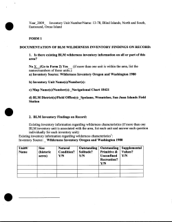
Year 2009 E,N) Inventory Unit Number/Name: 13-93, Unnamed Rocks, (Eliza Rocks W, FORM1 DOCUMENTATION OF BLM WILDERNESS INVENTORY FINDINGS ON RECORD: 1. Is there existing BLM wilderness inventory information on all or part of this area? No_x_(Go to Form 2) Yes__ (if more than one unit is within the area, list the names/numbers ofthose units.): a) Inventory Source: Wilderness Inventory Oregon and Washington 1980 b) Inventory Unit Name(s)INumber(s): c) Map Name(s)INumber(s):_Navigational Chart 18421 d) BLM District(s)/Field Office(s):_Spokane, Wenatchee, San Juan Islands Field Station 2. BLM Inventory Findings on Record: Existing inventory information regarding wilderness characteristics (if more than one BLM inventory unit is associated with the area, list each unit and answer each question individually for each inventory unit): Existing inventory information regarding wilderness characteristics 1: Inventory Source:_ Wilderness Inventory Oregon and Washington 1980 Unit#/ Name Size (historic acres) Natural Condition? YIN Outstanding Outstanding Supplemental Solitude? Primitive & Values? YIN Unconfined YIN Recreation? YIN .. " FORM2 Use additional pages as necessary DOCUMENTATION OF CURRENT WILDERNESS INVENTORY CONDITIONS a. Unit Number/Name: 13-93, Unnamed Rocks, (Eliza Rocks W, E, N) (1) Is the unit of sufficient size? Yes X No Island Rock Rocks [State the BLM acreage ofthe unit. Describe the boundaries of the unit (roads, property lines, etc.) If the area meets one of the exceptions to the size criterion, check "Yes" and describe the exception. If more than one inventory unit is involved, list the acreage in each and evaluate each unit/subunit separately. Complete the analysis for (1), (2), (3),(4) and (5) for each unit or sub-unit. If you check ''No" above, check ''N/A" (Not Applicable) in the remaining boxes below, and you need not provide additional evaluation for the unit or subunit. Use additional space as necessary.] DESCRIPTION OF CURRENT CONDITIONS: (Include land ownership, location, topography, vegetation features and summary of major human uses/activities). Ownership: BLM ownership. Location: West Rocks: N48 38' 57.74", W122 35' 32.32" East Rocks: N48 38' 48.15", Wl22 34' 42.09", North Rocks: N48 39' 39.36", W122 35' 14.14", Topography: Unnamed Rocks (Eliza Rocks, West, East and North) are a grouping of medium sized rocks totaling less than 1 acre in size. The Rocks are predominately low lying and flat. Vegetation Features: Unnamed Rocks supports a variety of lichens and seaweeds. Major human uses/ activities: Recreational boating both motorized and non motorized does occur in the area. Wildlife viewing is excellent in this area for seabirds, marine mammals and other species. Sea Kayaking is also excellent in this area. Unnamed Rocks are located just offshore, approximately 20- 100', from Eliza Island on the west, east and north shore. The grouping of north and west rocks are connected to Eliza Island during low tide events. Other items: Access is best using small non motorized human powered water craft due to numerous submerged rocks in the area and shoreline of Eliza Island. Best access is during low tide. There is WADFW Marine mammal haul out site nearby, site #276. (2) Is the unit in a natural condition? Yes X No N/A Description: Unnamed Rocks appear natural and are in a natural condition. (3) Does the unit (or the remainder of the unit if a portion has been excluded due to unnaturalness and the remainder is of sufficient size) have outstanding opportunities for solitude? Yes X (north rocks) No X (west and east rocks) N/A Description: Unnamed north Rocks do provide outstanding opportunities for solitude. The undeveloped north shoreline of Eliza Island along with the broad Hale Passage and Bellingham Bay dominates the landscape and provides outstanding opportunities for solitude. Unnamed west and east Rocks do not provide outstanding opportunities for solitude. The developed shorelines of Eliza Island dominates the immediate landscape and does not provide outstanding opportunities for solitude (4) Does the unit (or the remainder ofthe unit if a portion has been excluded due to unnaturalness and the remainder is of sufficient size) have outstanding opportunities for primitive and unconfined recreation? Yes No X N/A Description: Motorized and non-motorized boating occurs in the area and is excellent. Outstanding opportunities for primitive and unconfined recreation cannot be found on these unnamed rocks. Sea kayaking, tide pooling, wildlife viewing, and photography are excellent however the small size of the rocks do not provide opportunities for primitive and unconfined recreation. The smaller Rocks are predominately submerged during higher tide events. (5) Does the unit have supplemental values? Yes X No N/A Description: Supplemental values for these Unnamed Rocks include a dynamic marine ecological system. The geology of these Rocks are part of a unique formation regarding Washington State. Other identified values for these Rocks are wildlife, scientific, scenic and cultural. Summary of Findings and Conclusion ... Unit Name and Number: 13-93, Unnamed Rocks, (Eliza Rocks W, E, N) \ Summary Results of Analysis: 1. Does the area meet any of the size requirements? Yes X No Yes X No 2. Does the area appear to be natural? 3. Does the area offer outstanding opportunities for solitude or a primitive and unconfined type of recreation? Yes X (north rocks) NA (west and east rocks) 4. Does the area have supplemental values? X (west and east rocks) Yes X No No X NA Conclusion Check One: X The area-or a portion of the area-has wilderness character. ***Eliza North rocks X The area does not have wilderness character. ***Eliza west and east rocks Prepared by: Team Members: Nick Teague, Outdoor Recreation Planner, 02.04.10 Carla Chalker, Lopez Island Conservation Corps, Volunteer, 02.04.10 (Names, Titles, Date) Approved bx: Field Manager c:M. -.:r-W.H_MwJLAe_ "!/ z.OIZ Date This form documents information that constitutes an inventory finding on wilderness characteristics. It does not represent a formal/and use allocation or a final agency decision subject to administrative remedies under either 43 CFRparts 4 or 1610.5-2. H-6300-1-WILDERNESS INVENTORY MAINTENANCE IN BLM OREGON/WASHINGTON APPENDIX D- PHOTO LOG (modify form as needed) Photographer(s): _ WA Department ofEcology Inventory Area Name & No.: _13-93, Unnamed Rocks, (Eliza Rocks W, E, N) Date Frame# 06.28.2006 04555 06.28.2006 04556 06.28.2006 04557 - 28.2006 04564 06.28.2006 04565 06.28.2006 04565 06.28.2006 04574 06.28.2006 04575 Camera Description Direction Oblique, South shore of Eliza N Island, small grouping of rocks, 2 each Oblique, South shore of Eliza Island, small NNW grouping of rocks, 2 each Oblique, South shore of Eliza NW Island, small grouping of rocks, 2 each Oblique, North shore ofEliza Island, small w grouping of rocks, 2 each Oblique, North shore ofEliza Island, small SE grouping of rocks, 2 each Oblique, North shore ofEliza Island, small SE grouping of rocks, 2 each Oblique, West shore of Eliza Island, small ESE grouping of rocks, 2 each Oblique, West shore of Eliza N Island, small grouping of rocks, 2 each GPSIUTM Location Township Range Sec. East Rocks: N48 38' 48.15", W122 34' 42.09", T36N R2E Sec.5 East Rocks: N48 38' 48.15", W122 34' 42.09 T36N R2E Sec.5 East Rocks: N48 38' 48.15", W122 34' 42.09", T36N R2E Sec.5 North Rocks: N48 39' 39.36", W122 35' 14.14" T36N R2E Sec.5 North Rocks: N48 39' 39.36", W122 35' 14.14" T36N R2E Sec.5 North Rocks: N48 39' 39.36", W122 35' 14.14" T36N R2E Sec.5 West Rocks: N48 38' 57.74", W122 35' 32.32" T36N R2E Sec.5 West Rocks: N48 38' 57.74", W122 35' 32.32" T36N R2E Sec.5 06.28.2006 04555 Oblique, N South shore of Eliza Island, small grouping of rocks, 2 each East Rocks: N48 38' 48.15", Wl22 34' 42.09" T36N R2E Sec.5 06.28.2006 04556 Oblique, NNW South shore of Eliza Island, small grouping of rocks, 2 each East Rocks: N48 38' 48.15" , W122 34' 42.09" T36N R2E Sec.5 06.28.2006 04557 Oblique, NW Southeast shore of Eliza Island, small grouping of rocks, 2 each . . ... 06.28.2006 04564 Oblique, w North shore of Eliza Island, small grouping of rocks, 2 each East Rocks: N48 38' 48.15", W122 34' 42.09" T36N R2E Sec.5 T36N R2E Sec.5 .. North Rocks: N48 39' 39.36", W122 35' 14.14" 06.28 .2006 04565 Oblique, SE North shore of Eliza Island, small grouping of rocks, 2 each North Rocks: N48 39 ' 39.36", W122 35 ' 14.14" T36N R2E Sec.5 06.28.2006 04574 Oblique, ESE West shore of Eliza Island, small grouping of rocks, 2 each West Rocks: N48 38' 57.74", W122 35' 32.32" T36N R2E Sec.5 06.28 .2006 04575 Oblique, N West shore of Eliza Island, small grouping of rocks, 2 each West Rocks: N48 38' 57.74", W122 35' 32.32" T36N R2E Sec.5 13-93, Unnamed Rocks , Eliza Island , North Rocks, N 48 39' 39.36", W 122 35' 14.14"
© Copyright 2026 Paperzz