Vettorato Daniele and Zambelli Pietro, Estimation of energy sustainability at local scale
45th ISOCARP Congress 2009
Estimation of energy sustainability at local scale: an approach based on
innovative analytical and mapping tools and multicriteria analysis
1. Introduction
Global carbon reduction is stated by international community as a necessary target to stop
the climate change [15,51]. However greenhouse gas emissions come primarily from the
combustion of fossil fuels in energy use by world human population and for this reason the
world carbon dioxide emissions are expected to increase, following the present trend of
energy use, by 1.8 percent annually between 2004 and 2030 [22]. More than 50% of world
population today lives in a urban systems [51b] and cities contribute to 67% of world’s
primary energy demand and emissions [23]. Given the projected rate of urbanization, cities
are expected to increase this share to 73% in 2050 [23]. According to WBCSD [54,55]
buildings are one of the largest end users of energy; in OECD countries, the building sector
accounts for 25-40% of the final energy demand, 33% in commercial buildings and 67% in
residential. Worldwide energy consumption for buildings is expected to grow 45% from 2002
to 2025. Rarely were settlements of last century designed to optimize renewable energy use.
According to Butera [03]: “ Usually, when urban planners start the design of a new
settlement, they look for pre-existing landmarks, such as roads, railways, rivers, etc. and
align the new buildings and streets accordingly. Very rarely do they look for the most ancient
pre-existing landmarks: the path of the sun and prevailing winds”.
It is now necessary to renew traditional carbon-spatial development concepts of human
settlements, for example integrating the use of renewable energy in the cities’ structures
[12,13]
Most of the previous attention has been devoted to the smaller scale, in search for better
performances of buildings [03,12,13] in order to save energy (energy efficiency) and to use
renewable energy available on a site. But while energy efficiency is heavily dependent on the
building construction technology the advantages obtained in such a way can be wasted by
the urban form and morphology and by the inappropriate location of buildings that cannot
fully take advantage of potential renewable energy sources available on a territory. Some
methodologies known as Passive and/or Active Houses Design have been elaborated to
model buildings to consume low energy and use renewable energy sources. But some
renewable energy sources (i.e. solar irradiation and geothermal heat), cannot be moved from
a location to another without a very low efficiency. For this reason, renewable settlements
designs presuppose the availability of renewable energy sources in the construction sites
and aim to maximize their use. It can be argued that a strong spatial correlation exists
between the possibilities of renewable settlements and the availability of renewable energy
sources in the building site. In the last few years many town planners have written
monographs promoting various urban designs from the point of view of energy consumption
with the assumption of the integration of renewable energy [31,34,05,56,28]. However, most
contributions address theoretical issues, disregarding actual applications and energy
estimations [07,34,24,37], mainly due to the lack of suitable tools and datasets to rapidly
estimate the potential renewable energy that can be generated by a given territory. In this
sense, there are insufficient case studies to confirm that integrated production of renewable
energy in human settlements is possible and convenient. Moreover, the proposed
methodologies are mainly optimized for new settlement design, but very few studies
contribute to the debate on what can be done with the existing building stock [16,10,43]. This
is especially relevant given growing concern regarding urban sprawl and land take by new
settlements in industrial countries [24].
1
Vettorato Daniele and Zambelli Pietro, Estimation of energy sustainability at local scale
45th ISOCARP Congress 2009
Finally, recent attempts of renewable energy estimation completely lack geo reference
parameters. Usually energy plans do not map the availability of a source in a territory,
omitting those parameters of localization and intensity of renewable energy source that can
suggests solutions and support the design of renewable cities [13]. Up to date tested
methodologies to integrate energy parameters in urban planning are missing.
Recent attempts of potential renewable energy mapping were published and reward by
international community [44, 48, 26,27,35,36] even if the methodologies used suffer from a
lack of precision with very high approximations and very wide scales, underlining the
importance of mapping renewable energy and the need of methodologies that can provide
good estimations at local scales.
2. Objective and method
This paper describes a methodology for spatially comparing the renewable energy
potentialities with the energy demand of buildings at local scale. The methodology is based
on maps overlay and multicriteria analysis. The maps of potential renewable energy for some
renewable energy sources are compared with the map of energy demand of buildings to
spatially estimate the level of potential energy sustainability at local scale.
The presence of renewable energy sources in a territory depends on its environmental
characteristics [02_a]. For example solar irradiation is heavily affected by the latitude,
climatic variables (mainly cloud coverage and atmospheric turbidity) and morphology, the
hydro electric potential is influenced by morphology and water availability, the geothermal
potential is influenced by geological characteristics and water presence in the underground,
the wood biomass energy potential is influenced by the presence of forests, and so on.
It is possible to estimate the spatial distribution of potential renewable energy stocks by the
analysis of territory’s environmental characteristics.
This paper focuses on those renewable resources recognized by a wide literature review as
having limited environmental impact and which can be integrated in urban systems [12, 43].
In particular the parameters used to choose resources for mapping were:
-
Limited lancover change;
Limited environmental impact;
Possible integration with the settlement system;
Availability of the resource in the territory;
Availability of technology to use the resource;
Affordable implementation costs.
To check the availability of the resource in the territory the Energy Plan for Trentino Province
[40, 11] was used.
The final list of renewable sources taken into account in this study includes:
-
Solar energy potential (Photovoltaic and Thermal) from the building’s roofs surfaces
Hydroelectric energy potential form existing potable water plant;
Wood biomass energy potential from net primary productivity of forests;
Ground-source geothermal energy potential.
Literature provides many methods to estimate the energy demand of buildings. They are
mainly based on the identification of physic parameters that affect the energy demand. In
particular these design models are based on thermodynamic energy balance calculation and
handle parameters such as local climate conditions (latitude, altitude and weather
2
Vettorato Daniele and Zambelli Pietro, Estimation of energy sustainability at local scale
45th ISOCARP Congress 2009
conditions), exchange of energy between buildings and environment (transmittance of
materials, ventilation) and availability of renewable energy (passive solar design) [02].
Multi-Criteria Analysis (MCA) is a decision-making tool developed for complex problems. It is
used in this analysis to find the congruence function between spatial distributions of
renewable energy sources and energy demand of existing buildings stock in order to
estimate the potential energy sustainability at local scale.
2.1 Estimation of Solar energy potential
The source of solar energy is the electromagnetic radiance emitted by the sun. This is
measured in W•m2. The energy flux can reach, in clear sky condition and optimal solar
position and surface inclination, 1000 W•m2. This irradiation measure takes into account the
exposition time and is measured in MJ•m2 or in kWh•m2. The irradiation is subdivided in
“direct” , “diffused” and “reflected”. Direct irradiation is referred to clear sky. In turbid
atmospheric conditions the diffuse irradiation increases while the direct one decreases.
Reflected irradiation is produced by land surface. The total amount of irradiation is called
“global irradiation”.
The most common technologies available today for production of solar energy are thermal
and photovoltaic solar panels. They can be installed on the ground or on the roofs of
buildings. Due of the land consumption of ground solar panels only roof solar panels were
taken into account in this study.
The solar panel technology available today mainly uses the direct irradiation [15]. For this
reason in the estimation of potential solar energy by solar panels only the direct irradiation is
included.
The algorithm used to calculate the solar irradiation in this case study is implemented in the
Open Source GIS software GRASS 6.4 [20], where the direct radiation normal to direct sun
B0c [W·m-2] is attenuate by atmosphere and calculated in the model as follows [29]:
B0c = G0 exp {-0.8662 TLK m dR(m)}
where:
-0.8662 TLK is the atmospheric turbidity factor ; m is the ’ “optical air mass” calculated using
the formula; dR(m) is the “Rayleigh optical thickness at air mass m” [29].
2.2 Estimation of ground-source geothermal energy potential
The ground-source geothermal energy also known as geothermal heat pump or ground
source heat pump (GSHP) is a central heating and/or cooling system that pumps heat to or
from the ground, usually not exceeding a depth of 150 m. It uses the earth as a source of
heat (in the winter), or as source of cold (in the summer). This design takes advantage of the
moderate below ground temperatures to boost efficiency and reduce the operational costs of
heating and cooling systems, and may be combined with solar heating to form a geo-solar
system with even greater efficiency. [42,31,34]
Following the methodology published in [06,04] the potential low enthalpy geothermal energy
is function of the characteristics of underground material and of the presence of underground
water. The intensity of low enthalpy geothermal energy can be mapped crossing these
parameters.
3
Vettorato Daniele and Zambelli Pietro, Estimation of energy sustainability at local scale
45th ISOCARP Congress 2009
Usually the underground temperature at a depth of 10m is equal to the mean annual
temperature of the place and increases of 1°C every 33 meters. The thermal conductibility of
the ground depends on the characteristics of the thermal conductivity of underground
materials which increases with the presence of water [04].
Because of GSHP technology can use the underground water or modify its temperature the
areas of hydro resources protection must be excluded [40,41].
2.3 Wood biomass potential energy estimation
Following the methodology used in [32,49] a mature forest usually has a positive annual net
productivity. This amount of biomass can be extracted without compromising the internal
equilibrium of the ecosystem. The potential energy from wood biomass depends on:
-
Annual average net productivity of an area;
Accessibility to the area;
Compatibility with ecosystem conservation and other uses (i.e. tourism);
Distance of the area of production from the area of consumption.
The availability of wood biomass for energy production can be mapped crossing these
parameters.
2.4 Potable water pipes potential energy estimation
Potable water pipes can be a source of renewable energy if used in combination with
turbines [41]. Even if a standard methodology to estimate the potential energy produced in
this way is not available, is easy to demonstrate that the amount of energy that can be
produced is function of the quantity of water that pass through a pipe (litres for seconds) and
of the slope between two nodes of the pipe network. The amount of water that passes
through a pipe is function of the average consumption of water of the population served by
that pipe.
Mapping the population density and crossing it with a pipe network map, it is possible to
estimate the amount of water that passes through a pipe. By including information about the
slope of the pipe it is then possible to estimate the potential energy produced by a turbine
located at the end of the pipe.
2.5 Energy demand of buildings
Following the methodology published in [02] we find the intensity of energy demand for
heating buildings is function of several parameters: climate conditions, volume, age and
building type, life styles. In particular this methodology uses the energy balance to calculate
the building energy consumption. The difference between external and internal temperature
and the insulating parameters of buildings are used to calculate the energy dispersed by
transmission and some standard coefficients are used to estimate the energy dispersed by
ventilation (i.e. volume of daily changed air). For the calculation formulas and coefficients
refer to [02].
2.6 Multicriteria analysis
Decision makers historically have cited inaccessibility of required geographic data and
difficulties in synthesizing various recommendations as primary obstacles to spatial problem
solving. Multicriteria decision analysis offer a variety of techniques and practices to uncover
and integrate decision makers’ preferences in order to solve “real-world” GIS-based planning
and management problems. To solve spatial decision problems recently researchers have
introduced spatial criteria into multicriteria analysing. [50,18] Spatial multicriteria analysis is
4
Vettorato Daniele and Zambelli Pietro, Estimation of energy sustainability at local scale
45th ISOCARP Congress 2009
used to find the congruence function between energy demand and the potential renewable
energy availability.
3. Application to the case study
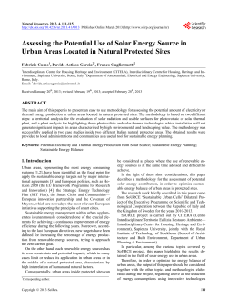
The study area is Roncegno Terme (pop. 2700) an alpine municipality, located in the
Valsugana Valley (Trentino, northern Italy) [fig.1]. The area is characterized by a narrow
valley floor surrounded by mountains reaching about 2200 m a.s.l.. The urban morphology
follows the land morphology complexity, as the town grew by adapting its design to the flood
risk free valley floor areas, and the most gently sloped alluvial fans [09,08]. The settlement is
mainly facing South and has an average elevation of 300 m a.s.l. The overall building stock
includes approximately 1400 buildings, covering a land area of 230.000 m2. The average
building area is 164,5 m2.
fig 1. Case study area. Roncegno Terme Municipality. Trentino Alto Adige, Italy.
3.1 Mapping the Potential solar energy (fig. 4a)
Vettorato and Geneletti [53] have previously shown the estimation of potential solar
irradiation in the case study area is a function of [34, 35, 33, 32]:
-
the real orientation of buildings, that is not optimized to exploit solar irradiation;
the roofs form and inclination;
the interaction between buildings and between buildings and urban vegetation that
can create shadow zones;
the land morphology that produce shadows zones over buildings that vary following
the sun ground elevation and seasons.
The GeoDataBase (Coordinate system: UTM WGS84, zone 32) used in this study consists
of:
-
1-m horizontal resolution DSM of the study area (administrative borders of the
municipality of Roncegno Terme) obtained by the LiDAR [rif] dataset produced by
Province of Trento in 2007. The vertical resolution is between 25 and 45 cm [30]. The
LiDAR survey was carried out during the winter season, when the foliage of
deciduous trees is reduced;
5
Vettorato Daniele and Zambelli Pietro, Estimation of energy sustainability at local scale
45th ISOCARP Congress 2009
-
1:5.000 map of existing buildings, derived by orthophotos acquired in 2006 and
provided by Province of Trento;
10-m Digital Elevation Model (DEM) generated in 2000 and provided by the Province
of Trento.
As mentioned the irradiation model includes all those variables that can affect solar
exposition of roofs. The LiDAR DSM describes with accuracy and precision the objects that
are located on the land surface and that are larger than 1 meter (buildings, trees, etc.). The
10-m resolution DEM was used to calculate the shadows produced by mountains over the
settlement. The “linke turbidity factor” that approximates the radiation absorption by
atmosphere was provided by a database compiled by the JRC [29].
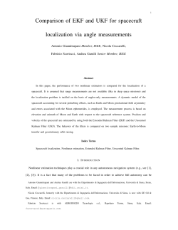
fig.2 Municipality of Roncegno Terme. Overlay between Vector Numeric Cartography of buildings and
2
solar irradiation map in Wh•m •day. [53]
The calibration of the model was performed using the Meteo station located in Borgo
Valsugana that record the global irradiation in a point. The average global irradiation of the
last 3 years was calculated and compared with the one calculated by the model at that
location.
fig 3: Comparison between theoretical estimation values (red) and measured (blue).
The suitability of roofs to host photovoltaic or thermal panels was estimated using the energy
payback time of the technology in comparison with the energy produced [01, 52]. The results
shows that, for the case study area, thermal panels are suitable for roof with an irradiation
from 500 KWh/m2/year and above, while photovoltaic panels are suitable for roofs with an
irradiation from 1200 KWh/m2/year and above.
6
Vettorato Daniele and Zambelli Pietro, Estimation of energy sustainability at local scale
45th ISOCARP Congress 2009
3.2 Mapping ground-source geothermal energy potential (fig. 4b)
The dataset used to map the low enthalpy geothermal potential energy is composed by:
-
Geologic survey 1999 [17] of the first 200 meters below ground;
Hydro resources map of Trentino Province [38]
Based on [04] and [46, 47] a geothermal suitability factor was attributed to each type of
underground material. Finally the overlay with the hydro resources map gave a suitability
map for low enthalpy geothermal application.
3.3 Mapping wood biomass potential energy (fig. 4c)
The 2007 Forestry Service database of Trentino Province [39] was used to extract
information about the net production of wood biomass for the Roncegno Municipality territory.
The methodology used follows the indication provided by [32, 49]. The parameters used for
the estimation are:
-
estimated net production of the area useful for extraction,
slope of the area (to allow the accessibility),
compatibility with other uses of the land.
The analysis provided the map in Tons per years for the different areas to design the
suitability map of energy production from wood biomass.
3.4 Mapping potential energy from potable water pipes (fig. 4d)
The map of the water pipes was provided by the Municipality of Roncegno. The map was
crossed with the DTM (10 meters resolution) provided by Trentino Province in order to
calculate the slope for each pipe. The estimation of water routed by each pipe was calculated
by crossing the location of water distribution nodes with the number of inhabitants served by
that node. The average daily per capita consumption of potable water was obtained by the
national statistics on water consumption [25]. The final estimation integrates the data on
water flux in a node with the average of turbine performances available in the market to
calculate the KWh that can be produced. Finally the suitability factors for hydroelectric
energy production form potable water pipes were attributed to each area.
3.5 Mapping the energy demand (fig. 5)
To build up the dataset to analyze the energy demand, according to the Municipality, a
survey was made, distributing 900 forms by mail to the 900 families of Roncegno Terme
obtaining 350 valid forms (close to 40% of the total). The questions in the form regarded the
characteristics of family and buildings, including questions on energy systems and
consumption of buildings. The addresses of buildings were also recorded to allow postprocess geocoding [19] of the answers. Because a geocoded address database was not
available in the Municipality of Roncengo some free geocoding tool available online were
tested. In particular the ESRI address geocode database [14] that for Europe uses the
TeleAtlas 2007 database [14], the GoogleMap geocode Api [19] that for Italy uses the
GeoNext database, and the Yahoo geocode service were tested [57]. The best results for
Roncegno Terme area were obtained by the GoogleMap geocode Api which recognized 95%
of the addresses. The methodology used to estimate energy demand of buildings is
published in [02]. The geocoded informations were then interpolated with Inverse Distance
Weight algorithm (IDW) [45, 30] for urbanized areas obtaining a map of energy demand
intesity.
7
Vettorato Daniele and Zambelli Pietro, Estimation of energy sustainability at local scale
45th ISOCARP Congress 2009
fig 4a: Beam solar irradiation map (Wh/m2/day ,
annual average)
fig 4b: Geothermal energy map. Areas with
suitability for GSHP installation.
fig 4c: Wood Biomass availability map.
fig 4d: Potable water pipes network: served areas
with suitability for hydroelectric turbines
installation.
8
Vettorato Daniele and Zambelli Pietro, Estimation of energy sustainability at local scale
45th ISOCARP Congress 2009
fig 5: Map of energy demand of buildings
3.6 Spatial multicriteria analysis
This stage of analysis is still work in progress.
The integration between potential renewable energy and energy demand was made using
multicriteria-spatial approach. In particular spatial-multicriteria analysis is used to find
congruence criteria and spatial correspondence between energy demand and renewable
energy availability in a site.
The main used criteria are:
-
spatial correspondence between location of energy demand and location of
renewable energy availability (including intensity).
-
costs and availability of the technology to exploit the renewable energy (initial cost,
maintenance cost, energy payback time);
-
expert opinion and knowledge about viability of renewable technology (policies,
environment and landscape impacts, etc.) [18].
Depending on the decision rules used in the multicriteria model, different scenarios can be
obtained for the different areas of Roncegno, in order to optimize the use of renewable
energy available in a site. Moreover different levels of sustainability can be estimated.
4. Discussion and Conclusions
This paper provides a contribution to the disciplinary debate, with reference to energy
aspects, on the evaluation of urban sustainability as function of urban form. This paper
demonstrates that the estimation of potential renewable energy is possible with the
methodologies available today. Although the proposed approach for the estimation of
potential renewable energy at an urban scale is still under refinement, the preliminary results
9
Vettorato Daniele and Zambelli Pietro, Estimation of energy sustainability at local scale
45th ISOCARP Congress 2009
encourage continuing the research in this direction. The goal is to obtain a more accurate
spatial estimation of potential renewable energy production and energy demand that can be
compared and used as a parameter in the policy making processes.
From an operational standpoint, the research has experimented with the application of
several methodologies, datasets and software to calculate the potential renewable energy of
a settlement. In the future the methodology will be improved, in particular:
-
-
-
-
-
-
In the estimation of solar irradiation: future improvements should use sensors located
to collect data about solar beam irradiation useful in calibrating the theoretical model.
The LiDAR dataset should be also handled to obtain best results in urban morphology
description.
In the estimation of potential ground-source geothermal energy the used dataset was
incomplete and many approximations were necessary. Field surveys are needed to
precisely map underground materials and presence of water. In addition the
individuation of hydro-sources protection areas has to be more precise.
In the estimation of wood biomass potential energy: future improvements in the
methodology should consider the use of the forest path map and of the least cost
path analysis to better assess the accessibility to the resource.
In the estimation of potential energy from potable water pipes: future improvements
should consider field surveys to validate the methodology used to calculate pipe
capacity.
In the estimation of energy demand: future improvements in the methodologies
should also take into account the dataset provided by energy companies that
distribute energy in the case study area(which for technical reasons were not
available for this study). The mapping of energy demand should consider different
sectors of energy consumption, dividing for example thermal and electricity energy
demand, residential, commercial and industrial, etc. The geocoding process,
necessary to map the energy demand, felt the effect of the geocode database errors.
Even if the Google geocode Api provided the best result , in terms of recognized
addresses, in comparison with the other databases, it is necessary to check the
accuracy and the precision of the database with a GPS field survey.
The multicriteria analysis, in this stage of the work, was very basic and lacks any
sensitivity analysis. Future improvement should experiment with different criteria and
software to provide different scenarios of renewable energy use. In particular the best
congruence function between energy demand and renewable energy availability has
to be found taking into account the different scales and characteristics of renewable
energy sources and demands.
In general, this analysis of the demand of energy and the potential renewable energy could
be calculated in KWh and easily compared with the performances of traditional fossil
systems.The estimation of potential renewable energy for a given territory is certainly a
parameter that can support policy making processes related to energy and urban policies,
plans and programs. The possibility, recently shown by prominent authors [13], of connecting
a grid or network of several sources of renewable energy production underlines the role of
the city as a potential power plant. Further development of the proposed approach should
consider also the performances of the different technologies available on the market allowing
the estimation of the amount of KWh that can be produced by potential renewable energy.
Daniele Vettorato, PhD candidate. in Environmental Eng, Italy. [email protected]
10
Vettorato Daniele and Zambelli Pietro, Estimation of energy sustainability at local scale
45th ISOCARP Congress 2009
Referencies
[01] Ardente, Beccali, Cellura, Lo Brano,2005. Life cycle assessment of a solar thermal collector: sensitivity
analysis, energy and environmental balances - Renewable Energy 30
[02] Baggio P. 2000, Progetto per lo sviluppo sostenibile del trentino, Trento.
[03] Butera F. (2008) in: Urban Energy Transition: From Fossil Fuels to Renewable Power Droege P., ed.
Elsevier Science; 1 edition, Oxford.
[04] Cambrusano F. , 2008. Impianti geotermici a pompa di calore. Cuneo.
[05] Capello R.,Nijkamp P., Pepping P., (1999) Sustainable Cities and Energy Policies. ed. Springer, New York.
[06] CAPGAI 2009. Corsi di Geologia applicata all’Ingegneria. Materiale del corso. Trento.
[07] De Pascali P., (2008). Città ed energia. La valenza energetica dell'organizzazione insediativa, ed. Franco
Angeli, Milano.
[08] Diamantini C., a cura di, (2005). Temi e indicatori di Sostenibilità Ambientale in una regione alpina. . Temi
ed., Trento.
[09] Diamantini C., a cura di, (1996). Gli ambienti insediativi del Trentino e dell’Alto Adige, ed. ITATEN, Roma.
[10] Diappi L. (a cura di), (2000). Sostenibilità Urbana. Dai principi ai metodi di analisi, forma urbana, energia e
ambiente, ed. Epitesto, Milano.
[11] DICA 2007. Rapporto sullo stato dell'arte delle energie rinnovabili e sulle possibili applicazioni in Trentino.
Dipartimento di Ingegneria Civile ed Ambieantale, Trento.
[12] Droege P., (2008) . Urban Energy Transition: From Fossil Fuels to Renewable Power , ed. Elsevier Science;
1 edition, Oxford.
[13] Droege P., (2007) . The Renewable City: A comprehensive guide to an urban revolution, ed. Wiley,
Chichester, UK.
[14] Esri 2009. An overview of geocoding. ESRI
http://webhelp.esri.com/arcgisdesktop/9.2/index.cfm?TopicName=An_overview_of_geocoding (on 01/07/2009).
[15] EU European Union, (2008). Pacchetto 20-20-20, clima ed energia.
[16] Farr D., 2008. Sustainable Urbanism: Urban Design With Nature, ed. Wiley, New York.
[17] Felber et al. 1999. Geological Survey – Trentino. Servizio Geologico PAT. Trento. [15] FVG Energy, Energia
Solare in Italia http://www.fvgenergy.com/energia_solare_ita/energia_solare_chi_siamo.html. (last visit 1st feb
2009)
[18] Geneletti, D., 2005. Formalising expert’s opinion through multi-attribute value functions. An application in
landscape ecology. J. Environ. Manage., 76, 255-262
[19] Google 2009. What is Geocoding? Google http://code.google.com/intl/itIT/apis/maps/documentation/geocoding/#Geocoding . (on 01/07/2009).
[20] GRASS GIS (2009) http://grass.itc.it/ (last visit: Jan 2009)
[21] Hanova, J; Dowlatabadi, H 2007, Strategic GHG reduction through the use of ground source heat pump
technology, Environmental Research Letters (UK: IOP Publishing) 2: 044001 8pp, ISSN 1748-9326
[22] IEA (2008) Greenhouse Gases, Climate Change, and Energy, Brochure #: DOE/EIA-X012
[23] IEA, (2008). World Energy Outlook 2008. IEA
[24] Ingersoll R., (2004). Sprawl Town. ed. Maltemi, Roma.
[25] ISTAT 1999 . Indagine sulle reti di distribuzione dell’acqua potabile. Istituto Nazionale di Statistica. Roma.
[26] Ivanov P., St. Lingova, L. Trifonova, D. Renne, and J. Ohi. 1996a. An investigation of renewable resources
and renewable technology applications in Bulgaria. Environmental Management, 20(Suppl 1):583–593.
[27] Ivanov P., St. Lingova, L. Latinov, and L. Trifovova. 1996b. Stage 4.4 The geographical distribution of solar
and wind energy potential. Inventory of biomass. Determination of the availability of renewable energy resources.
Screening of renewable technologies and determination of renewable energy available to specific technologies.
Calculations of total, accessible and reserve resources. Cost effectiveness of renewable energy, feasibility and
barriers to the implementations. Report on renewable energy presented to the Departmentof Energy of the US
and Energoproekt as a part of the ‘‘Bulgarian country study to address climate change inventory of the
greenhouse gases emission and sinks, alternative energy balances, and technology programs,’’ Sofia., April, p.
162.
[28] Jenks M., Dempsey N., (2005). Future Forms and Design for Sustainable Cities, ed. Elsevier/Architectural
Press, Oxford.
[29] JRC, Joint Research Center, UE. Solar Model R.SUN, http://re.jrc.ec.europa.eu/pvgis/solres/solmod3.htm
(last visit: Jan 2009)
[30] Liszka, T. (1984). "An interpolation method for an irregular net of nodes". International Journal for Numerical
Methods in Engineering 20 (9): 1599–1612. doi:10.1002/nme.1620200905.
[31] Los S., Natasha Pulitzer, 1985. L’Architettura del Regonalismo. Guida alla progettazione bioclimatica nel
Trentino, ed. Provincia Autonoma di Trento, Servizio Energia, TEMI, Trento. [01_d] UN 2007, State of world
population 2007, Unlesaing the potential of Urban Growth, UNFPA (www.unfpa.org)
[32] Lubello 2008, Phd Thesis, A rule-based SDSS for integrated forest harversting planning. Università degli
Studi di Padova. Padova.
[33] Lund, J.; Sanner, B.; Rybach, L.; Curtis, R.; Hellström, G. 2004, Geothermal (Ground Source) Heat Pumps, A
World Overview, Geo-Heat Centre Quarterly Bulletin (Klmath Falls, Oregon: Oregon Institute of Technology) 25
(3): 1–10, ISSN 0276-1084
[34] Lyle John Tillman, (1994). Regenerative Design for sustainable Development, ed. Wiley, Pomona, California.
11
Vettorato Daniele and Zambelli Pietro, Estimation of energy sustainability at local scale
45th ISOCARP Congress 2009
[35]Maxwell, E. L., and D. S. Renne. 1994. Measures of renewable energy resources. NREL/MP-463-6254,
National Renewable Energy Laboratory, Golden, Colorado.
[36] Meridian Corporation 1989. Characterization of US energy resources and reserves. DOE/CE-0279. US
Department of Energy, Assistant Secretary Conservation and Renewable Energy, Office of Research and
Technology Integration, Washington, DC.
[37] Mega V., (2005). Sustainable Development, Energy and the City: A Civilisation of Concepts and Actions,
Springer, New York.
[38] PAT 2007. Carta delle risosrse idriche. Servizio Geologico Provincia autonoma di Trento. Trento.
[39] PAT 2007. Piano di assestamento forestale 2007. Servizio Forestale Proviancia autonoma di Trento.
Trento.
[40] PAT 2007, Piano energetico-ambientale provinciale, Provincia Autonoma di Trento - Servizio Energia, Trento.
[41] Provincia di Belluno 2009. Mini centrali idroelettriche su acquedotto. Belluno Province, Bim Gestione Servizi
Pubblici. Belluno
[42] Rafferty, Kevin 2001, An Information Survival Kit for the Prospective Residential Geothermal Heat Pump
Owner, Geo-Heat Centre Quarterly Bulletin (Klmath Falls, Oregon: Oregon Institute of Technology) 18 (2): pp 1–
11, ISSN 0276-1084
[43] Randall T., (2008). Sustainable Urban Design: An Environmental Approach, ed. Taylor & Francis, New York.
[44] San Francisco 2009. Solar irradiation map. http://sf.solarmap.org/# (on 01/07/2009)
[45] Shepard, Donald (1968). "A two-dimensional interpolation function for irregularly-spaced data". Proceedings
of the 1968 ACM National Conference: 517–524. doi:10.1145/800186.810616
[46] SIA-Documentation D 0190. Utilisation de la chaleur du sol par des ouvrages de fondation et de soutènement
en béton. http://www.geothermie.ch/
[47] SIA-Dokumentation D 0179, Energie aus dem Untergrund. Erdspeicher für moderne Gebäudetechnik.
http://www.geothermie.ch/
[48] Schneidera Daniel R., Neven Duića,and Željko Bogdana, 2006. Mapping the potential for decentralized
energy generation based on renewable energy sources in the Republic of Croatia. Energy Volume 32, Issue 9,
September 2007, Pages 1731-1744
[49] Scalet S., 2006. Thesis. Potenzialità delle biomasse legnose e fabbisogno termico in Primiero. Università
degli studi di Trento. Trento.
[50] Sharifi, M.A. & Zucca , 2009. Integrated planning and decision support systems: Concepts and application to
a site selection problem. In D. Geneletti & A. Abdullah (Eds.), Spatial decision support for urban and
environmental planning. A collection of case studies (pp.5-31). Kuala Lumpur: Arah Publications.
[51] UN United Nations, 1998. Kyoto protocol to the United Nations Framework convention on Climate Change.
Kyoto.
[51b] UN United Nation, 2007. United Nation Population Fund. http://www.unfpa.org
[52] Vasilis Fthenakis and Erik Alsema, 2006. Photovoltaics Energy Payback Times, Greenhouse Gas Emissions
and External Costs: 2004–early 2005 Status. PROGRESS IN PHOTOVOLTAICS: RESEARCH AND
APPLICATIONS Prog. Photovolt: Res. Appl. 2006; 14:275–280
[53] Vettorato D. and Geneletti 2009, Estimation of potential solar energy at urban scale: An approach based on
LiDAR images analysis. INPUT 2008 Conference, Lecco.
[54] WBCSD (2008) Energy efficiency in buildings, World Business Council for Sustainable Development.
[55] WBCSD (2008) Transforming the market: Energy efficiency in buildings. World Business Council for
Sustainable Development.
[56] Williams K.,Burton E.,Jenks M., (2000). Achieving sustainable Urban Form, E&FN Spon, London.
[57] Yahoo 2009. Geocoding. Yahoo. http://developer.yahoo.com/maps/rest/V1/geocode.html (on 01/07/2009).
12
© Copyright 2026 Paperzz