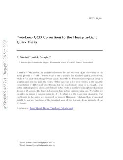
GEOPHYSICAL
RESEARCH
LETTERS,
VOL.19,NO.14,PAGES
1487-1490,
luly24,1992
PRECISEDETERMINATION OF EARTH'S CENTER OF MASS USING
MEASUREMENTS FROM THE GLOBAL POSITIONING SYSTEM
Yvonne
Vigue,Stephen
M. Lichten,
Geoffrey
Blewitt,
MichaelB. Heflin,andRajendra
P. Malla
JetPropulsion
Laboratory,
California
Institute
ofTechnology
Abstract.GlobalPositioning
System(GPS)datafroma
ranging(SLR)andverylongbaseline
interferometry
(VLBI)
worldwidegeodeticexperimentwere collectedduringa 3
data.TheSV5 scaleandoriginarefromSLR, andtheorigin
weekperiodearlyin 1991. We estimated
geocentric
station ischosento be thegeocenter.
coordinates
usingtheGPSdata,thusdefininga dynamically
SinceGPS satellitesmovein high-Earthorbits,they are
determined
reference
frameoriginwhichshouldcoincide
with
relativelyinsensitive
to errorsin thegravityfield,particularly
theEarthcenterof mass,or geocenter.The 3-weekGPS avforrelatively
shortdataaresof a fewdaysor less[Bertigeret
erage
geocenter
estimates
agreeto 7-13cmwithgeocenter
esal., 1986]. Witheachgroundsitetracking5-6 GPSsatellites
timates
determinedfromsatellitelaserranging,a well-estabthegeocenter
canbe estimatedquickly(in a
lished
technique.The RMS of daily GPSgeocenter
estimates simultaneously,
few
days
or
less).
Use
of
GPS
with shortarcsto quickly
were4 cm for x andy, and30 cm for z.
determine
thegeoeenter
wouldin principleenabletimevariaIntroduction
Thesatellitesof theGlobalPositioning
System(GPS)can
beusedto preciselymeasure
globalgeodynamical
quantities
suchas changesin Earth'srotationvector and rotationrate,
crustalmotion, and location of the Earth's center of mass.A
recent
opportunityto testthesecapabilities
was providedby
the1991G._PS
I_ERS(InternationalEarth RotationService)
andG._eodynamics
experiment(GIG), whichtookplaceJan
22- Feb13 1991. Althoughonly 15 GPSsatelliteswereoperational,the GPS constellation will include 24 satellites
whencompleteandsubstantial
improvement
in theaccuracy
ofgeodetic
measurements
is expectedin the nextfew years.
TheEarthorientation
andbaselineresultsrecentlypublished
(Herringet al., 199!, Heftinet al, 1992,Lichtenet al., 1992,
Lindqwister
et al., 1992) showthatevensuchlimitedGPS
dataprovided
centimeter-level
accuracy
formeasurements
of
Earthorientation
variations
andgroundstationbaselines.
Thelocationof the Earth'scenterof mass,or geocenter,
is
afundamental
measurement
whichhasgeophysical
andpracticalsignificance.The definitionof a terrestrialreference
frame
requires
specification
of theorigin,scale,andorientationof a coordinate
system.Sincethemassdistribution
of
theEarthis constantly
changing,
it is important
to measure
thetimevariations
of thegeocenter
relativetopoints
onthe
Earth's
crust.Sincegeodetic
measurements
areoftenmade
withdifferent
techniques
andinstruments
inslightly
different
terrestrial
reference
frames,precise
measurement
of theorigin,scale,andorientationof theseframesrelativeto onean-
other
is needed
in orderto combine
differentgeodetic
data.
tionsovera few daysor lesstobe measuredfor thefirsttime,
withoutcomplications
of re-estimation
of thegravityfield. In
thispaper,we presentthe firstdecimeter-quality
GPS solutionsfor the geocenterwhich we obtainedfrom 21 daysof
data.We discuss
notonlyaccuracy
by comparingwith other
independent
data,butalsoshort-term
(daily) precisionof the
estimates
andthepotentialfor furtherimprovement.
Over100 globallydistributed
trackingsitesparticipated
in
theGIG'9! experiment.Only datafrom the 21 RogueGPS
receiversites(Fibre 1 andTable1) wereusedin our analysis. The Rogue receiveris describedby Srinivasanet al.
[1989]. Thesitescover+79øto -35ølatitude,butonly4 of
these21 siteswerelocatedin thesouthernhemisphere.Data
from Jan 31 and Feb 13 were not includedin this analysis
sincean inputerrorin antennaheightwas discovered.Data
fromsatellitePRN6 wasnotusedbecauseit wasspinning.
EstimationStrategy
The data collectedduringthe GIG'91 experimenthave
beenprocessed
usingtheGIPSY (GPSInferredPositioning
SYstem)software[LichtenandBorder,1987;Soversand
Border,1990]. A standard
estimation
technique
is usedin
thisanalysis,consisting
of single-dayare solutions.Three
sites are fixed as fiducial sites in the SV5 reference frame,
while all other station locationsare estimated. A fiducial network can establish a well-defined terrestrial reference frame
with2 or 3 receivers
fixedto theirknowncoordinates
[MaIla
and Wu, 1989]. The fixed vectorsbetweenfiducialsites
defineorientation
andscalein accordance
with SV5 [Murray
Oeocenter
estimates
presented
inherearebased
ona compar- et al., 1990]. The fiducia!sadoptedfor this studyare
Norway;Pinyon,California(USA); andWettzell,
ison
withtheSV5reference
frame[Murray
etal.,1990]ori- Troms½,
gin. TheSV5 frameis constructed
fromboths..atellite
l_aser
Germany.
Satellite
orbits,non-fiducial
station
locations,
and
3 components
of thegeocenter
offsetfromthenominal
origin
are estimated. The satellite orbits are estimated about a
Copyright
1992by theAmerican
Geophysical
Union.
Papernumber92GL01575
0094-8534/92/92
GL-01575503.00
dynamically
definedoriginwhichdetermines
theEarth's
centerof mass,or geocenter.The 3 estimatedgeocenter
parameters
represent
a translational
offsetbetween
theorigin
of thereference
frameandthedynamical
origindefinedby the
1487
1488
Vigueetal.' Precise
Determination
ofGeocenter
UsingGPS
90i I
/FA,
I
' II•.ALL i ..... I
__y
o•L
'•-u •_
ou _J••OLD•LG•'SCR••
/ MA•
40
.....
•St St)_
0-
•
-
-30-
i
' '1 '
i
-60
I
0
!
60
I
120
....
-40
I
180
.....
....
:.:
.................
..................
I.....................
...............
)[
.....
L..:..
.........
. .....
.......
[., geoc
X Xmean
= -8.3cm,rms
=4.0crn!
/i/ .........
'•g;:%"¾'
.......
'?'"/ii';/i'ii'-::"i'5':':F•"//i•"F•i'F:'"•/:'
L__
20
I
I
25
30
, ,
I
I
35
40
J
45
Dayof Year(1991)
lo.gitude(deg)
Fig. 1' GIG'91 G•S RogueReceiver•cations
GPS orbits.Thusgeocentricstationlocationsaredetermined
I
..... ....
.......
-30
I
-120
!
10
-20
-90
-180
'
..............................
..2...1..d.a...y.s:
Stations
Combined
a 4o
-d0 -
I
30
Fig. 2: GPSGeocenter
Estimates
- x,y comp.
forx andy components,
respectively;
thesevaluesrepresent
thedifferencebetweentheGPSsolutionfor thegeocenter
and
the nominalvalues,which are basedon yearsof SLR data
andarebelievedto be accurate
to betterthan5 cm [Eanes
et
at., 1990]. Thedailyrmsscatteraboutthemeanfor thex and
transmitter/receiver clocks were also estimated. Details on the
y componentsof the geocenterare 4.0 cm and 4.4 cm, reestimation
strategy
aregivenbyLichten[1990a,1990b].
spectively. This daily rms scatteris a measureof internal
An alternativeno-fiducial techniquedemonstrated
by
precisionof the techniquepresented
here,andcanbe considHeftineta!. [1992]involves
estimating
all station
coordinates eredan indicationof the potentialto measurevariationsin the
andsatellitepositions
withveryweakconstraints
(~1 km).
geocenteroverone day.
This definesa rigidnetworkwhichhasan ill-conditioned
oriThe estimates
for thegeocenter
z component
from3 weeks
entationbutisnevertheless
constrained
by thedatatothegeoof GIG'91 data are shownin Figure 3. This component
centerthroughthe dynamicsof the GPS satellites.To define
showslargervariationsthanthex andy components,
butwe
geocentric
coordinates,
thenetworkcanbe translated,
rotated,
do not believethat theseresultsshowactualdaily centerof
andscaledintothereference
frameof choice(e.g.,SV5).The
mass variations. The 3-week weighted mean offset from
3 estimatedtranslational
parameters
arethegeocenter
offset
nominalfor the z componentis 7.7 cm, while the dailyrms
fromtheoriginof thisframe[B!ewitt
etal., 1992].
scatteris 30 cm. It is likely that the estimationof this
componentis muchmoresensitiveto the unevendistribution
forall non-fiducial
sites.Earthorientation
parameters,
3 solar
radiationcoefficients
persatellite,GPScarrierphasebiases,
randomwalk zenithtroposphere
delaysfor eachsite, and
Results and Discussion
Figure2 showsdaily x andy geocenter
component
estimates as offsets from the nominal values. The nominal values
usedfor eachcomponentof the geocentercomefrom the
globalSV5 stationlocationsolutions.The x andy componentsof thegeocenter
exhibitvariations
whichappearto be
negativelycorrelated.An erroranalysispredictsthiscovariant behavior,and it is thoughtto be dueto theasymmetric
global distributionof sites. The weightedmeanvalues
(3-week weightedGPS averages)are 8.3 cm and 13.4 cm,
of fiducial and non-fiducial
stations between the northern and
southern hemispheres, and to the uneven 1991 GPS
constellation.Althoughthe z componentformalerrorsare
are indeedlargerthanthosefor thex andy components,
the
dailyz geocenterformalerrorsareaboutone-halfaslargeas
the observed rms scatter. Additional systematic error
100 ........... I
'" I
I ......
i"'
--
21 days:StationsCombined
X,Y PolarMotion Estimated
TABLE 1:G!G'91 GPS RogueReceiverSites
•Go-Algonquin,
Canada '"
NALL-Ny
Ale•nd,
Norw'ay
..............
CANB-Canberla,
Australia
PINY-Pinyon,California(USA)
FAIR-Fairbanks,
Alaska(USA)
PGC1Victoria,Canada
GOLD-Goldstone,
California(USA) SANT-Santiago,
Chile
HART-Hartebeesthoek,
SouthAfrica SCRI-LaJolla,California(USA)
HONE-Honefoss,
Norway
TROM-Tromso,Norway
JPLM-Pasadena,
California(USA) WETB-Wettzell,
Germany
KOKB-Kokee,
Hawaii(USA)
USUD-Usuda,
Japan
KOSG-Kootwijk,
Netherlands
YAR1-Yarragadee,
Australia
MATE-Matera,Italy
MADR-Madrid, Spain
YELL-Ye!lowklfife,Canada
-60
'10020
..............................
25
I
30
I
35
130
4era
40
Dayof Year(1991)
Fiff. 3: GPS Geocenter Estimate- z component
45
Vigueetal.: Precise
Determination
of Geocenter
UsingGPS
contributions
for thez component
(ascompared
to x andy)
!489
non-eclipsing
satellites[Schutzet aI., 1990].The 2-dayarc
maybeduetotheweakcoverage
in thesouthern
hemisphere caseyieldedmixed results.One fiducial networkslightly
duringthe experiment.For instance,Hartebeesthoek,
a
southern
hemisphere
site whosedatawere geometrically
reducedthe variationsand anotherfiduciaI networkslightly
increased
them. For 3-dayarcs,theresultsdegraded
further.
important,
wasoperating
lessthan12hoursperdayduring
Table2 showsa summaryof thegeocenter
estimates
obtainedusingthe techniquepresentedin this paperas comparedwiththosein Blewittet aI. [1992]wherea 7-parameter
thisexperiment.
Simulations
showthatthesigmasfor x, y,
andz geocenter
estimates
arenearlythesamewhenusinga
full 24-sate!liteconstellation
and full groundcoveragebetweenthenorthernandsouthern
hemispheres
[MaIlaet al.,
transformation
(3 translations,
3 rotations,
anda scalefactor)
is estimated.Tx, Ty, and Tz shownin Table 2 are the 3
offsetsof thegeocenter
fromthereference
frame
1992].Thez component
alsoappears
to exhibita disconti- translational
origin;the valuesfrom eachtechniqueagreevery well in a
nuitynearFebruary
!, whichisnotwellunderstood.
Many
alternative
analysistechniques
were testedin an attemptto
determinewhat systematic errors may have causedthe
discrepancy
in thez geocenter
estimates
between
thefirstand
second
half of the experiment.Omittinga questionable
stationor satellitedid notchangethispattern.
Variationsin the estimationstrategywere studiedin an effortto observechangesin the geocenterestimates.Different
fiducial networks yielded little variation in the results,
statistical sense. The differences are much less than the corre-
sponding1-c• formaluncertainties
of the estimates.Both
techniques
useGIG'91 databut useslightlydifferentstrategiesin obtaining
thegeocenter
offsets.It is important
to note
thatBlewittet al. [1992]uses12 sitescollocated
with the
InternationalTerrestrialReferenceFrame (ITRF) [IERS,
1991]. SinceSV5 is intended
to bealignedwithITRF, it is
notsurprising
thattheresultsarein closeagreement.
although
thedifferentnetworks
we trieddid notresultin a
widevariationof thefiducialnetworkgeometry.A sensitivity
GravityFieldSensitivity
Analysis
analysis
showed
thata 3 cmfiducialerrorin all components
(x,y,z)
wouldgiveanerrorof approximately
9-15cmin the
geocenter,
although
thiserrorwouldbeexpected
primarily
as
anoverallbiaswith smallerday-to-day
variations.The"3 cm
fiducial
error"refersto independent
3-cmerrorsin eachof x,
y, z components
for eachof 3 fiducials,with no error
cancellationassumed.However, results of Blewitt et al.
[1982]
inidicate
thatfiducial
errors
aremorelikelytobeatthe
levelof 1-2 cm. Both the fiducial and non-fiducial siteswere
notwell-distributed
in z duringGIG'91, thusmagnifying
errors
in the z-component.
With a full constellation
of 24
GPSandequalnorth-south
hemisphere
coverage,
theratioof
fiducial
togeocenter
erroriscloserto !:1, according
Malla
andWu [1989].
Polarmotion(Earthorientation)
parameters
wereheld
fixedin anothercase,with only slight degradationin the
geocenter
estimates.
We alsoestimated
Earthrotation
(UT1lyrc) stochastically
(every12hours)producing
littlechange.
Longer
orbitarclengths
werealsostudied.In thesecases,
eclipsing
satellites'
orbitswereestimated
assingle-day
arcsto
minimize
orbitmodeling
error.Eclipsing
satellites
aresatelliteswhose orbit orientation is such that the satellites enter a
shadowed
regionwherethesun'sradiationeffectson the
spacecraft
arereduced
(penumbra)
or completely
blocked
(umbra)
by theEarth.In general,
eclipsing
satelliteorbiterrorshavebeenfoundtobesignificantly
largerthanthosefor
The useof GPSto determinethe geocenterfrom the dynamicalinformation
in theorbitsmaybe a powerfultechnique
sincethe large numberof GPS satellitesenablesfull geographical
coverage
of theglobewitha relativelysmallnumber
of groundstations(10-20) in a dayor less.This enablesrapid
determination
of the geocenterwith GPS data. In addition,
therelativelyhighaltitudeof GPSsatellites(morethantwice
thedistancefrom thecenterof the Earthas LAGEOS) makes
the GPS solutionsmuch lesssensitiveto drag and gravity
mismodeling.
To quantifythis,we examinedthe effectof
gravityerrorson theGPSgeocenter
estimates.
Our analysiscomputesthe error which is introducedby
estimatingthe geocenterwith GPS data while leavingthe
gravityfieldunadjusted.
Theeffectof notestimating
certain
parameterscan be quantifiedthrougha sensitivity,or
consideranalysis.In this type of error analysis,the filter
computes
the sensitivitythe estimatedparameters
to those
parameters
not beingestimated.Let vectorYc containthe
considered
(unestimated)
parameters,
andX"';
• arethecomputedfilterestimates
andcovariance
(not including
effects
fromtheconsidered
parameters).
Thenthesensitivity
matrix,
S is defined as
s = o(x- x)
Oyc
O)
where S is calculatedfrom the measurementpartials(see
Bierman
[1977]).Thetotalerrorcovariance,
including
the
TABLE2: Comparison
of Geocenter
Estimates
Between
FiducialandSevenParameterTransformation
Techniques
GPS estimates of the
geocenter
offsetusingfiducials
GPS estimates of the
formal errorscomputedin the filter as well as the error
contribution
fromunestimated
(considered)
parameters,
is
Pcon=
P + SPc
ST
(2)
geocenter
offsetbyestimation
of a 7 Parameter
Transformation wherePcis thea prioricovariance
for theconsider
parame-
Gx=-8.3 cm +/- 2.7 cm
Tx = -7.5 cm +/- 2.6 cm
ters.Usually,Pcisa diagonal
matrix,buta morerealistic
rep-
Gy= 13.4cm +/- 2.4 cm
Ty = 13.0cm +/- 2.5cm
resentation
sometimesutilizesa full matrix in orderto account
C,z= -7.7cm +/- 13.7cm
Tz = -14.8 cm +/- 13.8 cm
for correlationsbetweenconsideredparameters. For our
analysis,
theconsider
parameters
aresimply
thegravity
coef-
1490
Vigueetal.' Precise
Determinh[ion
ofGeocenter
UsingGPS
ficients.A verysimpleandsomewhat
abbreviated
analysis
by Bertigeret al. [1986]indicated
thattheeffectof gravityerrors on GPS orbits determined
from less than 24 hours of
datawasanorderof magnitudesmallerthanothererrorssuch
as data noise, fiducial errors,etc. One would infer from this
that other GPS-inferredquantities,suchas the geocenter,
would alsobe relativelyunaffectedby gravityfield errors.
Howeverwe re-analyzedthisusingthe full GEM-T2 covari-
ance[Marshet al., 1990]for Pcwiththeglobaltrackingnetwork for GIG'91, in order to better understandthe effect of
leavingthe gravityfield fixedwhile estimatinga neworigin
(geocenter).The new calculations
showthattheerrorsintroducedin the GPS geocenterestimatesfrom holdingthe gravity field fixedareonly 0.05 mm, 0.7 mm, and0.5 mm in the
x, y, andz components.
Theseerrorsare lessthan1% of
other observederrorsand are clearly insignificantin the
overallGPS geocentererrorbudget.
International
TerrestrialReferenceFrameUsingGPS,
Geophys.Res. Lett., 19, No. 9, 853-856, 1992.
Eanes, R., B. Schutz, B. Tapley and M. Watkins, Earth
Orientation Results from CSR 89L02, IERS Technical
Note 5, p.51, Observatoirede Paris,1990.
Heftin, M., W. Bertiger, G. Blewitt, A. Freedman, K.
Hurst,S. Lichten,U. Lindqwister,Y. Vigue, F. Webb,
T. Yunck,andJ. Zumberge,GlobalGeodesyUsingGPS
WithoutFiducialSites,Geophys.
Res.Lett., 19, 131-134,
1992.
Herring, T., D. Dong, and R. King, Sub-milliarcsecond
Determination
of PolePosition
UsingGlobalPositioning
SystemData, Geophys.Res. Lett., 18, pp. 1893-!896,
1991.
IERS, Annual Report for 1990, IERS Central Bureau,
Observatoirede Paris, 1991.
Lichten,S., S. Marcus,andJ. Dickey, Sub-DailyResolution
of Earth RotationVariationswith Global Positioning
System Measurements,Geophys.Res. Lett., 19, 537540, 1992.
Lichten, S., Towards GPS Orbit Accuracy of Tens of
Summaryand Conclusions
The mean GPS geocenterestimatefrom a 3-week 1991
experiment agreesto 7-13 cm in each componentwhen
comparedwith an SLR (SVS) reference measurement.
Individualsingle-dayGPSsolutionsexhibitedrmsvariations
of 4 cm in x andy and30 cm in z. Geocenter
estimates
made
with a standardfiducial strategyand with a fiducial-free7parametertransformationproducesimilar answers,with
formal errorsof 2-3 cm in x and y, and 15 cm in z. The
incompleteGPS conste!lationand very limited southern
hemisphere
grounddataarebelievedto be factorslimitingthe
precisionandaccuracyof dailyestimates
fromthe199! data
set. With satellite launches in the near future, the GPS
constellationwill grow by about50%. Additionalsouthern
hemispheredata shouldimprovethe z componentof the
geocenter
particularly.GPS geocenteraccuracyon a daily
basiswith a full constellationand uniformglobalnetworkis
expectedto be betterthan5 cm; incorporation
of datafrom
low earthorbiterssuchas TOPEX is expectedto strengthen
thesolution
evenmore[Mallaet al., 1992].FurtherGPSand
SLR intercomparisons
couldpotentiallyuncoversystematic
errorsthatmayexistin eithertechnique.
Centimeters,
Geophys.
Res.Lett., 17, 215-218,1990a.
Lichten,S., Estimationand Filteringfor High-PrecisionGPS
PositioningApplications,Manus. Geod., 15, 159-176,
1990b.
Lichten, S., and J. Border, Strategiesfor High Precision
Global Positioning System Orbit Determinati•n, J.
Geophys.Res., 92, 12751-12762,1987.
Lindqwister, U., A. Freedman, and G. B lewitt, Daily
Estimates
of the Earth's Pole Position with the Global
PositioningSystem,Geophys.Res. Lett., 19, 845-848,
1992.
Malla, R., and S. Wu, GPS Inferred Geocentric Reference
Frame for Satellite Positioning and Navigation, Bull.
Geod., 63, 263-279, 1989.
Malla, R., S. Wu, and S. Lichten, Geodetic ReferenceFrame
for Geodynamics, J. Geophys. Res., Solid Earth:
ModellingCrustalDeformationSpecialSection,In Press,
1992.
Marsh, J., F. Lerch, B. Putney, T. Felsentreger,B.
Sanchez, S. Klosko, G. Patel, J. Robbins, R.
Williamson,T. Engelis,W. Eddy, N. Chandler,D.
Chinn,S. Kapoor,K. Rachlin,L. Braatz,andE. Pavlis,
The GEM-T2 GravitationalModel,J. Geophys.
Res.,95
(B13), 22043-22071,1990.
Murray,M., R. King,andP. Morgan,SV5:A Terrestrial
Reference
FrameforMonitoring
CrustalDeformation
with
the GlobalPositioning
System,(Abstract),EOS Trans,
AGU, 71, p. 1274, 1990.
Acknowledgements.
The work described
in thispaper
wascarriedoutby theJetPropulsion
Laboratory,
California
Instituteof Technology,
undercontractwith theNational
Aeronautics
andSpaceAdministration.
We thankthemany
participants
whohelpedmakeGIG'91a success,
andYoaz
Bar-Sever and Ron Muellerschoen, who contributed to
special
software
usedin thiswork.
Schutz,B., C. Ho, P. Abusali,andB. Tapley,CASAUN0
GPS Orbit and BaselineExperiments,Geophys.Res.
Lett., 17, 643-646, 1990.
Sovers,O., andJ. Border,Observation
ModelandParameter
Partials for the JPL GeodeticGPS Modelling Software
"GPSOMC",JPL Pub. 87-21, Rev. 2, Jet Propulsion
Laboratory,Pasadena,
CA, 1990.
Srinivasan,
J., T. Meehan,and L. Young,Codeand
Codeless
Ionospheric
Measurements
withNASA'sRogue
References
GPSReceiver,
Proceedings
Inst.ofNavigation
GPS-89
Conference,
!989, 451-454(Inst.of Navigation).
Bertiger,W., S. Wu, J. Border,S. Lichten,B. Williams,
and J. Wu, High PrecisionGPS Orbit Determination
UsingMarch1985 Demonstration
Data,AIAA 24th
Aerospace
Sciences
Meeting,
paper
AIAA-86-0089,
1986.
GeoffBlewitt,MichaelHeflin,SteveLichten,
RajjuMalla,
andYvonneVigue,JetPropulsion
Laboratory,
Mail Stop.
Bierman,G., Factorization
Methodsfor DiscreteSequential
Estimation,
V128, AcademicPress,New York, 1977.
Blewitt, G., M. Heflin, F. Webb, U. Lindqwisterand R.
Malla,GlobalCoordinates
withCentimeter
Accuracy
in the
(Received
March10,1992;
accepted
May 8, 1992.)
238-600,4800OakGroveDrive,Pasadena,
CA 91109.
© Copyright 2026 Paperzz